
Analysis of Co-seismic and Pre-earthquake GNSS Deformation Characteristics of Xizang Dingri MS6.8 Earthquake
-
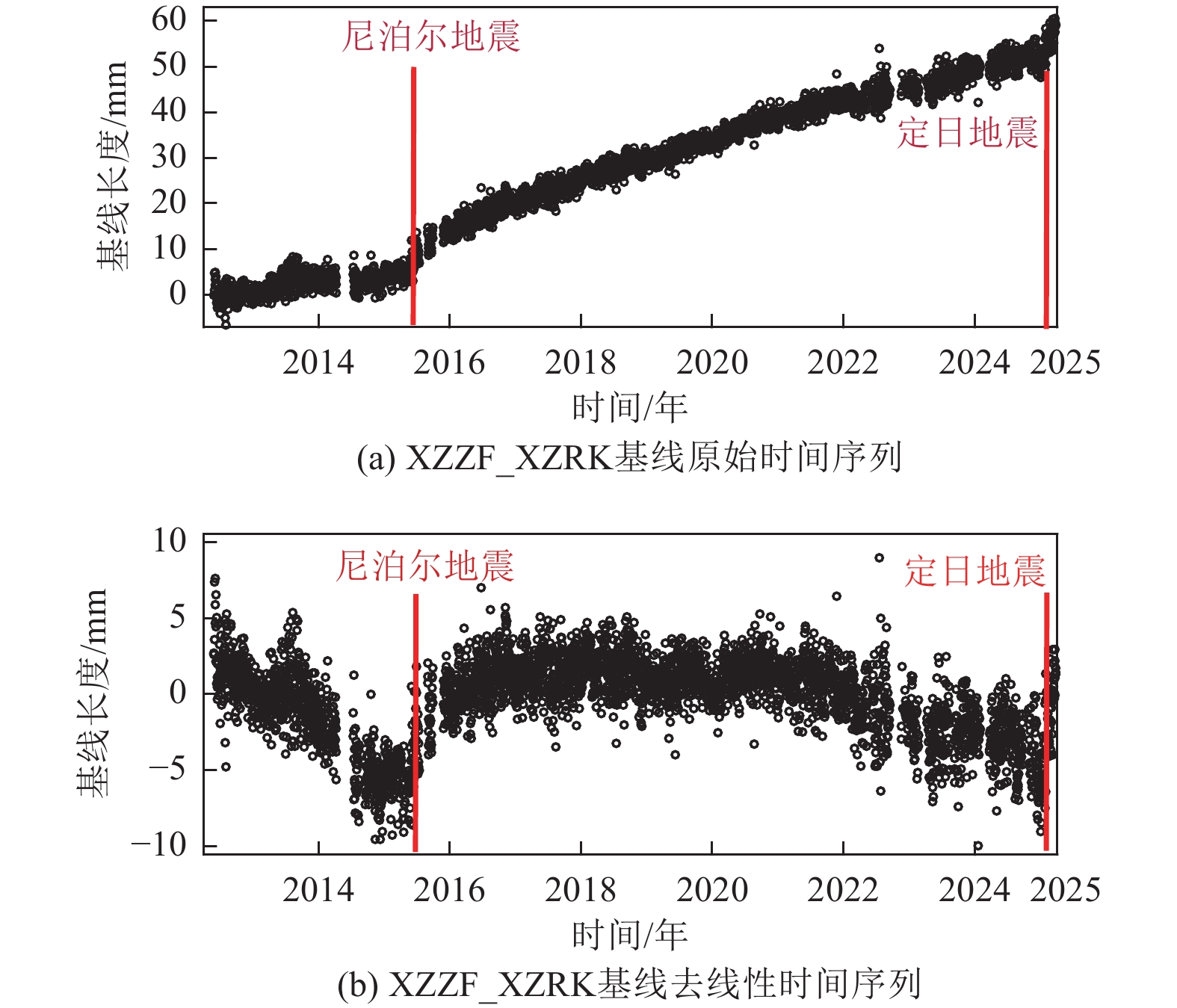
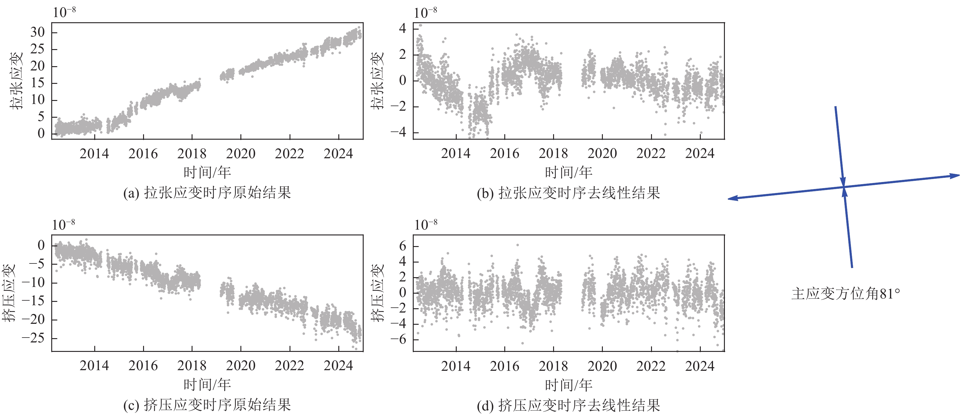
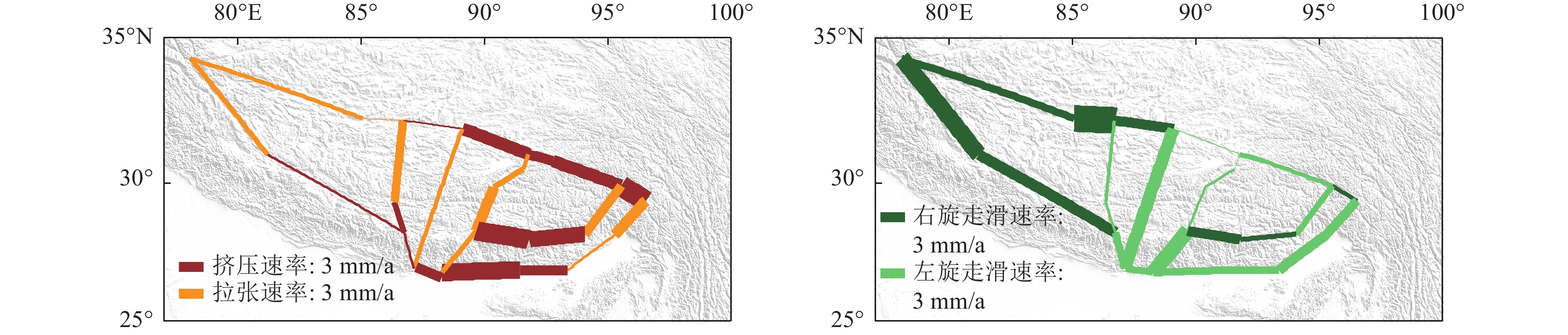
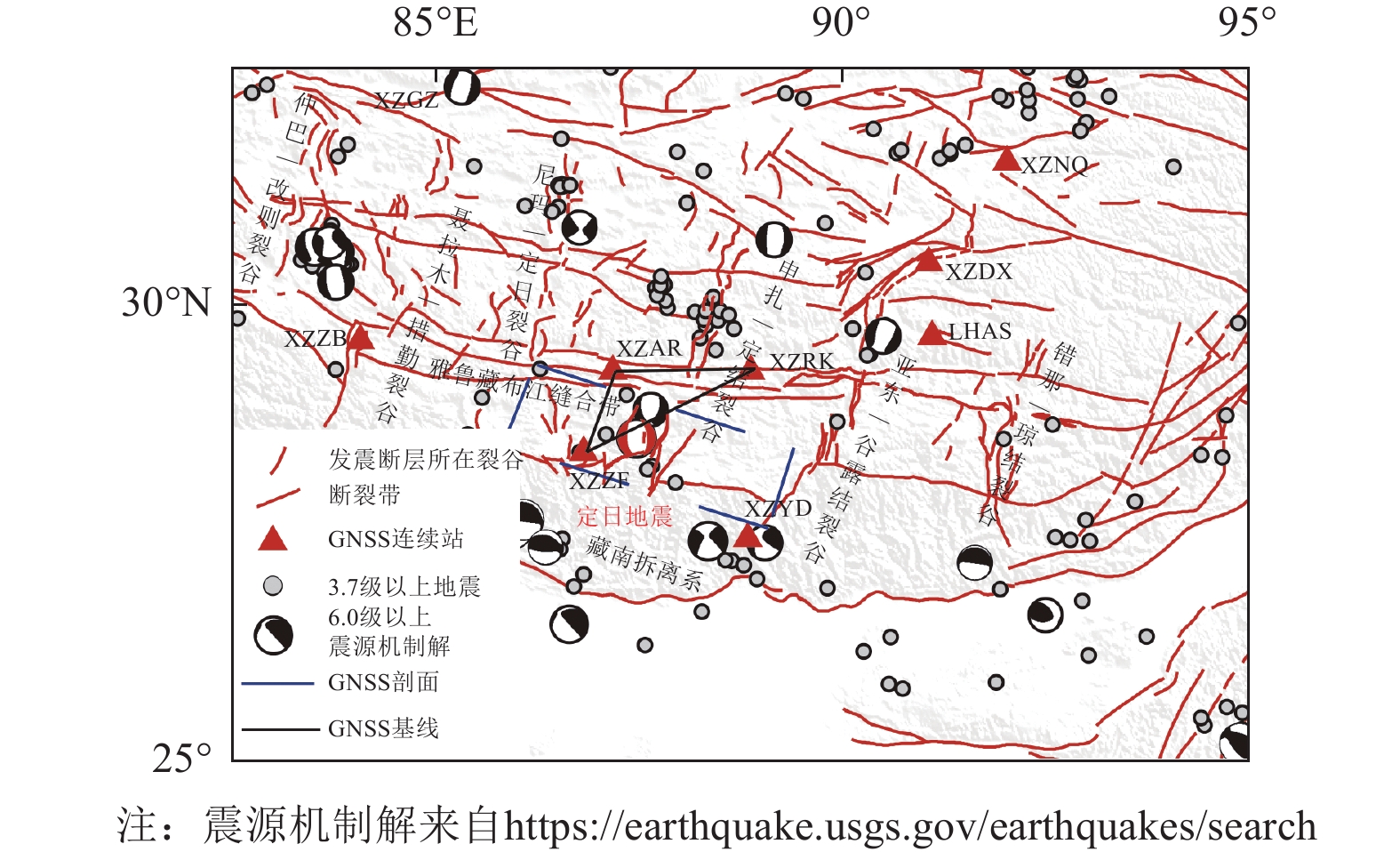
摘要: 北京时间2025年1月7日9点5分,在我国西藏定日县发生了6.8级地震。利用震中周边 GNSS连续观测数据反演获取同震位移场,结果表明,距离震中最近的测站为XZZF站,其同震位移量最大,南北向达到−17.14 mm,东西向达到−41.62 mm,基于震中周边3个站点的同震位移数据特征分析,此次地震呈现出典型的正断型地震运动学特征;对GNSS站间基线时间序列及区域应变时间序列的系统性研究结果显示,登么错断裂(又称丁木错断裂)带处于显著的拉张运动状态;震前 GNSS 动态应变场的分析结果表明,该区域的面应变由挤压逐渐变为拉张趋势,量值较小,且始终处在拉张应变高值区边缘;块体模型计算得到申扎-定结裂谷的左旋滑动速率为(3.2±0.5)mm/a,伸展速率为(1.4±0.6)mm/a,GNSS剖面计算得到发震断层登么错的拉张滑动速率为(1.58±0.6) mm/a,左旋滑动速率为(1.49±0.7) mm/a,裂谷南段的运动速率相对于整个裂谷运动速率较小,且处于应变高值区边缘,未来仍有发生强震的可能。Abstract: At 09:05 local time on January 7, 2025, a magnitude 6.8 earthquake occurred in Dingri County, Tibet, China. Inversion of co-seismic displacement fields using continuous GNSS observations from stations near the epicenter reveals that the station closest to the epicenter, XZZF, recorded the largest co-seismic displacement, with −17.14 mm in the north–south direction and −41.62 mm in the east–west direction. Analysis of co-seismic displacement data from three GNSS stations surrounding the epicenter indicates that the earthquake exhibits kinematic features characteristic of a typical normal faulting event. A comprehensive study of GNSS baseline time series and regional strain time series shows that the Dingmucuo fault zone is currently undergoing significant extensional deformation. Pre-seismic GNSS dynamic strain field analysis suggests that the regional areal strain transitioned from compressive to tensile, although the magnitude of this change remained small and the region was consistently located at the periphery of a high tensile strain zone. Block model calculations estimate the left-lateral slip rate of the Shenzha–Dingjie Rift to be (3.2 ± 0.5) mm/year, and the extensional (tensional) slip rate to be (1.4 ± 0.6) mm/year. GNSS profile analysis of the source fault, the Dingmucuo fault, yields an extensional slip rate of (1.58 ± 0.6)mm/year and a left-lateral slip rate of (1.49 ± 0.7)mm/year. Compared to the entire rift system, the southern segment of the Shenzha–Dingjie Rift exhibits relatively lower movement rates. However, the continued accumulation of regional strain suggests a persistent potential for future large-magnitude earthquakes.
-
Key words:
- Dingri earthquake /
- GNSS /
- Co-seismic /
- Strain /
- Slip rate
-
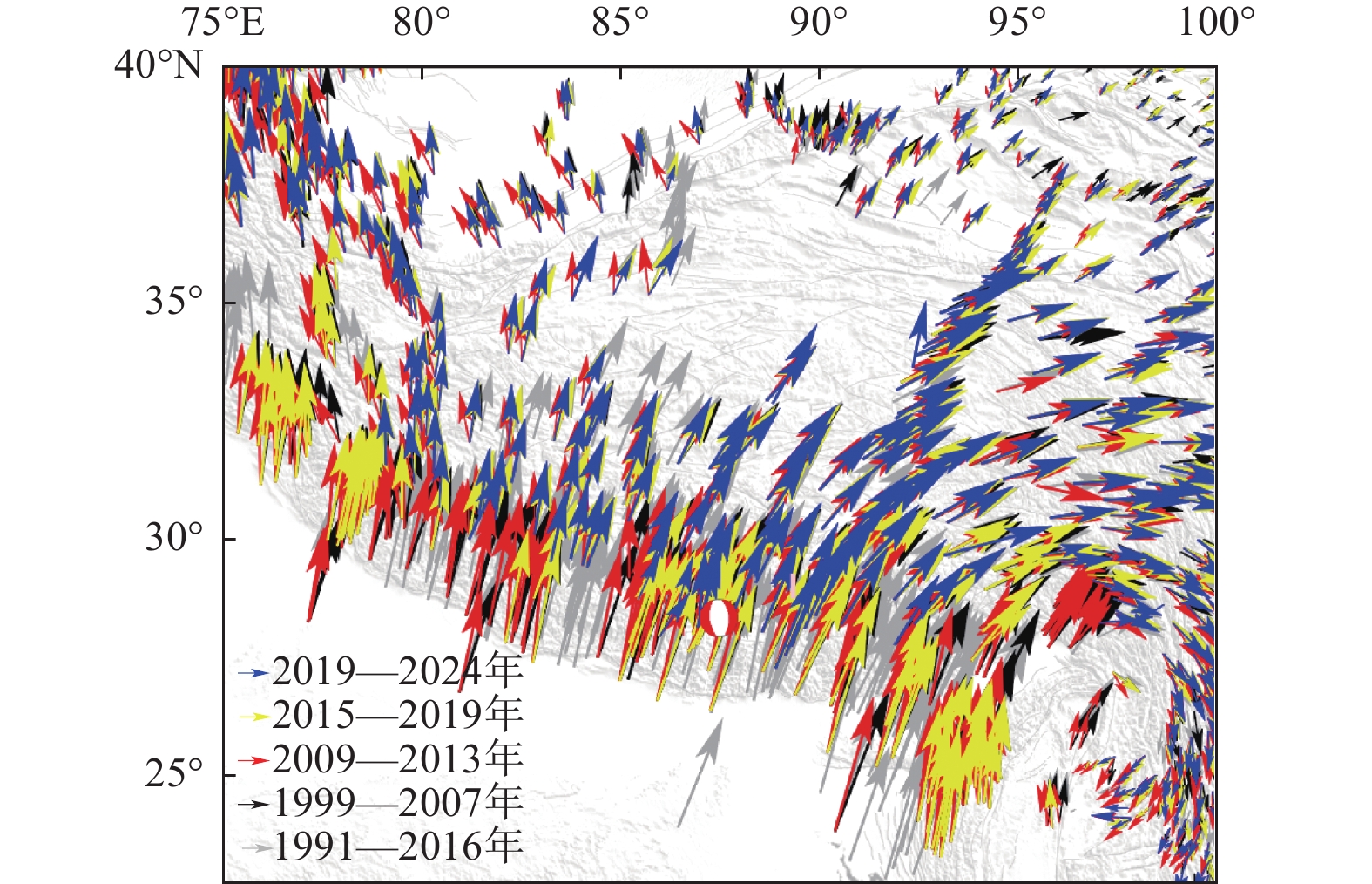
图 5 青藏高原多期速度场结果
Figure 5. Measured multi-period velocities on the Qinghai-Tibet plateau

图 8 输入GNSS速度场及解算残差
Figure 8. Distribution of GNSS velocity field and simulation residuals of GNSS
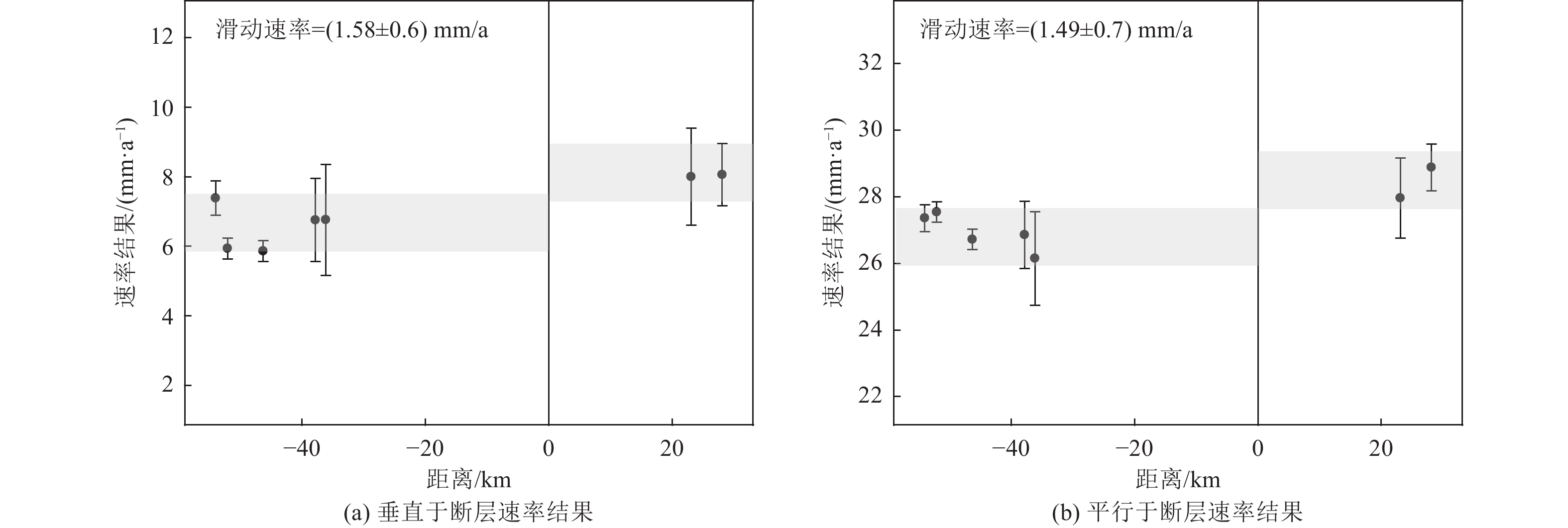
图 10 登么错断裂带GNSS剖面结果
Figure 10. The slip rates along the Dingmucuo fault by GNSS measurement
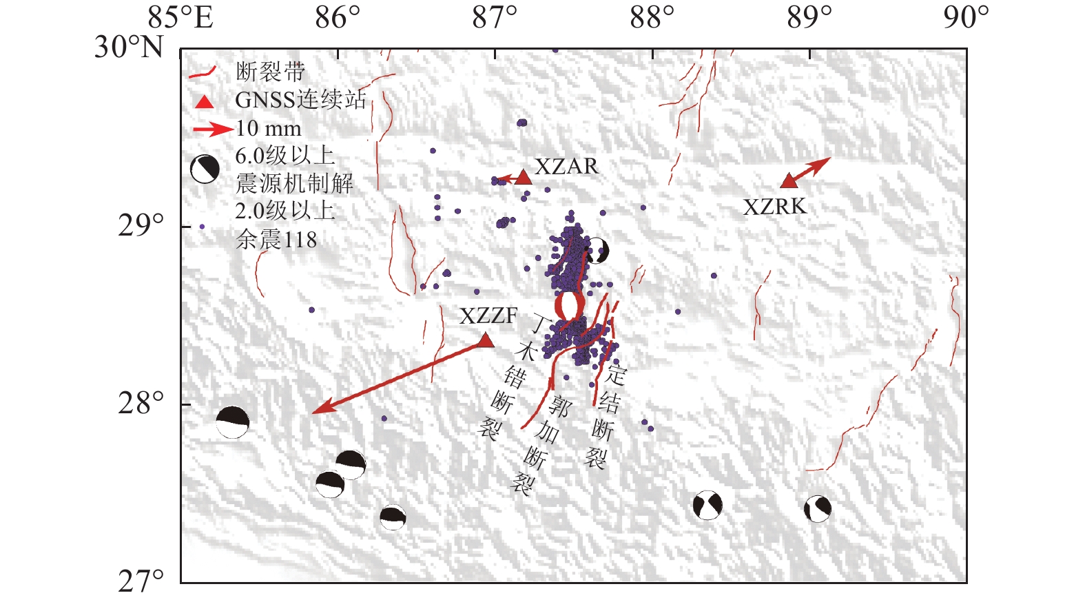
表 1 GNSS测站的同震位移量(单位:毫米)
Table 1. The co-seismic displacement measured from the GNSS stations (Unit: mm)
测站名称 东西向(东为正) 南北向(北为正) XZAR −6.51 0.04 XZRK 10.01 6.17 XZZF −41.62 −17.14  下载: 导出CSV
-
胡贵明,徐岳仁,刘晗等,2025. 藏南裂谷系正断层带孕震潜力和地震危险性讨论. 地球科学,1−26. (2025-04-02)[2025-04-27]. http://kns.cnki.net/kcms/detail/42.1874.p.20250402.1453.004.html.Hu G. M., Xu Y. R., Liu H., et al., 2025. Estimation of the maximum magnitutide of normal faults and seismic risk in the southern rift system of the Tibet Plateau. Earth Science,1−16. (2025-04-02)[2025-04-27]. http://kns.cnki.net/kcms/detail/42.1874.p.2025 0402.1453.004.html. (in Chinese) 李楠,刘陇强,朱利东等,2024. 喜马拉雅北缘登么错地堑第四纪软沉积物变形构造. 成都理工大学学报(自然科学版),51(6):1048−1059,1069. doi: 10.3969/j.issn.1671-9727.2024.06.12Li N., Liu L. Q., Zhu L. D., et al., 2024. Quaternary soft-sediment deformation structures in the Dingmucuo graben, northern Himalaya. Journal of Chengdu university of technology (Science & Technology Edition), 51(6): 1048−1059,1069. (in Chinese) doi: 10.3969/j.issn.1671-9727.2024.06.12 李琦,李承涛,赵斌等,2024. 2020年西藏定日MW5.6地震震源参数估计和应力触发研究. 地球物理学报,67(1):172−188. doi: 10.6038/cjg2022Q0234Li Q., Li C. T., Zhao B., et al., 2024. Estimated seismic source parameters for 2020 Dingri MW5.6 earthquake in Xizang and study on the stress triggering. Chinese Journal of Geophysics, 67(1): 172−188. (in Chinese) doi: 10.6038/cjg2022Q0234 刘富财,潘家伟,李海兵等,2025. 2025年MW7.1西藏定日地震地表破裂与同震位移分布特征. 地质学报,99(3):685−703.Liu F. C., Pan J. W., Li H. B., et al., 2025. Co-seismic surface rupture of the 2025 Mw7.1 Tingri earthquake and potential Seismic risk in southern Tibetan Plateau. Acta Geologica Sinica, 99(3): 685−703. (in Chinese) 倪乙鹏,2021. 利用GPS&InSAR研究藏南甲岗−定结裂谷现今构造活动特征. 武汉:中国地震局地震研究所.Ni Y. P., 2021. Study on the present-day tectonic activity of Jiagang-Dinggye rift in southern Tibet by using GPS & InSAR. Wuhan:Institute of Seismology,China Earthquake Administration. (in Chinese) 石峰,梁明剑,罗全星等,2025. 2025年1月7日西藏定日6.8级地震发震构造与同震地表破裂特征. 地震地质,47(1):1−15. doi: 10.3969/j.issn.0253-4967.2025.01.001Shi F., Liang M. J., Luo Q. X., et al., 2025. Seismogenic fault and coseismic surface deformation of the Dingri MS6.8 earthquake in Xizang, China. Seismology and Geology, 47(1): 1−15. (in Chinese) doi: 10.3969/j.issn.0253-4967.2025.01.001 谭凯,赵斌,张彩红等,2016. GPS和InSAR同震形变约束的尼泊尔MW7.9和MW7.3地震破裂滑动分布. 地球物理学报,59(6):2080−2093. doi: 10.6038/cjg20160614Tan K., Zhao B., Zhang C. H., et al., 2016. Rupture models of the Nepal MW7.9 earthquake and MW7.3 aftrershock constrained by GPS and InSAR coseismic deformations. Chinese Journal of Geophysics, 59(6): 2080−2093. (in Chinese) doi: 10.6038/cjg20160614 田婷婷,吴中海,2023. 西藏申扎−定结裂谷南段登么错正断层的最新史前大地震事件及其地震地质意义. 地质论评,69(S1):53−55.Tian T. T., Wu Z. H., 2023. Recent prehistoric major earthquake event of Dingmucuo Normal fault in the southern segment of Shenzha-Dingjie Rift and its seismic geological significance. Geological Review, 69(S1): 53−55. (in Chinese) 万永革,盛书中,李祥等,2015. 2015年尼泊尔强震序列对中国大陆的应力影响. 地球物理学报,58(11):4277−4286. doi: 10.6038/cjg20151132Wan Y. G., Sheng S. Z., Li X., et al., 2015. Stress influence of the 2015 Nepal earthquake sequence on Chinese mainland. Chinese Journal of Geophysics, 58(11): 4277−4286. (in Chinese) doi: 10.6038/cjg20151132 武艳强,江在森,朱爽等,2020. 中国大陆西部GNSS变形特征及其与M≥7.0强震孕育的关系. 中国地震,36(4):756−766.Wu Y. Q., Jiang Z. S., Zhu S., et al., 2020. GNSS deformation characteristics and its relationship with M≥7.0 strong earthquakes in western China. Earthquake Research in China, 36(4): 756−766. (in Chinese) 熊维,谭凯,刘刚等,2015. 2015年尼泊尔MW7.9地震对青藏高原活动断裂同震、震后应力影响. 地球物理学报,58(11):4305−4316. doi: 10.6038/cjg20151135Xiong W., Tan K., Liu G., et al., 2015. Coseismic and postseismic Coulomb stress changes on surrounding major faults caused by the 2015 Nepal MW7.9 earthquake. Chinese Journal of Geophysics, 58(11): 4305−4316. (in Chinese) doi: 10.6038/cjg20151135 徐心悦,2019. 藏南申扎−定结断裂系卡达正断裂晚第四纪活动性及其环境效应. 北京:中国地震局地质研究所.Xu X. Y., 2019. Late quaternary activity and its environmental effects of the N-S trend Kharta fault in Xainza-Dinggye rift,Southern Tibet. Beijing:Institute of Geology,China Earthquake Administration. (in Chinese) 杨国华,杨博,占伟等,2012. GPS资料反映大震前后青藏高原东北缘的水平形变. 地震研究,35(3):295−302. doi: 10.3969/j.issn.1000-0666.2012.03.001Yang G. H., Yang B., Zhan W., et al., 2012. Horizontal deformation of the northeastern edge of Qinghai-Tibetan Plateau before and after largre earthquake reflected by GNSS data. Journal of Seismological Research, 35(3): 295−302. (in Chinese) doi: 10.3969/j.issn.1000-0666.2012.03.001 杨婷,王世广,房立华等,2025. 2025年1月7日西藏定日MS6.8地震余震序列特征与发震构造. 地球科学,50(05):1721−1732.Yang T., Wang S. G., Fang L. H., et al., 2025. Analysis of earthquake sequence and seismogenic structure of the 2025 MS6.8 dingri earthquake in Tibetan Plateau. Earth Science, 50(05): 1721−1732. (in Chinese) 张进江,郭磊,丁林,2002. 申扎-定结正断层体系中、南段构造特征及其与藏南拆离系的关系. 科学通报,47(10):738−743.Zhang J. J., Guo L., Ding L., 2002. Structural characteristics of middle and southern Xainza-Dinggye normal fault system and its relationship to Southern Tibetan detachment system. Chinese Science Bulletin,47(13):1063−1069. (in Chinese) 张培震,邓起东,张国民等,2003. 中国大陆的强震活动与活动地块. 中国科学(D辑),33(S1):12−20.Zhang P. Z., Deng Q. D., Zhang G. M. ,et al. ,2003. Active tectonic blocks and strong earthquakes in the continent of China. Science in China Series D:Earth Sciences,46(S2):13−24. (in Chinese) 朱爽,占伟,刘晓等,2024. 新疆乌什7.1级地震前GNSS变形特征分析. 地震工程学报,46(4):973−981.Zhu S., Zhan W., Liu X., et al., 2024. Deformation characteristics before the M7.1 earthquake in Wushi, Xinjiang, from GNSS observation data. China Earthquake Engineering Journal, 46(4): 973−981. (in Chinese) Armijo R., Tapponnier P., Han T. L., 1989. Late Cenozoic right-lateral strike-slip faulting in southern Tibet. Journal of Geophysical Research: Solid Earth, 94(B3): 2787−2838. doi: 10.1029/JB094iB03p02787 Bettinelli P., Avouac J. P., Flouzat M., et al., 2006. Plate motion of India and interseismic strain in the Nepal Himalaya from GPS and DORIS measurements. Journal of Geodesy, 80(8-11): 567−589. doi: 10.1007/s00190-006-0030-3 Bian S., Gong J. F., Zuzà A V., et al., 2022. Along-strike variation in the initiation timing of the north-trending rifts in southern Tibet as revealed from the Yadong-Gulu rift. Tectonics, 41(7): e2021TC007091. doi: 10.1029/2021TC007091 Kali E., Leloup P. H., Arnaud N., et al., 2010. Exhumation history of the deepest central Himalayan rocks, Ama Drime range: key pressure-temperature‐deformation‐time constraints on orogenic models. Tectonics, 29(2): TC2014. Meade B. J., Hager B. H., 2005. Block models of crustal motion in southern California constrained by GPS measurements. Journal of Geophysical Research: Solid Earth, 110(B3): B03403. Monsalve G., Sheehan A., Schulte-Pelkum V., et al., 2006. Seismicity and one-dimensional velocity structure of the Himalayan collision zone: earthquakes in the crust and upper mantle. Journal of Geophysical Research: Solid Earth, 111(B10): B10301. Wang M., Shen Z. K., 2020. Present-day crustal deformation of continental China derived from GPS and its tectonic implications. Journal of Geophysical Research: Solid Earth, 125(2): e2019JB018774. doi: 10.1029/2019JB018774 Wolff R., Hetzel R., Hölzer K., et al., 2023. Rift propagation in south Tibet controlled by under-thrusting of India: a case study of the Tangra Yumco graben (south Tibet). Journal of the Geological Society, 180(2): jgs2022−090. Wu Y. Q., Jiang Z. S., Yang G. H., et al., 2011. Comparison of GPS strain rate computing methods and their reliability. Geophysical Journal International, 185(2): 703−717. doi: 10.1111/j.1365-246X.2011.04976.x -


 点击查看大图
计量
- 文章访问数: 248
- HTML全文浏览量: 72
- PDF下载量: 27
- 被引次数: 0
