
Late Quaternary Faulted Landforms and Determination of Slip Rate of Jinqanghe Segment of Maya Snow Mountain Fault
-
摘要: 祁连山东段发育了多条大型活动断裂,如近东西向展布的天桥沟-黄羊川断裂及北西西向展布的金强河断裂、毛毛山断裂、老虎山断裂等,在马雅雪山北麓、宝泉山隆起北缘还发育了一条整体呈北西-北西西向展布的马雅雪山断裂。其中,前人已对天桥沟-黄羊川断裂、金强河断裂、毛毛山断裂、老虎山断裂的晚第四纪活动开展了大量的研究,相比而言,马雅雪山断裂的研究程度还较低,其最新构造活动特征及其与区域主干活动断裂之间的关系等尚不清楚。马雅雪山断裂构成了天祝盆地与南部山体、丘陵的分界线,迹线清晰,断层三角面、断层槽谷多见,局部冲洪积阶地可见线性展布的断层陡坎,显示出断裂在晚第四纪有一定的活动。本研究对马雅雪山断裂西部的金强河段开展了实地调查,重点对马营沟及小黑刺沟2处的阶地断层陡坎开展了高精度地形地貌测量及阶地地貌面定年,对滑动速率进行了厘定。研究结果表明,马雅雪山断裂金强河段晚第四纪活动显著,断裂最近强震活动发生在8.21~3.43 ka BP,晚更新世晚期以来的垂直滑动速率为0.45~0.63 mm/a。Abstract: Several large active faults have developed in the eastern section of the Qilian Mountains, including the near east-west trending Tianqiaogou-Huangyangchuan fault, the northwest-west trending Jinqianghe fault, Maomaoshan fault, Laohushan fault, and the northwest to northwest-west trending Maya Snow Mountain fault. While extensive research has been conducted on the late Quaternary activity of the Tianqiaogou-Huangyangchuan, Jinqianghe, Maomaoshan, and Laohushan faults, the Maya Snow Mountain fault remains comparatively under-researched, particularly in terms of quantitative studies. The recent activity characteristics and relationship with the regional active faults remain unclear. The Maya Snow Mountain fault, which extends approximately 150 km and passes through Tianzhu city and several villages, serves as the boundary between the Tianzhu basin and the southern mountains and hills. Fault triangles and troughs are common along this fault, and linear fault scarps are visible on some alluvial and proluvial terraces, suggesting activity during the late Quaternary. Given its proximity to populated areas, further investigation into its activity is crucial. In this study, we focus on the Jinqianghe segment of the Maya Snow Mountain fault, located in the fault's western section. We conducted high-precision topographic and geomorphic measurements, dated terraces, and determined fault slip rates at the Maying River and Xiaoheici River fault scarps. Our findings indicate that the Jinqianghe segment of the Maya Snow Mountain Fault was significantly active during the late Quaternary and remains active into the early Holocene. A strong earthquake occurred at 8.21 ~ 3.43 ka BP, with vertical slip rate since the late Pleistocene estimated at 0.45 to 0.63 mm/a.
-
Key words:
- Maya Snow Mountain fault /
- Late Quaternary /
- Faulted landform /
- Slip rate
-

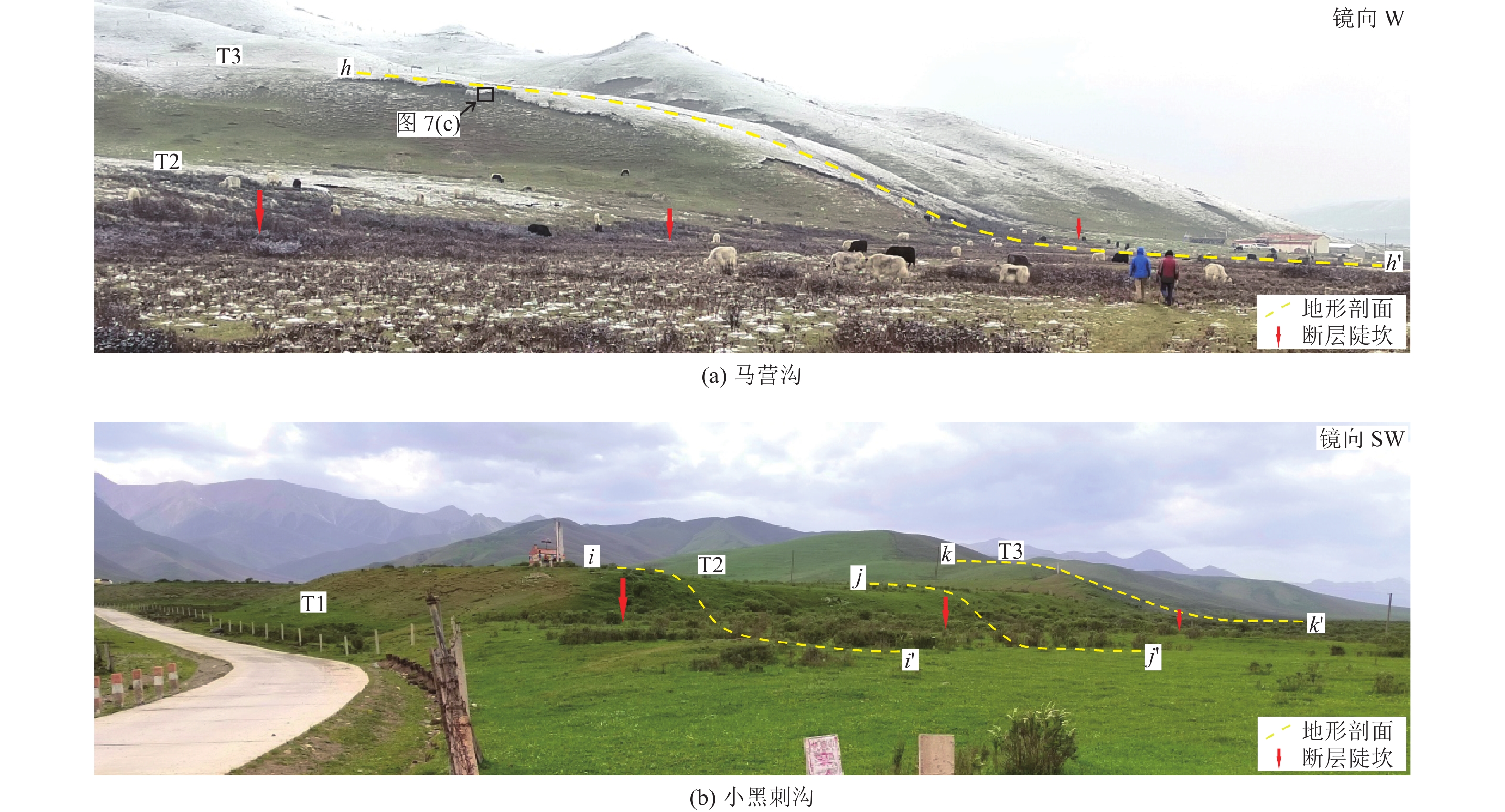
图 1 马雅雪山断裂金强河段周边地貌及断裂展布
Figure 1. Landforms and fault distribution around the Jinqianghe segment of the Maya Snow Mountain fault

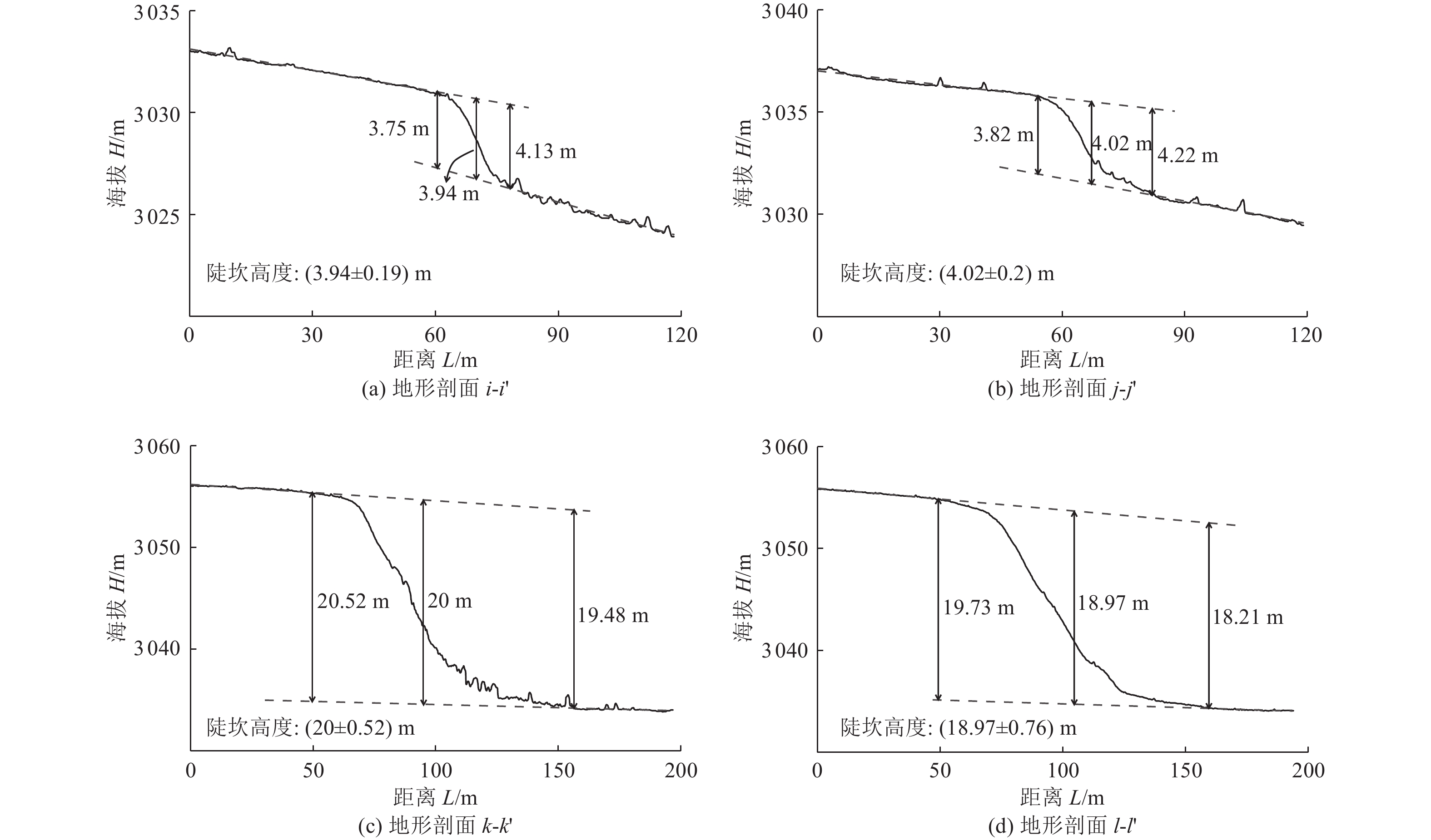
图 3 马营沟西DSM及典型部位地形剖面测量
Figure 3. DSM of Maying river west and topographic profile measurements at typical positions

图 5 小黑刺沟西DSM及典型部位地形剖面测量
Figure 5. DSM of Xiaoheici river west and topographic profile measurements at typical positions

图 7 阶地采样剖面照片及地质剖面图
Figure 7. Location of sample collection and corresponding geological profiles
表 1 样品光释光测试参数及年龄
Table 1. OSL dating results of the samples
样品编号 埋深/m U/(μg·g−1) Th/(μg·g−1) K/% 含水量/% 环境剂量率/(Gy·ka−1) 等效剂量/Gy 年代/(ka BP) OSL-MY-3 0.87 2.67±0.06 14.4±0.19 2.14±0.02 2.05 4.87±0.36 35.64±1.05 7.33±0.58 OSL-MY-4 0.49 2.75±0.05 14.8±0.38 2±0.01 6.31 4.59±0.32 37.02±1.68 8.06±0.67 OSL-MY-5 0.53 2.71±0.06 14±0.36 1.9±0.01 3.59 4.54±0.33 156.74±7.78 34.56±3.02 OSL-MY-6 0.55 2.56±0.02 14.7±0.28 2.23±0.02 5.05 4.8±0.34 44.43±2.28 9.25±0.81 OSL-MY-7 0.6 3.21±0.03 17±0.19 2.32±0.02 5.13 5.33±0.38 18.29±0.57 3.43±0.27 OSL-MY-8 0.45 2.49±0.03 14.1±0.27 2.02±0.02 2.57 4.66±0.34 2.34±0.09 0.5±0.04  下载: 导出CSV
-
丁锐,李环宇,张世民等,2022. 基于网络/基站RTK移动摄影测量数据的垂向精度分析. 震灾防御技术,17(1):68−78. doi: 10.11899/zzfy20220107Ding R., Li H. Y., Zhang S. M., et al., 2022. Analysis of vertical accuracy based on network/base station RTK-SfM data. Technology for Earthquake Disaster Prevention, 17(1): 68−78. (in Chinese) doi: 10.11899/zzfy20220107 高伟,2018. 天桥沟−黄羊川断裂晚第四纪活动特征及其构造意义. 北京:中国地震局地质研究所.Gao W., 2018. Late quaternary activity of the tianqiaogou-huangyangchuan fault:implication for the tectonic movement mechanism at the Northeastern Tibet. Beijing:Institute of Geology,China Earthquake Administration. (in Chinese) 郭鹏,韩竹军,安艳芬等,2017. 冷龙岭断裂系活动性与2016年门源6.4级地震构造研究. 中国科学:地球科学,47(5):617−630.Guo P., Han Z. J., An Y. F, et al. , 2017. Activity of the Lenglongling fault system and seismotectonics of the 2016 M S6.4 Menyuan earthquake. Science China Earth Sciences, 60(5): 929−942. (in Chinese) 郝明,李煜航,秦姗兰,2017. 基于GPS数据的海原-六盘山断裂带滑动速率亏损时空分布. 地震地质,39(3):471−484. doi: 10.3969/j.issn.0253-4967.2017.03.003Hao M., Li Y. H., Qin S. L., 2017. Spatial and temporal distribution of slip rate deficit across Haiyuan-Liupan Shan fault zone constrained by GPS data. Seismology and Geology, 39(3): 471−484. (in Chinese) doi: 10.3969/j.issn.0253-4967.2017.03.003 黄伟亮,杨晓平,李胜强等,2018. 焉耆盆地北缘断裂全新世滑动速率及地震危险性. 地震地质,40(1):186−203. doi: 10.3969/j.issn.0253-4967.2018.01.014Huang W. L., Yang X. P., Li S. Q., et al., 2018. Holocene slip rate and earthquake hazard of the north-edge fault of the Yanqi Basin, southeastern Tian Shan, China. Seismology and Geology, 40(1): 186−203. (in Chinese) doi: 10.3969/j.issn.0253-4967.2018.01.014 蒋锋云,季灵运,赵强,2021. 海原-六盘山断裂带现今地震危险性的数值模拟分析. 地质力学学报,27(2):230−240. doi: 10.12090/j.issn.1006-6616.2021.27.02.022Jiang F. Y., Ji L. Y., Zhao Q., 2021. Numerical simulation of the present seismic risk of the Haiyuan - Liupanshan fault zone. Journal of Geomechanics, 27(2): 230−240. (in Chinese) doi: 10.12090/j.issn.1006-6616.2021.27.02.022 李延川,2016. 基于GPS的海原断裂变形特征及强震危险性分析. 青岛:中国石油大学(华东).Li Y. C., 2016. Deformation characteristics and seismic hazard evaluation of the Haiyuan fault based on GPS. Qingdao: China University of Petroleum (East China). (in Chinese) 刘金瑞,任治坤,张会平等,2018. 海原断裂带老虎山段晚第四纪滑动速率精确厘定与讨论. 地球物理学报,61(4):1281−1297. doi: 10.6038/cjg2018L0364Liu J. R., Ren Z. K., Zhang H. P., et al., 2018. Late Quaternary slip rate of the Laohushan fault within the Haiyuan fault zone and its tectonic implications. Chinese Journal of Geophysics, 61(4): 1281−1297. (in Chinese) doi: 10.6038/cjg2018L0364 刘静,陈涛,张培震等,2013. 机载激光雷达扫描揭示海原断裂带微地貌的精细结构. 科学通报,58(1):41−45. doi: 10.1360/972012-1526Liu J., Chen T., Zhang P. Z., et al., 2013. Illuminating the active Haiyuan fault, China by airborne light detection and ranging. Chinese Science Bulletin, 58(1): 41−45. (in Chinese) doi: 10.1360/972012-1526 刘雷,朱良玉,庄文泉,2022. 2022年门源 M S 6.9地震前祁连−海原断裂带闭锁程度研究. 地震地磁观测与研究,43(S1):433−436.Liu L., Zhu L. Y., Zhuang W. Q., 2022. Study on the locking degree of the Qilian-Haiyuan fault zone before the 2022 Menyuan M S 6.9 earthquake. Seismological and Geomagnetic Observation and Research, 43(S1): 433−436. (in Chinese) 牛继荣,张环,张富芳等,2005. 天祝地震危险区划研究. 防灾技术高等专科学校学报,7(3):60−64.Niu J. R., Zhang H., Zhang F. F., et al., 2005. A research on the earthquake hazardous area zoning in Tianzhu. Journal of College of Disaster Prevention Techniques, 7(3): 60−64. (in Chinese) 潘保田,苏怀,刘小丰等,2007. 兰州东盆地最近1.2Ma的黄河阶地序列与形成原因. 第四纪研究,27(2):172−180. doi: 10.3321/j.issn:1001-7410.2007.02.002Pan B. T., Su H., Liu X. F., et al., 2007. River terraces of the Yellow River and their genesis in eastern Lanzhou Basin during last 1.2 Ma. Quaternary Sciences, 27(2): 172−180. (in Chinese) doi: 10.3321/j.issn:1001-7410.2007.02.002 乔鑫,屈春燕,单新建等,2019. 基于时序InSAR的海原断裂带形变特征及运动学参数反演. 地震地质,41(6):1481−1496. doi: 10.3969/j.issn.0253-4967.2019.06.011Qiao X., Qu C. Y., Shan X. J., et al., 2019. Deformation characteristics and kinematic parameters inversion of Haiyuan fault zone based on time series InSAR. Seismology and Geology, 41(6): 1481−1496. (in Chinese) doi: 10.3969/j.issn.0253-4967.2019.06.011 任治坤,陈涛,张会平等,2014. LiDAR技术在活动构造研究中的应用. 地质学报,88(6):1196−1207.Ren Z. K., Chen T., Zhang H. P., et al., 2014. LiDAR survey in active tectonics studies: an introduction and overview. Acta Geologica Sinica, 88(6): 1196−1207. (in Chinese) 孙赫,徐晶,柳皓元,2017. 基于InSAR的广义海原断裂带中东段现今深部运动特征. 大地测量与地球动力学,37(11):1141−1145.Sun H., Xu J., Liu H. Y., 2017. Depth present-day movement in the mid-eastern segment of the Haiyuan fault zone based on InSAR. Journal of Geodesy and Geodynamics, 37(11): 1141−1145. (in Chinese) 唐清,郑文俊,石霖等,2020. 基于高精度LiDAR数据的断裂活动习性精细定量−−以香山-天景山断裂景泰小红山段为例. 地震地质,42(2):366−381. doi: 10.3969/j.issn.0253-4967.2020.02.008Tang Q., Zheng W. J., Shi L., et al., 2020. Quantitative study of fault activity based on high-precision airborne LiDAR data: a case of Xiaohongshan Fault in Xiangshan-Tianjingshan Fault Zone. Seismology and Geology, 42(2): 366−381. (in Chinese) doi: 10.3969/j.issn.0253-4967.2020.02.008 王永成,刘百篪,2001. 祁连山中东段断裂的地震危险性分析. 西北地震学报,23(4):330−338.Wang Y. C., Liu B. C., 2001. Analysis on seismic risk for faults in the mid-Eastern Qilianshan area. Northwestern Seismological Journal, 23(4): 330−338. (in Chinese) 魏占玉,何宏林,石峰等,2012. 大凉山断裂带南段滑动速率估计. 地震地质,34(2):282−293. doi: 10.3969/j.issn.0253-4967.2012.02.007Wei Z. Y., He H. L., Shi F., et al., 2012. Slip rate on the south segment of Daliangshan fault zone. Seismology and Geology, 34(2): 282−293. (in Chinese) doi: 10.3969/j.issn.0253-4967.2012.02.007 姚文倩,2019. 海原断裂老虎山段及其邻区晚第四纪活动性及几何复杂度研究. 北京:中国地震局地质研究所.Yao W. Q., 2019. Late quaternary activity and geometric complexity of the Laohu Shan section and its adjacent area. Beijing:Institute of Geology,China Earthquake Administration. (in Chinese) 俞晶星,2013. 雅布赖山前断裂晚第四纪滑动速率与古地震. 北京:中国地震局地质研究所.Yu J. X., 2013. Late quaternary slip rates and paleoearthquakes along the Yabrai Range-front fault in the southern gobi-alashan block. Beijing:Institute of Geology,China Earthquake Administration. (in Chinese) 袁道阳,刘百篪,吕太乙等,1998. 北祁连山东段活动断裂带的分段性研究. 西北地震学报,20(4):27−34.Yuan D. Y., Liu B. C., Lü T. Y., et al., 1998. Study on the segmentation in east segment of the northern Qilianshan fault zone. Northweatern Seismological Journal, 20(4): 27−34. (in Chinese) 张会平,张培震,郑德文等,2012. 祁连山构造地貌特征:青藏高原东北缘晚新生代构造变形和地貌演化过程的启示. 第四纪研究,32(5):907−920. doi: 10.3969/j.issn.1001-7410.2012.05.08Zhang H. P., Zhang P. Z., Zheng D. W., et al., 2012. Tectonic geomorphology of the Qilian Shan: Insights into the late Cenozoic landscape evolution and deformation in the north eastern Tibetan Plateau. Quaternary Sciences, 32(5): 907−920. (in Chinese) doi: 10.3969/j.issn.1001-7410.2012.05.08 张培震,李传友,毛凤英,2008. 河流阶地演化与走滑断裂滑动速率. 地震地质,30(1):44−57. doi: 10.3969/j.issn.0253-4967.2008.01.004Zhang P. Z., Li C. Y., Mao F. Y., 2008. Strath terrace formation and strike-slip faulting. Seismology and Geology, 30(1): 44−57. (in Chinese) doi: 10.3969/j.issn.0253-4967.2008.01.004 朱琳,戴勇,石富强等,2022. 祁连−海原断裂带库仑应力演化及地震危险性. 地震学报,44(2):223−236. doi: 10.11939/jass.20220012Zhu L., Dai Y., Shi F. Q., et al., 2022. Coulomb stress evolution and seismic hazards along the Qilian-Haiyuan fault zone. Acta Seismologica Sinica, 44(2): 223−236. (in Chinese) doi: 10.11939/jass.20220012 Thompson S. C., Weldon R. J., Rubin C. M., et al., 2002. Late Quaternary slip rates across the central Tien Shan, Kyrgyzstan, central Asia. Journal of Geophysical Research: Solid Earth, 107(B9): 2203. Zheng W. J., Zhang P. Z., Ge W. P., et al., 2013. Late Quaternary slip rate of the South Heli Shan Fault (northern Hexi Corridor, NW China) and its implications for northeastward growth of the Tibetan Plateau. Tectonics, 32(2): 271−293. doi: 10.1002/tect.20022 -


 点击查看大图
计量
- 文章访问数: 1032
- HTML全文浏览量: 93
- PDF下载量: 65
- 被引次数: 0
