
Accuracy Analysis of Typical Seismic Source Locations in Shanxi Region
-
摘要: 针对当前地震定位误差分析的不足,本文提出了利用数值模拟定量计算地震定位准确度的方法,并选择近年来山西断陷带典型地震事件进行测试分析。结果显示,山西断陷带典型地震(ML≥3.6)定位精度基本小于5 km,南北两端的大同、运城盆地地震定位精度显著低于中部3个盆地;地震定位精度与参与定位的台站数量和最大空隙角密切相关;当最大空隙角相近时,地震定位的可信度随着参与定位的台站数量增多而升高。Abstract: To address deficiencies in the current analysis of seismic location errors, this study proposes a numerical simulation-based method to quantitatively assess seismic location accuracy. This approach is applied to typical seismic events in the Shanxi fault depression in recent years. The results indicate that the seismic location accuracy for events with ML≥3.6 in the Shanxi Rift Zone is within 5 km. However, the accuracy in the Datong and Yuncheng basins, located at the northern and southern ends of the rift, is significantly lower than that in the three central basins. Furthermore, seismic location accuracy is closely related to the number of seismic stations and the maximum gap angle. When the maximum gap angle is comparable, location reliability improves as the number of contributing stations increases.
-
Key words:
- Shanxi rift zone /
- Positioning accuracy /
- Probability statistics /
- Error analysis
-
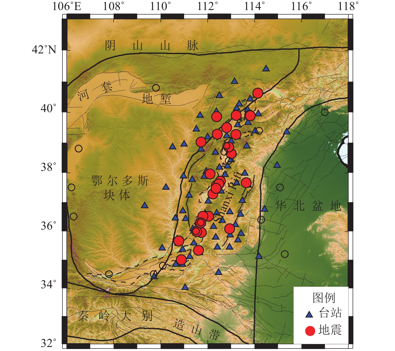
图 1 山西台站及测试地震事件分布图
Figure 1. Station distribution and monitoring capacity of Shanxi province
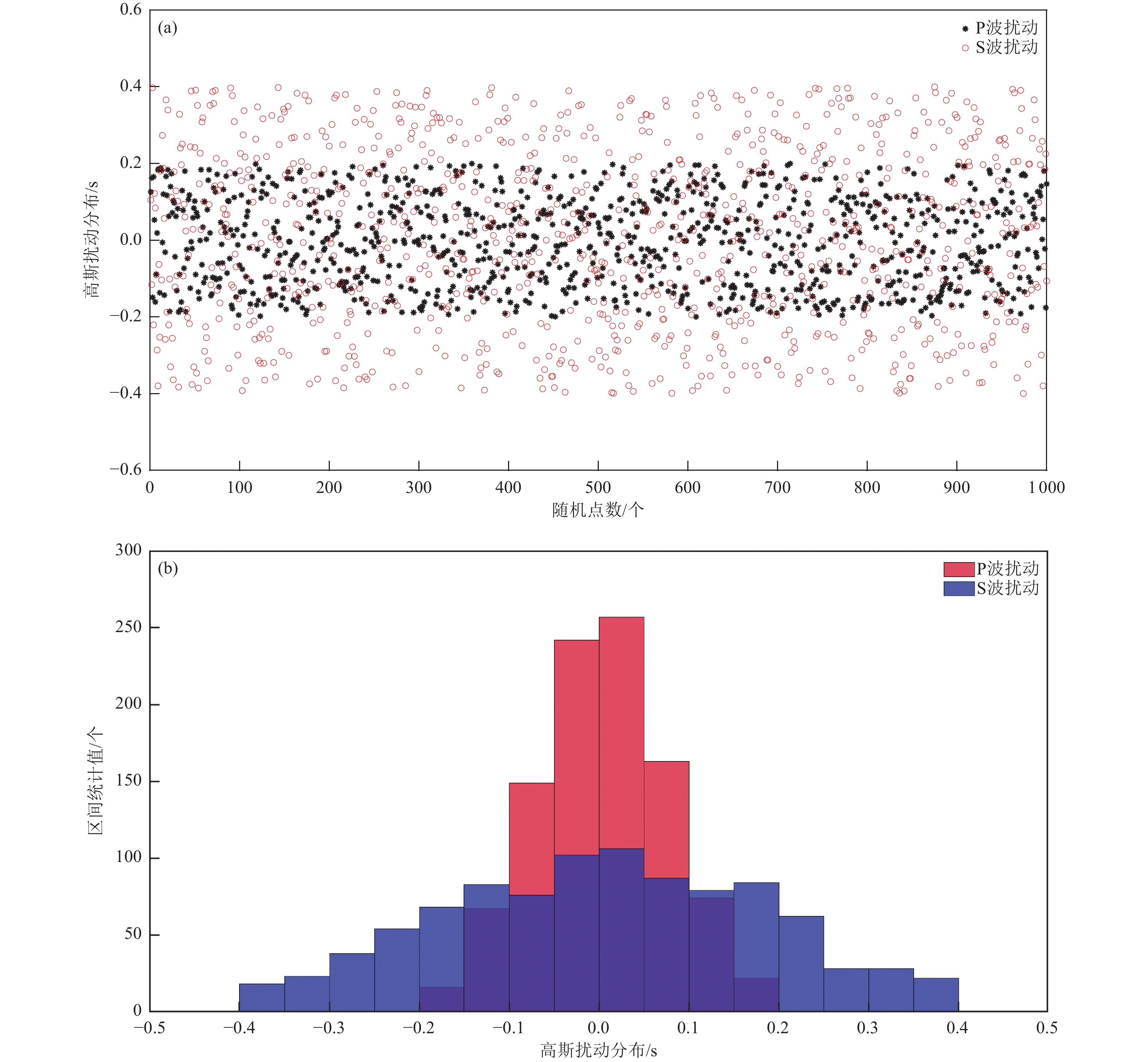
图 3 高斯扰动的散点和直方图分布
Figure 3. Scatter and histogram distribution of Gaussian perturbations
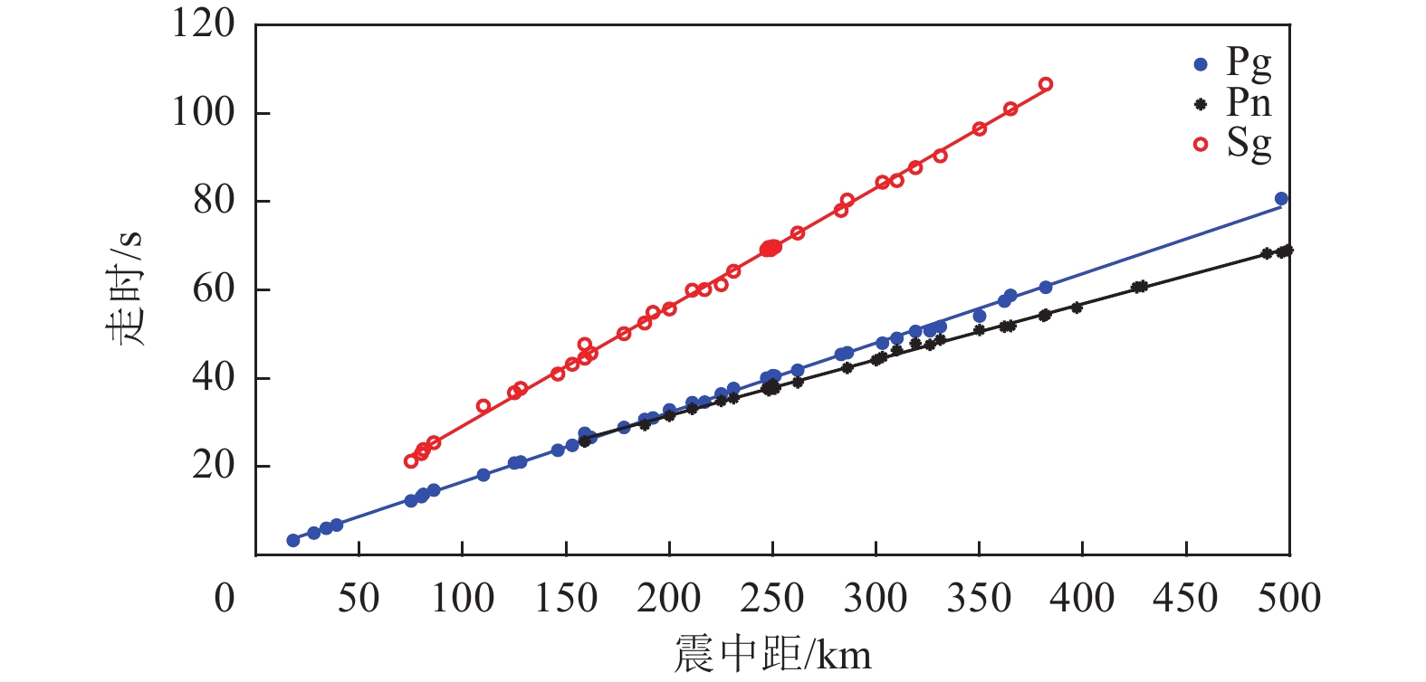
图 4 不同震相震中距-走时拟合图
Figure 4. Plot of different phase epicentral-distance-travel time fitting
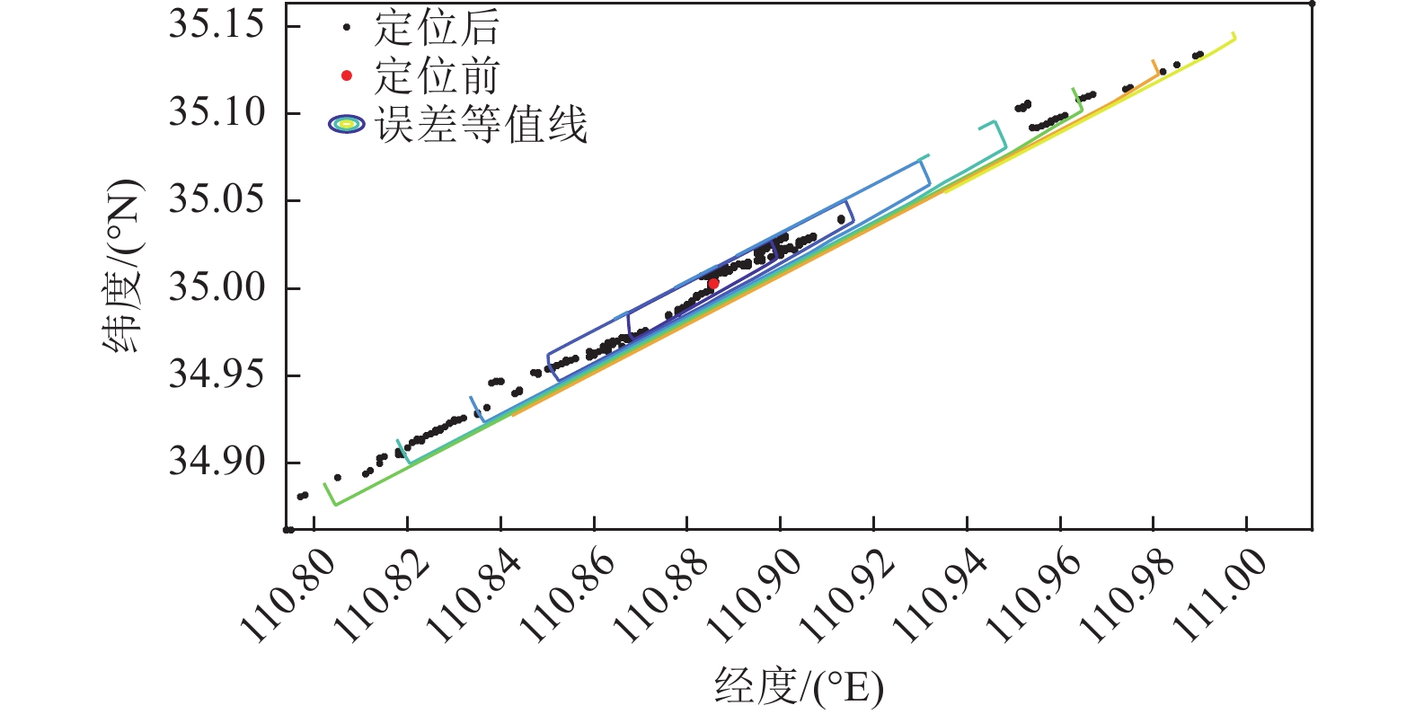
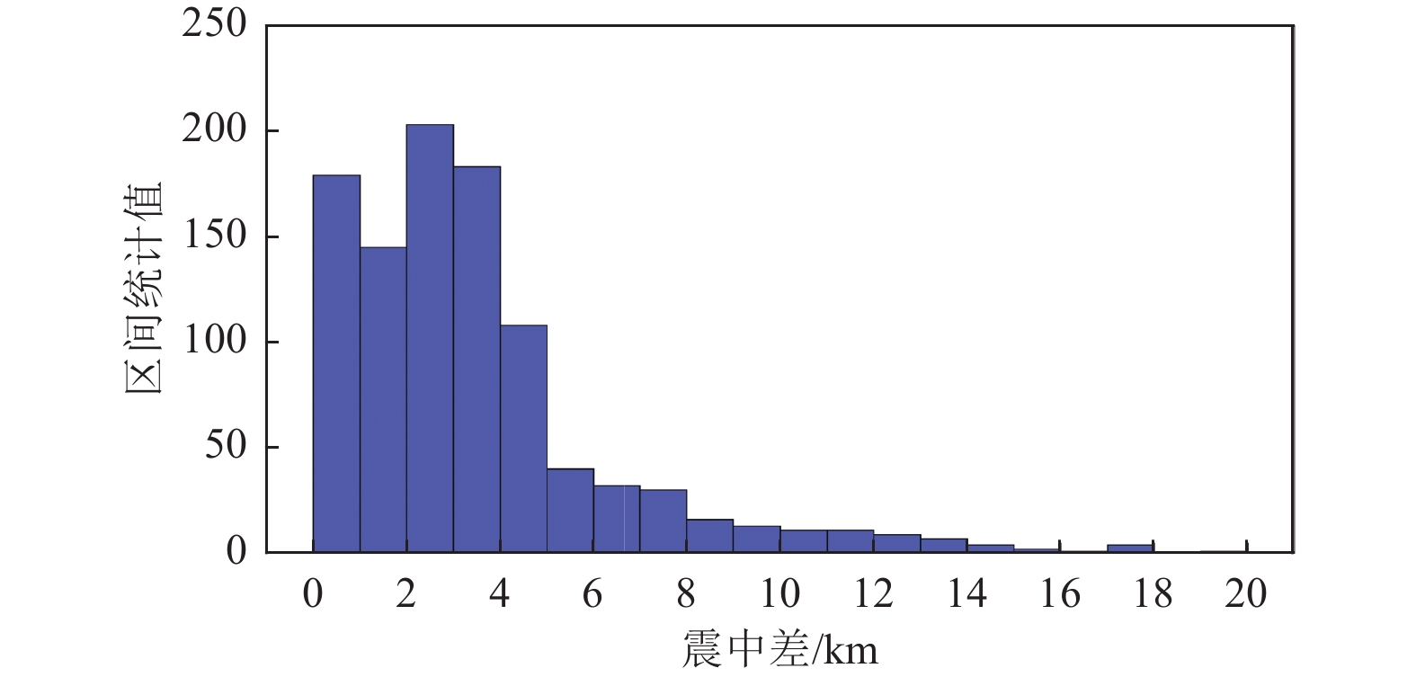
图 5 重新定位前后震中分布对照图
Figure 5. Plot of epicenter distribution before and after relocation
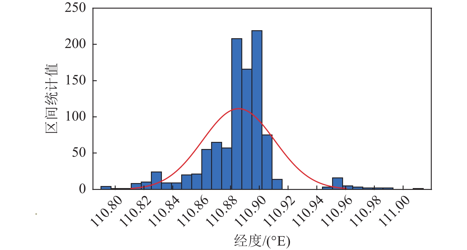
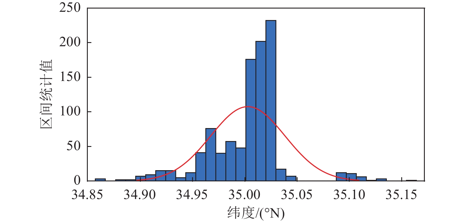
图 7 重定位震中位置经度统计图
Figure 7. Repositioning longitude statistics results of epicenter location
表 1 山西分区模型参数表
Table 1. Parameters of partition model in Shanxi
名称 上地壳P波速度/(km·s−1) 下地壳P波速度/(km·s−1) 莫霍面P波速度/(km·s−1) 康拉德界面深度/km 莫霍界面深度/km 北部模型 6.18 6.72 7.95 21.3 42.9 中部模型 6.15 6.73 7.99 21.0 40.5 南部模型 6.10 6.76 8.03 20.5 38.5  下载: 导出CSV
表 2 测试地震参数表
Table 2. Parameters of tested earthquakes in Shanxi province
序号 发震时刻 纬度/(°N) 经度/(°E) 深度/km 震级ML 地名 1 2010-01-24 10:36:12.1 35.663 110.778 7 5.1 山西河津 2 2010-04-04 21:46:43.1 39.897 113.803 7 4.7 山西大同 3 2010-04-07 15:30:01.5 36.302 111.704 15 4.1 山西洪洞 4 2011-03-07 01:51:35.8 39.025 111.716 10 4.5 山西五寨 5 2011-04-21 00:15:54.4 36.084 112.945 10 3.7 山西长子 6 2011-08-02 19:57:15.0 36.514 112.045 19 4.2 山西古县 7 2011-12-24 14:20:22.5 39.499 112.813 9 3.9 山西山阴 8 2012-09-17 10:43:41.0 37.567 112.368 6 3.8 山西清徐 9 2012-11-02 00:09:44.8 35.952 111.727 5 3.8 山西浮山 10 2012-11-29 08:47:02.7 39.903 113.220 2 3.6 山西怀仁 11 2013-02-22 12:02:03.2 39.891 113.826 8 4.1 山西大同 12 2013-04-04 17:42:24.8 35.338 111.615 14 4.0 山西垣曲 13 2013-07-09 18:39:14.2 38.632 113.019 9 3.6 山西定襄 14 2013-11-12 00:15:37.9 39.284 112.417 14 3.9 山西朔州 15 2014-04-04 23:16:40.2 37.274 112.221 15 4.1 山西平遥 16 2016-03-12 11:14:10.3 35.004 110.882 12 4.8 山西盐湖 17 2016-04-07 04:49:49.1 38.859 112.905 14 4.7 山西原平 18 2016-11-04 03:41:07.9 37.658 113.657 9 3.6 山西昔阳 19 2016-11-18 07:22:57.9 37.713 112.552 18 3.9 山西太原 20 2016-12-18 11:08:50.4 37.610 112.481 18 4.6 山西清徐 21 2017-10-19 09:15:44.2 35.986 111.529 19 3.6 山西尧都 22 2018-03-18 15:15:05.2 36.514 111.795 27 3.9 山西霍州 23 2020-01-06 22:21:25.6 37.470 112.359 20 4.2 山西祁县 24 2021-04-08 03:25:48.0 36.285 111.711 18 3.6 山西洪洞 25 2022-02-20 08:27:27.8 37.954 112.108 4 4.1 山西古交 26 2022-04-29 02:52:24.1 40.631 114.147 5 3.7 山西天镇 27 2022-05-16 23:16:21.0 39.276 113.207 5 3.8 山西繁峙 28 2022-09-03 10:47:07.2 39.861 112.388 3 4.5 山西右玉
下载: 导出CSV
表 3 测试地震定位可信度统计表
Table 3. Parameters of reliability test of earthquake location in Shanxi province
序号 发震时刻 地名 所处位置 定位台数/个 最大空隙角/(°) 95%置信区间 下界/km 上界/km 1 2010-01-24 10:36:12.1 山西河津 运城盆地 29 72.5 4.5609 4.8088 2 2010-04-04 21:46:43.1 山西大同 大同盆地 20 196 4.6258 4.9502 3 2010-04-07 15:30:01.5 山西洪洞 临汾盆地 28 50.6 1.6887 1.8874 4 2011-03-07 01:51:35.8 山西五寨 忻定盆地 31 74.0 4.0989 4.4845 5 2011-04-21 00:15:54.4 山西长子 太行山区 31 93.4 2.2979 2.4638 6 2011-08-02 19:57:15.0 山西古县 临汾盆地 37 46.5 2.7264 3.2637 7 2011-12-24 14:20:22.5 山西山阴 大同盆地 28 58.9 4.0993 4.4661 8 2012-09-17 10:43:41.0 山西清徐 太原盆地 52 38.3 0.6264 0.67589 9 2012-11-02 00:09:44.8 山西浮山 临汾盆地 52 27 2.3402 2.5053 10 2012-11-29 08:47:02.7 山西怀仁 大同盆地 41 50.3 4.5880 4.8363 11 2013-02-22 12:02:03.2 山西大同 大同盆地 56 55.9 4.5456 4.7074 12 2013-04-04 17:42:24.8 山西垣曲 运城盆地 56 43.3 4.3600 4.7298 13 2013-07-09 18:39:14.2 山西定襄 忻定盆地 54 41.8 2.2465 2.3255 14 2013-11-12 00:15:37.9 山西朔州 大同盆地 64 39.6 2.7911 3.1900 15 2014-04-04 23:16:40.2 山西平遥 太原盆地 58 26.3 1.3371 1.5528 16 2016-03-12 11:14:10.3 山西盐湖 运城盆地 49 63.2 3.2968 3.6730 17 2016-04-07 04:49:49.1 山西原平 忻定盆地 70 38.4 0.4432 0.5171 18 2016-11-04 03:41:07.9 山西昔阳 太原盆地 67 86 1.9108 2.1054 19 2016-11-18 07:22:57.9 山西太原 太原盆地 67 24.5 2.6519 2.7688 20 2016-12-18 11:08:50.4 山西清徐 太原盆地 44 31 1.9577 2.1403 21 2017-10-19 09:15:44.2 山西尧都 临汾盆地 50 54.3 1.0130 1.1267 22 2018-03-18 15:15:05.2 山西霍州 临汾盆地 55 41.7 0.9031 1.0014 23 2020-01-06 22:21:25.6 山西祁县 太原盆地 63 28.7 1.0943 1.1152 24 2021-04-08 03:25:48.0 山西洪洞 临汾盆地 65 44.4 1.0666 1.2002 25 2022-02-20 08:27:27.8 山西古交 太原盆地 61 38.1 0.8742 0.8920 26 2022-04-29 02:52:24.1 山西天镇 大同盆地 50 124.9 3.8879 4.3199 27 2022-05-16 23:16:21.0 山西繁峙 忻定盆地 59 39.8 0.9158 0.9390 28 2022-09-03 10:47:07.2 山西右玉 大同盆地 53 80.6 2.1911 2.6276
下载: 导出CSV
-
Bondár I., Myers S. C., Engdahl E. R. 等,2006. 地震台网的震中定位精度判据. 徐志国,译. 世界地震译丛, 37 (4):38−55.Bondár I., Myers S. C., Engdahl E. R., et al., 2006. Epicentre accuracy based on seismic network criteria. Xu Z. G., trans. Translated World Seismology, 37 (4): 38−55. (in Chinese) 黄文辉,吕作勇,康英等,2017. 人工爆破检验区域地震台网地震定位精度. 地震地磁观测与研究,38(2):77−80. doi: 10.3969/j.issn.1003-3246.2017.02.014Huang W. H., Lv Z. Y., Kang Y., et al., 2017. Testing earthquake location accuracy of regional seismic network by artificial explosion. Seismological and Geomagnetic Observation and Research, 38(2): 77−80. (in Chinese) doi: 10.3969/j.issn.1003-3246.2017.02.014 蒋长胜,吴忠良,李宇彤,2008. 首都圈地区“重复地震”及其在区域地震台网定位精度评价中的应用. 地球物理学报,51(3):817−827. doi: 10.3321/j.issn:0001-5733.2008.03.022Jiang C. S., Wu Z. L., Li Y. T., 2008. Estimating the location accuracy of the Beijing Capital Digital Seismograph Network using repeating events. Chinese Journal of Geophysics, 51(3): 817−827. (in Chinese) doi: 10.3321/j.issn:0001-5733.2008.03.022 吕作勇,杨传成,房立华,2014. 广东地震台网近震定位精度的经验性GT准则. 震灾防御技术,9(S):657−664.Lv Z. Y., Yang C. C., Fang L. H., 2014. Empirical ground truth criteria for location accuracy of near earthquake on Guangdong seismic network. Technology for Earthquake Disaster Prevention, 9(S): 657−664. (in Chinese) 宋美琴,郑勇,葛粲等,2012. 山西地震带中小震精确位置及其显示的山西地震构造特征. 地球物理学报,55(2):513−525. doi: 10.6038/j.issn.0001-5733.2012.02.014Song M. Q., Zheng Y., Ge C., et al., 2012. Relocation of small to moderate earthquakes in Shanxi Province and its relation to the seismogenic structures. Chinese Journal of Geophysics, 55(2): 513−525. (in Chinese) doi: 10.6038/j.issn.0001-5733.2012.02.014 王烁帆,倪四道,王伟涛等,2022. 基于背景噪声经验格林函数的地震准确定位精度分析−−以2008年甘肃武都地震为例. 地球物理学报,65(8):2904−2916. doi: 10.6038/cjg2022P0616Wang S. F., Ni S. D., Wang W. T., et al., 2022. Accuracy analysis of locating earthquakes with ambient noise Empirical Green's Functions−A case study of the 2008 Wudu earthquake (Gansu, China). Chinese Journal of Geophysics, 65(8): 2904−2916. (in Chinese) doi: 10.6038/cjg2022P0616 王未来,吴建平,房立华等,2014. 2014年云南鲁甸 M S6.5地震序列的双差定位. 地球物理学报,57(9):3042−3051. doi: 10.6038/cjg20140929Wang W. L., Wu J. P., Fang L. H., et al., 2014. Double difference location of the Ludian M S6.5 earthquake sequences in Yunnan province in 2014. Chinese Journal of Geophysics, 57(9): 3042−3051. (in Chinese) doi: 10.6038/cjg20140929 尹陈,刘鸿,李亚林等,2013. 微地震监测定位精度分析. 地球物理学进展,28(2):800−807. doi: 10.6038/pg20130229Yin C., Liu H., Li Y. L., et al., 2013. The precision analysis of the microseismic location. Progress in Geophysics, 28(2): 800−807. (in Chinese) doi: 10.6038/pg20130229 殷伟伟,雷建设,黄金刚等,2020. 山西断陷带上地幔顶部Pn波速度结构与各向异性成像. 地球物理学报,63(12):4382−4395. doi: 10.6038/cjg2020O0225Yin W. W., Lei J. S., Huang J. G., et al., 2020. Pn velocity and anisotropic uppermost-mantle tomography in and around the Shanxi rift zone. Chinese Journal of Geophysics, 63(12): 4382−4395. (in Chinese) doi: 10.6038/cjg2020O0225 张蕙,朱元清,宋秀琴等,2021. 山西分区地壳速度模型的建立及应用. 大地测量与地球动力学,41(5):448−453.Zhang H., Zhu Y. Q., Song X. Q., et al., 2021. Establishment and application of regional crustal velocity model in Shanxi zone. Journal of Geodesy and Geodynamics, 41(5): 448−453. (in Chinese) 张志斌,金花,王晓飞,2019. 单纯形定位方法在新疆数字地震台网的测定精度分析. 震灾防御技术,14(1):200−209. doi: 10.11899/zzfy20190119Zhang Z. B., Jin H., Wang X. F., 2019. Analysis of precision of the simplex location method in the Xinjiang digital seismic network. Technology for Earthquake Disaster Prevention, 14(1): 200−209. (in Chinese) doi: 10.11899/zzfy20190119 中国地震局监测预报司,2017. 测震学原理与方法. 北京:地震出版社. 朱元清,赵仲和,1997. 提高地震定位精度新方法的研究. 地震地磁观测与研究,18(5):59−67.Zhu Y. Q., Zhao Z. H., 1997. Research on the new method to raise earthquake location accuracy. Seismological and Geomagnetic Observation and Research, 18(5): 59−67. (in Chinese) Bondár I., Yang X., North R. G., et al., 2001. Location calibration data for CTBT monitoring at the Prototype International Data Center. Pure and Applied Geophysics, 158(1-2): 19−34. Hauksson E., Yang W. Z., Shearer P. M., 2012. Waveform relocated earthquake catalog for southern California (1981 to June 2011). Bulletin of the Seismological Society of America, 102(5): 2239−2244. doi: 10.1785/0120120010 Kato A., Obara K., Igarashi T., et al., 2012. Propagation of slow slip leading up to the 2011 MW 9.0 Tohoku-Oki earthquake. Science, 335(6069): 705−708. doi: 10.1126/science.1215141 Rubin A. M., Gillard D., Got J. L., 1999. Streaks of microearthquakes along creeping faults. Nature, 400(6745): 635−641. doi: 10.1038/23196 Rubin A. M., 2002. Aftershocks of microearthquakes as probes of the mechanics of rupture. Journal of Geophysical Research: Solid Earth, 107(B7): 2142. Schaff D. P., Richards P. G., 2004. Repeating seismic events in China. Science, 303(5661): 1176−1178. doi: 10.1126/science.1093422 Schweitzer J., 2001. HYPOSAT-An enhanced routine to locate seismic events. Pure and Applied Geophysics, 158(1-2): 277−289. Shapiro N. M., Campillo M., Stehly L., et al., 2005. High-resolution surface-wave tomography from ambient seismic noise. Science, 307(5715): 1615−1618. doi: 10.1126/science.1108339 Waldhauser F., Ellsworth W. L., 2000. A double-difference earthquake location algorithm: method and application to the northern Hayward fault, California. Bulletin of the Seismological Society of America, 90(6): 1353−1368. doi: 10.1785/0120000006 -


 点击查看大图
计量
- 文章访问数: 238
- HTML全文浏览量: 63
- PDF下载量: 41
- 被引次数: 0
