
Research and Application of Efficient Identification of Slope-Related Geological Hazards in Xi'an City
-
摘要: 为进一步查明西安市斜坡类地质灾害底数,并实现大区域地质灾害高效准确识别,利用航空摄影测量获取了6 004.20 km2西安市地质灾害易发区的高精度实景三维模型,通过构建大区域地质灾害解译工作方法,分类建立适用于实景三维模型的地质灾害解译标志,采用“样区解译+现场核查”的分期次迭代式人机交互方式提高解译正确率,实现了数千平方公里的大区域地质灾害高效准确识别,成功发现新地质灾害点546处,整体解译正确率达到88.35%。在此基础上,结合原有456处斜坡类地质灾害点,考虑区域断裂分布与地震活动背景等影响因素,采用加权信息量法进行了西安市斜坡类地质灾害易发性评价,更新了西安市地质灾害防治基础数据库。进而,讨论了利用实景三维模型进行大区域地质灾害识别的优势与亟待改进的问题,为未来大区域规模化地质灾害高效排查提供了实践参考。Abstract: To further clarify the inventory of slope-type geological disasters in Xi'an and achieve efficient and accurate identification of geological disasters in large areas, high-precision real 3D models covering 6 004.20 km2 of geological disaster-prone areas in Xi'an were obtained via aerial photogrammetry. By constructing a working method for geological disaster interpretation in large areas and establishing classification-based interpretation signs for geological disasters applicable to real 3D models, a phased iterative human-computer interaction mode of "sample area interpretation + field verification" was adopted to improve the interpretation accuracy and realize efficient and accurate identification of geological disasters in a large area of thousands of square kilometers. Eventually, 546 new geological disaster points were successfully identified, with the overall interpretation accuracy reaching 88.35%. On this basis, combined with the original 456 slope-type geological disaster points and considering the influence factors such as regional fault distribution and seismic activity background, the weighted information value method was applied to conduct the susceptibility assessment of slope-type geological disasters in Xi'an, and the basic database for geological disaster prevention and control in Xi'an was updated. Furthermore, the advantages and urgent improvement issues of using 3D models for large-area geological disaster identification were discussed, which provides practical references for the efficient and timely investigation of large-area large-scale geological disasters in the future.
-
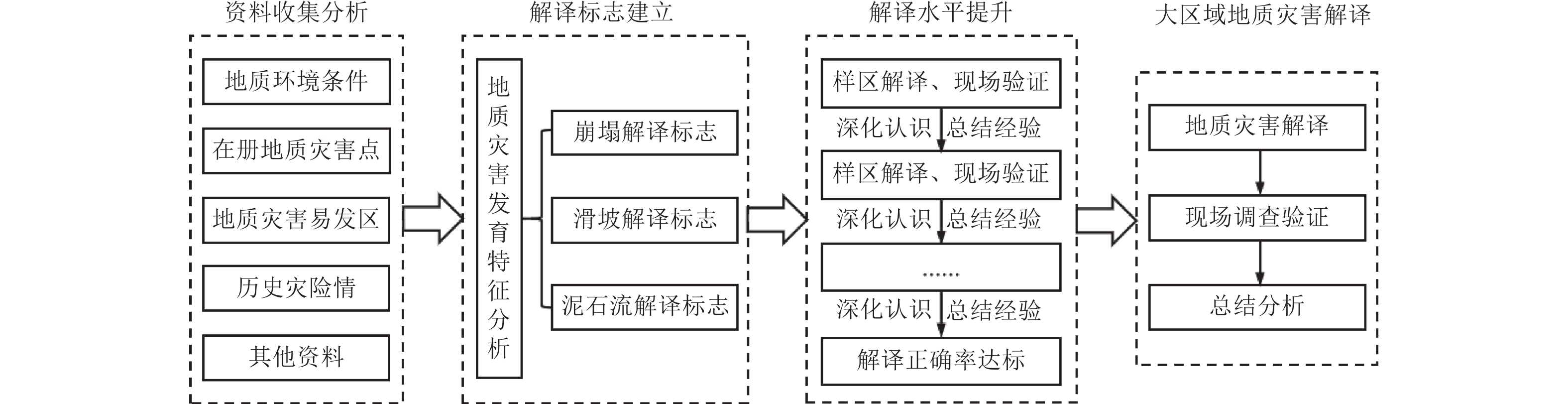
图 2 大区域地质灾害解译工作方法
Figure 2. Methodology for interpreting geological disasters in large areas
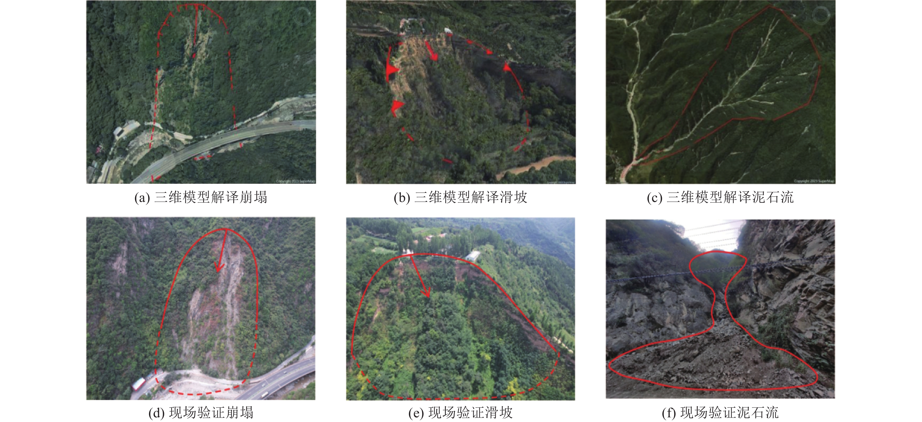
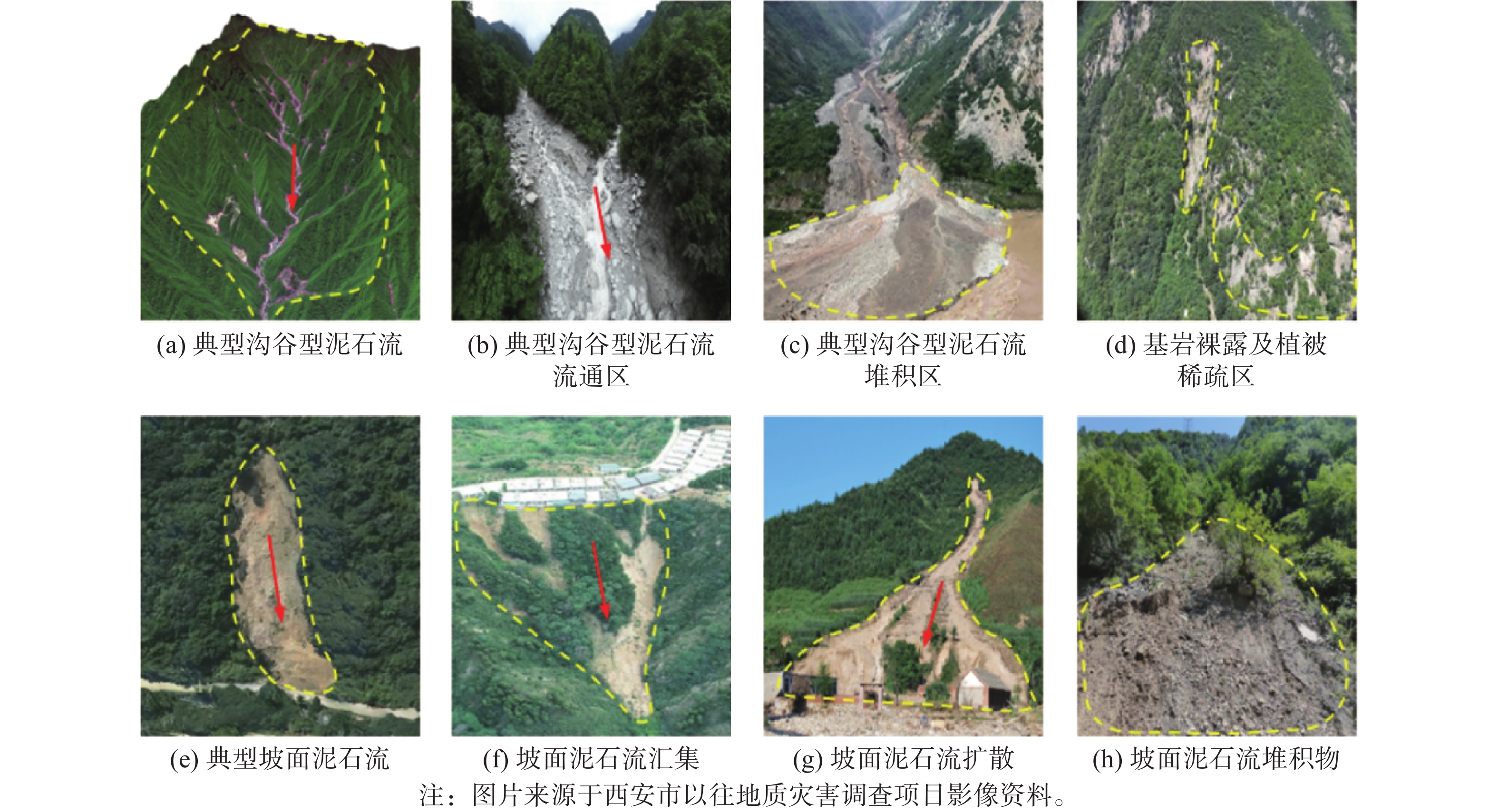
图 6 三维模型解译与现场验证典型对比
Figure 6. Typical comparison between 3D model interpretation and on-site verification
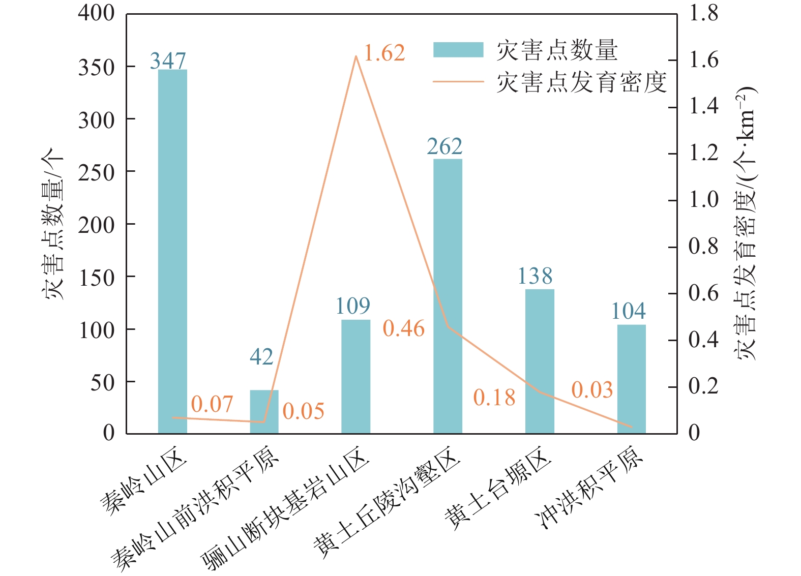
图 10 地质灾害发育特征统计图
Figure 10. Statistical chart of geological disaster development characteristics
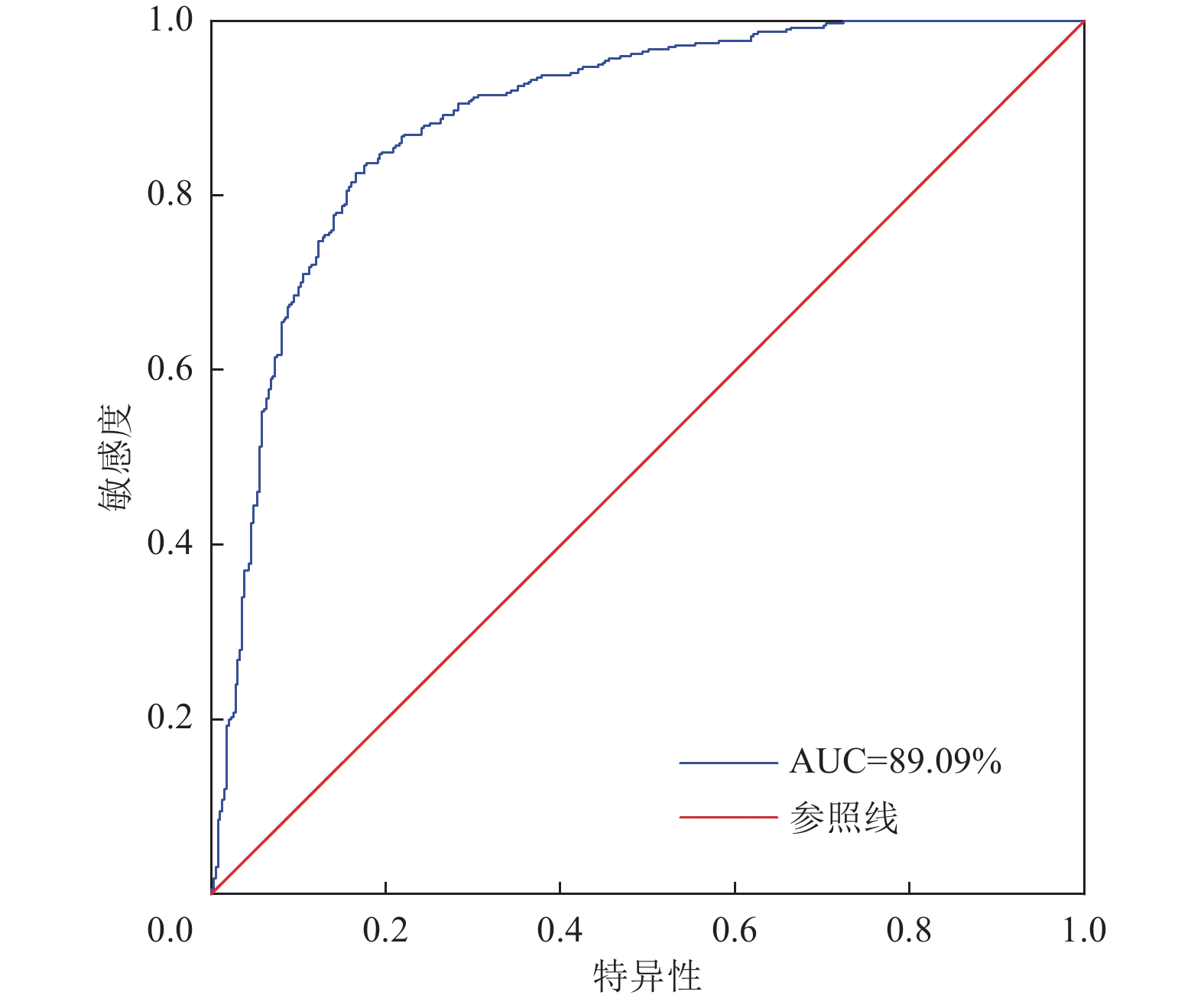
表 1 研究区地质灾害解译成果统计表
Table 1. Statistical table of geological hazard interpretation results in the study area
解译期次 灾害类型 崩塌 滑坡 泥石流 总体解译正确率 新发现地质灾害点/个 正确/总数 正确率 正确/总数 正确率 正确/总数 正确率 第一期 秦岭山区 6/8 75% 5/7 71.43% 6/7 85.71% 84.38% 54 山前洪积平原 2/2 100% 4/4 100% 2/2 100% 黄土地貌区 12/14 85.71% 14/16 87.50% 3/4 75% 第二期 秦岭山区 7/8 87.50% 9/10 90% 4/5 80% 91.42% 64 山前洪积平原 2/3 66.67% 4/4 100% 3/3 100% 黄土地貌区 16/17 94.12% 15/16 93.75% 4/4 100% 第三期 秦岭山区 171/183 93.44% 23/31 74.19% 30/38 78.95% 88.43% 428 山前洪积平原 3/5 60% 49/56 87.50% 0/0 — 黄土地貌区 88/97 90.72% 64/74 86.49% 0/0 — 合计 307/337 91.10% 187/218 85.78 52/63 82.54% 88.35% 546  下载: 导出CSV
表 2 因子权重的配对比较矩阵
Table 2. Pairing comparison matrix of factor weights
评价因子 坡度 坡高 坡型 坡向 岩土体 河流 断裂 道路 归一化植被指数 权重 坡度 1 2 5 3 2 3 2 2 4 0.236 坡高 1/2 1 3 3 3/2 1 2 1 2 0.140 坡型 1/5 1/3 1 1/2 1/3 1/2 1/3 1/3 1/2 0.040 坡向 1/3 1/3 2 1 1/3 1/3 1/2 1/3 1/3 0.047 岩土体 1/2 2/3 3 3 1 2 1 1 2 0.128 河流 1/3 1 2 3 1/2 1 1 1/2 2 0.097 断裂 1/2 1/2 3 2 1 1 1 1 2 0.110 道路 1/2 1 3 3 1 2 1 1 2 0.133 归一化植被指数 1/4 1/2 2 3 1/2 1/2 1/2 1/2 1 0.069
下载: 导出CSV
表 3 评价指标体系及量化分值表
Table 3. Evaluation index system and quantitative score table
评价指标 指标分类 地质灾害点数量/个 信息量 权重 加权信息量 坡度/(°) <10 227 −0.767 0.236 −0.181 10~25 205 0.630 0.149 25~35 162 0.323 0.076 35~50 281 0.296 0.07 >50 127 0.495 0.117 坡高/m 0~10 671 −0.130 0.140 −0.018 10~20 294 0.309 0.043 20~30 34 0.528 0.074 30~40 2 −0.056 −0.008 >40 1 0.637 0.089 坡型 凹形 452 0.502 0.040 0.02 直坡 129 −0.781 −0.031 凸形 421 −0.060 −0.002 坡向/(°) N(337.5~22.5) 75 −1.134 0.047 −0.052 NE(22.5~67.5) 103 −0.137 −0.006 E(67.5~112.5) 158 0.291 0.013 SE(112.5~157.5) 146 0.429 0.02 S(157.5~202.5) 157 0.371 0.017 SW(202.5~247.5) 160 0.559 0.026 W(247.5~292.5) 122 0.031 0.001 NW(292.5~337.5) 81 −0.385 −0.018 岩土体 层状较坚硬-软弱沉积岩 6 −1.446 0.128 −0.185 块状坚硬-较坚硬碳酸岩 78 1.467 0.188 块状坚硬-较坚硬中深变质岩 236 0.039 0.005 块状坚硬侵入岩 202 0.016 0.002 松散粘性碎石土类 480 −0.105 −0.013 距河流距离/m <250 213 0.448 0.097 0.043 250~500 160 0.215 0.021 500~750 128 0.073 0.007 750~ 1000 101 −0.061 −0.006 1000 ~2000257 −0.178 −0.017 >2000 143 −0.352 −0.034 距断裂距离/m <50 23 0.294 0.110 0.032 50~100 25 0.388 0.043 100~300 128 0.672 0.074 300~500 100 0.526 0.058 >500 726 −0.150 −0.017 距道路距离/m <100 135 1.904 0.133 0.253 100~300 143 1.329 0.177 300~500 82 0.853 0.113 500~ 1000 148 0.658 0.088 1000 ~2000199 0.443 0.059 >2000 295 −0.871 −0.116 NDVI 0.011~0.323 16 −1.494 0.069 −0.103 0.323~0.499 97 0.013 0.001 0.499~0.654 329 0.987 0.068 0.654~0.768 417 0.610 0.042 0.768~0.906 143 −1.182 −0.082
下载: 导出CSV
-
董秀军, 邓博, 袁飞云等, 2023. 航空遥感在地质灾害领域的应用: 现状与展望. 武汉大学学报(信息科学版), 48(12): 1897−1913. doi: 10.13203/j.whugis20220151Dong X. J., Deng B., Yuan F. Y., et al., 2023. Application of aerial remote sensing in geological hazards: current situation and prospects. Geomatics and Information Science of Wuhan University, 48(12): 1897−1913. (in Chinese) doi: 10.13203/j.whugis20220151 李一民, 康帅, 董正方等, 2024. 基于TCN的区域RC框架结构地震损伤评估. 震灾防御技术, 19(4): 698−705.Li Y. M., Kang S., Dong Z. F., et al., 2024. Seismic damage assessment of regional RC frame structures based on TCN. Technology for Earthquake Disaster Prevention, 19(4): 698−705. (in Chinese) 刘传正, 陈春利, 2020. 中国地质灾害防治成效与问题对策. 工程地质学报, 28(2): 375−383.Liu C. Z., Chen C. L., 2020. Achievements and countermeasures in risk reduction of geological disasters in China. Journal of Engineering Geology, 28(2): 375−383. (in Chinese) 鲁霞, 兰安军, 母浩江等, 2020. 基于信息量模型的盘州市地质灾害易发性评价. 科学技术与工程, 20(14): 5544−5551.Lu X., Lan A. J., Mu H. J., et al., 2020. Geological hazard risk assessment based on information quantity model in Panzhou City. Science Technology and Engineering, 20(14): 5544−5551. (in Chinese) 苏生瑞, 朱兴国, 刘铁铭, 2022. 西安市地质环境条件与地质灾害研究. 北京: 地质出版社, 36−40. 王俊德, 杜晓阳, 黄天浩等, 2023. 河南省嵩县地质灾害风险评价. 中国地质灾害与防治学报, 34(4): 86−96. doi: 10.16031/j.cnki.issn.1003-8035.202209005Wang J. D., Du X. Y., Huang T. H., et al., 2023. Risk assessment of geological hazards in Song County, Henan Province. The Chinese Journal of Geological Hazard and Control, 34(4): 86−96. (in Chinese) doi: 10.16031/j.cnki.issn.1003-8035.202209005 王鑫, 王鲜, 郝业等, 2023. 基于加权信息量法与综合指数法的西安市蒋村街道地质灾害易发性评价对比. 世界地质, 42(2): 399−408. doi: 10.3969/j.issn.1004-5589.2023.02.018Wang X., Wang X., Hao Y., et al., 2023. Comparison between weighted information and comprehensive index methods on geological disaster susceptibility evaluation at Jiangcun street, Xi'an City. World Geology, 42(2): 399−408. (in Chinese) doi: 10.3969/j.issn.1004-5589.2023.02.018 西安市自然资源和规划局, 西安市发展和改革委员会, 2021. 西安市地质灾害防治“十四五”规划. 西安: 西安市自然资源和规划局, 西安市发展和改革委员会. 谢婉丽, 滕宏泉, 杜蕾等, 2018a. 大西安地区滑坡分类及其特征分析. 地球环境学报, 9(1): 79−88.Xie W. L., Teng H. Q., Du L., et al., 2018a. An analysis of landslide classifications and characteristics in Xi’an. Journal of Earth Environment, 9(1): 79−88. (in Chinese) 谢婉丽, 滕宏泉, 杜蕾等, 2018b. 基于GIS结合模糊信息方法在灾害危险性区划中的应用−−以大西安地区崩滑地质灾害为例. 灾害学, 33(3): 111−116.Xie W. L., Teng H. Q., Du L., et al., 2018b. The application of evaluation method combing fuzzy information with GIS to mapping susceptibility and risk of geological disasters of landslide and collapse in greater Xi’an region. Journal of Catastrophology, 33(3): 111−116. (in Chinese) 许强, 董秀军, 李为乐, 2019. 基于天-空-地一体化的重大地质灾害隐患早期识别与监测预警. 武汉大学学报(信息科学版), 44(7): 957−966.Xu Q., Dong X. J., Li W. L., 2019. Integrated space-air-ground early detection, monitoring and warning system for potential catastrophic geohazards. Geomatics and Information Science of Wuhan University, 44(7): 957−966. (in Chinese) 许强, 陆会燕, 李为乐等, 2022. 滑坡隐患类型与对应识别方法. 武汉大学学报(信息科学版), 47(3): 377−387. doi: 10.13203/j.whugis20210618Xu Q., Lu H. Y., Li W. L., et al., 2022. Types of potential landslide and corresponding identification technologies. Geomatics and Information Science of Wuhan University, 47(3): 377−387. (in Chinese) doi: 10.13203/j.whugis20210618 殷翔, 刘炜, 姚生海等, 2022. 基于无人机测量的微地貌提取−−以昆中断裂(巴隆-温泉段)为例. 震灾防御技术, 17(4): 701−709.Yin X., Liu W., Yao S. H., et al., 2022. Micro landform extraction based on UAV photography technology−taking Kunzhong Fault (Balong Wenquan Section) as an example. Technology for Earthquake Disaster Prevention, 17(4): 701−709. (in Chinese) 殷跃平, 高少华, 2024. 高位远程地质灾害研究: 回顾与展望. 中国地质灾害与防治学报, 35(1): 1−18. doi: 10.16031/j.cnki.issn.1003-8035.202310006Yin Y. P., Gao S. H., 2024. Research on high-altitude and long-runout rockslides: review and prospects. The Chinese Journal of Geological Hazard and Control, 35(1): 1−18. (in Chinese) doi: 10.16031/j.cnki.issn.1003-8035.202310006 张勤, 赵超英, 陈雪蓉, 2022. 多源遥感地质灾害早期识别技术进展与发展趋势. 测绘学报, 51(6): 885−896.Zhang Q., Zhao C. Y., Chen X. R., 2022. Technical progress and development trend of geological hazards early identification with multi-source remote sensing. Acta Geodaetica et Cartographica Sinica, 51(6): 885−896. (in Chinese) 周阳阳, 孙中瑞, 陈斌等, 2024. 基于实景三维模型的地质灾害隐患识别−−以广东省上坪镇为例. 时空信息学报, 31(1): 148−156.Zhou Y. Y., Sun Z. R., Chen B., et al., 2024. Geological hazard hidden danger identification based on real-scene 3D models: A case study of Shangping town, Guangdong Province. Journal of Spatio-Temporal Information, 31(1): 148−156. (in Chinese) -


 点击查看大图

计量
- 文章访问数: 44
- HTML全文浏览量: 22
- PDF下载量: 40
- 被引次数: 0
