
Intelligent Assessment Method for Post-Earthquake Building Damage Driven by Multimodal Data
-
摘要: 震后快速精准的建筑物损毁评估对于应急救援至关重要。本研究针对单一遥感技术在震后评估中存在的局限性,提出了一种融合多模态遥感数据与CatBoost机器学习算法的建筑物损毁分类模型(CatBoost-based multiclass damage model, CMDM)。以2023年受土耳其地震影响的安塔基亚市为研究对象,综合引入雷达干涉相干性、卫星影像的光谱与纹理特征,以及峰值地面加速度等多种特征,构建了针对轻微损毁、严重损毁与完全破坏的三分类评估框架。结果表明,CMDM模型整体分类性能良好,平均F1分数达到0.706,其精度显著优于随机森林和XGBoost模型,验证了多模态特征协同建模可以在复杂城市场景中提升建筑物损毁判别能力,为快速、大范围的灾情研判提供可靠的技术参考。Abstract: Rapid and accurate assessment of building damage after earthquakes is crucial for emergency response. To address the limitations of single remote sensing technology in post-earthquake evaluation, this study proposed a CatBoost-based multiclass damage model (CMDM) that integrated multi-modal remote sensing data with the CatBoost machine learning algorithm. Using Antakya, Turkey, affected by the 2023 earthquake, as the study area, the model incorporated radar interferometric coherence, spectral and texture features from satellite imagery, and peak ground acceleration, among other features, to establish a three-level assessment framework for slight, severe, and complete damage. The results show that the CMDM achieves satisfactory overall classification performance, with an average F1 score of 0.706, significantly outperforming Random Forest and XGBoost models. Multi-modal feature fusion enhances building damage discrimination in complex urban scenarios, providing a reliable approach for rapid, large-scale disaster assessment.
-
Key words:
- Multimodal data fusion /
- SAR /
- Multispectral imagery /
- CatBoost /
- Building damage
-

图 1 基于Sentinel-2号卫星彩色合成影像的研究区域
Figure 1. The study area based on the Sentinel-2 satellite color composite image
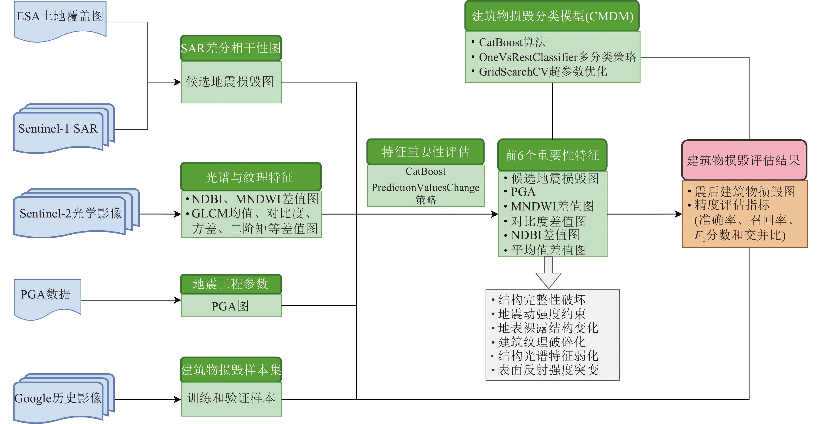
图 2 震后建筑物损毁评估流程图
Figure 2. The flowchart of post-earthquake building damage assessment
表 1 基于CMDM模型的震后建筑物损毁准确性评估
Table 1. Accuracy assessment of post-earthquake building damage based on CMDM model
损毁等级 P R F1 I 轻微损毁 0.580 0.695 0.626 0.455 严重损毁 0.733 0.660 0.695 0.532 完全破坏 0.768 0.826 0.796 0.661 平均值 0.693 0.727 0.706 0.549  下载: 导出CSV
表 2 基于随机森林的震后建筑物损毁准确性评估
Table 2. Accuracy evaluation of post-earthquake building damage based on random forest
损毁等级 P R F1 I 轻微损毁 0.509 0.611 0.555 0.384 严重损毁 0.747 0.650 0.695 0.533 完全破坏 0.755 0.804 0.779 0.638 平均值 0.670 0.688 0.676 0.518
下载: 导出CSV
表 3 基于XGBoost的震后建筑物损毁准确性评估
Table 3. Accuracy evaluation of post-earthquake building damage based on XGBoost
损毁等级 P R F1 I 轻微损毁 0.581 0.568 0.574 0.403 严重损毁 0.733 0.630 0.677 0.512 完全破坏 0.760 0.793 0.777 0.635 平均值 0.691 0.664 0.676 0.517
下载: 导出CSV
-
贺宁波, 焦永春, 王向鹏等, 2025. 基于贝叶斯优化的CatBoost算法自动识别隧道微地震信号. 成都理工大学学报(自然科学版), 52(6): 1230−1245. doi: 10.12474/cdlgzrkx.2025090302He N. B., Jiao Y. C., Wang X. P., et al., 2025. CatBoost algorithm based on Bayesian optimization for the automatic identification of microseismic signals in tunnels. Journal of Chengdu University of Technology (Science & Technology Edition), 52(6): 1230−1245. (in Chinese) doi: 10.12474/cdlgzrkx.2025090302 刘海辉, 2024. 基于Sentinel−1时序相干性的地震损毁建筑物识别研究. 西安: 长安大学.Liu H. H., 2024. Research on identification of earthquake-damaged buildings based on Sentinel-1 temporal coherence. Xi’an: Chang’an University. (in Chinese) 任辰昊, 杜一鹏, 史庆轩等, 2025. 西藏定日6.8级地震拉孜县Ⅶ度区建筑震害调查与分析. 震灾防御技术, 20(2): 243−253.Ren C. H., Du Y. P., Shi Q. X., et al., 2025. Investigation and analysis of building seismic damages in the seismic intensity VII area in Lazi County caused by Ms6.8 Dingri earthquake. Technology for Earthquake Disaster Prevention, 20(2): 243−253. (in Chinese) 肖本夫, 张露露, 陈波等, 2023. 四川泸县Ms6.0地震极震区无人机影像震害分析. 震灾防御技术, 18(2): 301−308.Xiao B. F., Zhang L. L., Chen B., et al., 2023. Seismic damage analysis of UAV remote sensing images in the extreme seismic zone of the MS6.0 earthquake in Luxian, Sichuan. Technology for Earthquake Disaster Prevention, 18(2): 301−308. (in Chinese) Buyuksarac A., Bektaş Ö., Işık E., et al., 2023. Investigation of site characterization and vulnerability in Antakya (Turkey) under basin effect. Erzincan Ü niversitesi Fen Bilimleri Enstitüsü Dergisi, 16(2): 548−570. doi: 10.18185/erzifbed.1087462 Hajeb M., Karimzadeh S., Matsuoka M., 2020. SAR and LIDAR datasets for building damage evaluation based on support vector machine and random forest algorithms−a case study of Kumamoto earthquake, Japan. Applied Sciences, 10(24): 8932. doi: 10.3390/app10248932 Hancock J. T., Khoshgoftaar T. M., 2020. CatBoost for big data: an interdisciplinary review. Journal of Big Data, 7(1): 94. doi: 10.1186/s40537-020-00369-8 Kim M., Park S. E., Lee S. J., 2023. Detection of damaged buildings using temporal SAR data with different observation modes. Remote Sensing, 15(2): 308. doi: 10.3390/rs15020308 Prokhorenkova L., Gusev G., Vorobev A., et al., 2018. CatBoost: unbiased boosting with categorical features. In: Proceedings of the 32nd International Conference on Neural Information Processing Systems. Montréal: Curran Associates Inc., 6639−6649. Wang J., Fan X. W., Qi Y. M., et al., 2025. Building damage detection from multi-feature fusion of Sentinel-1/2 imagery using variational autoencoder and MLP-Mixer network: insights from the Jishishan earthquake. Big Earth Data, 1−40. [2025-12-21]. https://www.tandfonline.com/doi/full/ 10.1080/20964471.2025.2597590. DOI: 10.1080/20964471.2025.2597590. Yu, X., Hu, X., Song, Y. Q., et al., 2024. Intelligent assessment of building damage of 2023 Turkey−Syria Earthquake by multiple remote sensing approaches. npj Natural Hazards, 1(1): 3. doi: 10.1038/s44304-024-00003-0 Zhao W. D., Li S. S., Li A., et al., 2019. Hyperspectral images classification with convolutional neural network and textural feature using limited training samples. Remote Sensing Letters, 10(5): 449−458. doi: 10.1080/2150704X.2019.1569274 -


 点击查看大图
计量
- 文章访问数: 22
- HTML全文浏览量: 10
- PDF下载量: 6
- 被引次数: 0
