
Susceptibility Assessment of Geo-Hazards in Southern China Using an Automated Machine Learning-Optimized Random Forest
-
摘要: 中国南方地区(海南、广东、广西、贵州、云南)地质环境复杂,地质灾害高发,亟需开展高精度区域易发性评估。本研究基于58 037处地质灾害隐患点,系统选取高程、土地利用、与河流/断层距离等12类因子,提出一种结合FLAML自动机器学习框架与随机森林的高效易发性评估方法。自动化超参数寻优显著提升模型性能并克服传统模型依赖人工调参的局限。结果显示,模型在训练集与测试集上的AUC分别为0.739和0.719,召回率均超过0.67,具备良好的预测精度与泛化能力。因子重要性分析表明,高程、土地利用和与河流距离是主导控制因子。空间分区结果显示,高及较高易发区仅占24.82%的面积,却包含55.95%的隐患点,空间合理性显著。本研究首次利用100 m分辨率栅格实现南方五省全域精细化易发性区划,为大尺度地质灾害易发性评估提供了一种高效、精准的技术范式,可为工程选址与风险管控提供科学支撑。Abstract: The Southern China (Hainan, Guangdong, Guangxi, Guizhou, and Yunnan) exhibit complex geological settings and frequent geo-hazards, necessitating accurate regional susceptibility assessment. Using 58,037 geo-hazard potential points and twelve carefully selected conditioning factors—including elevation, land-use type, and distances to rivers and faults—this study develops a high-precision susceptibility assessment model by integrating the FLAML automated machine-learning framework with Random Forest. The automated hyperparameter optimization effectively overcomes the limitations of manually tuned models and enhances prediction performance. The proposed model achieves AUC values of 0.739 and 0.719 for the training and testing sets, respectively, with recall values exceeding 0.67, demonstrating strong predictive accuracy and generalization capability. Feature-importance analysis identifies elevation, land use, and distance to rivers as the dominant controlling factors. Spatial results show that high and moderately high susceptibility zones account for only 24.82% of the total area but contain 55.95% of hazard points, confirming strong spatial consistency. This study is the first to produce 100-m-resolution susceptibility zoning across all five southern provinces, establishing an efficient and accurate methodological paradigm for large-scale geo-hazard susceptibility assessment and supporting major engineering site selection and regional risk management.
-

图 2 本研究中建模所用的12个地质灾害隐患点影响因子
Figure 2. Twelve influencing factors of geological disaster hidden danger points used for modeling in this study
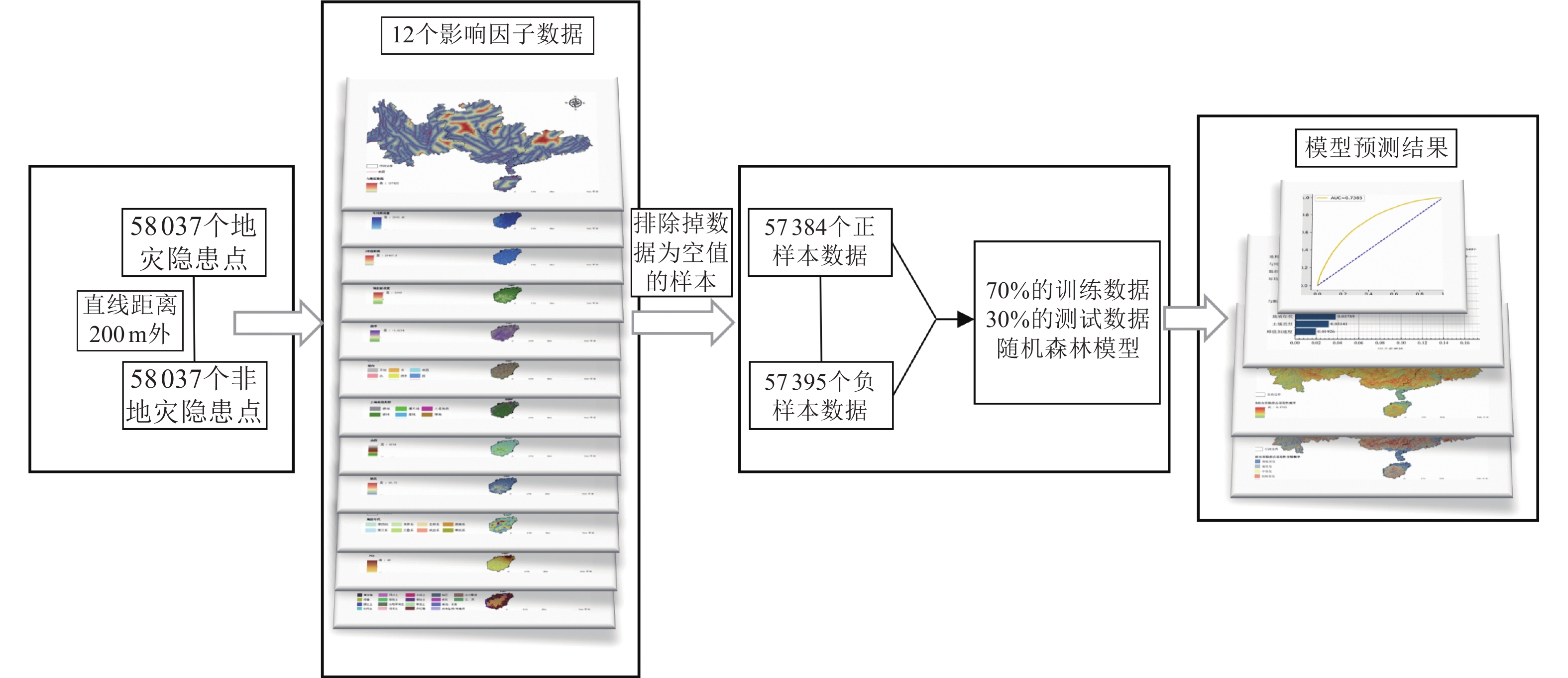
图 4 南方地区地质灾害隐患点易发性模型绘制流程图
Figure 4. Flow chart for mapping the susceptibility model of geological disaster hidden danger points in Southern China
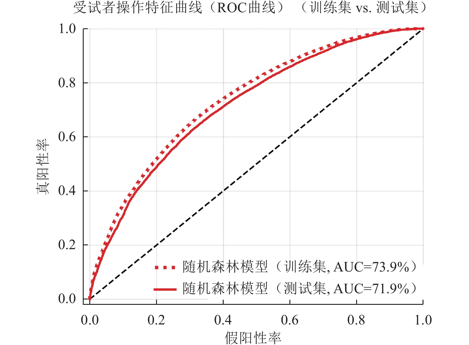
图 6 本研究模型ROC曲线
Figure 6. ROC curve and AUC value derived from the modeling in this study
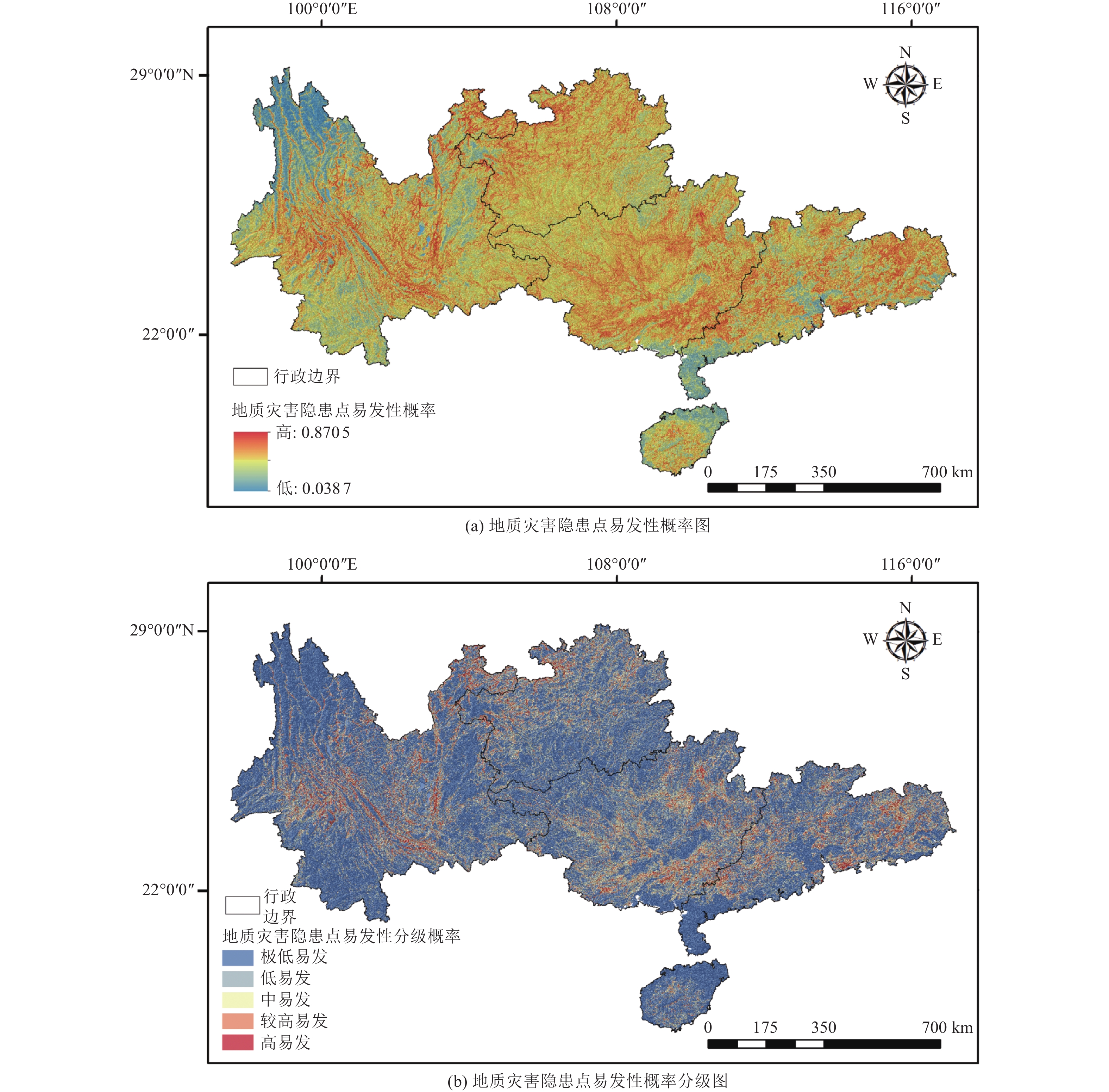
图 8 南方地区地质灾害隐患点易发性概率结果
Figure 8. Susceptibility probability results of geological disaster hidden danger points in Southern China
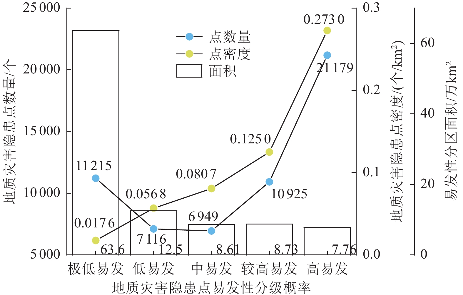
图 9 不同易发性分区的统计以及详细数据
Figure 9. Statistics and detailed data of different susceptibility zoning areas
表 1 随机森林模型训练集与测试集分类性能指标
Table 1. Classification performance metrics of random forest model on training and test datasets
集合 模型性能指标 精确率/% 召回率/% 准确率/% F1分数/% AUC值/% 训练集 67.30 68.34 67.50 67.82 73.90 测试集 65.28 67.03 65.87 66.14 71.90  下载: 导出CSV
-
郭飞, 赖鹏, 黄发明等, 2024. 基于知识图谱的滑坡易发性评价文献综述及研究进展. 地球科学, 49(5): 1584−1606.Guo F., Lai P., Huang F. M., et al., 2024. Literature review and research progress of landslide susceptibility mapping based on knowledge graph. Earth Science, 49(5): 1584−1606. (in Chinese) 黄发明, 汪洋, 董志良等, 2019. 基于灰色关联度模型的区域滑坡敏感性评价. 地球科学, 44(2): 664−676.Huang F. M., Wang Y., Dong Z. L., et al., 2019. Regional landslide susceptibility mapping based on grey relational degree model. Earth Science, 44(2): 664−676. (in Chinese) 李晨阳, 王新春, 何春珍等, 2019. 全国1∶200000数字地质图(公开版)空间数据库. 中国地质, 46(S1): 1−10.Li C. Y., Wang X. C., He C. Z., et al., 2019. China national digital geological map (public version at 1: 200 000 scale) spatial database. Geology in China, 46(S1): 1−10. (in Chinese) 李远远, 梅红波, 任晓杰等, 2018. 基于确定性系数和支持向量机的地质灾害易发性评价. 地球信息科学学报, 20(12): 1699−1709.Li Y. Y., Mei H. B., Ren X. J., et al., 2018. Geological disaster susceptibility evaluation based on certainty factor and support vector machine. Journal of Geo-Information Science, 20(12): 1699−1709. (in Chinese) 南燕云, 李亦纲, 李永强等, 2021. 云南巧家MS5.0地震灾害特点与减灾对策分析. 震灾防御技术, 16(4): 750−755.Nan Y. Y., Li Y. G., Li Y. Q., et al., 2021. Analysis on characteristics and countermeasures of Qiaojia MS5.0 earthquake in Yunnan Province. Technology for Earthquake Disaster Prevention, 16(4): 750−755. (in Chinese) 帅向华, 姜立新, 侯建盛等, 2014. 云南鲁甸6.5级地震灾害特点浅析. 震灾防御技术, 9(3): 340−358.Shuai X. H., Jiang L. X., Hou J. S., et al., 2014. Hazard analysis on the characteristics of the M6.5 Ludian earthquake. Technology for Earthquake Disaster Prevention, 9(3): 340−358. (in Chinese) 铁永波, 孙强, 徐勇等, 2022. 南方山地丘陵区典型地质灾害成因机制与风险评价. 中国地质调查, 9(4): 1−9.Tie Y. B., Sun Q., Xu Y., et al., 2022. Genetic mechanism and risk assessment of typical geological hazards in mountainous and hilly areas of South China. Geological Survey of China, 9(4): 1−9. (in Chinese) 吴润泽, 胡旭东, 梅红波等, 2021. 基于随机森林的滑坡空间易发性评价: 以三峡库区湖北段为例. 地球科学, 46(1): 321−330.Wu R. Z., Hu X. D., Mei H. M., et al., 2021. Spatial susceptibility assessment of landslides based on random forest: a case study from Hubei section in the Three Gorges Reservoir area. Earth Science, 46(1): 321−330. (in Chinese) 许冲, 戴福初, 姚鑫等, 2009. GIS支持下基于层次分析法的汶川地震区滑坡易发性评价. 岩石力学与工程学报, 28(S2): 3978−3985.Xu C., Dai F. C., Yao X., et al., 2009. GIS-based landslide susceptibility assessment using analytical hierarchy process in Wenchuan earthquake region. Chinese Journal of Rock Mechanics and Engineering, 28(S2): 3978−3985. (in Chinese) 许冲, 代克滨, 薛智文等, 2025a. 中国月尺度降雨型滑坡发生概率研究. 地质力学学报, 31(5): 960−971.Xu C., Dai K. B., Xue Z. W., et al., 2025a. Probabilistic study of rainfall-induced landslides at a monthly scale in China. Journal of Geomechanics, 31(5): 960−971. (in Chinese) 许冲, 高明星, 薛智文等, 2025b. 专栏评论: 高新技术赋能地震与地质灾害防治研究进展. 地质科技通报, 44(4): 16−22. doi: 10.19509/j.cnki.dzkq.tb20250004Xu C., Gao M. X., Xue Z. W., et al., 2025b. Column review: advancements in earthquake and geological disaster mitigation empowered by advanced technologies. Bulletin of Geological Science and Technology, 44(4): 16−22. (in Chinese) doi: 10.19509/j.cnki.dzkq.tb20250004 叶天竺, 黄崇轲, 邓志奇, 2017.1∶250万中华人民共和国数字地质图空间数据库. 中国地质, 44(S1): 19−24, 139−146.Ye T. Z. , Huang C. K. , Deng Z. Q. , 2017. Spatial database of 1: 2500000 digital geologic map of People's Republic of China. Geology in China, 44(S1): 19−24, 139−146. (in Chinese) 张钟远, 邓明国, 徐世光等, 2022. 镇康县滑坡易发性评价模型对比研究. 岩石力学与工程学报, 41(1): 157−171. doi: 10.13722/j.cnki.jrme.2021.0360Zhang Z. Y., Deng M. G., Xu S. G., et al., 2022. Comparison of landslide susceptibility assessment models in Zhenkang County, Yunnan Province, China. Chinese Journal of Rock Mechanics and Engineering, 41(1): 157−171. (in Chinese) doi: 10.13722/j.cnki.jrme.2021.0360 Breiman L., 2001. Random forests. Machine Learning, 45(1): 5−32. doi: 10.1023/A:1010933404324 Gao H. R. , Xu C. , Wu S. E. , et al. , 2025. Has the unpredictability of geological disasters been increased by global warming? npj Natural Hazards, 2(1): 55. Shen Z. H., Yong B., Gourley J. J., et al., 2020. Recent global performance of the Climate Hazards group Infrared Precipitation (CHIRP) with Stations (CHIRPS). Journal of Hydrology, 591: 125284. doi: 10.1016/j.jhydrol.2020.125284 Xie C. C., Xu C., Huang Y. D., et al., 2025a. Advances in the study of natural disasters induced by the "23.7" extreme rainfall event in North China. Natural Hazards Research, 5(1): 1−13. doi: 10.1016/j.nhres.2025.01.003 Xie C. C., Xu C., Xu X. W., et al., 2025b. Analysis of a comprehensive inventory of rainfall-induced landslides and multi-factor coupling mechanisms in eastern Guangdong, China, in August 2018. Environmental Earth Sciences, 84(24): 707. doi: 10.1007/s12665-025-12726-y Xu X. W., Kang W. J., Wang T., et al., 2025. The MW7.7 Myanmar earthquake: a continental longest surface-rupturing supershear cascading event. npj Natural Hazards, 2(1): 73. doi: 10.1038/s44304-025-00125-z -

 点击查看大图
计量
- 文章访问数: 44
- HTML全文浏览量: 23
- PDF下载量: 47
- 被引次数: 0
