
Cross-Regional Automatic Landslide Identification Research Based on Adaptive Attention U-Net Model
-
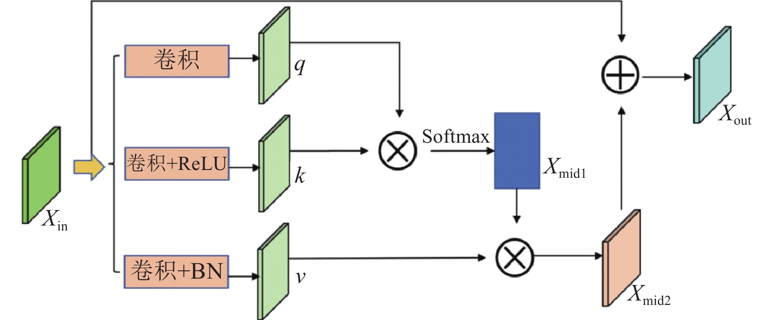
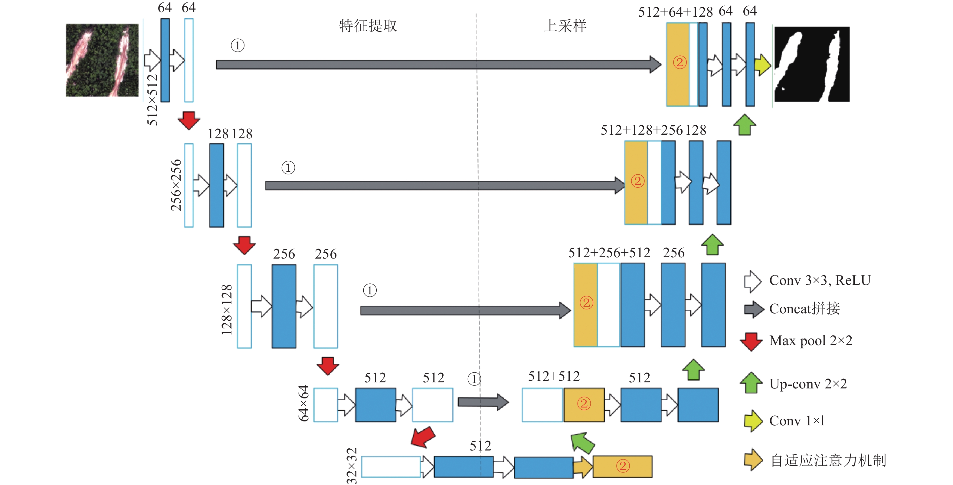
摘要: 滑坡的发生往往会伴随着严重的财产损失和人员伤亡。因此,快速准确的识别滑坡发生位置对于滑坡损失评估和应急救援工作至关重要。近年来,基于卷积神经网络的滑坡自动识别已得到广泛研究,但仍存在由于形状多样且不规则识别完整性差、以及不同区域滑坡自动识别泛化性能差的问题。本文基于九寨沟震区的Planet卫星影像以及地形数据,提出自适应注意力机制的U-Net网络(Adaptively Attention U-Net, AA-UNet)用于识别滑坡,自适应注意力机制可以保证滑坡的完整性。结果表明,AA-UNet模型与现有模型相比,mIoU、F1、OA和Kappa系数更高,分别为90.01%、95.34、97.62%和89.26,证明本文方法在保证滑坡完整性方面的有效性。此外,通过迁移学习策略,AA-UNet模型在3种分辨率的数据集上使用直接迁移和10%样本微调的方法均表现出最佳性能,展现了其在跨区域滑坡检测中的强大泛化能力和鲁棒性。本研究不仅在理论上验证了AA-UNet模型在滑坡识别中的有效性和泛化能力,也为实际应用中跨区域滑坡检测提供了技术支持和实践指导,具有重要的理论意义和应用价值。Abstract: Landslides often result in serious property damage and casualties. Therefore, quickly and accurately identifying the location of landslides is crucial for supporting landslide loss assessment and emergency rescue work. In recent years, a large amount of research has been conducted on the automatic recognition of landslides based on convolutional neural networks. However, landslides still suffer from problems such as poor recognition integrity due to their diverse and irregular shapes, as well as poor generalization performance in automatic recognition of landslides in different regions. Based on Planet satellite images and terrain data of the Jiuzhaigou earthquake zone, this paper proposes an Adaptive Attention U-Net (AA-UNet) network with adaptive attention mechanism for automatic recognition of landslides. The adaptive attention mechanism can ensure the integrity of landslides. The experimental results show that the AA-UNet model achieves the highest mIoU, F1, OA, and Kappa coefficients compared to existing models, with values of 90.01%, 95.34, 97.62% and 89.26, respectively, proving the effectiveness of the proposed method in ensuring landslide integrity. Moreover, through transfer learning strategies, the AA-UNet model showed the best performance in both direct transfer and fine-tuning using only 10% of the samples in the Luding region, demonstrating its strong generalization ability and robustness in cross regional landslide detection. This study not only theoretically verifies the effectiveness and generalization ability of the AA-UNet model in landslide identification, but also provides technical support and practical guidance for cross regional landslide detection in practical applications, which has important theoretical significance and application value.
-
Key words:
- Landslide /
- Recognition /
- Deep Learning /
- U-Net model /
- Transfer Learning
-
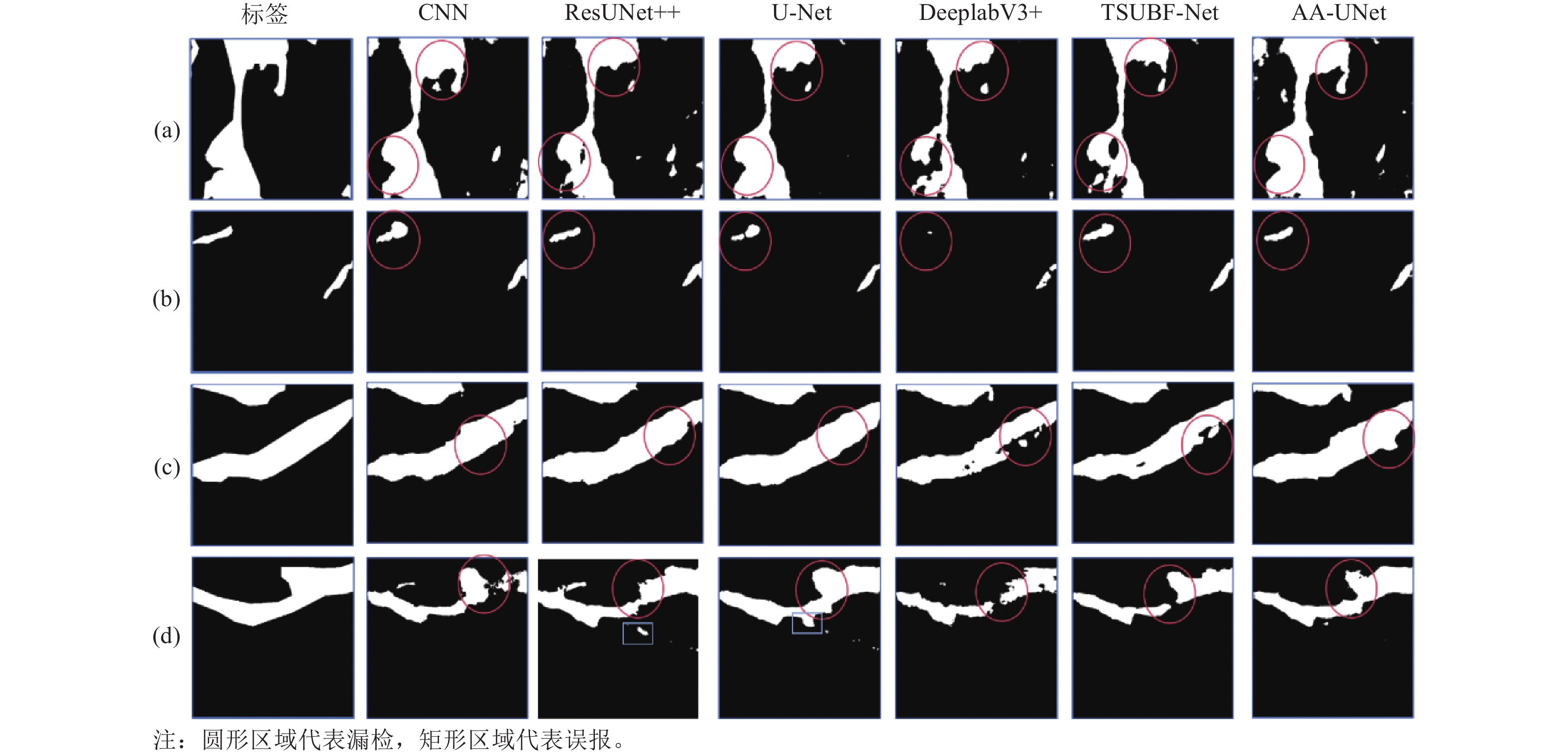
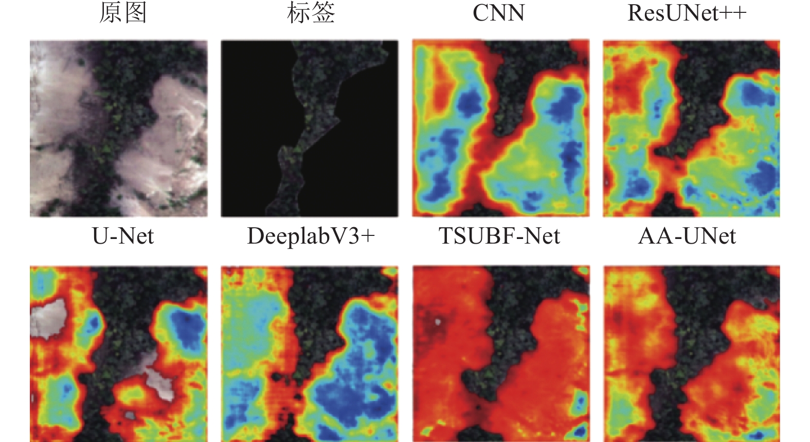
图 5 不同模型的滑坡分割结果示例
Figure 5. Examples of landslide segmentation results from different models
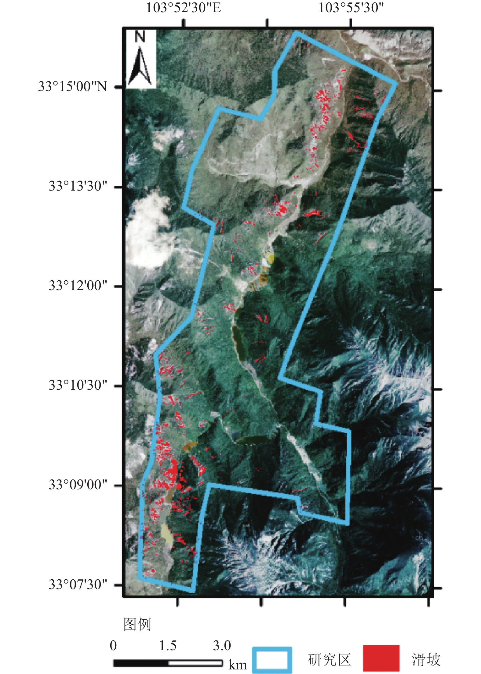
图 6 九寨沟震区AA-UNet模型的识别结果
Figure 6. Identification results of AA-UNet model in Jiuzhaigou valley
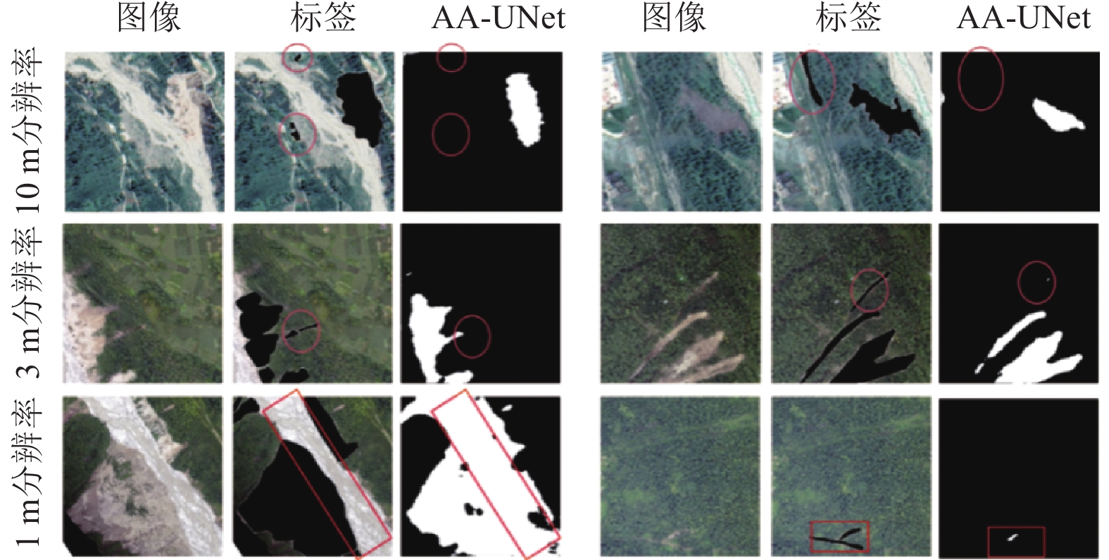
图 8 泸定震区跨域误差分析与失败案例
Figure 8. Cross-domain error analysis and failure cases in the Luding area
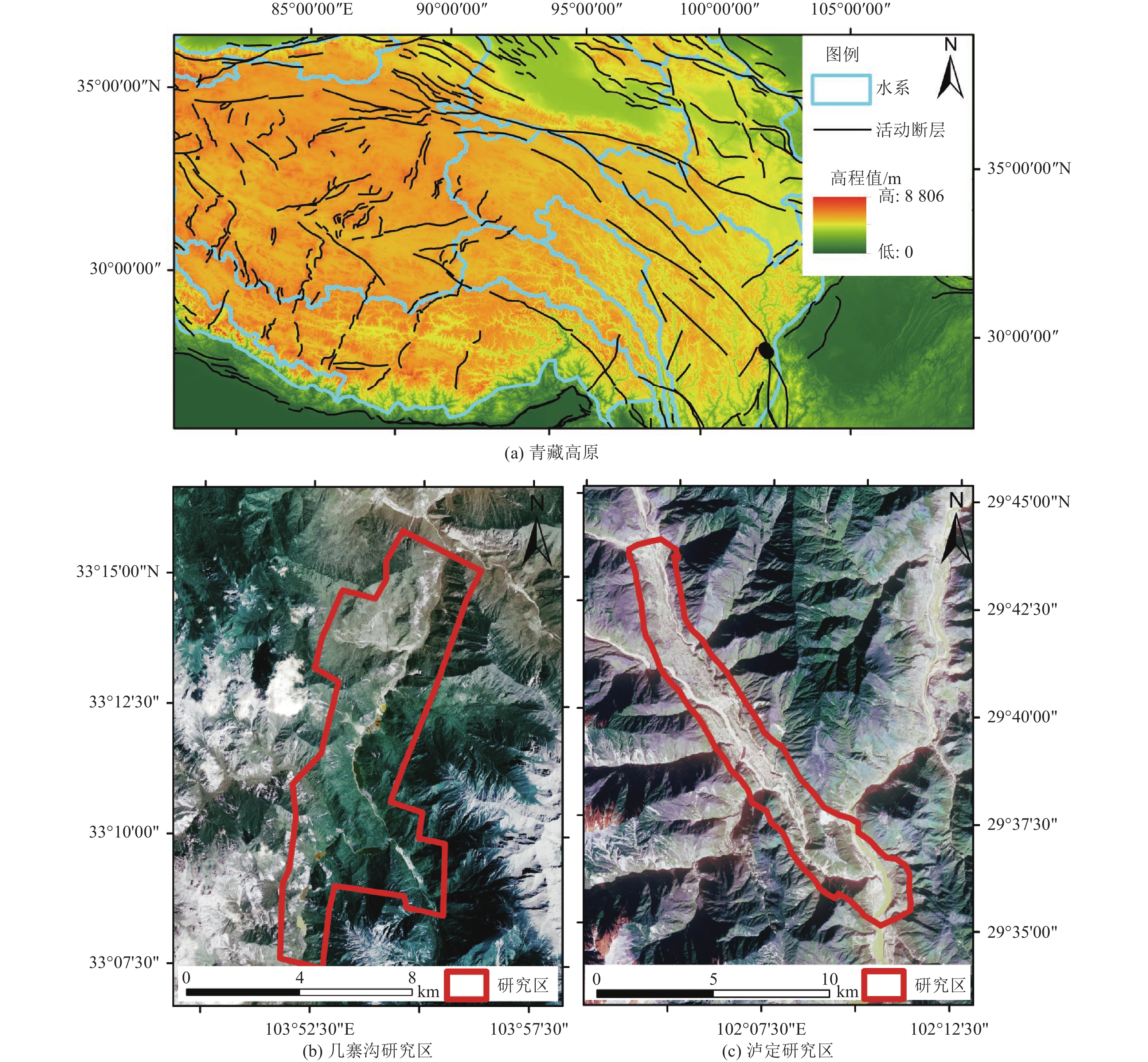
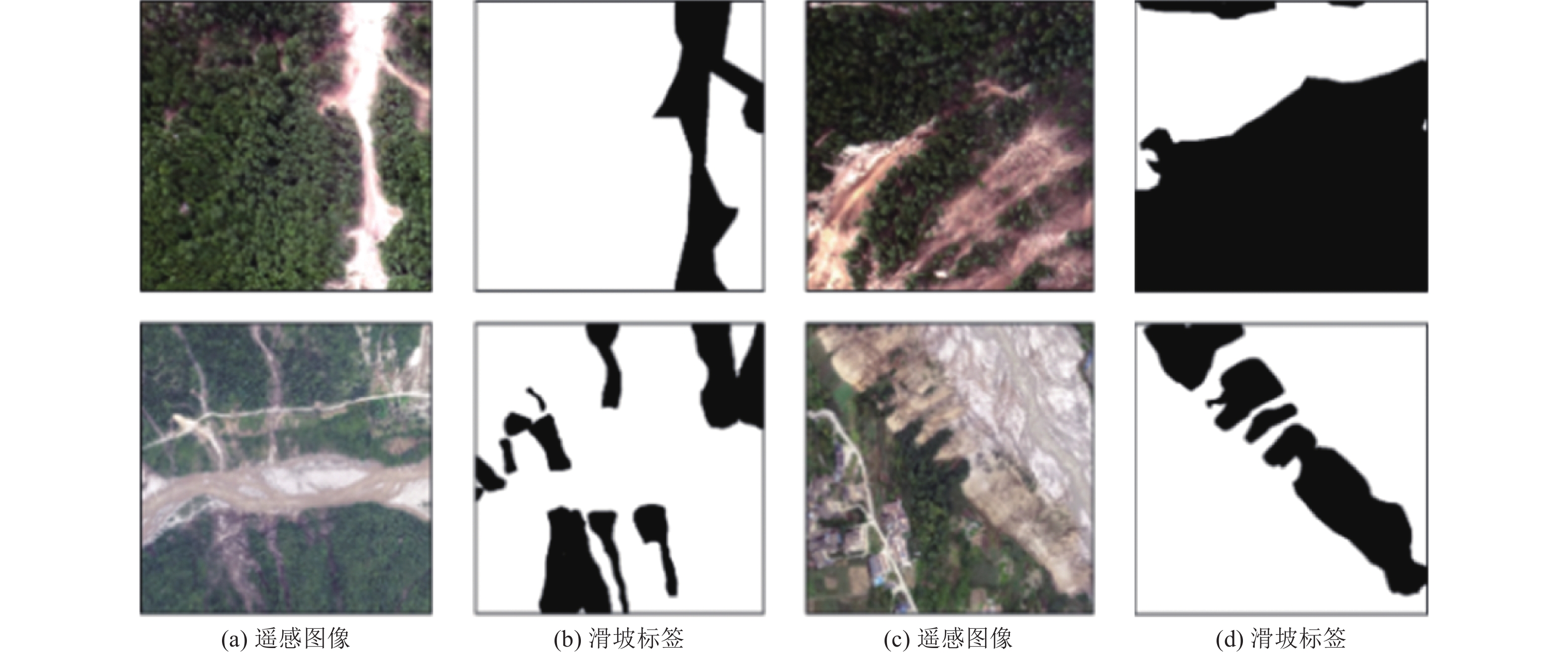
表 1 研究区数据详细情况
Table 1. Detailed data of the study area
研究区 采集时间 传感器 分辨率/m 九寨沟 2017-10-05 Planet 3 泸定 2022-09—2022-10 无人机 1 2022-10-20 Planet 3 2022-09—2022-10 Sentinel-2 10  下载: 导出CSV
表 2 不同模型的定量评估结果
Table 2. Quantitative evaluation results of different models
模型 准确率 召回率 mIoU F1 OA Kappa CNN 89.24 92.37 83.74 90.72 95.83 81.44 ResUNet++ 89.70 90.64 82.91 90.16 95.7 80.32 U-Net 90.52 89.39 86.15 92.60 96.78 85.18 DeeplabV3+ 92.45 91.30 87.30 93.54 97.01 87.56 TSUBF-Net 94.77 87.96 84.21 90.98 96.40 81.98 AA-UNet 95.08 93.26 90.01 95.34 97.62 89.26 注:加黑数值表示该列最好的结果。
下载: 导出CSV
表 3 泸定区域精度评价
Table 3. Accuracy evaluation of Luding region
数据集 模型 mIoU/% F1 准确率/ % 召回率/ % 1 CNN 48.32 58.14 56.21 60.33 ResUNet++ 53.15 63.28 62.40 64.18 U-Net 51.74 61.47 59.27 63.85 DeeplabV3++ 46.45 54.21 59.18 50.01 TSUBF-Net 55.86 65.92 66.33 65.50 AA-UNet 60.17 69.99 71.54 68.50 2 CNN 50.15 61.85 59.45 64.40 ResUNet++ 53.90 65.30 64.55 66.08 U-Net 50.72 62.40 60.17 64.80 DeeplabV3++ 55.88 68.05 65.16 71.21 TSUBF-Net 56.45 67.33 64.20 72.75 AA-UNet 57.69 68.39 68.68 68.11 3 CNN 51.80 64.95 60.10 70.50 ResUNet++ 54.85 66.95 64.80 69.20 U-Net 52.20 65.71 60.77 71.52 DeeplabV3++ 56.70 67.23 65.02 69.60 TSUBF-Net 53.30 65.02 62.18 68.15 AA-UNet 58.53 68.36 69.14 67.60 注:加黑数值表示该列最好的结果。
下载: 导出CSV
表 4 泸定区域迁移学习的精度评价
Table 4. Accuracy evaluation of transfer learning in Luding region
数据集 模型 mIoU /% F1 准确率/ % 召回率/ % 1 CNN 59.25 71.03 70.12 71.95 ResUNet++ 68.40 78.91 80.05 77.80 U-Net 65.18 75.51 78.92 72.38 DeeplabV3+ 71.20 80.92 81.15 80.70 TSUBF-Net 73.55 82.47 84.33 81.65 AA-UNet 76.81 86.36 93.58 80.17 2 CNN 58.10 70.15 69.88 70.43 ResUNet++ 66.88 77.65 76.94 78.38 U-Net 63.17 74.19 73.57 74.82 DeeplabV3+ 62.82 74.06 72.50 75.69 TSUBF-Net 70.33 81.02 82.17 79.90 AA-UNet 72.42 82.86 88.09 78.22 3 CNN 58.95 71.20 70.50 71.91 ResUNet++ 67.50 78.20 79.10 77.32 U-Net 63.99 74.58 78.72 70.85 DeeplabV3+ 61.82 72.68 78.24 67.85 TSUBF-Net 71.80 82.00 80.66 83.40 AA-UNet 75.11 84.36 82.75 86.04 注:加黑数值表示该列最好的结果。
下载: 导出CSV
表 5 地形因子在不同模型的滑坡识别结果
Table 5. Terrain factors in landslide identification results of different models
数据 模型 九寨沟区域 泸定区域 mIoU /% F1 mIoU /% F1 遥感影像 CNN 77.19 86.31 50.05 56.62 ResUNet++ 77.84 86.67 55.31 62.10 U-Net 85.30 92.12 59.30 60.91 DeeplabV3+ 86.35 92.68 62.58 60.62 TSUBF-Net 81.11 88.93 61.45 60.75 AA-UNet 88.61 93.34 69.20 69.20 遥感影像+地形因子 CNN 83.74 90.72 59.25 71.03 ResUNet++ 82.91 90.16 68.40 78.91 U-Net 86.15 92.60 65.18 75.51 DeeplabV3+ 87.30 93.54 71.20 80.92 TSUBF-Net 84.21 90.98 73.55 82.47 AA-UNet 90.01 95.34 76.81 86.36 注:加黑数值表示该列最好的结果。
下载: 导出CSV
-
蔡浩杰, 韩海辉, 张雨莲等, 2022. 基于地形特征融合的卷积神经网络滑坡识别. 地球科学与环境学报, 44(3): 568−579. doi: 10.19814/j.jese.2021.12016Cai H. J., Han H. H., Zhang Y. L., et al., 2022. Convolutional neural network landslide recognition based on terrain feature fusion. Journal of Earth Sciences and Environment, 44(3): 568−579. (in Chinese) doi: 10.19814/j.jese.2021.12016 杜宇峰, 黄亮, 赵子龙等, 2023. 基于DETR的高分辨率遥感影像滑坡体识别与检测. 测绘通报, (5): 16−20. doi: 10.13474/j.cnki.11-2246.2023.0129Du Y. F., Huang L., Zhao Z. L., et al., 2023. Landslide body identification and detection of high-resolution remote sensing image based on DETR. Bulletin of Surveying and Mapping, (5): 16−20. (in Chinese) doi: 10.13474/j.cnki.11-2246.2023.0129 黄坚, 李鑫, 陈芳等, 2022. 一种基于多源数据融合的滑坡地形深度学习识别模型研究. 中国地质灾害与防治学报, 33(2): 33−41.Huang J., Li X., Chen F., et al., 2022. A deep learning recognition model for landslide terrain based on multi-source data fusion. The Chinese Journal of Geological Hazard and Control, 33(2): 33−41. (in Chinese) 林齐根, 邹振华, 祝瑛琦等, 2017. 基于光谱、空间和形态特征的面向对象滑坡识别. 遥感技术与应用, 32(5): 931−937. doi: 10.11873/j.issn.1004-0323.2017.5.0931Lin Q. G., Zou Z. H., Zhu Y. Q., et al., 2017. Object-oriented detection of landslides based on the spectral, spatial and morphometric properties of landslides. Remote Sensing Technology and Application, 32(5): 931−937. (in Chinese) doi: 10.11873/j.issn.1004-0323.2017.5.0931 彭令, 徐素宁, 梅军军等, 2017. 地震滑坡高分辨率遥感影像识别. 遥感学报, 21(4): 509−518.Peng L., Xu S. N., Mei J. J., et al., 2017. Earthquake-induced landslide recognition using high-resolution remote sensing images. Journal of Remote Sensing, 21(4): 509−518. (in Chinese) 孙炜锋, 黄火林, 孙东生等, 2024. 雅鲁藏布江断裂带东段现今地应力测量与断层活动性分析. 岩土力学, 45(4): 1129−1141. doi: 10.26599/RSM.2024.9435545Sun W. F., Huang H. L., Sun D. S., et al., 2024. Present in situ stress measurement in the eastern segment of Yarlung Zangbo River fault and fault activity analysis. Rock and Soil Mechanics, 45(4): 1129−1141. (in Chinese) doi: 10.26599/RSM.2024.9435545 王斌, 李洁涛, 王佳俊等, 2023. 强降雨诱发堆积体滑坡模型试验研究. 岩土力学, 44(S1): 234−248.Wang B., Li J. T., Wang J. J., et al., 2023. Model tests on accumulation landslides induced by extreme rainfall. Rock and Soil Mechanics, 44(S1): 234−248. (in Chinese) 王笃国, 刘志成, 高玮, 2024. 基于AHP的地震地质灾害危险性综合评价方法研究. 震灾防御技术, 19(2): 306−313.Wang D. G., Liu Z. C., Gao W., 2024. Study on AHP-based comprehensive evaluation method of earthquake-induced geological hazard. Technology for Earthquake Disaster Prevention, 19(2): 306−313. (in Chinese) 王学文, 赵庆展, 田文忠等, 2021. U-Net模型对不同空间分辨率防护林提取精度的影响. 测绘通报, (6): 39−43. doi: 10.13474/j.cnki.11-2246.2021.0173Wang X. W., Zhao Q. Z., Tian W. Z., et al., 2021. Influence of U-Net model on the accuracy of shelter forest extraction with different spatial resolutions. Bulletin of Surveying and Mapping, (6): 39−43. (in Chinese) doi: 10.13474/j.cnki.11-2246.2021.0173 吴佶蔚, 宣士斌, 2024. 基于残差与小波U-Net的视网膜图像分割. 计算机系统应用, 33(6): 99−107. doi: 10.15888/j.cnki.csa.009501Wu J. W., Xuan S. B., 2024. U-Net based on residual and wavelet for retinal image segmentation. Computer Systems & Applications, 33(6): 99−107. (in Chinese) doi: 10.15888/j.cnki.csa.009501 肖本夫, 吴今生, 毛利等, 2021. 基于深度学习网络的地震地质灾害识别研究−−以四川九寨沟7.0级地震为例. 震灾防御技术, 16(4): 617−624.Xiao B. F., Wu J. S., Mao L., et al., 2021. Deep learning approach for seismic geohazard detection−−A case study in Jiuzhaigou M7.0 earthquake, Sichuan, 2017. Technology for Earthquake Disaster Prevention, 16(4): 617−624. (in Chinese) 许冲, 2013. 基于最大似然法的地震滑坡信息自动提取及其可靠性检验. 中国地质灾害与防治学报, 24(3): 19−25.Xu C., 2013. Automatic extraction of earthquake-triggered landslides based on maximum likelihood method and its validation. The Chinese Journal of Geological Hazard and Control, 24(3): 19−25. (in Chinese) 杨昭颖, 韩灵怡, 郑向向等, 2022. 基于卷积神经网络的遥感影像及DEM滑坡识别−−以黄土滑坡为例. 自然资源遥感, 34(2): 224−230.Yang Z. Y., Han L. Y., Zheng X. X., et al., 2022. Landslide identification using remote sensing images and DEM based on convolutional neural network: a case study of loess landslide. Remote Sensing for Natural Resources, 34(2): 224−230. (in Chinese) 张雷, 眭天波, 黄成兵等, 2025. 基于多源遥感数据的泸定同震滑坡识别. 测绘通报, (1): 83−87, 126. doi: 10.13474/j.cnki.11-2246.2025.0114Zhang L., Sui T. B., Huang C. B., et al., 2025. Co-seismic landslide classification in Luding using multi-source remote sensing data. Bulletin of Surveying and Mapping, (1): 83−87,126. (in Chinese) doi: 10.13474/j.cnki.11-2246.2025.0114 赵兴旺, 吴治国, 刘超等, 2024. 基于CBAM VGG16-UNet语义分割模型的建筑物提取研究. 齐齐哈尔大学学报(自然科学版), 40(3): 34−40.Zhao X. W., Wu Z. G., Liu C., et al., 2024. Research on building extraction based on CBAM VGG16-UNet semantic segmentation model. Journal of Qiqihar University (Natural Science Edition), 40(3): 34−40. (in Chinese) Huang G. , Liu Z. , Van Der Maaten L. , et al. , 2017. Densely connected convolutional networks. In: IEEE Conference on Computer Vision and Pattern Recognition. Honolulu: IEEE, 2261−2269. Pang D. D., Liu G., He J., et al., 2022. Automatic remote sensing identification of co-seismic landslides using deep learning methods. Forests, 13(8): 1213. doi: 10.3390/f13081213 Ronneberger O. , Fischer P. , Brox T. , 2015. U-Net: convolutional networks for biomedical image segmentation. In: 18th International Conference on Medical Image Computing and Computer-Assisted Intervention. Munich: Springer, 234−241. Wang X. W., Wang X. M., Zheng Y. C., et al., 2024. GDSNet: a gated dual-stream convolutional neural network for automatic recognition of coseismic landslides. International Journal of Applied Earth Observation and Geoinformation, 127: 103677. doi: 10.1016/j.jag.2024.103677 Wu L., Liu R., Ju N. P., et al., 2024. Landslide mapping based on a hybrid CNN-transformer network and deep transfer learning using remote sensing images with topographic and spectral features. International Journal of Applied Earth Observation and Geoinformation, 126: 103612. doi: 10.1016/j.jag.2023.103612 Xu Y. L., Ouyang C. J., Xu Q. S., et al., 2024. CAS landslide dataset: a large-scale and multisensor dataset for deep learning-based landslide detection. Scientific Data, 11(1): 12. doi: 10.1038/s41597-023-02847-z Ye C. M., Li Y., Cui P., et al., 2019. Landslide detection of hyperspectral remote sensing data based on deep learning with constrains. IEEE Journal of Selected Topics in Applied Earth Observations and Remote Sensing, 12(12): 5047−5060. doi: 10.1109/JSTARS.2019.2951725 Zheng X. X., Han L. Y., He G. J., et al., 2023. Semantic segmentation model for wide-area coseismic landslide extraction based on embedded multichannel spectral–topographic feature fusion: a case study of the Jiuzhaigou MS7.0 earthquake in Sichuan, China. Remote Sensing, 15(4): 1084. doi: 10.3390/rs15041084 Zhou R. L., Feng Y. J., Wang G. K., et al., 2025. TSUBF-Net: trans-spatial UNet-like network with Bi-direction fusion for segmentation of adenoid hypertrophy in CT. Neural Computing and Applications, 37(8): 5927−5943. doi: 10.1007/s00521-024-10824-9 -

 点击查看大图
计量
- 文章访问数: 94
- HTML全文浏览量: 40
- PDF下载量: 78
- 被引次数: 0
