
Rapid Assessment of the Magnitude 7.9 Earthquake Disaster in Myanmar Based on High-Resolution Remote Sensing Imagery: A Case Study of Mandalay City
-
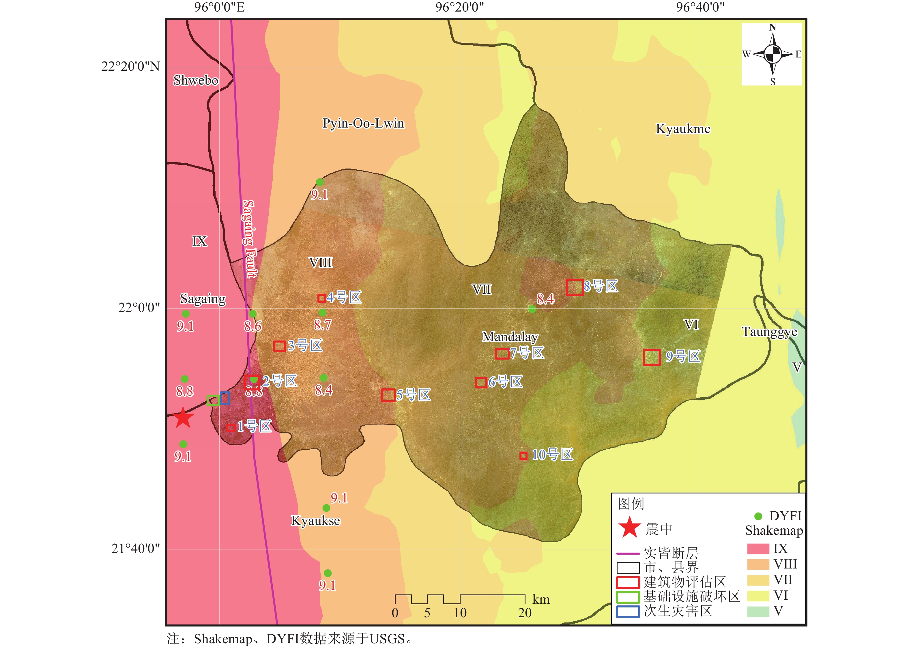
摘要: 2025年3月28日14时20分,缅甸实皆省(21.85°N,95.95°E)发生7.9级强震,震源深度30 km。此次地震引发了大规模建筑物损毁、地表断裂及次生灾害,造成该国及邻国重大人员伤亡和财产损失。本文以曼德勒市为例,详细对比震前和震后遥感影像,通过目视解译,精细判别了建筑物破坏、重大基础设施破坏、次生灾害等,系统评估了灾害损失和地震烈度,浅析了震害原因,讨论了此次地震的经验教训。结果表明:(1)曼德勒市西部地区遥感震害指数为0.67,预估烈度可能达10度,中西部地区遥感震害指数为0.52,预估烈度可能达9度,中部地区遥感震害指数为0.35,预估烈度可能达8度,东部地区遥感震害指数为0.27,预估烈度7~8度;(2)人员伤亡可能会集中在西部地区和中部地区,东部地区可能会有极少数人员伤亡情况;(3)高分遥感影像为此次地震灾情评估提供了高精度、动态化的数据支撑,评估结果与相关报道基本相符。研究结果有助于判断受灾情况,为震后恢复重建提供科学依据。Abstract: At 14:20 on March 28, 2025, a strong magnitude 7.9 earthquake struck the Sagaing Region of Myanmar (21.85°N, 95.95°E) at a focal depth of 30 km. The earthquake caused large-scale building damage, surface ruptures, and secondary disasters, resulting in severe casualties and property losses in Myanmar and neighboring countries. Taking Mandalay as a case study, this paper presents a detailed comparison of remote sensing images acquired before and after the earthquake, and conducts a fine-scale identification of building damage, major infrastructure damage, and secondary disasters through visual interpretation. Based on these analyses, disaster losses and seismic intensity are systematically assessed, and the causes of earthquake damage are briefly examined together with the lessons learned from this event. The results show that: (1) the remote-sensing-based damage index in western Mandalay is 0.67, corresponding to an estimated intensity of up to X; the index in the mid-western part is 0.52, corresponding to an estimated intensity of up to IX; the index in the central part is 0.35, corresponding to an estimated intensity of up to VIII; and the index in the eastern part is 0.27, corresponding to an estimated intensity of VII–VIII. (2) Casualties were likely concentrated in the western and central areas, whereas very few casualties likely occurred in the eastern area. (3) High-resolution remote sensing imagery provided high-precision and dynamic data support for the disaster assessment of this earthquake, and the assessment results are generally consistent with relevant reports. These findings are helpful for accurately judging the disaster situation and provide a scientific basis for post-earthquake recovery and reconstruction.1)
1 2http://www.xinhuanet.com/world/20250403/1d2cb5ddb41042d69ab164c9a8fbe42b/c.html -
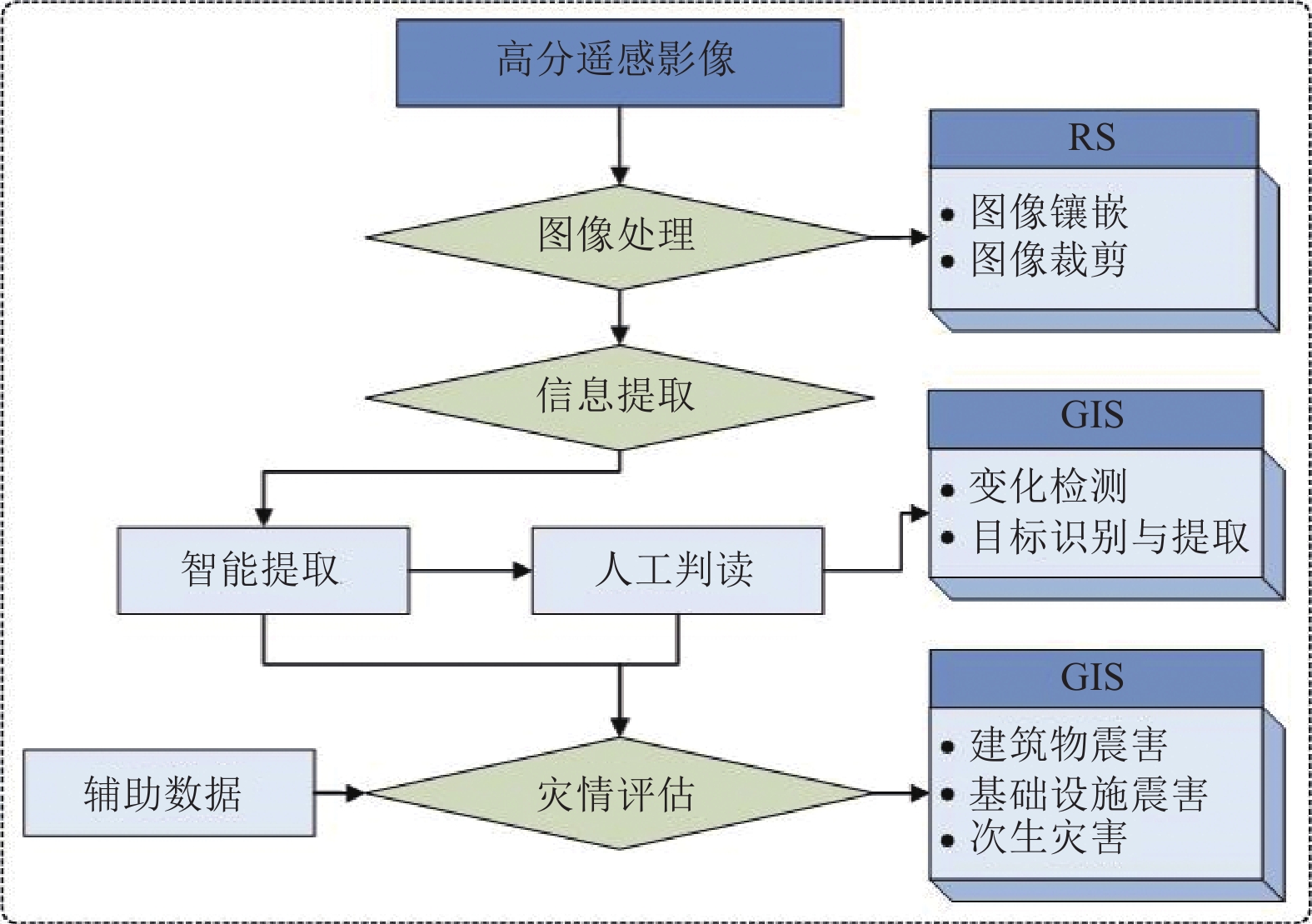
图 3 缅甸地震高分遥感影像灾情评估技术流程
Figure 3. Technical workflow for disaster assessment using Gaofen remote sensing images of the Myanmar earthquake
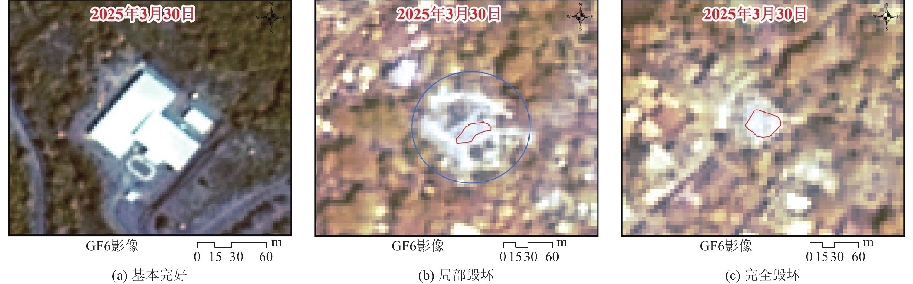
图 4 单体建筑物震后遥感解译
Figure 4. Post-earthquake remote sensing interpretation of individual building

图 6 缅甸地震灾前灾后建筑物破坏遥感影像(灾前:Google 2025-02-24,灾后:GF6 2025-03-30)
Figure 6. Remote sensing images showing building damage before and after the Myanmar earthquake (Pre-earthquake: Google 2025-02-24; Post-earthquake: GF6 2025-03-30)
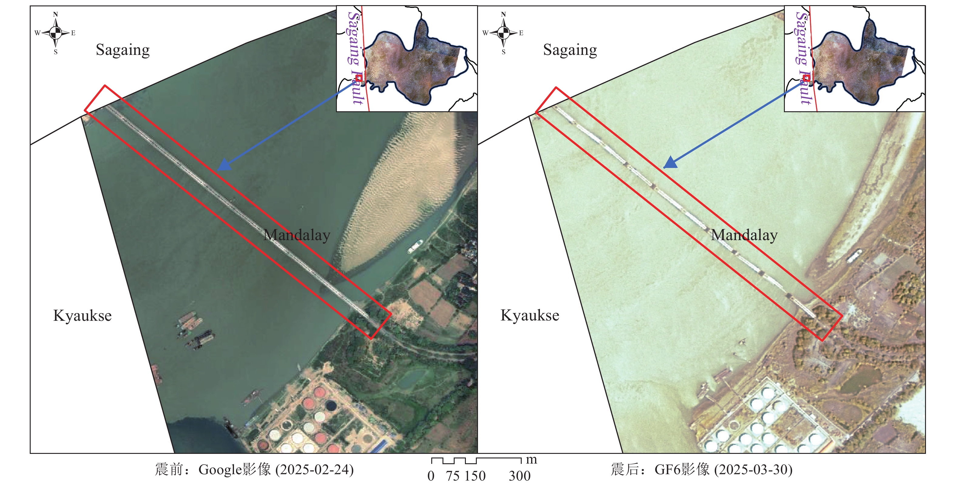
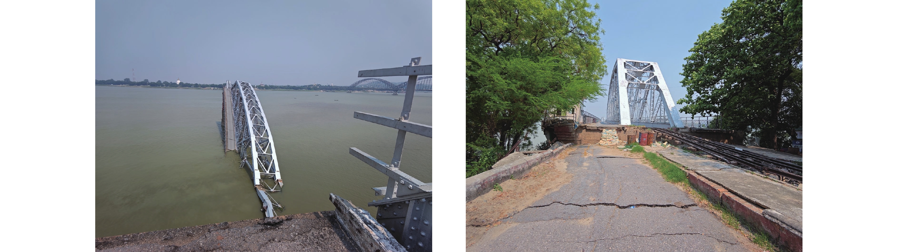
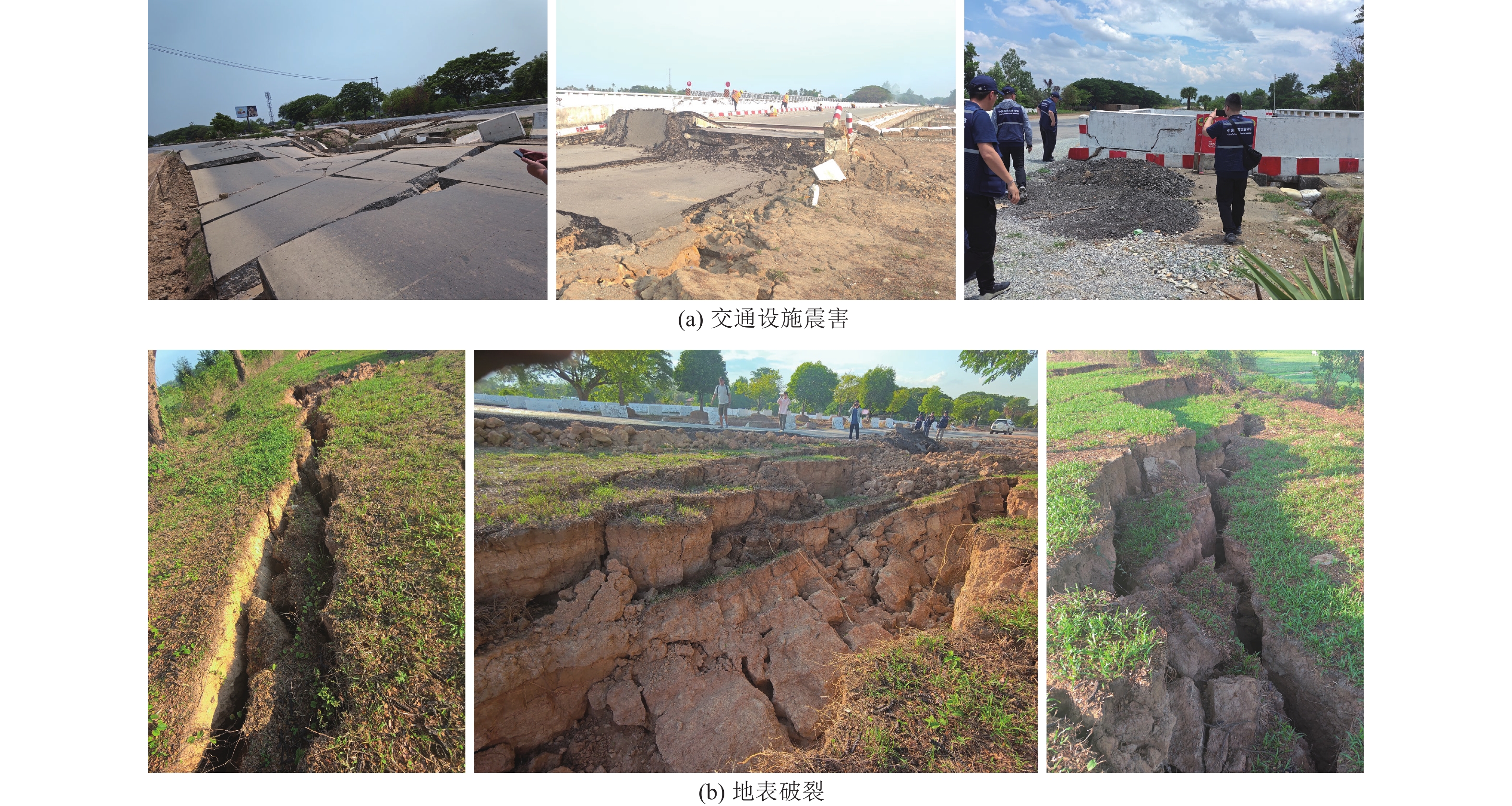
图 8 缅甸地震灾前、灾后基础设施破坏遥感影像
Figure 8. Remote sensing images showing infrastructure damage before and after the Myanmar earthquake

图 10 缅甸地震灾前、灾后次生灾害遥感影像
Figure 10. Remote sensing images showing secondary disasters before and after the Myanmar earthquake
表 1 高分遥感影像
Table 1. High-resolution remote sensing imagery
项目 影像 空间分辨率 拍摄时间 备注 震前 Google 全色:0.5 m
多光谱:2 m2015—2021年 5景镶嵌影像 震后 GF6 全色:2 m
多光谱:8 m2025-03-30 2景  下载: 导出CSV
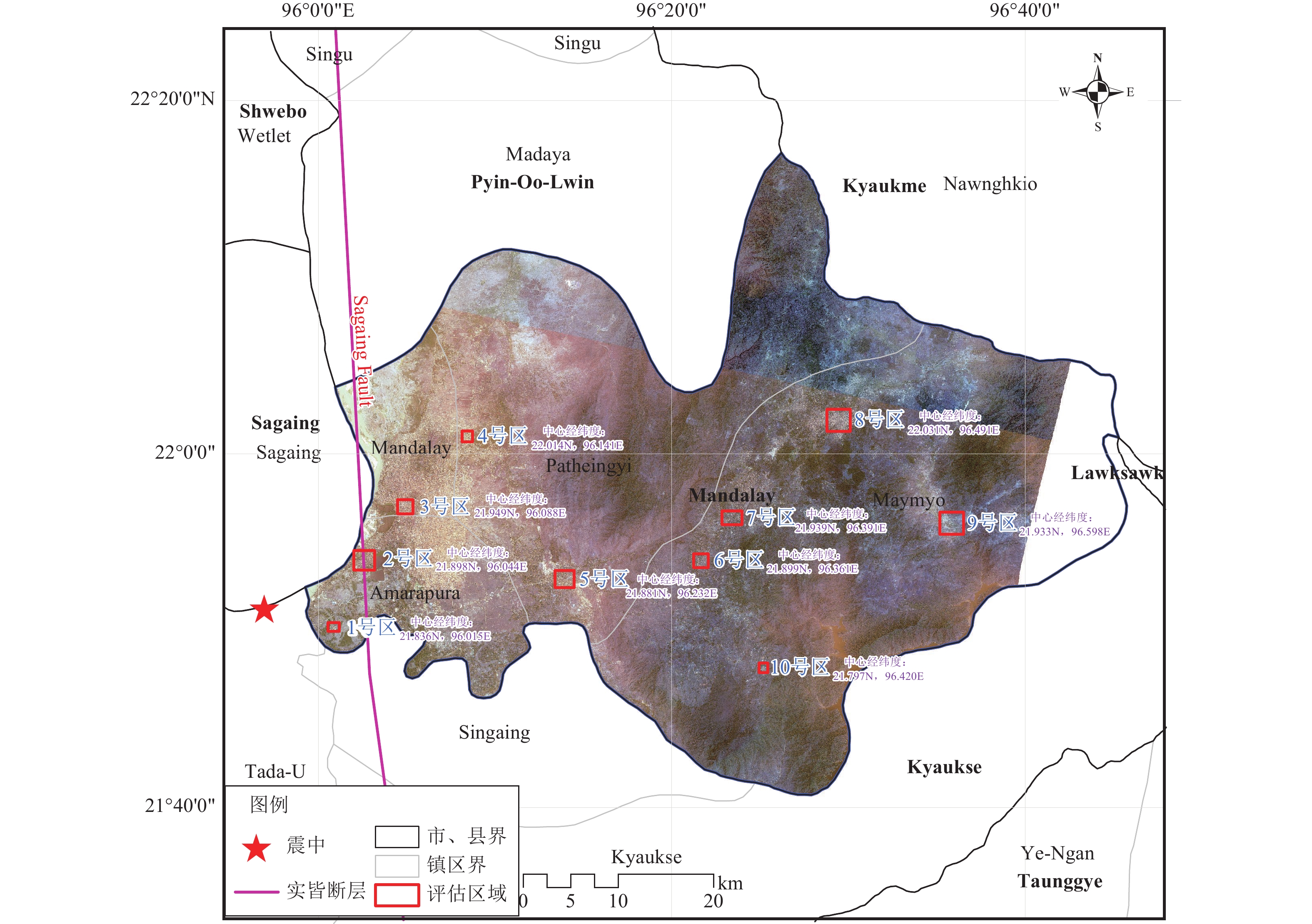
表 2 建筑物遥感解译结果
Table 2. Building remote sensing interpretation results
破坏情况 1号区 2号区 3号区 4号区 5号区 6号区 7号区 8号区 9号区 10号区 基本完好/栋 53 255 386 326 225 135 185 460 60 70 局部破坏/栋 15 76 96 58 38 15 18 36 4 8 倒塌/栋 8 53 46 36 16 6 8 16 2 3
下载: 导出CSV
-
安立强, 张景发, Monteiro R. 等, 2024. 地震灾害损失评估与遥感技术现状和展望. 遥感学报, 28(4): 860−884. doi: 10.11834/jrs.20232093An L. Q., Zhang J. F., Monteiro R., et al., 2024. A review and prospective research of earthquake damage assessment and remote sensing. National Remote Sensing Bulletin, 28(4): 860−884. (in Chinese) doi: 10.11834/jrs.20232093 陈梦, 王晓青, 2019. 全卷积神经网络在建筑物震害遥感提取中的应用研究. 震灾防御技术, 14(4): 810−820.Chen M., Wang X. Q., 2019. The study on extraction of seismic damage of buildings from remote sensing image based on fully convolutional neural network. Technology for Earthquake Disaster Prevention, 14(4): 810−820. (in Chinese) 陈帅, 苗则朗, 吴立新, 2023. 顾及坡体赋存环境的概率地震滑坡危险性制图. 测绘学报, 52(9): 1548−1561.Chen S., Miao Z. L., Wu L. X., 2023. Probabilistic seismic landslide hazard mapping with consideration of slope occurrence environment. Acta Geodaetica et Cartographica Sinica, 52(9): 1548−1561. (in Chinese) 陈文凯, 何少林, 周中红, 2010. 基于多源数据的震害快速评估方法探讨. 西北地震学报, 32(1): 76−81. doi: 10.3969/j.issn.1000-0844.2010.01.014Chen W. K., He S. L., Zhou Z. H., 2010. Study on rapid evaluation method of earthquake damage based on multi-source data. Northwestern Seismological Journal, 32(1): 76−81. (in Chinese) doi: 10.3969/j.issn.1000-0844.2010.01.014 窦爱霞, 王晓青, 丁香等, 2012. 遥感震害快速定量评估方法及其在玉树地震中的应用. 灾害学, 27(3): 75−80. doi: 10.3969/j.issn.1000-811X.2012.03.016Dou A. X., Wang X. Q., Ding X., et al., 2012. Quantitative methods of rapid earthquake damage assessment using remote sensing and its application in Yushu earthquake. Journal of Catastrophology, 27(3): 75−80. (in Chinese) doi: 10.3969/j.issn.1000-811X.2012.03.016 和海霞, 武斌, 李儒等, 2018. 面向自然灾害应急的卫星协同观测策略研究. 航天返回与遥感, 39(6): 91−101.He H. X., Wu B., Li R., et al., 2018. Research on requirements and strategies of satellite cooperative observation for natural disaster emergency response. Spacecraft Recovery & Remote Sensing, 39(6): 91−101. (in Chinese) 贺跃光, 姜风航, 苗则朗等, 2023. 基于深度学习和持续同调的LiDAR林下滑坡提取. 矿冶工程, 43(5): 32−36. doi: 10.3969/j.issn.0253-6099.2023.05.007He Y. G., Jiang F. H., Miao Z. L., et al., 2023. Identification of landslide in forest using LiDAR data based on deep learning and persistent homology. Mining and Metallurgical Engineering, 43(5): 32−36. (in Chinese) doi: 10.3969/j.issn.0253-6099.2023.05.007 李金香, 赵朔, 金花等, 2019. 结合纹理和形态学特征的高分遥感影像建筑物震害信息提取. 地震学报, 41(5): 658−670. doi: 10.11939/jass.20190014Li J. X., Zhao S., Jin H., et al., 2019. A method of combined texture features and morphology for building seismic damage information extraction based on GF remote sensing images. Acta Seismologica Sinica, 41(5): 658−670. (in Chinese) doi: 10.11939/jass.20190014 李强, 张景发, 2016. 不同特征融合的震后损毁建筑物识别研究. 地震研究, 39(3): 486−493. doi: 10.3969/j.issn.1000-0666.2016.03.018Li Q., Zhang J. F., 2016. Research on earthquake damaged building extraction by different features fusion. Journal of Seismological Research, 39(3): 486−493. (in Chinese) doi: 10.3969/j.issn.1000-0666.2016.03.018 李强, 2018. 多模式遥感数据地震应急关键技术研究. 哈尔滨: 中国地震局工程力学研究所.Li Q., 2018. Study on key technology of earthquake emergency using multi-mode remote sensing data. Harbin: Institute of Engineering Mechanics, China Earthquake Administration. (in Chinese) 柳稼航, 杨建峰, 魏成阶等, 2004. 震害信息遥感获取技术历史、现状和趋势. 自然灾害学报, 13(5): 46−52.Liu J. H., Yang J. F., Wei C. J., et al., 2004. Acquisition of earthquake damage information based on remote sensing technology: history, current situation and trend. Journal of Natural Disasters, 13(5): 46−52. (in Chinese) 刘如山, 余世舟, 颜冬启等, 2014. 地震破坏与经济损失快速评估精细化方法研究. 应用基础与工程科学学报, 22(5): 928−940.Liu R. S., Yu S. Z., Yan D. Q., et al., 2014. Refined method for rapid assessment of seismic damage and economic loss. Journal of Basic Science and Engineering, 22(5): 928−940. (in Chinese) 马建, 唐丽华, 吴国栋, 2023. 基于无人机影像的房屋信息提取技术初步研究. 震灾防御技术, 18(2): 293−300. doi: 10.11899/zzfy20230210Ma J., Tang L. H., Wu G. D., 2023. Preliminary research on house information extraction technology based on UAV images. Technology for Earthquake Disaster Prevention, 18(2): 293−300. (in Chinese) doi: 10.11899/zzfy20230210 任丛荣, 李培, 2025.7. 9级缅甸地震对房屋建筑的评估与启示. 华南地震, 45(2): 163−167.Ren C. R. , Li P. , 2025. Assessment and inspiration of buildings in Myanmar M7.9 earthquake. South China Journal of Seismology, 45(2): 163−167. (in Chinese) 王栋梁, 2007. 遥感震害指数与地面调查震害指数关系的定量研究. 北京: 中国地震局地震预测研究所. 王海峰, 周成江, 陈雪峰等, 2024. 无人机高分遥感图像检测震灾中损坏建筑物. 遥感学报, 28(4): 911−925. doi: 10.11834/jrs.20221569Wang H. F., Zhou C. J., Chen X. F., et al., 2024. Detection of earthquake-damaged buildings via UAV high-resolution remote sensing images. National Remote Sensing Bulletin, 28(4): 911−925. (in Chinese) doi: 10.11834/jrs.20221569 王龙, 2007. 基于遥感影像的地震灾害损失评估方法研究与实现. 北京: 中国地震局地震预测研究所.Wang L., 2007. Research and implementation of earthquake disaster loss assessment method based on remote sensing images. Beijing: Institute of Earthquake Forecasting, China Earthquake Administration. (in Chinese) 王晓青, 魏成阶, 苗崇刚等, 2003. 震害遥感快速提取研究−−以2003年2月24日巴楚−伽师6.8级地震为例. 地学前缘, 10(S1): 285−291. doi: 10.3321/j.issn:1005-2321.2003.z1.039Wang X. Q., Wei C. J., Miao C. G., et al., 2003. The extraction of seismic damage from remote sensing images−−a case study of Bachu-Jiashi earthquake with MS6.8 occurred on Feb. 24, 2003. Earth Science Frontiers, 10(S1): 285−291. (in Chinese) doi: 10.3321/j.issn:1005-2321.2003.z1.039 王晓青, 窦爱霞, 孙国清等, 2013. 基于综合震害指数的玉树地震烈度遥感评估研究. 地震, 33(2): 1−10. doi: 10.3969/j.issn.1000-3274.2013.02.001Wang X. Q., Dou A. X., Sun G. Q., et al., 2013. Intensity assessment of the 2010 Yushu MS7.1 earthquake based on synthetic seismic damage index. Earthquake, 33(2): 1−10. (in Chinese) doi: 10.3969/j.issn.1000-3274.2013.02.001 王晓青, 窦爱霞, 王龙等, 2015a. 2013年四川芦山7.0级地震烈度遥感评估. 地球物理学报, 58(1): 163−171. doi: 10.6038/cjg20150114Wang X. Q., Dou A. X., Wang L., et al., 2015a. RS-based assessment of seismic intensity of the 2013 Lushan, Sichuan, China MS7.0 earthquake. Chinese Journal of Geophysics, 58(1): 163−171. (in Chinese) doi: 10.6038/cjg20150114 王晓青, 黄树松, 丁香等, 2015b. 尼泊尔8.1级地震建筑物震害遥感提取与分析. 震灾防御技术, 10(3): 481−490. doi: 10.11899/zzfy20150301Wang X. Q., Huang S. S., Ding X., et al., 2015b. Extraction and analysis of building damage caused by Nepal MS8.1 earthquake from remote sensing images. Technology for Earthquake Disaster Prevention, 10(3): 481−490. (in Chinese) doi: 10.11899/zzfy20150301 魏成阶, 刘亚岚, 王世新等, 2000. 台湾南投“9.21”地震震害卫星遥感监测评估. 见: 遥感科技论坛-全国地方遥感应用协会年会. 北京: 中国遥感应用协会, 124−128. 魏成阶, 刘亚岚, 王世新等, 2008. 四川汶川大地震震害遥感调查与评估. 遥感学报, 12(5): 673−682.Wei C. J., Liu Y. L., Wang S. X., et al., 2008. Investigation and assessment of damage in earthquake Wenchuan Sichuan quake based on remote sensing. Journal of Remote Sensing, 12(5): 673−682. (in Chinese) 肖修来, 翟玮, 郭晓等, 2020. 结合变差纹理特征的极化SAR建筑物震害信息提取. 地震工程学报, 42(2): 568−578. doi: 10.3969/j.issn.1000-0844.2020.02.568Xiao X. L., Zhai W., Guo X., et al., 2020. Extraction of building seismic damage information from polarimetric SAR images based on variogram texture features. China Earthquake Engineering Journal, 42(2): 568−578. (in Chinese) doi: 10.3969/j.issn.1000-0844.2020.02.568 叶阳, 杨健强, 张方浩等, 2026. 2025年缅甸7.9级地震典型建筑震害特征调查及分析. 地震研究, 49(1): 1−16. doi: 10.20015/j.cnki.ISSN1000-0666.2026.0001Ye Y., Yang J. Q., Zhang F. H., et al., 2026. Investigation and analysis of the seismic damage to the typical buildings in the 2025 Myanmar M 7.9 earthquake. Journal of Seismological Research, 49(1): 1−16. (in Chinese) doi: 10.20015/j.cnki.ISSN1000-0666.2026.0001 于浩, 贾晓东, 庞巧等, 2023. 基于无人机影像的辽宁农居建筑物提取技术与应用研究. 震灾防御技术, 18(1): 96−106.Yu H., Jia X. D., Pang Q., et al., 2023. Research on extraction technology and application of rural residential buildings in Liaoning province based on UAV image. Technology for Earthquake Disaster Prevention, 18(1): 96−106. (in Chinese) 张景发, 李强, 张庆云等, 2018. 多源遥感图像的1976年MS7.8唐山大地震等烈度区判定. 遥感学报, 22(S1): 162−173.Zhang J. F., Li Q., Zhang Q. Y., et al., 2018. Intensity zone of the 1976 MS7.8 Tangshan earthquake based on multi-source remote sensing images. Journal of Remote Sensing, 22(S1): 162−173. (in Chinese) 张雪华, 王晓青, 杜晓霞等, 2019. 基于无人机遥感影像及其点云特征的建筑物震害提取. 地震研究, 42(2): 230−235. doi: 10.3969/j.issn.1000-0666.2019.02.011Zhang X. H., Wang X. Q., Du X. X., et al., 2019. Extraction of buildings' seismic damage based on remote sensing images of UAV and its point clouds characteristic. Journal of Seismological Research, 42(2): 230−235. (in Chinese) doi: 10.3969/j.issn.1000-0666.2019.02.011 张莹, 郭红梅, 尹文刚等, 2022. 基于特征提取的SVM图像分类技术的无人机遥感建筑物震害识别应用研究. 灾害学, 37(4): 30−36, 56. doi: 10.3969/j.issn.1000-811X.2022.04.006Zhang Y., Guo H. M., Yin W. G., et al., 2022. Application of SVM image classification technology based on feature extraction in seismic damage identification of buildings by UAV remote sensing. Journal of Catastrophology, 37(4): 30−36,56. (in Chinese) doi: 10.3969/j.issn.1000-811X.2022.04.006 赵妍, 张景发, 姚磊华, 2016. 基于面向对象的高分辨率遥感建筑物震害信息提取与评估. 地震学报, 38(6): 942−951. doi: 10.11939/jass.2016.06.014Zhao Y., Zhang J. F., Yao L. H., 2016. Seismic damage information extraction and evaluation of buildings with high resolution remote sensing based on object-oriented method. Acta Seismologica Sinica, 38(6): 942−951. (in Chinese) doi: 10.11939/jass.2016.06.014 邹俊杰, 邵志刚, 何宏林等, 2025. 2025年1月7日西藏定日MS6.8地震地表破裂解译与建筑物震害损毁统计. 地震地质, 47(1): 16−35. doi: 10.3969/j.issn.0253-4967.2025.01.002Zou J. J., Shao Z. G., He H. L., et al., 2025. Surface rupture interpretation and building damage assessment of Xizang Dingri MS6.8 earthquake on January 7, 2025. Seismology and Geology, 47(1): 16−35. (in Chinese) doi: 10.3969/j.issn.0253-4967.2025.01.002 Asif M., Abrar M., Ullah F., et al., 2025. A novel hybrid deep learning approach for super-resolution and objects detection in remote sensing. Scientific Reports, 15(1): 17221. doi: 10.1038/s41598-025-01476-3 Diao H. Q., Ren Y. F., Wen R. Z., et al., 2025. Supershear rupture process of the 2025 Myanmar earthquake as derived from joint inversion of near-field and teleseismic waveforms. Earthquake Engineering and Engineering Vibration, 24(4): 917−925. doi: 10.1007/s11803-025-2347-z Wang H. W., Wen R. Z., Peng Z., et al., 2025. Integrated source-site effects on seismic intensity in the 2025 Myanmar earthquake from the three-component ground motion simulations by stochastic finite-fault method. Earthquake Engineering and Engineering Vibration, 24(4): 901−915. doi: 10.1007/s11803-025-2344-2 -


 点击查看大图
计量
- 文章访问数: 200
- HTML全文浏览量: 84
- PDF下载量: 167
- 被引次数: 0
