


Assessment on Earthquake Damage and Economic Recovery Based on Nighttime Light Data
-
摘要: 2023年2月6日,土耳其连续发生2次强震,哈塔伊省人员伤亡惨重,基础设施大量损毁。为快速全面评估地震损害与重建情况,利用震前月度和震后每日夜间灯光(NTL)数据变化比率识别哈塔伊省地震损害度。通过月度NTL数据计算平均灯光强度(ALI),借助数据平滑与季节分解技术去除ALI时间序列中的随机噪声和季节波动。基于地震前后的回归模型,搭建震后经济恢复评估框架。结果表明,地震损害的整体精度达到77.28%,可用于地震损害的评估;构建的回归模型拟合度较高,适用于震后区域经济恢复的评估。在县级层面,灾后埃尔津、库姆卢和安塔基亚县经济已经恢复,多尔蒂约尔和萨曼达县的经济恢复困难,其余7个县的经济预计2026年3月前恢复。整体上,哈塔伊省经济增长缓慢,全面恢复时间尚无法确定。Abstract: On February 6, 2023, two strong earthquakes struck Turkey, causing significant casualties and extensive damage to infrastructure in Hatay Province. To quickly and comprehensively assess earthquake damage and reconstruction, this study utilized the change ratio in pre-earthquake monthly and post-earthquake daily nighttime light (NTL) data to identify earthquake damage in Hatay Province. The average lighting index (ALI) was calculated using monthly NTL data, with random noise and seasonal fluctuations removed from the ALI time series through data smoothing and seasonal decomposition techniques. A post-earthquake economic recovery assessment framework was constructed based on pre- and post-earthquake regression models. The results show that the overall accuracy of earthquake damage assessment is 77.28%, making it suitable for evaluating earthquake damage. The constructed regression model has a high fit, making it useful for assessing post-earthquake regional economic recovery. At the county level, the economies of Erzin, Kumlu, and Antakya have recovered post-disaster, while Dortyol and Samandag are facing difficulties in economic recovery. The economies of the remaining seven counties are expected to recover by March 2026. Overall, the economic growth in Hatay Province is slow, and the timeline for complete recovery remains uncertain.
-
Key words:
- Nighttime light /
- Turkey earthquake /
- Damage degree /
- Post-earthquake economic recovery
1)1 https://www.arcgis.com/home/item.html?id=86941dbff14e450bbe3f89897373c59a#overview . -
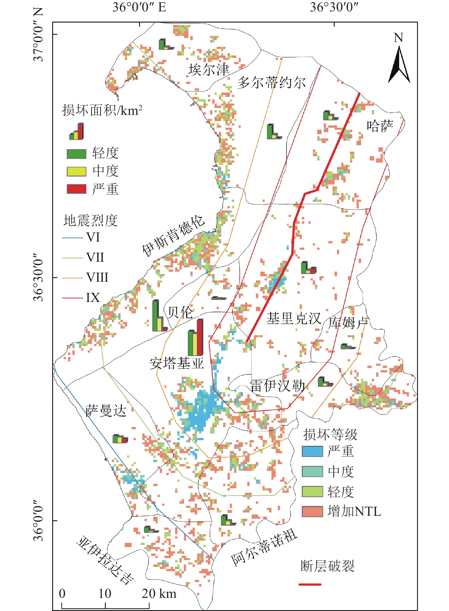
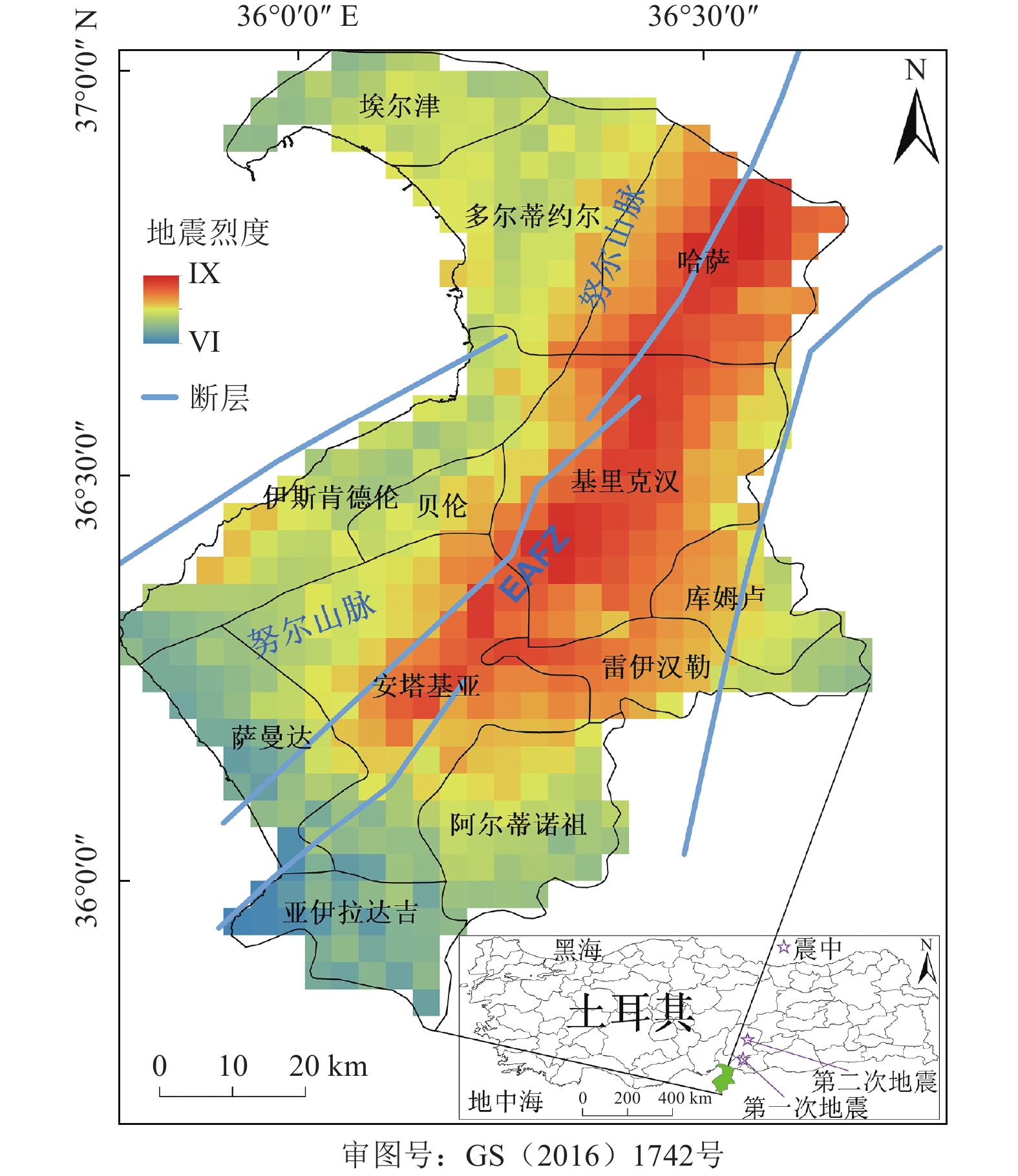
图 3 NPP-VIIRS NTL数据绘制的震后损坏程度和损坏面积图
Figure 3. Maps of damaged level and damaged area after the earthquake using NPP-VIIRS NTL data
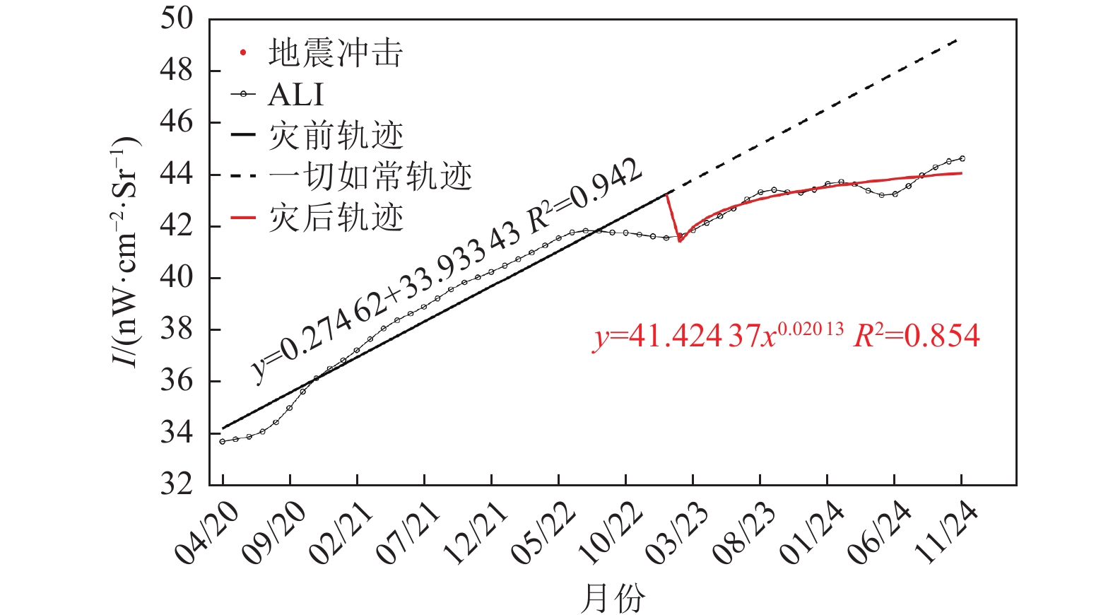
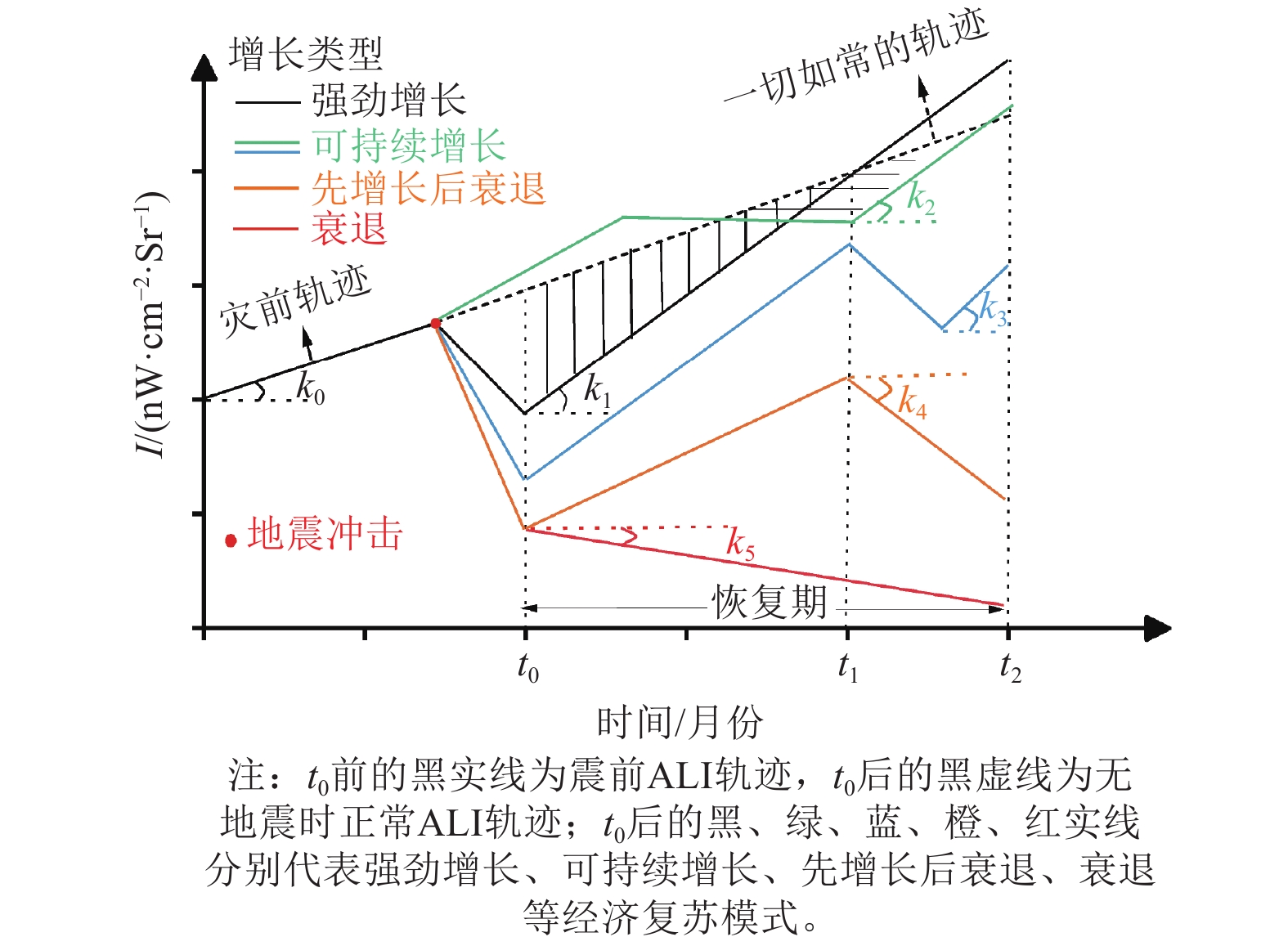
图 4 哈塔伊省震后经济恢复框架
Figure 4. Post-earthquake economic recovery framework in Hatay Province
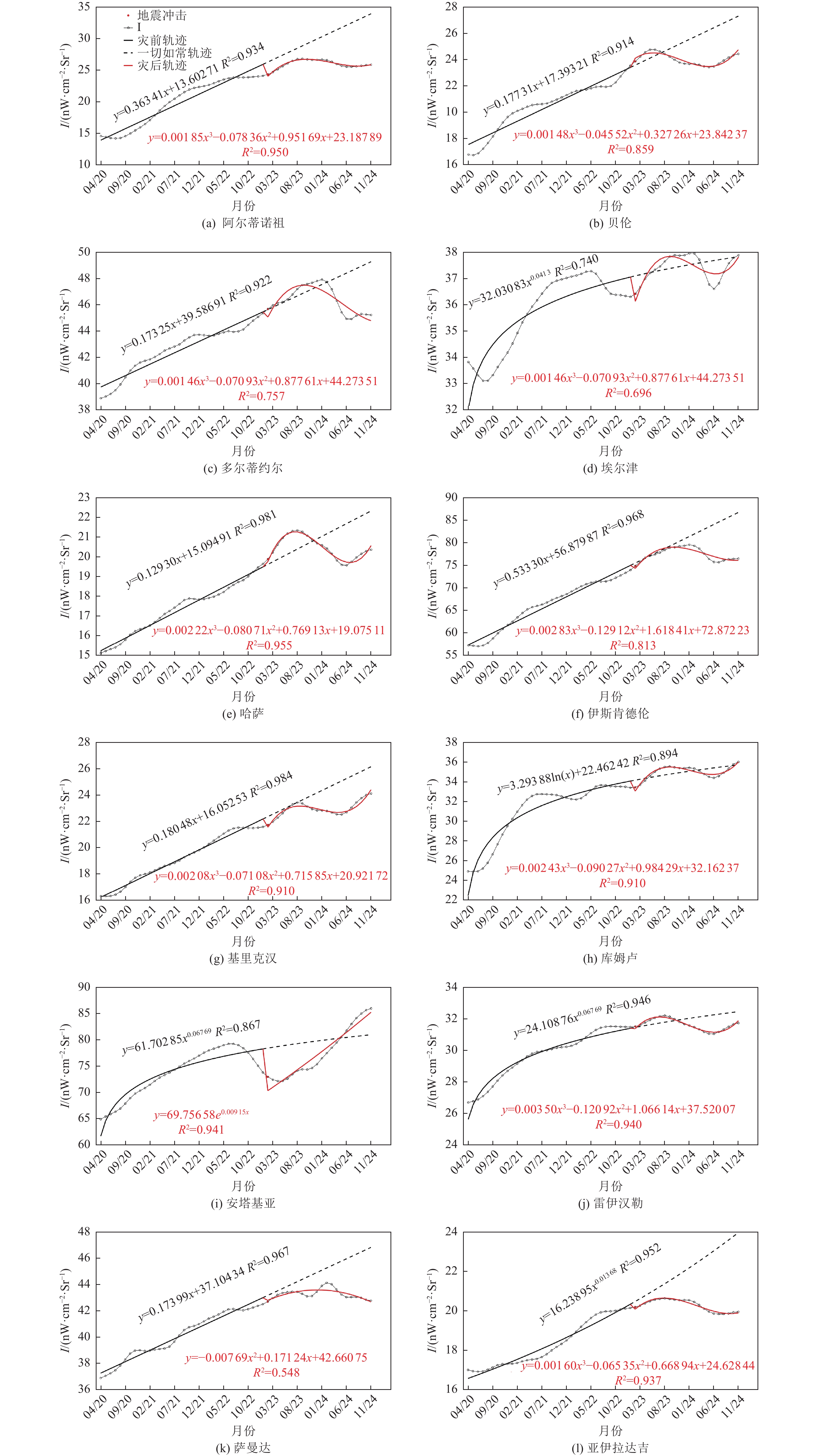
图 5 哈塔伊省县级震后经济恢复框架
Figure 5. Post-earthquake economic recovery framework for the counties of Hatay Province
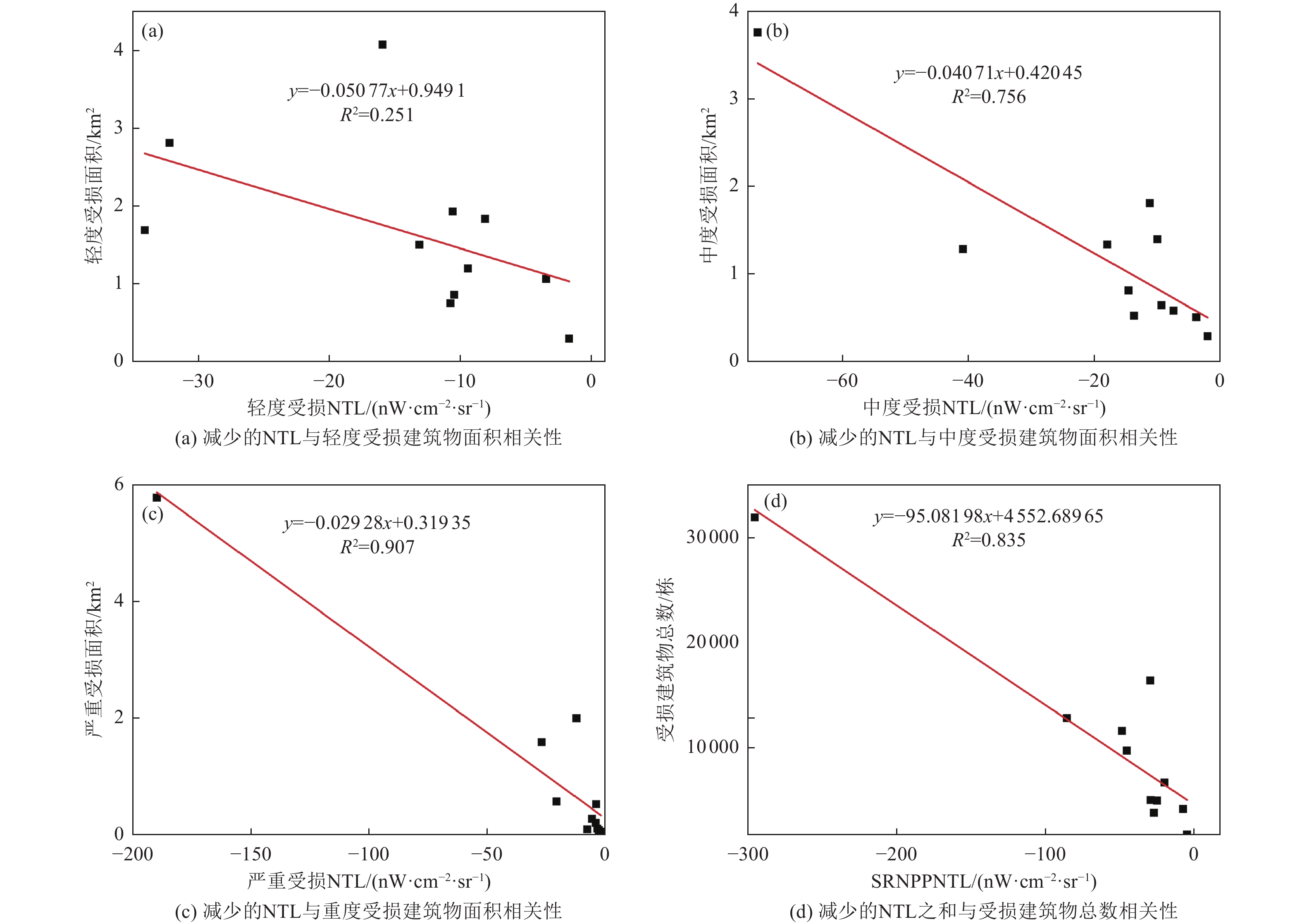
图 6 减少的NPP-VIIRS NTL与3种受损建筑物面积以及受损建筑物总数之间的相关性的相关性
Figure 6. Correlation between the reduced SRNPP-VIIRS NTL and the areas of three types of damaged buildings, as well as the total number of damaged buildings
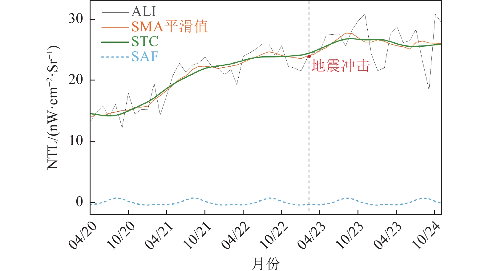
图 7 阿尔蒂诺祖2020年4月~11月的ALI时间序列数据、SMA平滑值、STC和SAF
Figure 7. Time series data for ALI, SMA-smoothed values, STC, and SAF in the Altinozu, covering the period from April 2020 to November 2024
表 1 基于NTL数据的地震损坏精度评估
Table 1. Accuracy assessment of earthquake damage based on NTL data
参考数据源 类别 CE/% OE/% OA/% KC EOS 损害 26.66 18.43 77.28 0.55 无损害 18.35 26.56  下载: 导出CSV
表 2 地震前后回归模型的统计检验
Table 2. Statistical test of regression models before and after the earthquake
县名 震前 县名 震后 R2 F p R2 F p 哈塔伊 0.94 522.86 0.00 哈塔伊 0.85 117.34 0.00 阿尔蒂诺祖 0.93 455.05 0.00 阿尔蒂诺祖 0.95 114.41 0.00 贝伦 0.91 341.40 0.00 贝伦 0.86 36.56 0.00 多尔蒂约尔 0.92 375.68 0.00 多尔蒂约尔 0.76 18.73 0.00 埃尔津 0.74 91.19 0.00 埃尔津 0.70 13.72 0.00 哈萨 0.98 1633.23 0.00 哈萨 0.96 128.72 0.00 伊斯肯德伦 0.97 957.90 0.00 伊斯肯德伦 0.81 26.17 0.00 基里克汉 0.98 1923.83 0.00 基里克汉 0.91 60.62 0.00 库姆卢 0.89 271.01 0.00 库姆卢 0.91 60.38 0.00 安塔基亚 0.87 209.03 0.00 安塔基亚 0.94 318.92 0.00 雷伊汉勒 0.95 559.58 0.00 雷伊汉勒 0.94 94.06 0.00 萨曼达 0.97 930.72 0.00 萨曼达 0.55 11.50 0.00 亚伊拉达吉 0.95 631.81 0.00 亚伊拉达吉 0.94 89.17 0.00
下载: 导出CSV
-
中国地震局, 2023. 2月6日18时24分土耳其发生7.8级地震. (2023-02-06)[2025-05-10]. https://www.cea.gov.cn/cea/dzpd/zqsd/5711192/index.html. Alahmadi M., Mansour S., Dasgupta N., et al., 2021. Using daily nighttime lights to monitor spatiotemporal patterns of human lifestyle under COVID-19: the case of Saudi Arabia. Remote Sensing, 13(22): 4633. Chen L., Yu L. S., Yin J. B., et al., 2023a. Impact of population density on spatial differences in the economic growth of urban agglomerations: the case of Guanzhong plain urban agglomeration, China. Sustainability, 15(19): 14601. Chen X. L., Li X., Liu Z. M., 2023b. Evaluation of earthquake disaster recovery patterns and influencing factors: a case study of the 2008 Wenchuan earthquake. All Earth, 35(1): 132−148. doi: 10.1080/27669645.2023.2207942 Choi S., An J., 2024. Multisensor feature selection for maritime target estimation. Electronics, 13(22): 4497. Duerler R., Cao C. X., Xie B., et al., 2023. Cross reference of GDP decrease with nighttime light data via remote sensing diagnosis. Sustainability, 15(8): 6900. Fan X. W., Nie G. Z., Deng Y., et al., 2019. Rapid detection of earthquake damage areas using VIIRS nearly constant contrast night-time light data. International Journal of Remote Sensing, 40(5-6): 2386−2409. Gao S. J., Chen Y. H., Liang L., et al., 2020. Post-earthquake night-time light piecewise (PNLP) pattern based on NPP/VIIRS night-time light data: a case study of the 2015 Nepal earthquake. Remote Sensing, 12(12): 2009. doi: 10.3390/rs12122009 GFDRR, 2023. Global Rapid post-disaster Damage Estimation (GRADE) report. (2023-02-20)[2025-05-10]. https://documents1.worldbank.org/curated/en/099022723021250141/pdf/P1788430aeb62f08009b2302bd4074030fb.pdf. Gu J. C., Xie Z. T., Zhang J. D., et al., 2024. Advances in rapid damage identification methods for post-disaster regional buildings based on remote sensing images: a survey. Buildings, 14(4): 898. Herianto H., Sofroniou A., Fitrah M., et al., 2024. Quantifying the relationship between self-efficacy and mathematical creativity: a meta-analysis. Education Sciences, 14(11): 1251. Jia M. H., Li X., Gong Y., et al., 2023. Estimating natural disaster loss using improved daily night-time light data. International Journal of Applied Earth Observation and Geoinformation, 120: 103359. Levin N., 2023. Using night lights from space to assess areas impacted by the 2023 Turkey earthquake. Remote Sensing, 15(8): 2120. Li F., Liu X. Y., Liao S. S., et al., 2021. The modified normalized urban area composite index: a satellite-derived high-resolution index for extracting urban areas. Remote Sensing, 13(12): 2350. Li F., Liu J., Zhang M. D., et al., 2023. Assessment of economic recovery in Hebei Province, China, under the COVID-19 pandemic using nighttime light data. Remote Sensing, 15(1): 22. Li F., Liao S. B., Liu W. L., 2024. Assessment of post-pandemic economic recovery in Beijing, China, using night-time light data. Remote Sensing Letters, 15(6): 603−613. Li L. L., Liang P., Jiang S., et al., 2022. Multi-scale dynamic analysis of the Russian–Ukrainian conflict from the perspective of night-time lights. Applied Sciences, 12(24): 12998. Li X., Liu Z. M., Chen X. L., et al., 2019. Assessment of the impact of the 2010 Haiti earthquake on human activity based on DMSP/OLS time series nighttime light data. Journal of Applied Remote Sensing, 13(4): 044515. Liu C. L., Tang Q. D., Xu Y. P., et al., 2022. High-spatial-resolution nighttime light dataset acquisition based on volunteered passenger aircraft remote sensing. IEEE Transactions on Geoscience and Remote Sensing, 60: 1001817. Liu H. L., Luo N. X., Hu C. C., 2020. Detection of county economic development using LJ1-01 nighttime light imagery: a comparison with NPP-VIIRS data. Sensors, 20(22): 6633. Liu Z. M., Zhang J. F., Li X., et al., 2021. Long-Term resilience curve analysis of Wenchuan earthquake-affected counties using DMSP-OLS nighttime light images. IEEE Journal of Selected Topics in Applied Earth Observations and Remote Sensing, 14: 10854−10874. Qiang Y., Huang Q. X., Xu J. W., 2020. Observing community resilience from space: using nighttime lights to model economic disturbance and recovery pattern in natural disaster. Sustainable Cities and Society, 57: 102115. Sarkar S., 2021. Rapid assessment of cyclone damage using NPP-VIIRS DNB and ancillary data. Natural Hazards, 106(1): 579−593. UNDP, 2024. UNDP launches new recovery efforts as Türkiye marks first anniversary of devastating earthquakes. (2024-02-06)[2025-05-10]. https://www.undp.org/turkiye/press-releases/undp-launches-new-recovery-efforts-turkiye-marks-first-anniversary-devastating-earthquakes. Wang J. F., Zhang J. F., Gong L. X., et al., 2018. Indirect seismic economic loss assessment and recovery evaluation using nighttime light images – application for Wenchuan earthquake. Natural Hazards and Earth System Sciences, 18(12): 3253−3266. Wang L. Y., Li Z. T., Han J., et al., 2024. A cost-effective earthquake disaster assessment model for power systems based on nighttime light information. Applied Sciences, 14(6): 2325. Wikipedia, 2025. Hatay Province. (2025-03-30)[2025-05-10]. https://en.wikipedia.org/wiki/Hatay_Province. Xiao B. M., Hu S. S., Ai W. H., et al., 2024a. Night-time light loss during the 2022 Kyiv offensive revealed through VIIRS DNB. European Journal of Remote Sensing, 57(1): 2362387. Xiao Z. Y., Pan Y. Y., Jiang L. L., et al., 2024b. Remote sensing nighttime lights reveal the post-earthquake losses and reconstruction situations in Turkey–Syria earthquake areas. IEEE Geoscience and Remote Sensing Letters, 21: 3002405. Yuan Y., Wang C. X., Liu S. Y., et al., 2023. The changes in nighttime lights caused by the Turkey–Syria earthquake using NOAA-20 VIIRS day/night band data. Remote Sensing, 15(13): 3438. Zhang D. R., Huang H. L., Roy N., et al., 2023a. Black marble nighttime light data for disaster damage assessment. Remote Sensing, 15(17): 4257. Zhang H. L., Yu Q. Z., Liu Y. J., et al., 2023b. The spatio-temporal patterns of regional development in Shandong Province of China from 2012 to 2021 based on nighttime light remote sensing. Sensors, 23(21): 8728. Zheng Q. M., Seto K. C., Zhou Y. Y., et al., 2023. Nighttime light remote sensing for urban applications: progress, challenges, and prospects. ISPRS Journal of Photogrammetry and Remote Sensing, 202: 125−141. Zheng X. R., Li L. Y., 2024. Trading cloud computing stocks using SMA. Information, 15(8): 506. Zheng Y. M., Shao G. F., Tang L. N., et al., 2019. Rapid assessment of a typhoon disaster based on NPP-VIIRS DNB daily data: the case of an urban agglomeration along western Taiwan Straits, China. Remote Sensing, 11(14): 1709. Zheng Z. H., Wu Z. F., Chen Y. B., et al., 2022. A simple method for near-real-time monthly nighttime light image production. IEEE Geoscience and Remote Sensing Letters, 19: 8008405. -

 点击查看大图
计量
- 文章访问数: 74
- HTML全文浏览量: 28
- PDF下载量: 162
- 被引次数: 0
