
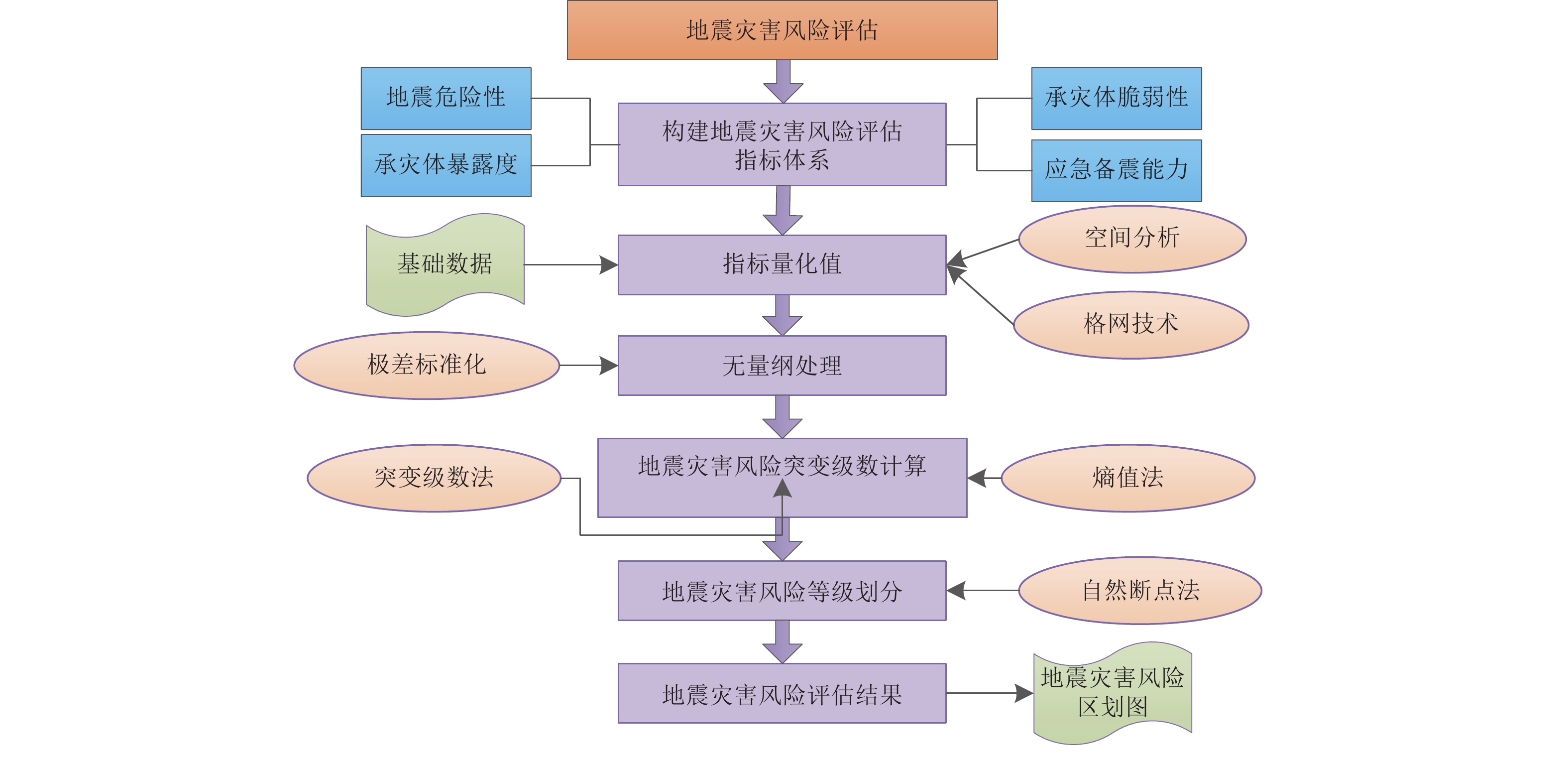
Earthquake Disaster Risk Assessment Based on Entropy-Catastrophe Progression Method: A Case Study of Rong County
-
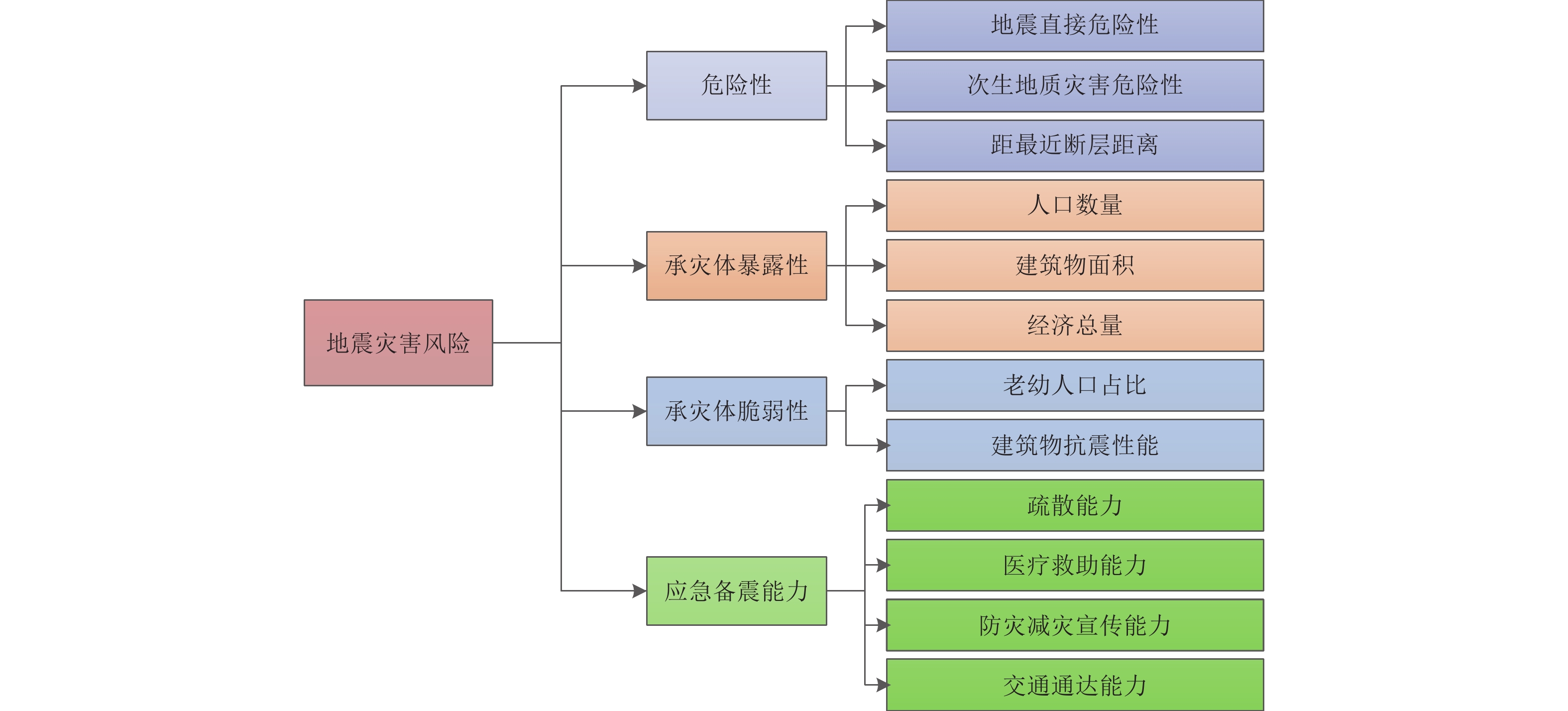
摘要: 针对传统地震灾害风险评估研究中指标赋权主观性较大的问题,提出一种基于熵值-突变级数法的地震灾害风险评估方法。首先从地震危险性、承灾体暴露度、承灾体脆弱性和应急备震能力4个维度出发,构建了反映地震灾害风险自然属性和社会属性的指标体系。然后,利用熵权法计算指标权重,进行重要性排序,再结合控制变量数目,选择合适的突变类型,建立地震灾害风险评估模型。最后,应用该评价模型,对荣县地震灾害风险等级进行评估。结果表明:长山镇、旭阳镇北部及保华镇南部处于地震灾害高风险水平,旭阳镇、来牟镇和高山镇地震灾害风险水平较高,河口镇和正紫镇地震灾害风险水平为较低风险,地震灾害风险中等及较低的区域零星的分布在各乡镇。Abstract: Aiming at the subjective problem of index weighting in traditional earthquake disaster risk assessment, this paper proposes an earthquake disaster risk assessment method based on entropy-catastrophe progression method. Firstly, an indicator system reflecting the natural and social attributes of earthquake disaster risk was constructed from four dimensions: seismic hazard, exposure of disaster-bearing body, vulnerability of disaster-bearing body, and emergency preparedness capacity. Then, the entropy weight method was used to calculate the index weights and rank their importance. Combined with the number of control variables, the appropriate catastrophe type was selected to establish the earthquake disaster risk assessment model. Finally, this evaluation method was applied to assess the earthquake disaster risk level of Rong County. The results show that Changshan Town, the northern part of Xuyang Town and the southern part of Baohua Town are at a high risk level of earthquake disasters. Xuyang Town, Laimou Town and Gaoshan Town have a relatively high risk level of earthquake disasters. The risk level of earthquake disasters in Hekou Town and Zhengzi Town is relatively low. Areas with medium and low earthquake disaster risk are scattered in various towns.
-
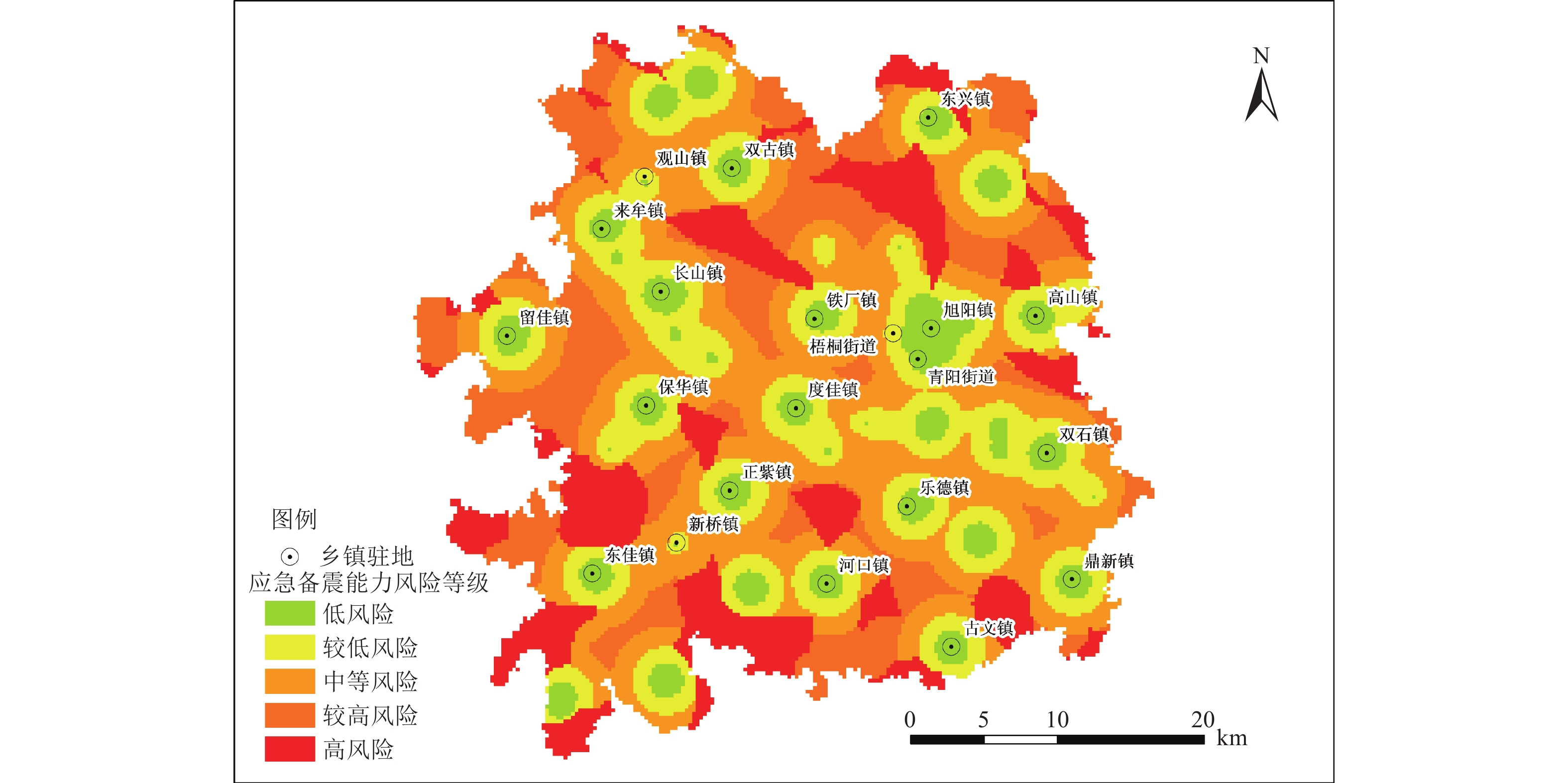
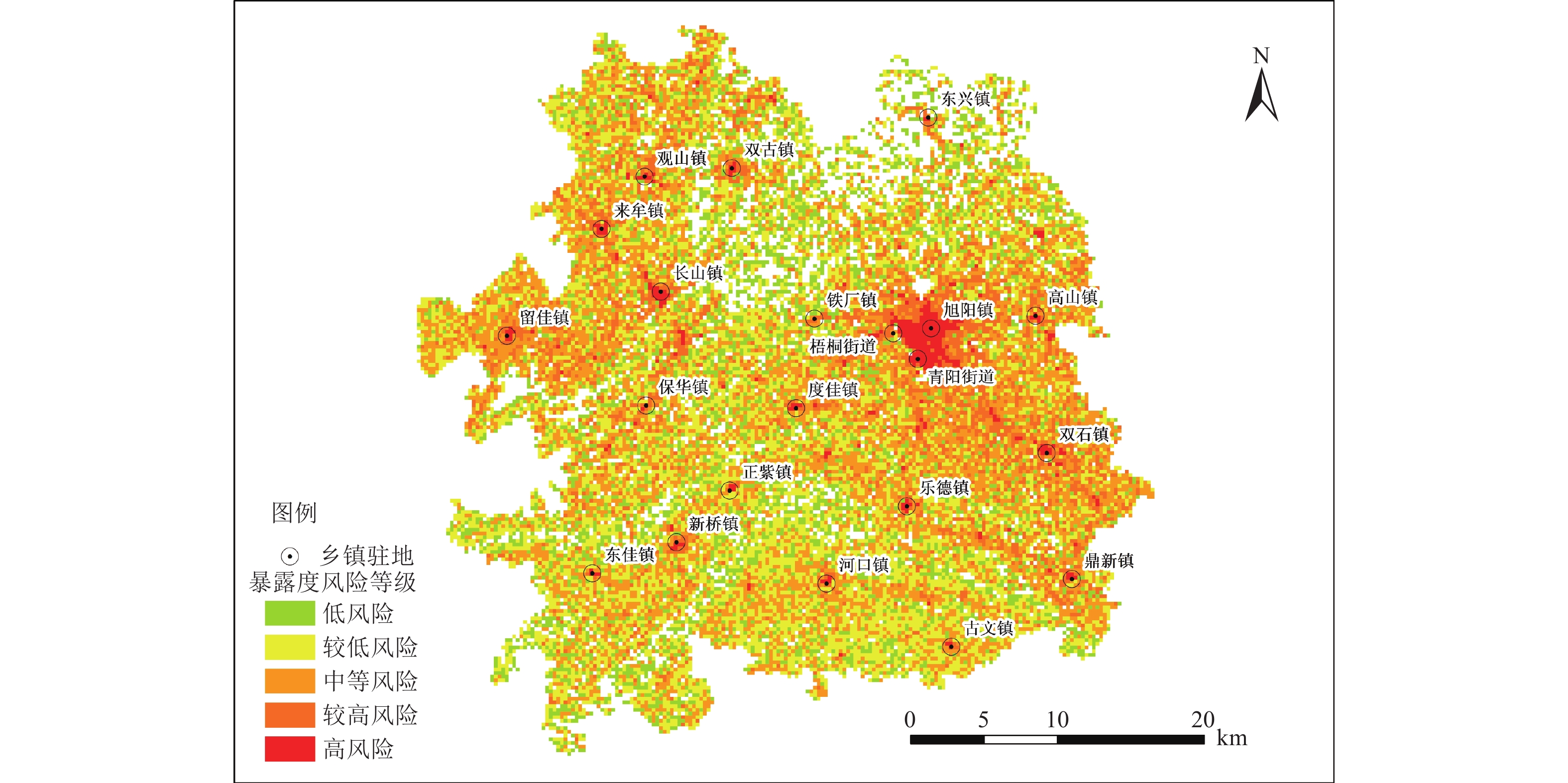
图 6 荣县应急备震能力分布图
Figure 6. Earthquake emergency preparedness distribution map of Rong county
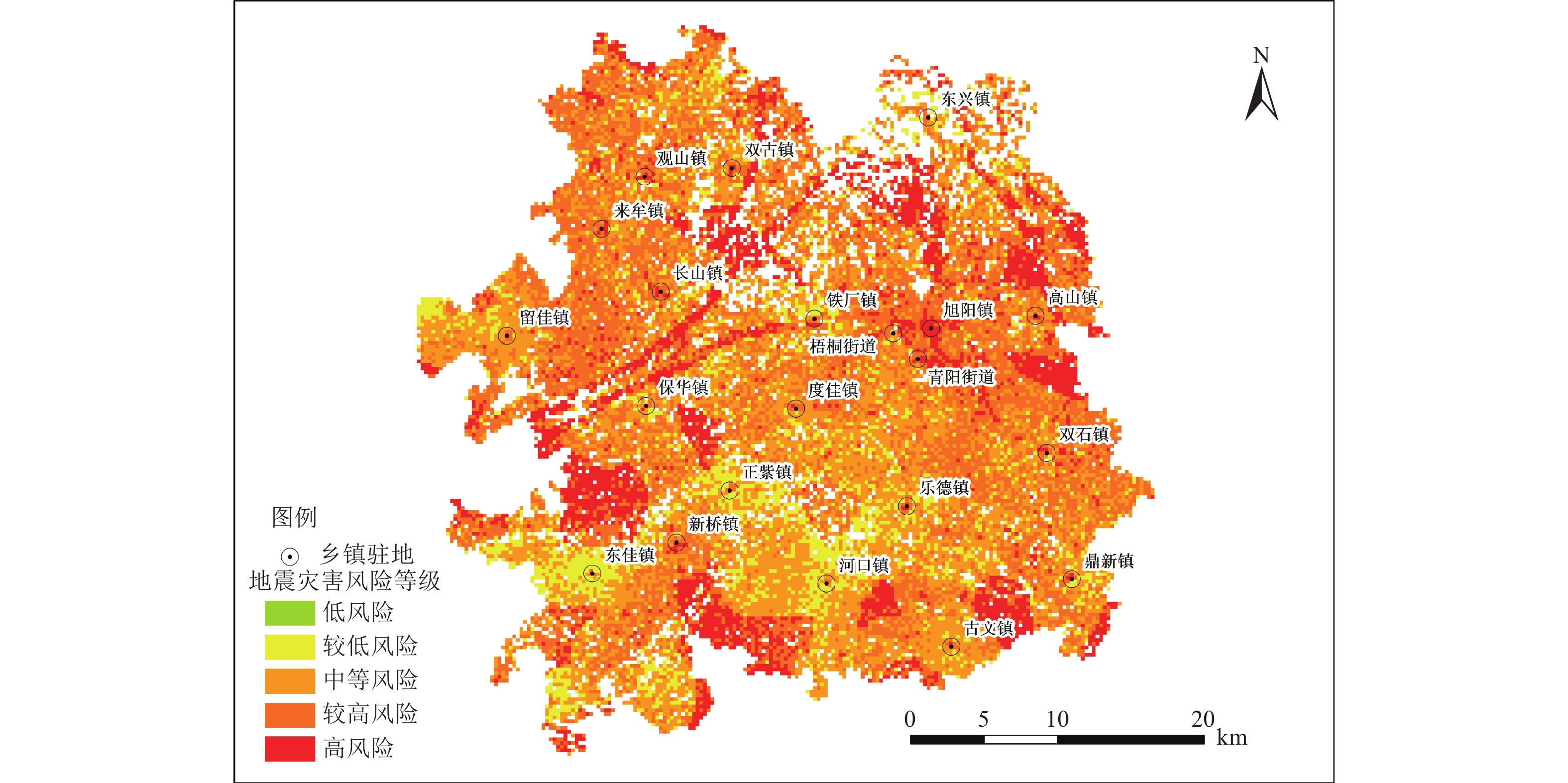
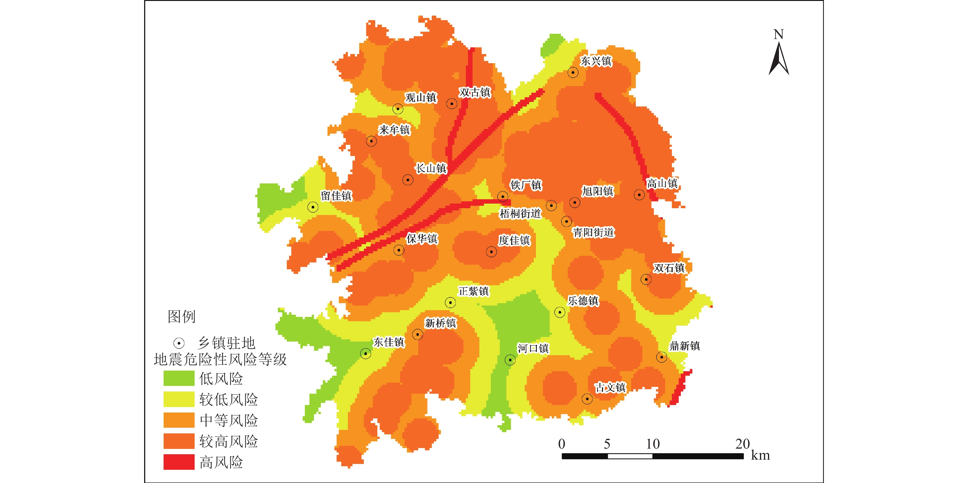
图 7 荣县地震灾害风险等级分布图
Figure 7. Distribution map of earthquake disaster risk levels in Rong county
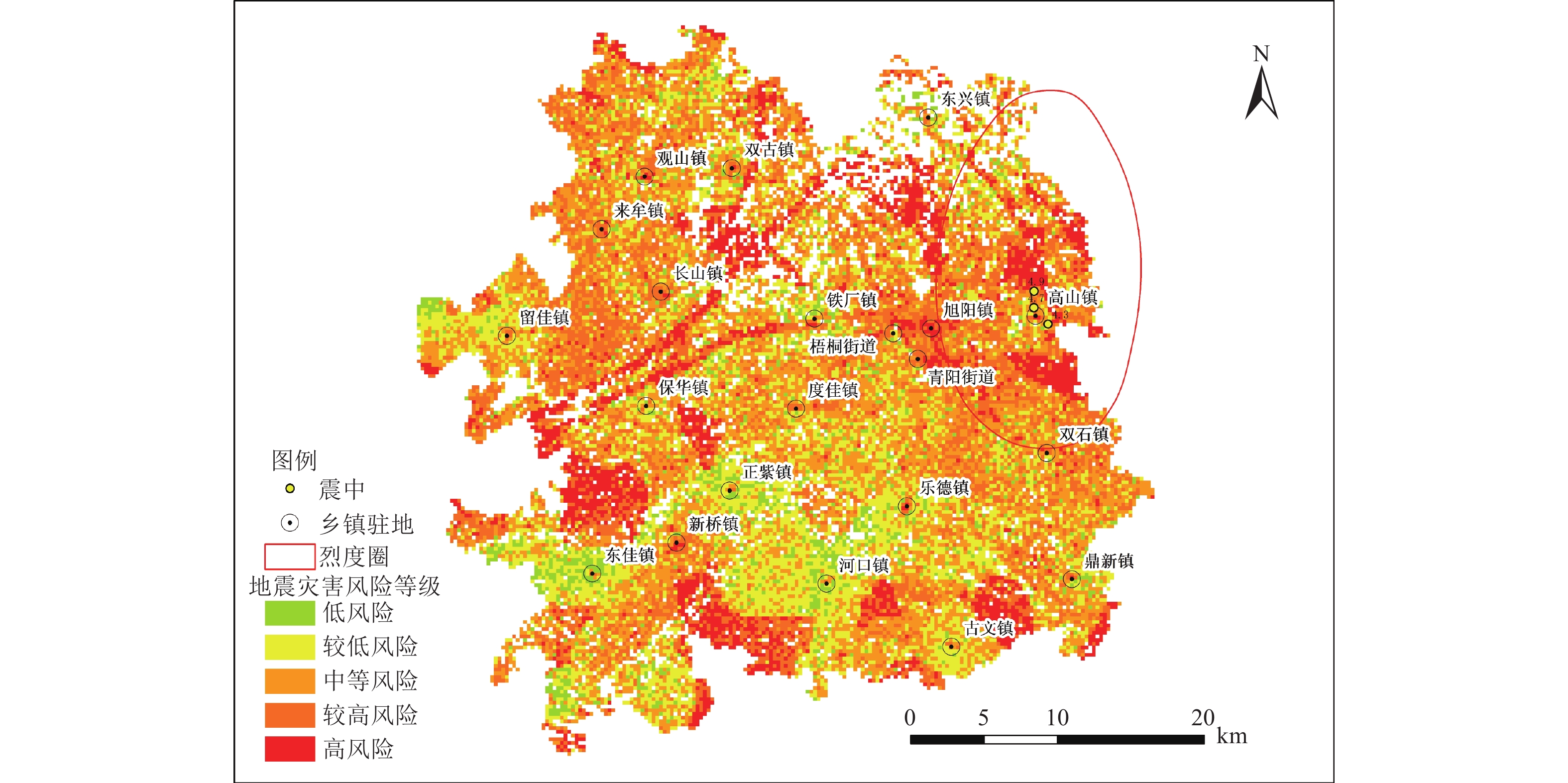
图 8 四川荣县4.7、4.3和4.9级地震烈度图
Figure 8. Seismic intensity map of the MS 4.7, MS 4.3, and MS 4.9 earthquakes in Rong county, Sichuan province
表 1 常用突变模型及相应的归一化公式
Table 1. Common mutation models and their normalization formulas
突变类型 控制变量数 势函数 分歧方程 归一化公式 折叠型 1 $ V\left({x}\right)={x}^{3}+ax $ $ a=-3{x}^{2} $ $ {x}_{a}={a}^{{1}/{2}} $ 尖点型 2 $ V\left({x}\right)={x}^{4}+a{x}^{2}+bx $ $ a=-6{x}^{2},b=8{x}^{3} $ $ {x}_{a}={a}^{{1}/{2}},{x}_{b}={b}^{{1}/{3}} $ 燕尾型 3 $ V\left(\textit{x}\right)=\dfrac{1}{5}{x}^{5}+\dfrac{1}{3}a{x}^{3}+\dfrac{1}{2}b{x}^{2}+c{x} $ $ a=-6{x}^{2},b=8{x}^{3},\mathrm{c}=-3{x}^{4} $ $ {x}_{a}={a}^{{1}/{2}},{x}_{b}={b}^{{1}/{3}},{x}_{c}={c}^{{1}/{4}} $ 蝴蝶型 4 $ V\left(\textit{x}\right)=\dfrac{1}{6}{x}^{6}+\dfrac{1}{4}a{x}^{4}+\dfrac{1}{3}b{x}^{3}+\dfrac{1}{2}c{{x}}^{2}+dx $ $ \begin{aligned}&a=-10{x}^{2},b=20{x}^{3},\mathrm{c}=-15{x}^{4},\\&d=4{x}^{5}\end{aligned} $ $ \begin{aligned}&{x}_{a}={a}^{{1}/{2}},{x}_{b}={b}^{{1}/{3}},{x}_{c}={c}^{{1}/{4}},\\&{x}_{d}={d}^{{1}/{5}}\end{aligned} $ 注:x为系统的状态变量,表示系统的行为状态,4种突变模型皆只有一个状态变量;a、b、c、d表示该状态变量的控制变量,其重要性排序为从左向右。  下载: 导出CSV
-
付泽钰, 翟国方, 2020. 基于多源数据的厦门市地震灾害风险评估. 地震研究, 43(3): 441−448. doi: 10.3969/j.issn.1000-0666.2020.03.003Fu Z. Y., Zhai G. F., 2020. Urban risk assessment of earthquake disaster in Xiamen based on multi-source data model. Journal of Seismological Research, 43(3): 441−448. (in Chinese) doi: 10.3969/j.issn.1000-0666.2020.03.003 郭红梅, 赵真, 张莹等, 2021. 一种适用于山地地区的地震灾害风险评估方法−−以四川省宝兴县为例. 灾害学, 36(3): 147−152. doi: 10.3969/j.issn.1000-811X.2021.03.025Guo H. M., Zhao Z., Zhang Y., et al., 2021. Study on quantitative assessment and classification method of earthquake disaster risk: a case study of Baoxing County. Journal of Catastrophology, 36(3): 147−152. (in Chinese) doi: 10.3969/j.issn.1000-811X.2021.03.025 和仕芳, 赵正贤, 张方浩等, 2023. 基于公里格网的云南昭通地震灾害风险评估. 华北地震科学, 41(4): 16−26.He S. F., Zhao Z. X., Zhang F. H., et al., 2023. Earthquake risk assessment in Zhaotong, Yunnan province based on the 1 km grid cell. North China Earthquake Sciences, 41(4): 16−26. (in Chinese) 黄杏元, 徐寿成, 1998. GIS动态缓冲带分析模型及其应用. 中国图象图形学报, 3(10): 871−873. doi: 10.3969/j.issn.1006-8961.1998.10.014Huang X. Y., Xu S. C., 1998. GIS-based dynamic buffer analysis model and its applications. Journal of Image and Graphics, 3(10): 871−873. (in Chinese) doi: 10.3969/j.issn.1006-8961.1998.10.014 李昌珑, 李宗超, 吕红山等, 2019. 基于三维图像模式识别的西藏东南部地震灾害损失风险评估. 地球物理学报, 62(1): 393−410. doi: 10.6038/cjg2019M0360Li C. L., Li Z. C., Lü H. S., et al., 2019. Seismic disaster loss risk assessment for southeastern Tibet based on 3D image pattern recognition. Chinese Journal of Geophysics, 62(1): 393−410. (in Chinese) doi: 10.6038/cjg2019M0360 李姜, 张合, 刘志辉, 2021. 张家口地区精细化地震灾害风险评估. 震灾防御技术, 16(1): 134−145.Li J., Zhang H., Liu Z. H., 2021. Refined risk assessment of earthquake disaster in Zhangjiakou area. Technology for Earthquake Disaster Prevention, 16(1): 134−145. (in Chinese) 刘军, 宋立军, 聂高众等, 2020. 地震灾害风险评估及减灾策略研究−−以贵州罗甸县为例. 震灾防御技术, 15(3): 484−495.Liu J., Song L. J., Nie G. Z., et al., 2020. Study on earthquake disaster risk assessment and countermeasures: a casa study on Luodian County in Guizhou. Technology for Earthquake Disaster Prevention, 15(3): 484−495. (in Chinese) 唐丽华, 苗崇刚, 宋立军等, 2013. 年度地震危险区地震灾害应急风险评估指标体系构建初探. 灾害学, 28(2): 153−155. doi: 10.3969/j.issn.1000-811X.2013.02.030Tang L. H., Miao C. G., Song L. J., et al., 2013. Index system construction for emergency response risk evaluation on earthquake disasters in annual earthquake risk region. Journal of Catastrophology, 28(2): 153−155. (in Chinese) doi: 10.3969/j.issn.1000-811X.2013.02.030 闻熠, 肖涛, 谈晟荟等, 2022. 基于熵值-突变级数法上海市生态安全评价与对策研究. 生态科学, 41(3): 124−132.Wen Y., Xiao T., Tan S. H., et al., 2022. Study on ecological security evaluation and countermeasure of Shanghai based on entropy and catastrophe progression method. Ecological Science, 41(3): 124−132. (in Chinese) 肖凯灵, 2011. 城市地震灾害风险的损失评价研究. 西安: 西安石油大学.Xiao K. L., 2011. Study of loss assessment of urban earthquake disaster risk. Xi’an: Xi’an Shiyou University. (in Chinese) 徐选华, 张威威, 2016. 基于改进突变级数法的地震灾害社会脆弱性风险评价研究−−基于四川地震灾害案例. 灾害学, 31(3): 125−132. doi: 10.3969/j.issn.1000-811X.2016.03.021Xu X. H., Zhang W. W., 2016. Risk assessment on earthquake disaster social vulnerability based on improved catastrophe progression method−−a case study on Sichuan earthquake disaster. Journal of Catastrophology, 31(3): 125−132. (in Chinese) doi: 10.3969/j.issn.1000-811X.2016.03.021 张方浩, 杜浩国, 邓树荣等, 2022. 以乡镇为单元评估云南省建水县地震灾害风险. 地震研究, 45(1): 109−117. doi: 10.20015/j.cnki.ISSN1000-0666.2022.0012Zhang F. H., Du H. G., Deng S. R., et al., 2022. Assessment of earthquake-hazard risk of Jianshui County, Yunnan province based on township units. Journal of Seismological Research, 45(1): 109−117. (in Chinese) doi: 10.20015/j.cnki.ISSN1000-0666.2022.0012 赵思健, 黄崇福, 郭树军, 2012. 情景驱动的区域自然灾害风险分析. 自然灾害学报, 21(1): 9−17.Zhao S. J., Huang C. F., Guo S. J., 2012. Scenario-driven risk analysis of regional natural disasters. Journal of Natural Disasters, 21(1): 9−17. (in Chinese) 郑秋红, 贾婧, 高惠瑛等, 2019. 基于空间分析技术的海岛地震灾害风险分析研究. 世界地震工程, 35(3): 168−176.Zheng Q. H., Jia J., Gao H. Y., et al., 2019. Research on the seismic disaster risk analysis of islands based on spatial analysis technology. World Earthquake Engineering, 35(3): 168−176. (in Chinese) Earle P. S. , Wald D. J. , Lastowka L. A. , et al. , 2004. Prompt assessment of global earthquakes for response (PAGER): an automated system to estimate impact following significant earthquakes worldwide. In: AGU Fall Meeting Abstracts. San Francisco: AGU. Greiving S., 2006. Integrated risk assessment of multi-hazards: a new methodology. Special Paper - Geological Survey of Finland, 42(42): 75−82. doi: 10.1007/s11069-015-1713-y Mileti D, 1999. Disasters by design: a reassessment of natural hazards in the United States. Washington: Joseph Henry Press, 125−127. -

 点击查看大图
计量
- 文章访问数: 139
- HTML全文浏览量: 63
- PDF下载量: 148
- 被引次数: 0
