
Study on Detailed Geometric Characteristics of the Shuangtangjian-Laoyugou Segment of the Zijiangguan Fault Based on LiDAR Data
-
摘要: 本研究利用机载LiDAR技术详细解析了紫荆关断裂双塘涧-老峪沟段的平面几何特征。通过高分辨率地形数据揭示了断裂的地表迹线和平面展布特征,分析了紫荆关断裂与南口山前断裂的几何连接关系。研究显示,紫荆关断裂沿线主要发育山地、河谷及洪积扇地貌,其中山区表现为断层崖和断层三角面;河谷内普遍发育T0、T1阶地,而T2阶地较少。断裂双塘涧-老峪沟段由多条分支断裂组成,形成右阶斜列形式,这些分支断裂具有明显的线性特征,主要沿山间谷地分布。马套村以南的两条断裂交会部位解译数据显示,紫荆关断裂与南口山前断裂在地表的连接特征呈现复杂性与不连续性,紫荆关断裂表现为较弱的活动性,主要以正断层为主,而南口山前断裂为晚更新世活动断裂,具有显著的倾滑特征。两者的活动性及几何形态差异可能受构造应力场的影响,导致局部断裂重叠、错动以及相对位移,从而形成不完全连接的现象。这些发现为理解华北地区拉张构造背景下的动力学特征与运动学机制提供了新的视角,并对该地区的地震风险评估及地质研究具有重要意义。Abstract: This study employs airborne LiDAR technology to comprehensively analyze the geometric features of Zijinguan fault from Shuangtangjian to Laoyugou. High-resolution topographic data were used to reveal the surface trace and planar distribution of the fault. The geometric relationship between the Zijinguan fault and the Nankou Piedmont fault was also examined. The results indicate that mountainous areas, river valleys, and alluvial fan landforms are mainly developed along the fault zone, with fault scarps and triangular facets commonly observed in the mountainous regions. River valleys generally preserve T0 and T1 terraces, whereas T2 terraces are relatively rare. The northern segment of the fault consists of multiple branch faults, forming a right-stepping en echelon structure. These branch faults display clear linear features and are mainly distributed along mountain valleys. Interpretation of the intersection between the two faults south of Matao shows that the surface connection between the Zijinguan fault and the Nankou Piedmont fault is complex and discontinuous. The Zijinguan fault exhibits weak activity and is mainly characterized as a normal fault, whereas the Nankou Piedmont fault is a late-Pleistocene active fault with significant dip-slip characteristics. The differences in activity and geometric form between the two faults may be controlled by the tectonic stress field, resulting in local overlap, misalignment, and relative displacement, and thus forming an incomplete connection. These findings provide a new perspective for understanding the kinematic mechanisms and dynamic characteristics of faults under the extensional tectonic setting of North China, and are of great significance for regional seismic hazard assessment and geological research.
-
Key words:
- LiDAR /
- Zijingguan fault /
- Fault trace distribution /
- Geometric characteristics
1)1 2中国地震局地质研究所,2023. 河北怀来抽水蓄能电站工程场地地震安全性评价报告.2)2 3 中国地震局地质研究所,2023. 河北怀来抽水蓄能电站工程场地地震安全性评价报告. -

图 1 紫荆关断裂及其周缘活动构造图
Figure 1. Active tectonic map of the Zijingguan fault and its surrounding areas
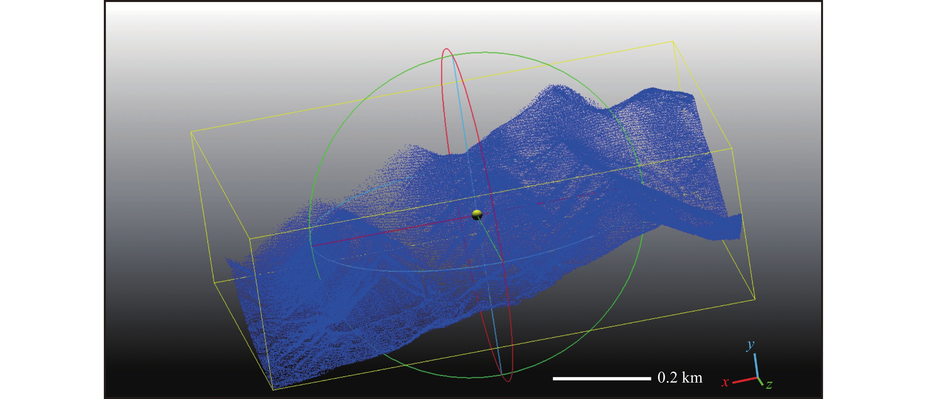
图 2 Cloud Compare软件中点云数据示意图
Figure 2. A schematic diagram of point cloud data in the Cloud Compare software

图 3 紫荆关断裂双塘涧-老峪沟段平面几何展布
Figure 3. Geometric distribution of Shuangtangjian-Laoyugou Segment of the Zijingguan fault
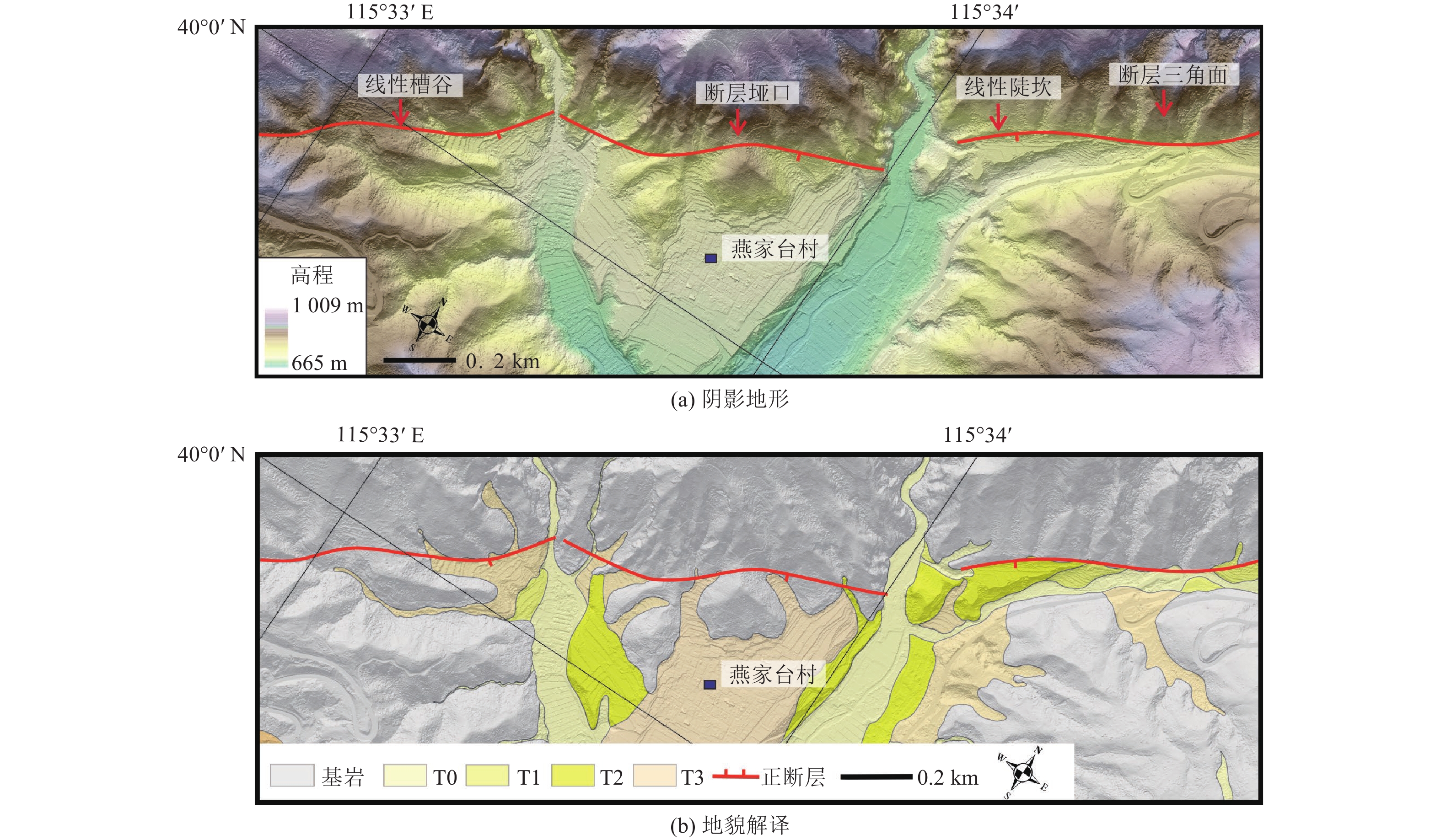
图 4 燕家台阴影地形及地貌解译图
Figure 4. Hillshade of Yanjiatai and its geomorphological interpretation

图 6 马套村断层展布及地貌解译
Figure 6. Fault trace and geomorphological interpretation near in Matao village
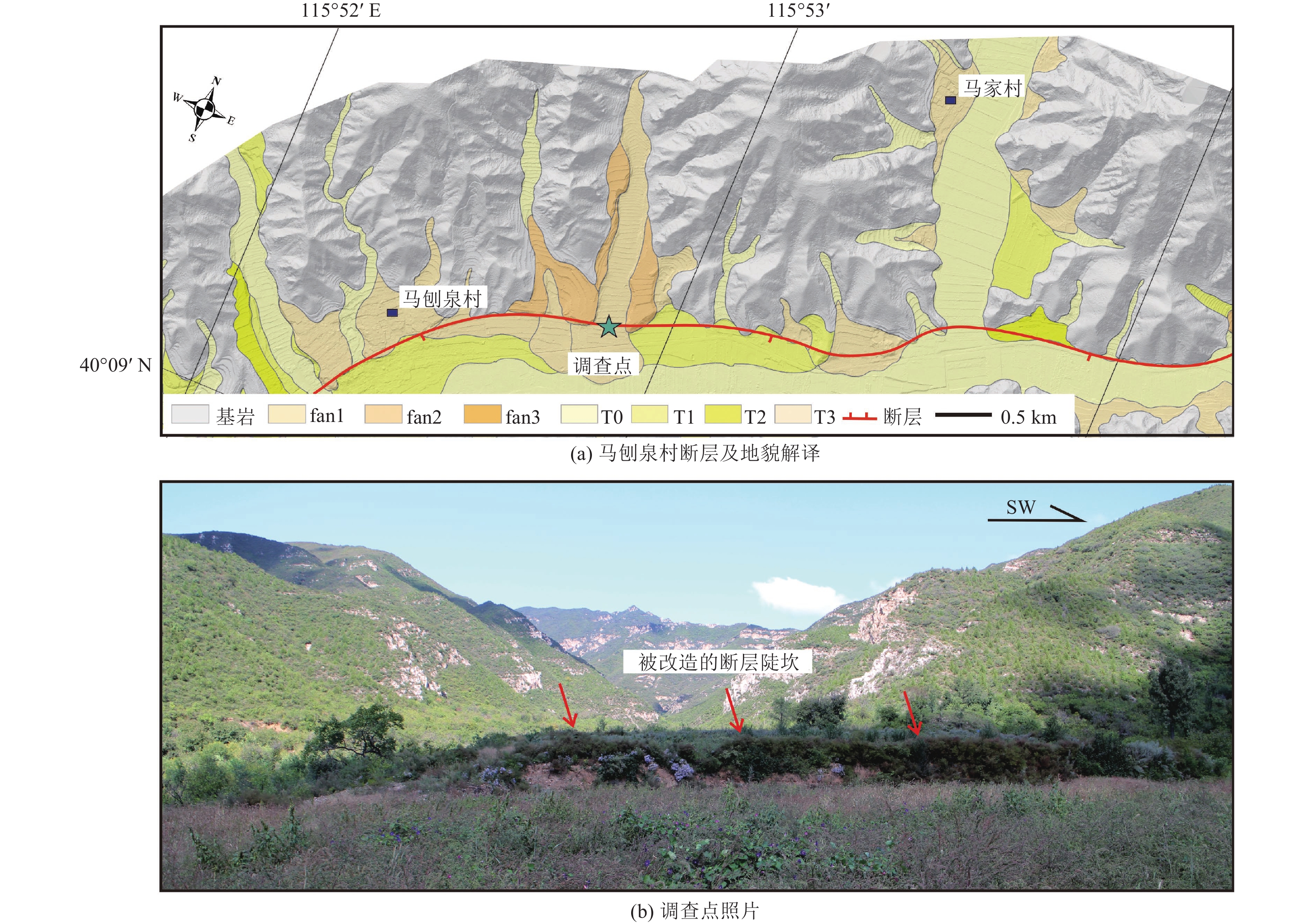
图 7 马刨泉村断层解译及野外照片
Figure 7. Interpretation of fault and field photos at Mapaoquan village
表 1 无人机参数及LiDAR 测量信息
Table 1. UAV parameters and LiDAR measurement data
设备型号 DV-LiDAR500 激光扫描角/(°) 360 测量精度 2 cm(>50 m);0.5 cm(≤50 m) 相对航高H/m 130 航线间隔/m 78 激光扫描重叠度/% 70 地面分辨率/cm 2.6 时速/(km·h−1) 36  下载: 导出CSV
-
陈桂华, 2002. 紫荆关断裂带构造活动特征−−以太行山北段为例. 北京: 中国地质大学(北京).Chen G. H., 2002. Evolution and structural characteristics of Zijingguan fault zone: An example from northern part of Taihang Mountains. Beijing: China University of Geosciences. (Beijing). (in Chinese) 陈涛, 2014. 机载激光雷达技术在构造地貌定量化研究中的应用. 北京: 中国地震局地质研究所.Chen T., 2014. Application of airborne LiDAR (light detection and ranging) for quantitative tectonic geomorphology. Beijing: Institute of Geology, China Earthquake Administration. (in Chinese) 刘静, 陈涛, 张培震等, 2013. 机载激光雷达扫描揭示海原断裂带微地貌的精细结构. 科学通报, 58(1): 41−45.Liu J., Chen T., Zhang P. Z., et al., 2013. Illuminating the active Haiyuan fault, China by airborne light detection and ranging. Chinese Science Bulletin, 58(1): 41−45. (in Chinese) 罗照华, 邓晋福, 赵国春等, 1997. 太行山造山带岩浆活动特征及其造山过程反演. 地球科学−−中国地质大学学报, 22(3): 279−284.Luo Z. H., Deng J. F., Zhao G. C., et al., 1997. Characteristics of magmatic activity and orogenic process inversion in the Taihangshan Orogenic Belt. Earth Science−Journal of China University of Geosciences, 22(3): 279−284. (in Chinese) 齐立华, 刘媛, 2015. 北京昌平南口山前断裂特征及构造解析. 河北北方学院学报(自然科学版), 31(5): 27−30.Qi L. H., Liu Y., 2015. Characteristics and structural analysis of the Nankou frontal fault in Changping, Beijing. Journal of Hebei North University (Natural Science Edition), 31(5): 27−30. (in Chinese) 唐清, 郑文俊, 石霖等, 2020. 基于高精度LiDAR数据的断裂活动习性精细定量−−以香山-天景山断裂景泰小红山段为例. 地震地质, 42(2): 366−381.Tang Q., Zheng W. J., Shi L., et al., 2020. Quantitative study of fault activity based on high-precision airborne LiDAR data: a case of Xiaohongshan fault in Xiangshan-Tianjingshan fault zone. Seismology and Geology, 42(2): 366−381. (in Chinese) 王克鲁, 胡碧茹, 严富华等, 1998. 北京斋堂盆地黄土结构构造与形成环境. 北京地质, 10(1): 1−10.Wang K. L., Hu B. R., Yan F. H., et al., 1998. Texture and structure and palaeoenvironment of loess in Zhaitang basin of Beijing. Beijing Geology, 10(1): 1−10. (in Chinese) 王林, 田勤俭, 2017. 利用夷平面的变形进行断陷地块构造反演−−以京西北蔚广盆地南缘断裂带为例. 地质科学, 52(3): 801−817. doi: 10.12017/dzkx.2017.051Wang L., Tian Q. J., 2017. Tectonic evolution of the faulted block indicated by the deformation of the planation surface: example from the research of the Yuguang Basin south marginal fault in the northwest Beijing basin-ridge tectonic zone. Chinese Journal of Geology (Scientia Geologica Sinica), 52(3): 801−817. (in Chinese) doi: 10.12017/dzkx.2017.051 魏占玉, 何宏林, 高伟等, 2014. 基于LiDAR数据开展活动断层填图的实验研究−−以新疆独山子背斜-逆冲断裂带为例. 地震地质, 36(3): 794−813.Wei Z. Y., He H. L., Gao W., et al., 2014. Experimental study on geologic mapping of active tectonics based on LiDAR data−a case of Dushanzi anticline-reverse fault zone in Xinjiang. Seismology and Geology, 36(3): 794−813. (in Chinese) 徐杰, 高战武, 宋长青, 2000. 太行山山前断裂带的构造特征. 地震地质, 22(2): 111−122.Xu J., Gao Z. W., Song C. Q., 2000. The structural characters of the piedmont fault zone of Taihang mountain. Seismology and Geology, 22(2): 111−122. (in Chinese) 徐杰, 高战武, 孙建宝等, 2001. 区域伸展体制下盆-山构造耦合关系的探讨−−以渤海湾盆地和太行山为例. 地质学报, 75(2): 165−174. doi: 10.3321/j.issn:0001-5717.2001.02.004Xu J., Gao Z. W., Sun J. B., et al., 2001. A preliminary study of the coupling relationship between basin and mountain in extensional environments−−A case study of the Bohai Bay basin and Taihang mountain. Acta Geologica Sinica, 75(2): 165−174. (in Chinese) doi: 10.3321/j.issn:0001-5717.2001.02.004 徐杰, 周本刚, 计凤桔等, 2012. 华北渤海湾盆地区大震发震构造的基本特征. 地震地质, 34(4): 618−636. doi: 10.3969/j.issn.0253-4967.2012.04.008Xu J., Zhou B. G., Ji F. J., et al., 2012. Features of seismogenic structures of great earthquakes in the Bohai bay basin area, North China. Seismology and Geology, 34(4): 618−636. (in Chinese) doi: 10.3969/j.issn.0253-4967.2012.04.008 Bello S., Perna M. G., Consalvo A., et al., 2023. Coupling rare earth element analyses and high-resolution topography along fault scarps to investigate past earthquakes: a case study from the southern Apennines (Italy). Geosphere, 19(5): 1348−1371. doi: 10.1130/GES02627.1 Cirillo D., Totaro C., Lavecchia G., et al., 2022. Structural complexities and tectonic barriers controlling recent seismic activity in the Pollino area (Calabria–Lucania, southern Italy)–constraints from stress inversion and 3D fault model building. Solid Earth, 13(1): 205−228. doi: 10.5194/se-13-205-2022 Ewiak O., Victor P., Oncken O., 2015. Investigating multiple fault rupture at the Salar del Carmen segment of the Atacama fault system (northern Chile): fault scarp morphology and knickpoint analysis. Tectonics, 34(2): 187−212. doi: 10.1002/2014TC003599 Zhao G. C., Zhai M. G., 2013. Lithotectonic elements of Precambrian basement in the North China Craton: review and tectonic implications. Gondwana Research, 23(4): 1207−1240. doi: 10.1016/j.gr.2012.08.016 -


 点击查看大图
计量
- 文章访问数: 194
- HTML全文浏览量: 50
- PDF下载量: 182
- 被引次数: 0
