
A Probabilistic Assessment and Zoning of Seismic Landslide Hazards in Sichuan Province Using A Reliable Optimization Strategy
-
摘要: 四川省地质构造环境复杂,地震频发,诱发了大量地震滑坡灾害,对区域建设和人民生命财产安全造成巨大影响。本文使用基于减法聚类的自适应神经网络模糊推理系统(SCM-ANFIS),评价了四川省内不同地震动作用水平下的地震滑坡危险性并生成分区图。首先,以汶川、芦山、九寨沟、泸定4次地震滑坡事件为代表生成了地震滑坡编目。在此基础上,基于可靠优化策略构建了样本采集区,并以概率采样的思想生成了符合“真实概率”的滑坡和非滑坡样本。选择海拔、坡度、坡向、平面曲率、剖面曲率、到河流的距离、到断层线的距离、降水量、土壤类型、地层岩性、峰值加速度和到历史震中的距离12个滑坡影响因子构建了SCM-ANFIS评价模型。其次,采用概率地震危险性分析方法,计算了四川地区在设防地震水平(50年超越概率10%)和罕遇地震水平(50年超越概率2%)下的地震动峰值加速度(PGA)分布,并结合评价模型给出了多概率地震动作用下的地震滑坡危险性评价结果,生成了有关人类活动的简化风险分区图。然后,根据生成的分区图对四川省内的地震滑坡危险性进一步分析评判,并分析了地震滑坡危害对人类自然活动的影响。最后,文章讨论了不同采样策略下危险性模型的性能表现和实际制图效果,进一步分析了4次地震滑坡事件对人类活动造成的影响,并讨论了研究的应用场景和局限性。
-
关键词:
- 地震滑坡 /
- 危险性评价 /
- SCM-ANFIS模型 /
- 采样策略 /
- 分区表达
Abstract: The complex geological structure and high seismic activity in Sichuan Province have resulted in numerous earthquake-triggered landslides, posing significant threats to infrastructure and the safety of residents. This study develops an adaptive neural network fuzzy inference system (SCM-ANFIS) incorporating subtractive clustering to assess seismic landslide hazards under varying levels of ground motion and to generate a corresponding hazard zoning map. A catalog of earthquake-induced landslides is first compiled based on four major seismic events: Wenchuan, Lushan, Jiuzhaigou, and Luding. A sample collection area is then established using an optimized strategy, from which landslide and non-landslide samples that reflect the “true probability” are generated through probabilistic sampling methods. The SCM-ANFIS model incorporates twelve influential factors, including altitude, slope, aspect, plane curvature, profile curvature, distance to river, distance to fault line, precipitation, soil type, stratum lithology, peak ground acceleration (PGA), and distance to historical epicenters. PGA distributions for the Sichuan region are calculated using probabilistic seismic hazard analysis, considering both the fortification earthquake level (10% exceedance probability over 50 years) and the rare earthquake level (2% exceedance probability over 50 years). Using the assessment model, seismic landslide hazard results under multi-probability ground shaking are obtained, and a simplified risk zoning map incorporating anthropogenic factors is generated. Subsequently, a comprehensive analysis of seismic landslide hazards across Sichuan Province is conducted, including evaluation of their impact on human activities. The study further examines the performance and practical mapping effects of the hazard model under different sampling strategies, analyzes the influence of the four major earthquake-induced landslide events on human activities, and discusses potential application scenarios and limitations of the methodology. This research provides a systematic and practical framework for seismic landslide hazard assessment and risk management in regions of complex geology and high seismicity.-
Key words:
- Earthquake landslide /
- Hazard evaluation /
- SCM-ANFIS model /
- Sampling strategies /
- Zoning expression
-
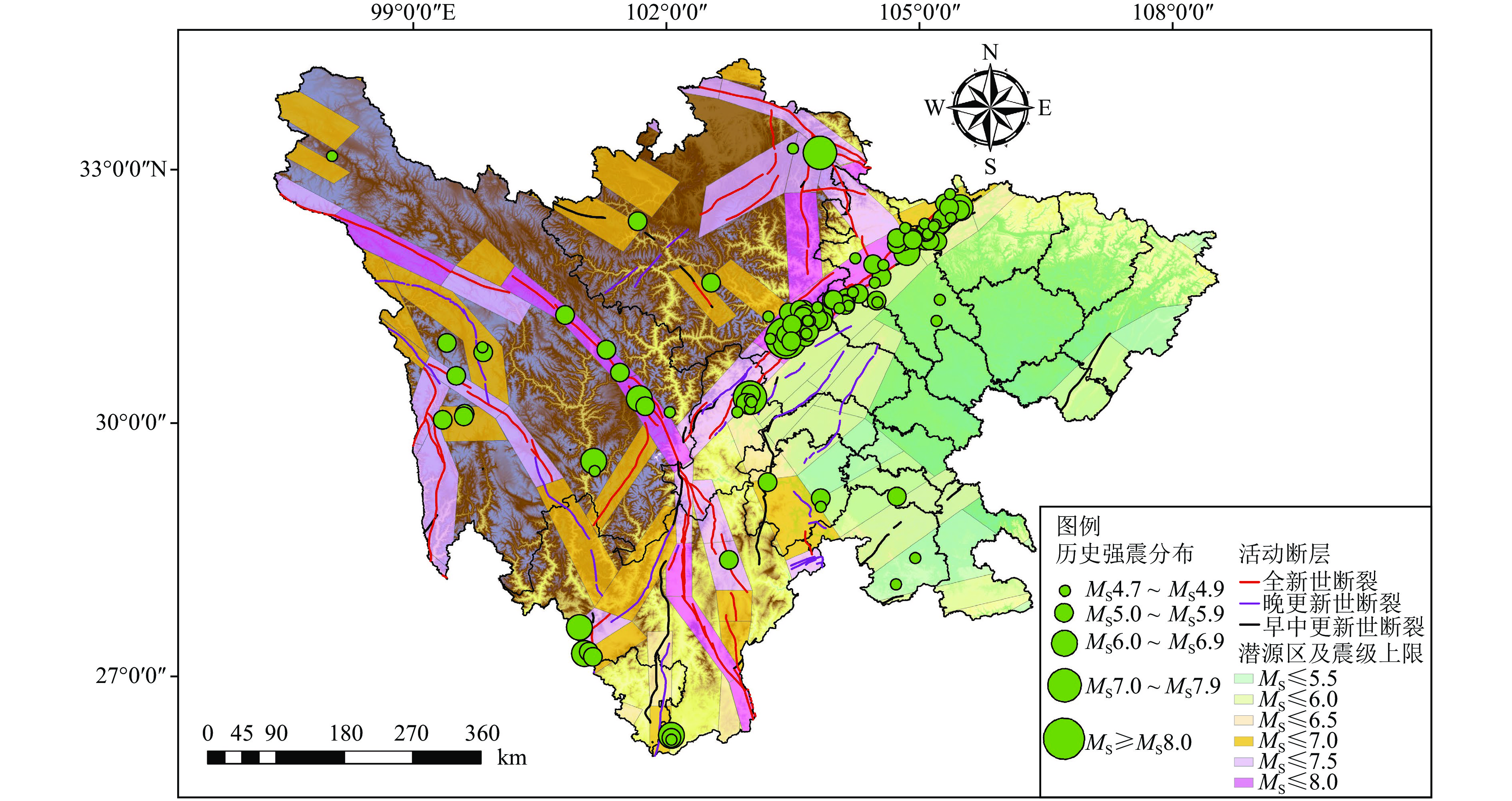
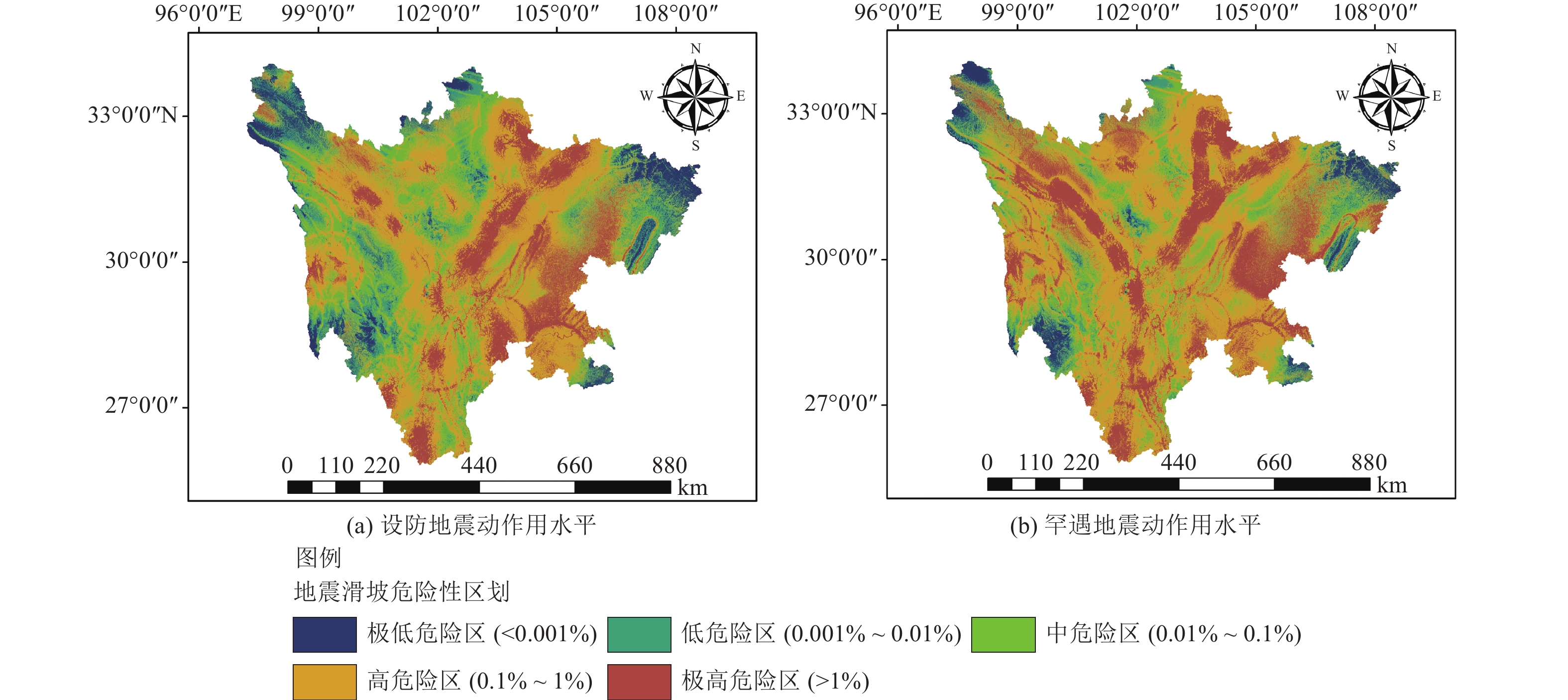
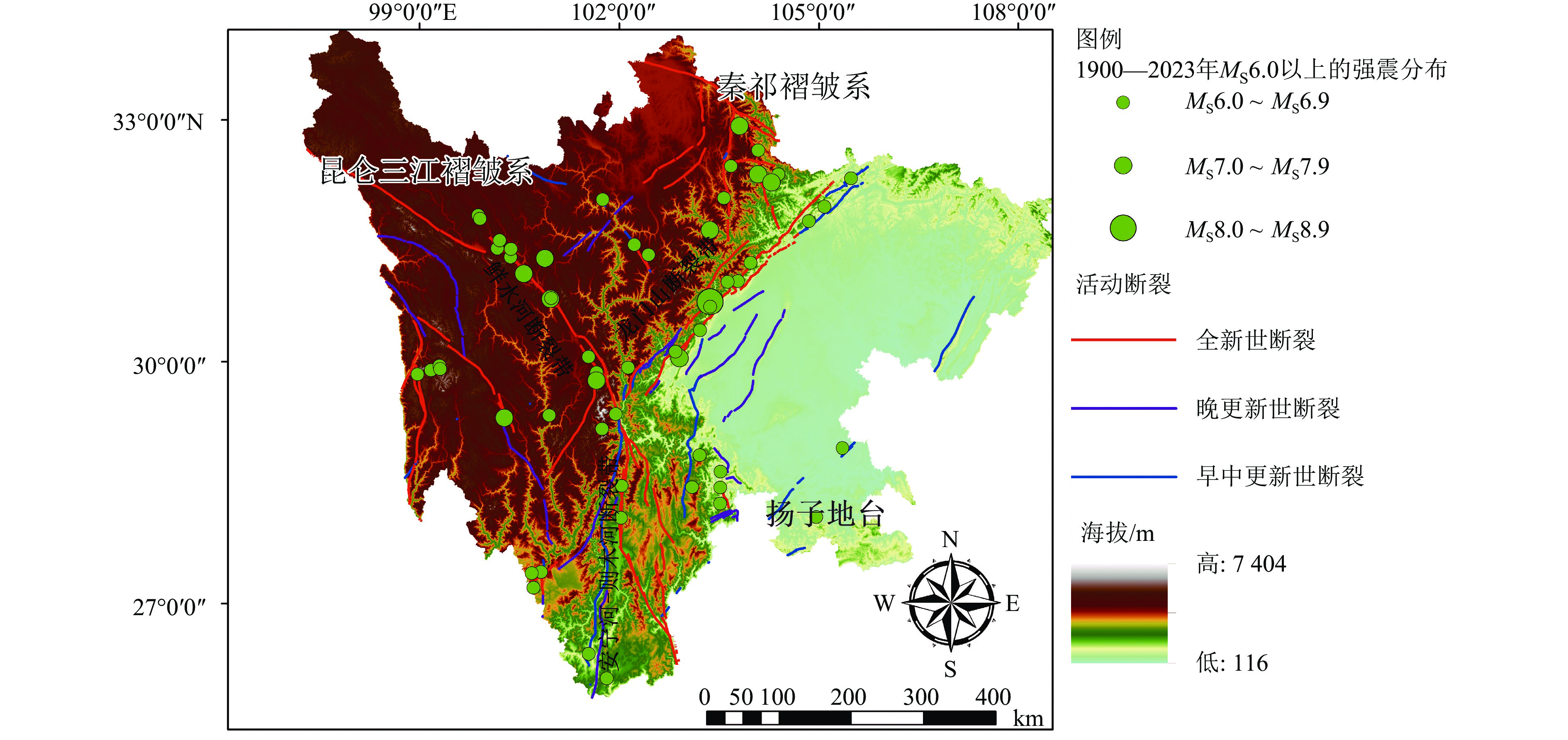
图 2 潜源分布及震源上限
Figure 2. The distribution of potential earthquake source and the upper limit of seismic source
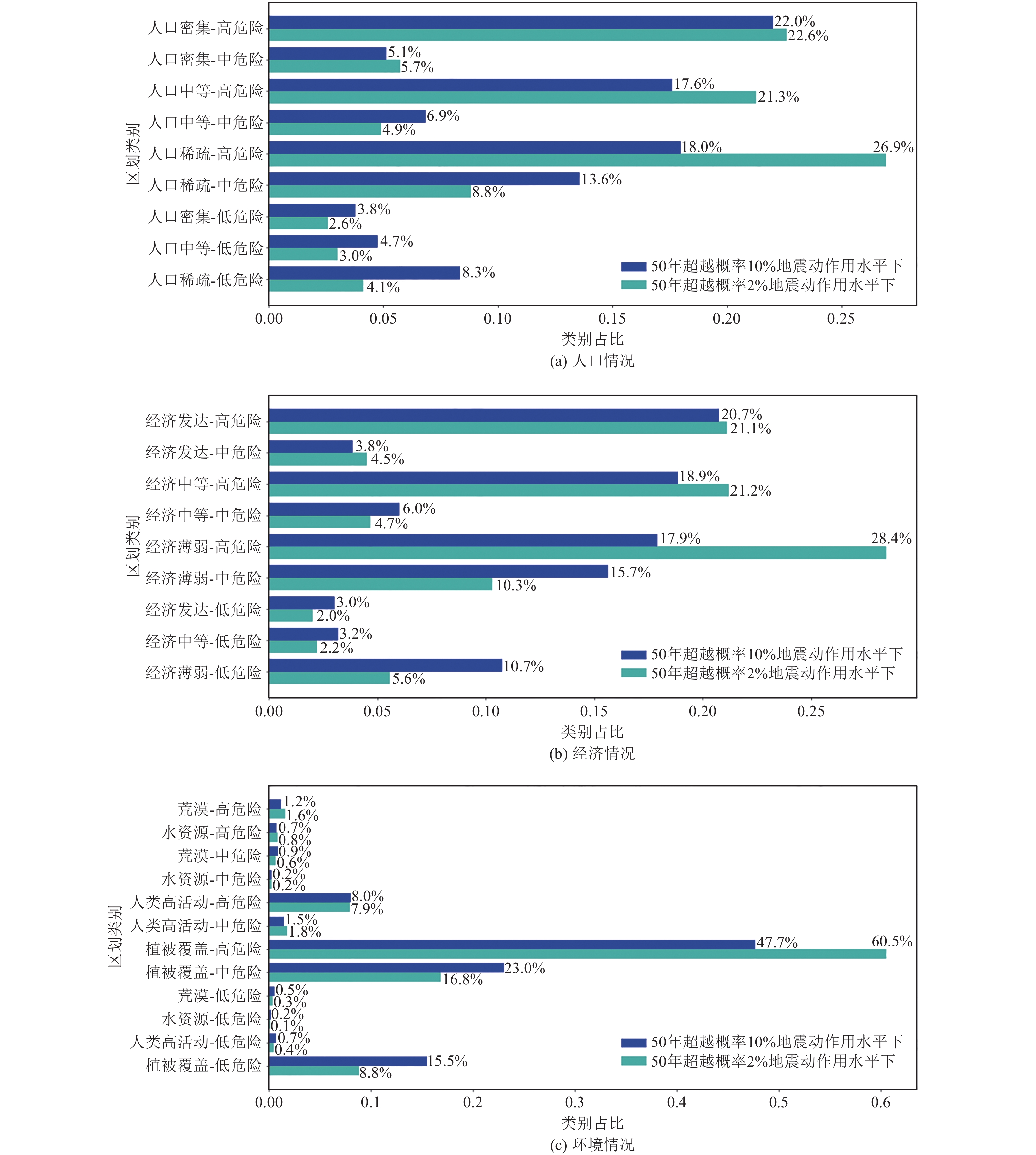
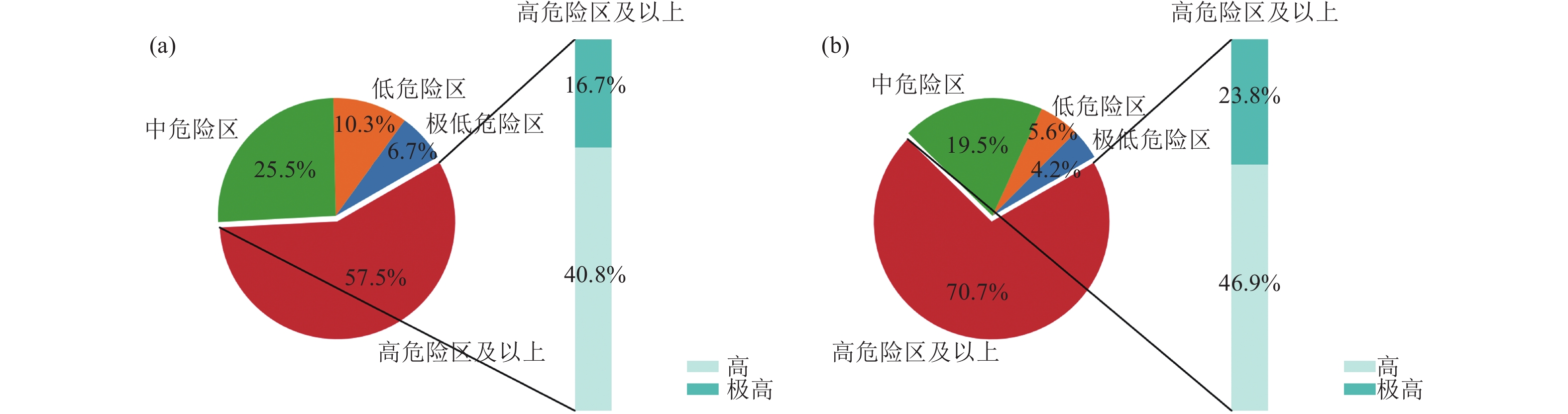
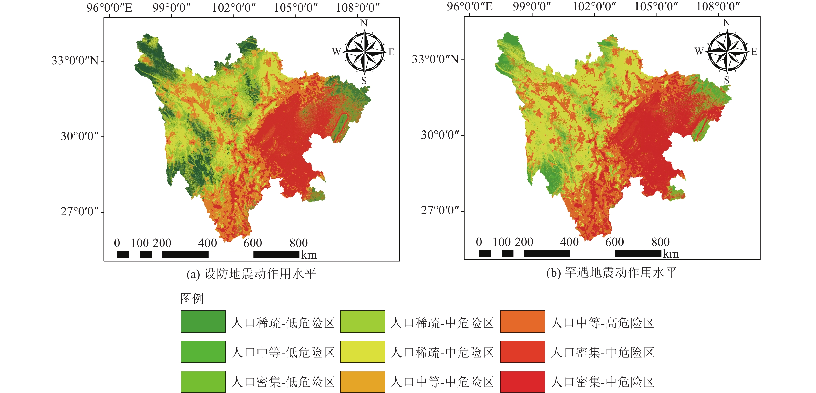
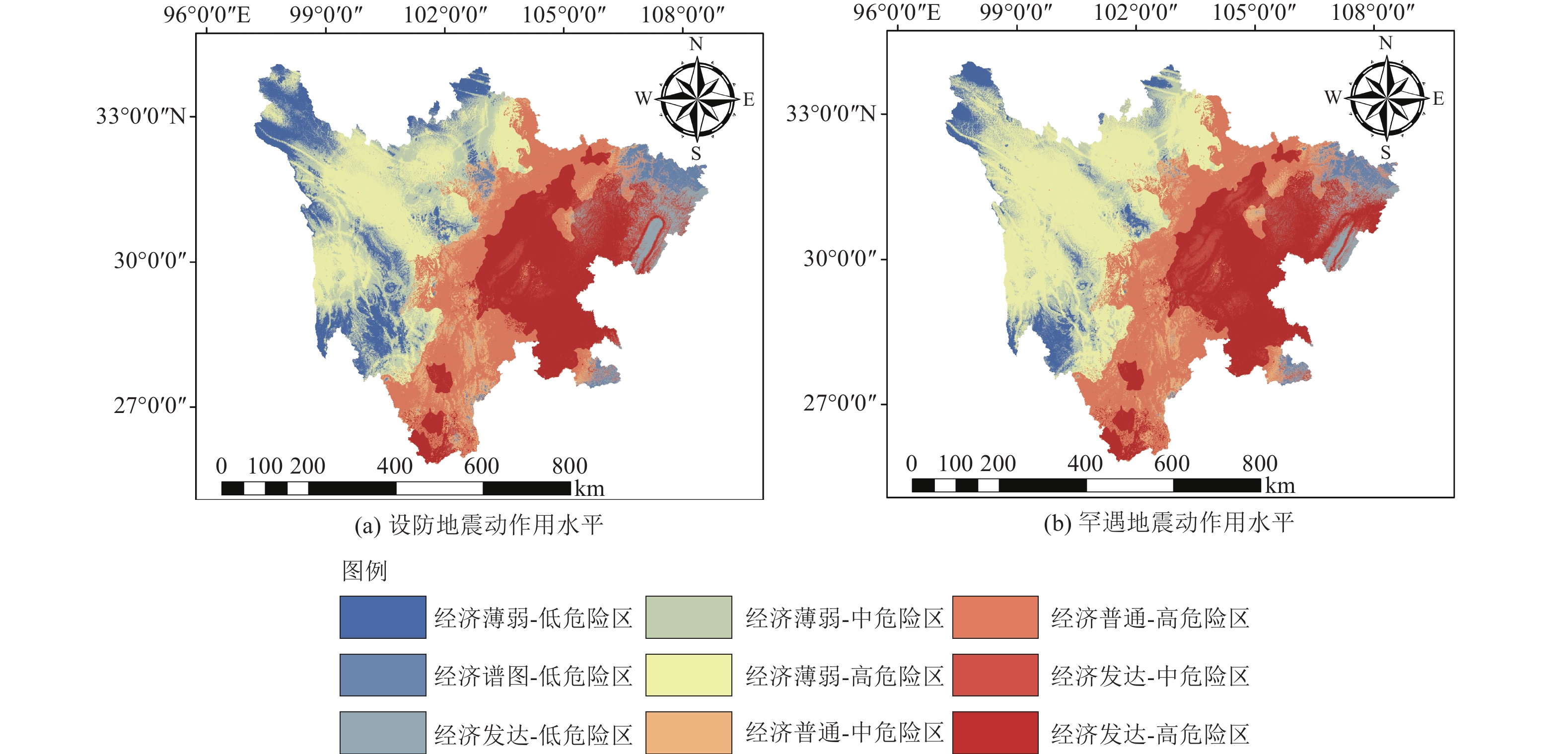
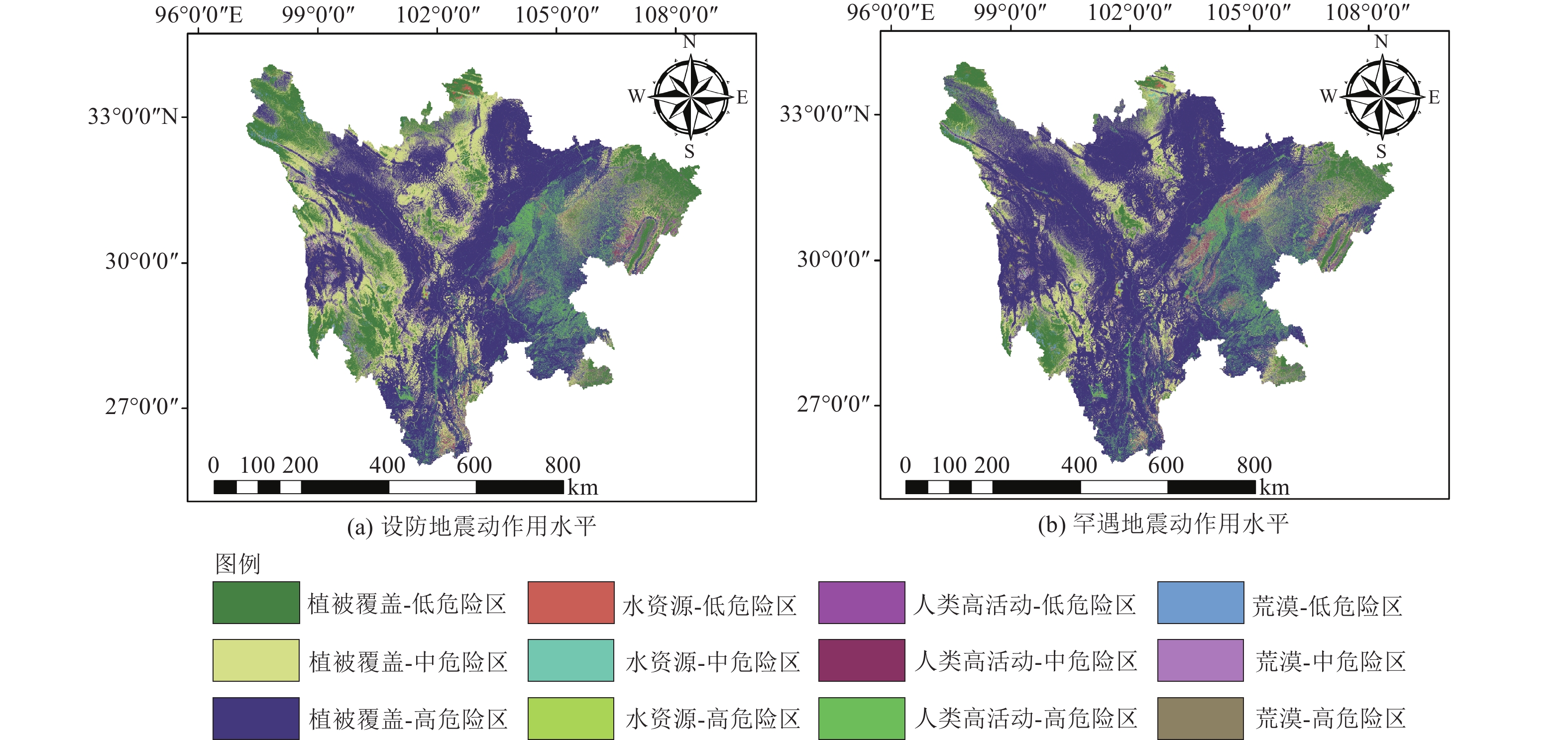
图 13 不同人类活动因素的危险性占比统计
Figure 13. Statistics of hazard ratios for different anthropogenic factors
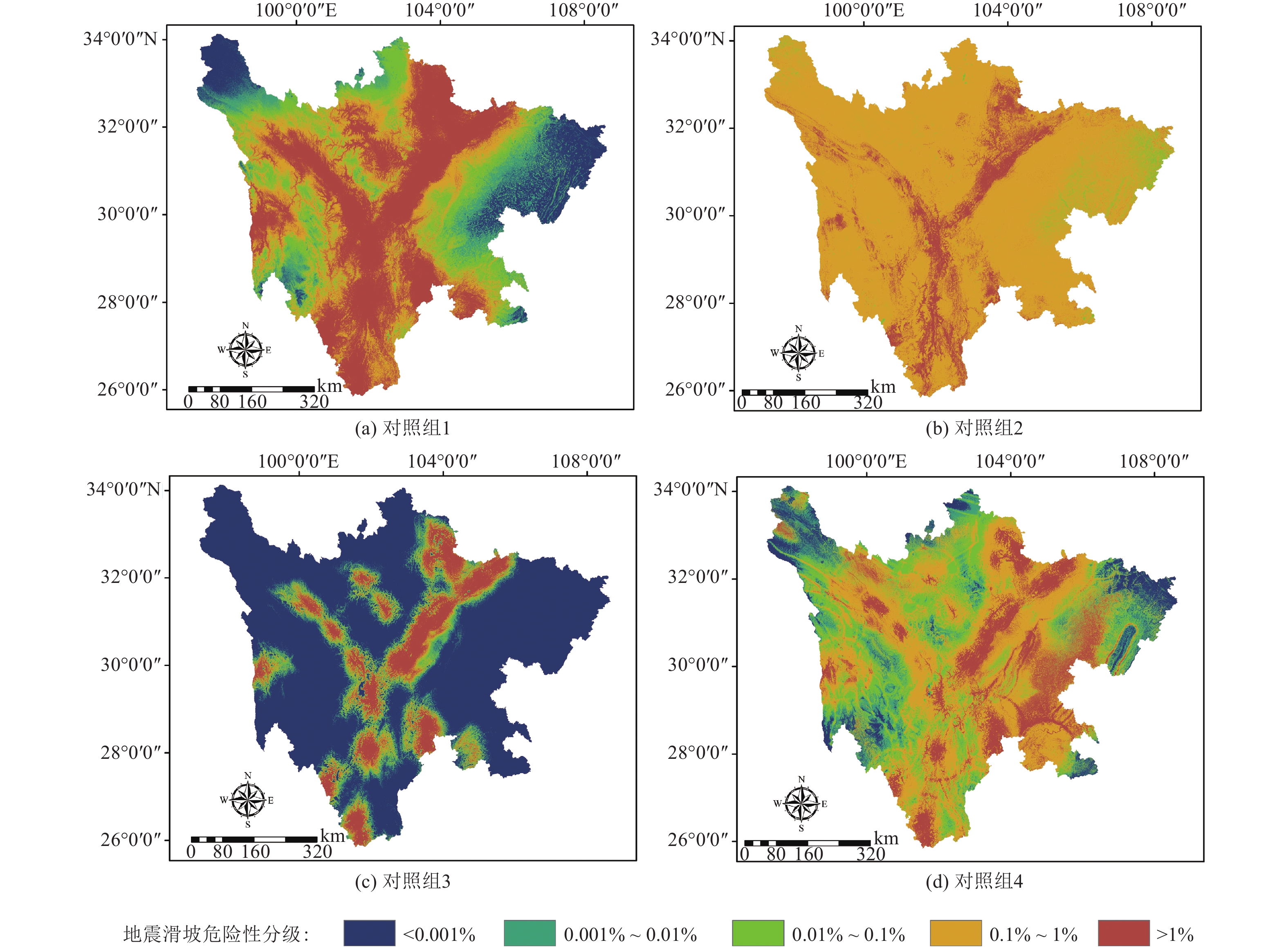
图 14 各采样方法下的地震滑坡危险性
Figure 14. Seismic landslide hazard with different sampling methods
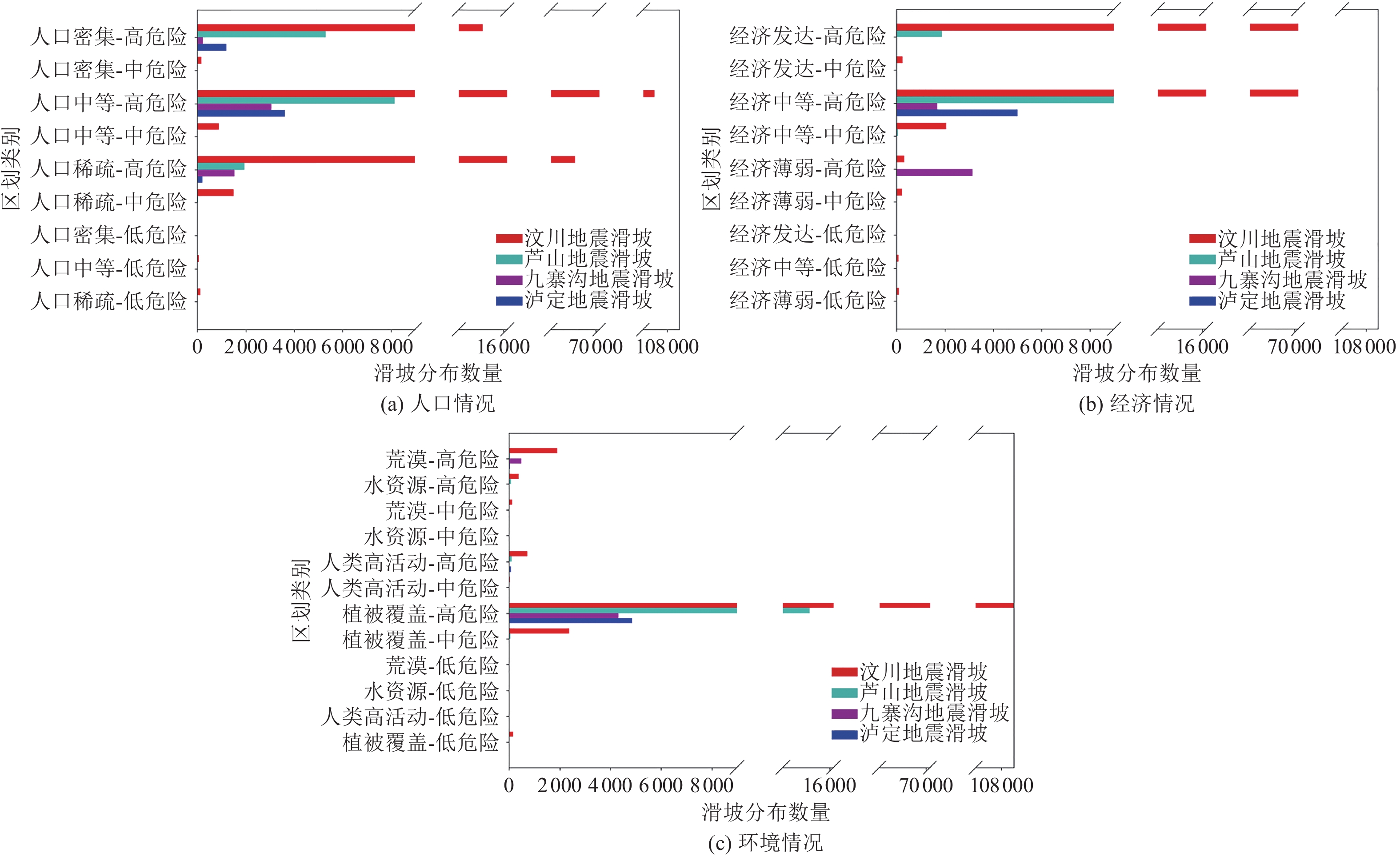
图 15 简化风险分区内的各地震滑坡分布
Figure 15. The distribution of seismic landslides in the simplified risk zoning
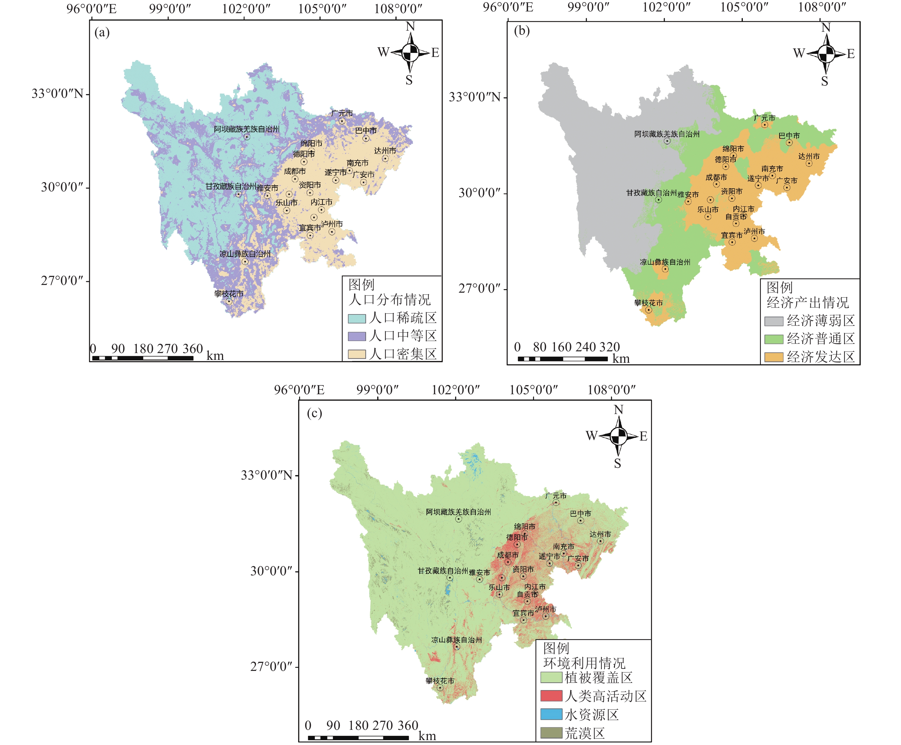
表 1 人类活动因素
Table 1. Human factors
人类活动
因素数据来源 处理方法 人口 开放空间人口数据与研究-人口密度:无约束独立国家
2000—2020年(校正版)(1km分辨率)https://hub.worldpop.org/geodata/listing?id=77 对四川区域内的最新一年(2020年)人口密度栅格取ln(x+1)变换,并根据自然间断点法划分为人口密集区、人口中等区、人口稀疏区3个区间。 经济 中国历史GDP空间分布公里网格数据集(1990—2015年) https://poles.tpdc.ac.cn/zh-hans/data/c91fd466-1f60-4bdb-8cdb-de6f663b0ae7/ 对四川区域内最新一年GDP数值取ln(x+1)变换,并根据自然间断点法划分为经济发达区、经济普通区、经济薄弱区3个区间。 环境 2021年全球10m分辨率土地覆被数据集 https://doi.org/10.5281/zenodo.7254221 将土地覆被数据集的各类别进行重分类,分别为:植被覆盖区(林地、灌木、草地、苔藓)、人类高活动区(耕地、建筑)、水资源区(冰雪、水体、湿地)、荒漠地区。  下载: 导出CSV
表 2 地震滑坡相关的影响因子数据
Table 2. Data of impact factors related to earthquake landslides
序号 影响因子 坐标系 精度 来源 ① 海拔 WGS84 12.5 m ALOS-12.5 m数据 https://search.asf.alaska.edu/#/?dataset=ALOS ② 坡度 ③ 坡向 ④ 曲率 ⑤ 平面曲率 ⑥ 剖面曲率 ⑦ 到断层线的距离 WGS84 — 全国活动断层矢量数据 https://data.earthquake.cn/datashare/report.shtml?PAGEID=datasourcelist&dt=ff808082845b8fd401845bf036a1000c ⑧ 到河流的距离 CGCS2000 1:25万 1:25万全国基础地理数据(2019公众版) https://www.webmap.cn/commres.do?method=result25W ⑨ 到道路的距离 ⑩ 到居民地的距离 ⑪ 人口密度 — — Unconstrained individual countries 2000—2020 UN adjusted(1 km分辨率) https://hub.worldpop.org/geodata/listing?id=77 ⑫ 降水量 WGS84 1 km PRCP1980—2012年平均降水 https://data.casearth.cn/sdo/detail/5c19a5630600cf2a3c557a24 ⑬ 地层岩性 Beijing1954 1:20万 全国1∶200 000数字地质图(公开版)空间数据库 http://dcc.ngac.org.cn/cn//geologicalData/details/doi/10.23650/data.A.2019.NGA120157.K1.1.1.V1 ⑭ 土壤类型 China_Lambert_
Conformal_Conic1 km 中国土壤类型空间分布数据 https://www.resdc.cn/data.aspx?DATAID=145 ⑮ 地震动峰值加速度 CGCS2000 0.05° 中国地震动参数区划图 https://www.gb18306.net/ ⑯ 到历史震中的距离 CGCS2000 — 全国第五代地震动参数区划图地震目录(截至2010年12月底) https://www.gb18306.net/method 中国地震台网https://www.ceic.ac.cn/history
下载: 导出CSV
表 3 斯皮尔曼相关性系数表
Table 3. Spearman's correlation coefficients
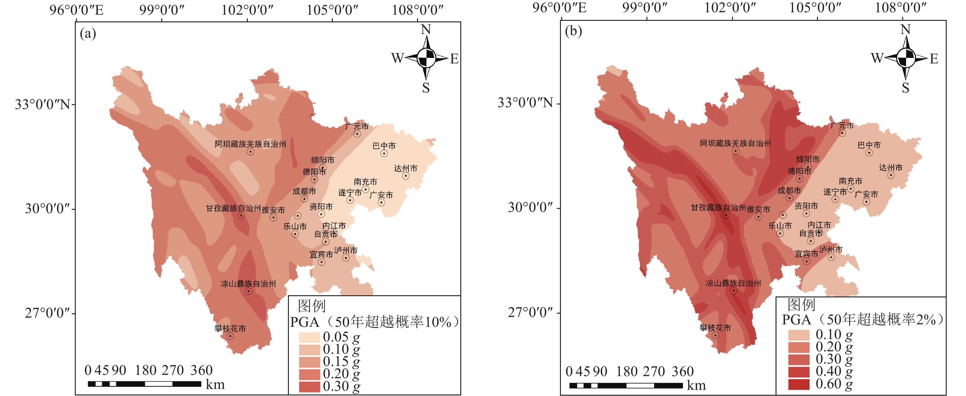
因子序号 ① ② ③ ④ ⑤ ⑥ ⑦ ⑧ ⑨ ⑩ ⑪ ⑫ ⑬ ⑭ ⑮ ⑯ ① 1 0.355 −0.014 0.04 0.02 −0.039 0.273 0.279 0.567 0.631 −0.76 0.407 −0.098 −0.253 0.27 0.07 ② 1 −0.042 0.011 0.014 −0.002 −0.046 0.076 0.297 0.275 −0.368 0.135 0.014 −0.179 0.293 −0.162 ③ 1 −0.008 −0.01 0.002 0.015 0.017 −0.028 −0.026 0.019 −0.033 0.013 0.01 0.002 0.014 ④ 1 0.836 −0.871 0.01 0.064 0.021 0.009 −0.01 0.009 0.003 0.008 −0.006 0.011 ⑤ 1 −0.508 0.01 0.026 −0.002 −0.005 −0.004 −0.007 0.012 0.014 −0.012 0.011 ⑥ 1 −0.003 −0.071 −0.025 −0.013 0.01 −0.017 0.006 −0.008 −0.001 −0.008 ⑦ 1 0.03 0.085 0.099 −0.195 −0.081 0.033 −0.071 −0.38 0.426 ⑧ 1 0.256 0.162 −0.131 0.087 0.042 −0.049 0.052 −0.018 ⑨ 1 0.669 −0.6 0.379 −0.17 −0.234 0.255 −0.12 ⑩ 1 −0.661 0.536 −0.224 −0.158 0.297 −0.145 ⑪ 1 −0.428 0.079 0.248 −0.231 0.087 ⑫ 1 −0.377 −0.031 0.1 −0.123 ⑬ 1 −0.014 −0.102 0.126 ⑭ 1 −0.153 −0.041 ⑮ 1 −0.502 ⑯ 1 注:因子序号与表2序号对应,PGA因子选用50年超越概率10%的地震动,表中黑体数值为超过阈值的相关系数。
下载: 导出CSV
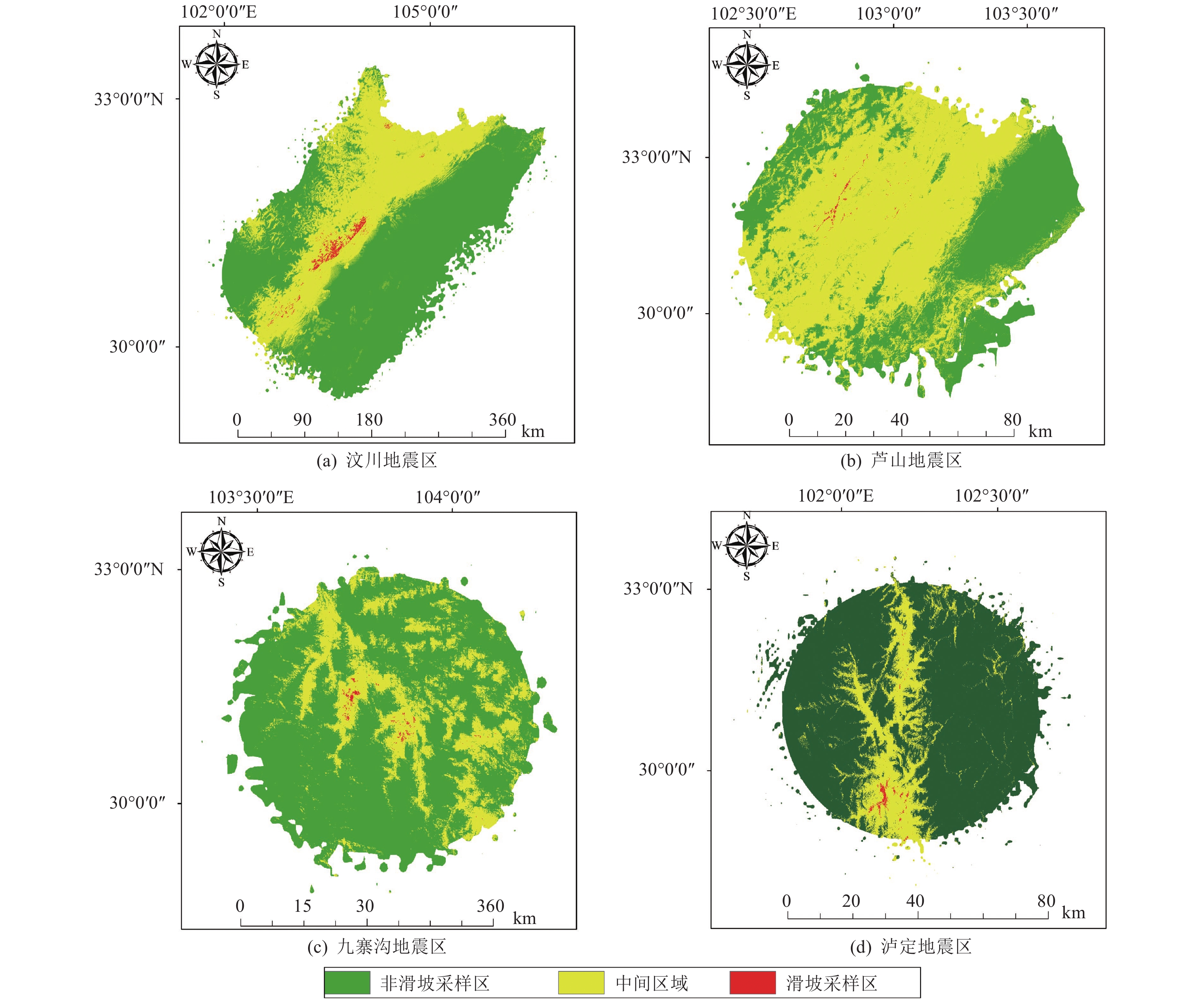
表 4 各地震区采样情况
Table 4. Sampling situation of each earthquake area
地震事件 滑坡总数 地震烈度VII(PGA≥0.1 g) 滑坡样本 非滑坡样本 滑坡采样区/km2
(可靠度)非滑坡采样区/km2
(可靠度)滑坡面积/km2 取样面积/km2 滑坡面积/
取样面积汶川地震 197481 2899 247101 789.38(> 0.86) 64051.2 (< 0.5)1160.33526 99939.05 0.01161 芦山地震 15463 494 249506 15.18(> 0.89) 3741.72 (< 0.5)18.36946 9294.234 0.00198 九寨沟地震 4834 634 249366 9.89(> 0.80) 2955.5 (< 0.5)9.63971 3875.996 0.00249 泸定地震 5007 814 249186 18.82(> 0.80) 4173.81 (< 0.5)16.84592 5182.563 0.00325
下载: 导出CSV
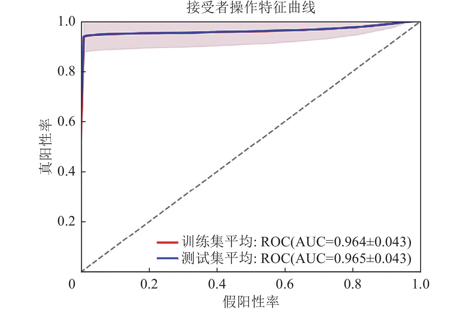
表 5 交叉验证结果
Table 5. Cross-validation results
项目 评价指标 第1折 第2折 第3折 第4折 第5折 平均结果 AUC(训练集) 0.99913 0.91724 0.90557 0.99974 0.99912 0.96416 AUC(测试集) 0.99855 0.92144 0.9043 0.99974 0.99911 0.96463
下载: 导出CSV
表 6 不同采样方法对比
Table 6. Comparison of different sampling methods
地震事件 滑坡样本 滑坡样本数÷非滑坡样本数 对照组1
(基于面要素提取)对照组2
(基于面要素提取)对照组3
(基于有可靠度的采样区)对照组4
(基于有可靠度的采样区)汶川地震 2899 1 0.01173 1 0.01173 (滑坡:> 0.86;非滑坡:<0.5) 芦山地震 494 1 0.00198 1 0.00198 (滑坡:> 0.89;非滑坡:<0.5) 九寨沟地震 634 1 0.00254 1 0.00254 (滑坡:> 0.80;非滑坡:<0.5) 泸定地震 814 1 0.00327 1 0.00327 (滑坡:> 0.80;非滑坡:<0.5)
下载: 导出CSV
表 7 使用不同采样方法的模型测试集检验结果
Table 7. Test results of model test set using different sampling methods
对照组 准确率 精确率 召回率 F1 AUC 1 0.76111 0.67814 0.99488 0.80628 0.95204 2 0.97366 0.10667 0.59739 0.18071 0.95367 3 0.96509 0.93539 0.99958 0.96633 0.99903 4 0.98967 0.32315 0.94133 0.47679 0.96463
下载: 导出CSV
-
艾骁, 张健, 付济民, 2024. 不同特征选择方法于区域地震滑坡危险性预测结果的差异性分析−以汶川地震区为例. 华南地震, 44(2): 39−51.Ai X., Zhang J. Fu J. M., 2024. Difference in regional seismic landslide risk prediction results based on different feature selection methods−A case study of Wenchuan earthquake area. South China Journal of Seismology, 44(2): 39−51. (in Chinese) 陈若珠, 闫小喜, 李战明, 2007. 基于减聚类的T-S模糊控制器规则提取及优化方法. 见: 2007年中国智能自动化会议论文集. 兰州: 中国自动化学会智能自动化专业委员会, 92−96. 陈晓利, 2007. 人工智能在地震滑坡危险性评价中的应用. 北京: 中国地震局地质研究所.Chen X. L., 2007. Application of artificial intelligence to assessment of earthquake-induced landslide susceptibility. Beijing: Institute of Geology, China Earthquake Administration. (in Chinese) 范宣梅, 王欣, 戴岚欣等, 2022. 2022年MS6.8级泸定地震诱发地质灾害特征与空间分布规律研究. 工程地质学报, 30(5): 1504−1516.Fan X. M., Wang X., Dai L. X., et al., 2022. Characteristics and spatial distribution pattern of MS6.8 Luding Earthquake occurred on September 5, 2022. Journal of Engineering Geology, 30(5): 1504−1516. (in Chinese) 高孟潭, 2015. GB 18306-2015《中国地震动参数区划图》宣贯教材. 北京: 中国质检出版社. 洪浩源, 王德生, 朱阿兴, 2024. 面向机器学习型区域滑坡易发性评价的训练样本采样方法. 地理学报, 79(7): 1718−1736.Hong H. Y., Wang D. S., Zhu A. X., 2024. A new training data sampling method for machine learning-based landslide susceptibility mapping. Acta Geographica Sinica, 79(7): 1718−1736. (in Chinese) 罗改, 王全伟, 秦宇龙等, 2021. 四川省大地构造单元划分及其基本特征. 沉积与特提斯地质, 41(4): 633−647.Luo G., Wang Q. W., Qin Y. L., et al., 2021. Divisions and their basic characteristics of tectonic units in Sichuan Province. Sedimentary Geology and Tethyan Geology, 41(4): 633−647. (in Chinese) 马思远, 许冲, 田颖颖等, 2019. 基于逻辑回归模型的九寨沟地震滑坡危险性评估. 地震地质, 41(1): 162−177.Ma S. Y., Xu C., Tian Y. Y., et al., 2019. Application of logistic regression model for hazard assessment of earthquake-triggered landslides: a case study of 2017 Jiuzhaigou(China) MS7.0 event. Seismology and Geology, 41(1): 162−177. (in Chinese) 缪亚敏, 朱阿兴, 杨琳等, 2016. 滑坡危险度评价对BCS负样本采样的敏感性. 山地学报, 34(4): 432−441.Miao Y. M., Zhu A. X., Yang L., et al., 2016. Sensitivity of BCS for sampling landslide absence data in landslide susceptibility assessment. Mountain Research, 34(4): 432−441. (in Chinese) 钱紫玲, 王平, 李娜等, 2023. 基于信息量和逻辑回归耦合模型的黄土地震滑坡危险性分析. 地震工程学报, 45(3): 706−715.Qian Z. L., Wang P., Li N., et al., 2023. Risk analysis of loess seismic landslides based on an information value-logistic regression coupling model. China Earthquake Engineering Journal, 45(3): 706−715. (in Chinese) 四川年鉴社, 2019. 土地资源. (2019-06-25)[2024-07-31]. https://www.sc.gov.cn/10462/10778/10876/2019/6/25/c84ef994e3204d428af985457e59c41a.shtml. 四川省地震应急服务中心, 2022. 四川的强震及其分布. (2022-01-25)[2023-08-22]. https://www.scdzj.gov.cn/dzpd/dzkp/202201/t20220125_51277.html. 田尤, 高波, 殷红等, 2024. 滑坡易发性评价中样本不均衡问题处理研究. 水文地质工程地质, 51(6)171−181.Tian Y., Gao B., Yin H., et al., 2024. Handling imbalanced samples in landslide susceptibility evaluation. Hydrogeology & Engineering Geology, 51(6): 171−181. (in Chinese) 许冲, 徐锡伟, 周本刚等, 2019. 同震滑坡发生概率研究−−新一代地震滑坡危险性模型. 工程地质学报, 27(5): 1122−1130.Xu C., Xu X. W., Zhou B. G., et al., 2019. Probability of coseismic landslides: A new generation of earthquake-triggered landslide hazard model. Journal of Engineering Geology, 27(5): 1122−1130. (in Chinese) 杨华阳, 许向宁, 杨鸿发, 2020. 基于证据权法的九寨沟地震滑坡危险性评价. 中国地质灾害与防治学报, 31(3): 20−29.Yang H. Y., Xu X. N., Yang H. F., 2020. The Jiuzhaigou co-seismic landslide hazard assessment based on weight of evidence method. The Chinese Journal of Geological Hazard and Control, 31(3): 20−29. (in Chinese) 杨涛, 邓荣贵, 刘小丽, 2002. 四川地区地震崩塌滑坡的基本特征及危险性分区. 山地学报, 20(4): 456−460.Yang T., Deng R. G., Liu X. L., 2002. The distributing and subarea character of the seismic landslides in Sichuan. Journal of Mountain Science, 20(4): 456−460. (in Chinese) 于海坤, 欧阳九发, 王丙千等, 2024. 不同采样策略下的区域滑坡易发性评价. 安全与环境工程, 31(5): 122−134, 162.Yu H. K., Ouyang J. F., Wang B. Q., et al., 2024. Susceptibility assessment of regional landslides under different sampling strategies. Safety and Environmental Engineering, 31(5): 122−134,162. (in Chinese) 张化光, 何希勤, 2002. 模糊自适应控制理论及其应用. 北京: 北京航空航天大学出版社. 张迎宾, 徐佩依, 林剑锋等, 2024. 基于BP神经网络的九寨沟地区地震滑坡危险性预测研究. 工程地质学报, 32(1): 133−145.Zhang Y. B., Xu P. Y., Lin J. F., et al., 2024. Earthquake-triggered landslide susceptibility prediction in Jiuzhaigou based on BP neural network. Journal of Engineering Geology, 32(1): 133−145. (in Chinese) 祖家奎, 戴冠中, 张骏, 2002. 基于聚类算法的神经模糊推理系统结构和参数的优化. 系统仿真学报, 14(4): 501−503.Zu J. K., Dai G. Z., Zhang J., 2002. Structure and parameters optimization of neural-fuzzy inference system via clustering algorithm. Journal of System Simulation, 14(4): 501−503. (in Chinese) Dai L. X., Fan X. M., Wang X., et al., 2023. Coseismic landslides triggered by the 2022 Luding MS6.8 earthquake, China. Landslides, 20(6): 1277−1292. doi: 10.1007/s10346-023-02061-3 Hong H. Y., Wang D. S., Zhu A. X., et al., 2024. Landslide susceptibility mapping based on the reliability of landslide and non-landslide sample. Expert Systems with Applications, 243: 122933. doi: 10.1016/j.eswa.2023.122933 Huang Y. D., Xie C. C., Li T., et al., 2023. An open-accessed inventory of landslides triggered by the MS6.8 Luding earthquake, China on September 5, 2022. Earthquake Research Advances, 3(1): 100181. doi: 10.1016/j.eqrea.2022.100181 Jang J. S. R. , 1993. ANFIS: adaptive-network-based fuzzy inference system. IEEE Transactions on Systems, Man, and Cybernetics, 23(3): 665−685. Jin J. L., Cui Y. L., Xu C., et al., 2023. Application of logistic regression model for hazard assessment of landslides caused by the 2012 Yiliang MS5.7 earthquake in Yunnan Province, China. Journal of Mountain Science, 20(3): 657−669. doi: 10.1007/s11629-022-7698-6 Karaboga D., Kaya E., 2019. Adaptive network based fuzzy inference system (ANFIS) training approaches: a comprehensive survey. Artificial Intelligence Review, 52(4): 2263−2293. doi: 10.1007/s10462-017-9610-2 Khalil Y. M., Al-Masnay Y. A., Al-Areeq N. M., et al., 2024. Estimating landslide hazard distribution based on machine learning and bivariate statistics in Utmah region, Yemen. Natural Hazards, 120(3): 2869−2907. doi: 10.1007/s11069-023-06310-5 Pham Q. B., Ekmekcioğlu Ö., Ali S. A., et al., 2023. Examining the role of class imbalance handling strategies in predicting earthquake-induced landslide-prone regions. Applied Soft Computing, 143: 110429. doi: 10.1016/j.asoc.2023.110429 Shao X. Y., Ma S. Y., Xu C., et al., 2023. Seismically-induced landslide probabilistic hazard mapping of Aba prefecture and Chengdu plain region, Sichuan province, China for future seismic scenarios. Geoscience Letters, 10(1): 55. doi: 10.1186/s40562-023-00307-5 Tian Y. Y., Xu C., Ma S. Y., et al., 2019. Inventory and spatial distribution of landslides triggered by the 8th August 2017 MW6.5 Jiuzhaigou earthquake, China. Journal of Earth Science, 30(1): 206−217. doi: 10.1007/s12583-018-0869-2 Werbos P. J. , 1974. Beyond regression: new tools for prediction and analysis in the behavioral sciences. Cambridge: Harvard University. Xu C., Xu X. W., Yao X., et al., 2014. Three (nearly) complete inventories of landslides triggered by the May 12, 2008 Wenchuan MW7.9 earthquake of China and their spatial distribution statistical analysis. Landslides, 11(3): 441−461. doi: 10.1007/s10346-013-0404-6 Xu C., Xu X. W., Shyu J. B. H., 2015. Database and spatial distribution of landslides triggered by the Lushan, China MW6.6 earthquake of 20 April 2013. Geomorphology, 248: 77−92. doi: 10.1016/j.geomorph.2015.07.002 Yue J. H. , Liu J. Z. , Liu X. J. , et al. , 2006. Identification of nonlinear system based on ANFIS with subtractive clustering. In: 2006 6th World Congress on Intelligent Control and Automation. Dalian: IEEE, 1852−1856. -


 点击查看大图
计量
- 文章访问数: 292
- HTML全文浏览量: 135
- PDF下载量: 70
- 被引次数: 0
