
The Key Technology Research of Drone Live Broadcast in Earthquake Disaster Acquisition
-
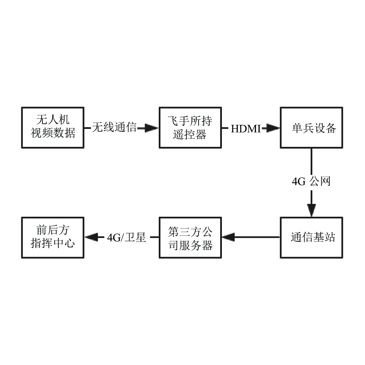
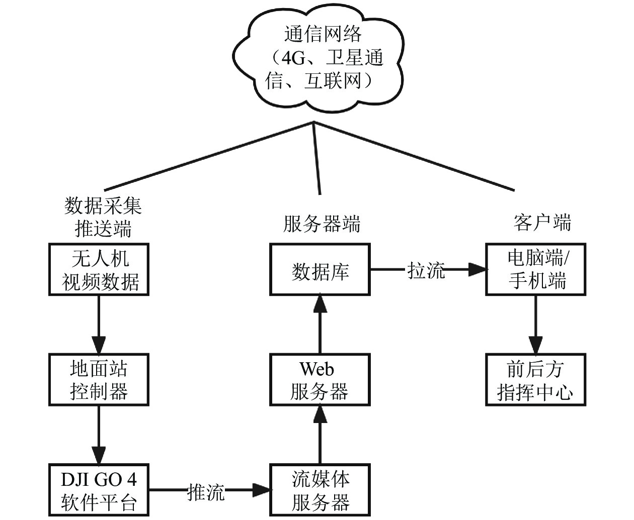
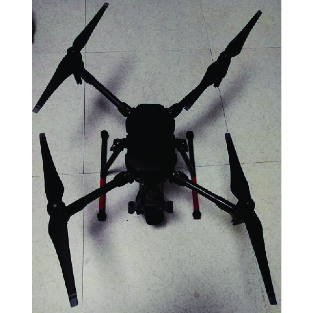
摘要: 近年来国内多次地震应急经验表明,在震后第一时间获取灾情信息是公共服务的关键,能够有效减轻地震灾害带来的损失,因此快速获取灾情信息并制定合理的救援策略成为减轻灾害的有效方法。无人机灾情获取技术可与传统灾情获取手段相互融合,在多次地震应急中取得了良好的效果。针对单兵系统依赖的远端服务器稳定性差、本地布设的服务器价格高、展示渠道单一等问题,本文研究了基于无人机视频传输快速获取震后现场灾情信息的方法,有助于完善现有灾情信息获取手段。无人机直播技术采用实时消息传输协议,在云服务器中设定推流、拉流对应地址,将采集的图像信息推流至云服务器,实现数据的拉流,现场灾情信息可同时在前后方电脑端、手机端显示。当网络中断时,利用现场应急通信车的卫星组网功能,仍可将灾情信息回传至后方指挥大厅。Abstract: In recent years, many domestic earthquake emergency response experiences have shown that obtaining disaster information immediately after an earthquake is the key to public services, and can effectively reduce losses from disasters. Therefore, obtaining disaster information quickly and formulating reasonable rescue strategies have become the most effective ways for disaster reduction. The drone disaster acquisition technology integrating with the traditional disaster acquisition method has achieved good application results in many emergency situations. In view of the series of problems, such as the poor remote server stability relied by individual soldier system, the expensive local server, and the single display channel, we propose a method to quickly obtain post-earthquake disaster information through drone video transmission, which is helpful for improving the existing means of disaster acquisition. First, real-time message transmission protocol streaming in drone live broadcast technology sets the corresponding addresses of push and pull streams in the cloud server, and then pushes the collected image information to the cloud server, and then realizes the pull stream of data, which can be simultaneously displayed on the computers and mobile phones in front and back sides. When the network is interrupted, the system can still transmit disaster information back to the command hall by using the satellite networking function of the on-site emergency communication vehicle.
-
Key words:
- Disaster acquisition /
- Drone live broadcast /
- Data transmission /
- Cloud server
-
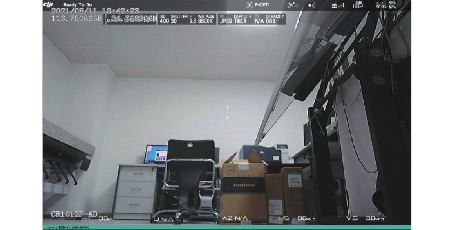
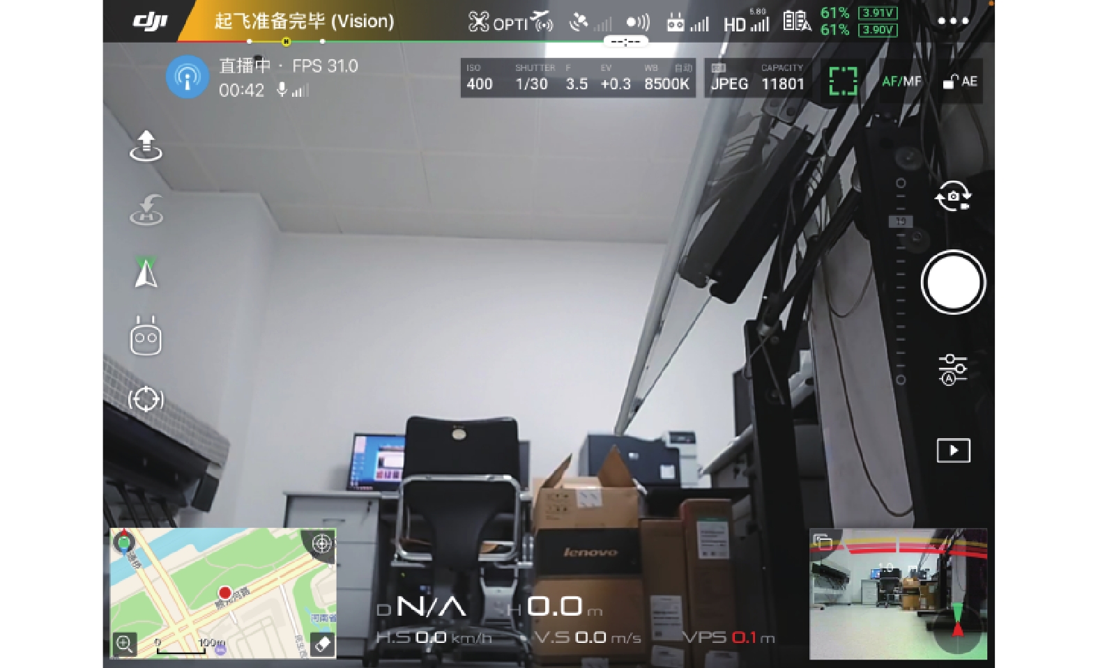
图 6 单兵图传系统回传画面
Figure 6. The picture returned by individual soldier map transmission system
表 1 播放协议及前缀对比
Table 1. Comparison of broadcast protocol and prefix
播放协议 播放前缀 备注 WebRTC webrtc:// 秒开效果最好,支持超高并发 HTTP-FLV http://或https:// 秒开效果较好,支持超高并发 RTMP rtmp:// 秒开效果差,不支持高并发  下载: 导出CSV
-
陈楠, 宋智礼, 2020. 无人机自主飞行精确定位导航在环境安全中的应用. 现代电子技术, 43(2): 97—100, 105Chen N. , Song Z. L. , 2020. Application of UAV autonomous flight precise positioning navigation in environmental safety. Modern Electronics Technique, 43(2): 97—100, 105. (in Chinese) 杜强, 2019. 基于无人机摄影的地震形变场测量技术研究. 华南地震, 39(2): 118—123Du Q. , 2019. Research on seismic deformation field measurement technology based on UAV photography. South China Journal of Seismology, 39(2): 118—123. (in Chinese) 郭建兴, 袁小祥, 韶丹, 2018. 基于“数字地球”的无人机遥感地震应急系统研制. 信息通信, (8): 65—68Guo J. X. , Yuan X. X. , Shao D. , 2018. Development of unmanned aerial vehicle remote sensing earthquake emergency system based on Digital Earth Platform. Information & Communications, (8): 65—68. (in Chinese) 黄恩钊, 何萍, 王挺等, 2018. 基于指挥系统的无人机在灾情快速获取中的应用. 华南地震, 38(S1): 53—56Huang E. Z. , He P. , Wang T. , et al. , 2018. Application of UAV based on earthquake command system in rapid disaster acquisition. South China Journal of Seismology, 38(S1): 53—56. (in Chinese) 黄海峰, 易武, 张国栋等, 2017. 引入小型无人机遥感的滑坡应急治理勘查设计方法. 防灾减灾工程学报, 2017, 37(1): 99—104Huang H. F. , Yi W. , Zhang G. D. , et al. , 2017. Method of Using Micro-UAVRS in engineering geological investigation and design for emergency control of landslides. Journal of Disaster Prevention and Mitigation Engineering, 37(1): 99—104. (in Chinese) 牛志, 2017. 以流媒体服务器为核心的无人机4 G直播系统. 广播与电视技术, 44(11): 50—55Niu Z. , 2017. UAV 4 G live broadcasting system based on streaming media server. Radio & TV Broadcast Engineering, 44(11): 50—55. (in Chinese) 石珺, 赛景波, 张楠西等, 2017. 基于RED5无人机直播系统的设计与实现. 国外电子测量技术, 36(8): 100—103 doi: 10.3969/j.issn.1002-8978.2017.08.023Shi J. , Sai J. B. , Zhang N. X. , et al. , 2017. Design and implementation of UAV living system based on RED5. Foreign Electronic Measurement Technology, 36(8): 100—103. (in Chinese) doi: 10.3969/j.issn.1002-8978.2017.08.023 王林, 2016. 无人机在应对地震灾害方面的应用及发展. 中国应急救援, (6): 33—36. doi: 10.19384/j.cnki.cn11-5524/p.2016.06.009 王晓青, 黄树松, 丁香等, 2015. 尼泊尔8.1级地震建筑物震害遥感提取与分析. 震灾防御技术, 10(3): 481—490 doi: 10.11899/zzfy20150301Wang X. Q. , Huang S. S. , Ding X. , et al. , 2015. Extraction and analysis of building damage caused by nepal MS8.1 earthquake from remote sensing images. Technology for Earthquake Disaster Prevention, 10(3): 481—490. (in Chinese) doi: 10.11899/zzfy20150301 王之, 刘超, 刘秀菊等, 2018. 基于SEaTH算法的芦山地震无人机低空遥感影像信息对象级分类. 地震研究, 41(2): 173—179 doi: 10.3969/j.issn.1000-0666.2018.02.003Wang Z. , Liu C. , Liu X. J. , et al. , 2018. Study on the object-based classification of low-altitude UAV remote sensing image of the Lushan earthquake based on the SEaTH algorithm. Journal of Seismological Research, 41(2): 173—179. (in Chinese) doi: 10.3969/j.issn.1000-0666.2018.02.003 温奇, 陈世荣, 和海霞等, 2012. 无人机遥感系统在云南盈江地震中的应用. 自然灾害学报, 21(6): 65—71Wen Q. , Chen S. R. , He H. X. , et al. , 2012. Application of remote sensing system of unmanned aerial vehicle in Yingjiang, Yunnan earthquake. Journal of Natural Disasters, 21(6): 65—71. (in Chinese) 张顺, 赵玉金, 白永飞等, 2019. 基于低空无人机的草原灌丛遥感辨识方法. 热带地理, 39(4): 512—520Zhang S. , Zhao Y. J. , Bai Y. F. , et al. , 2019. Remote sensing identification of grassland shrubs using low-altitude unmanned aerial vehicles. Tropical Geography, 39(4): 512—520. (in Chinese) 张雪华, 王晓青, 杜晓霞等, 2019. 基于无人机遥感影像及其点云特征的建筑物震害提取. 地震研究, 42(2): 230—235Zhang X. H. , Wang X. Q. , Du X. X. , et al. , 2019. Extraction of buildings' seismic damage based on remote sensing images of UAV and its point clouds characteristic. Journal of Seismological Research, 42(2): 230—235. (in Chinese) Xu Z. Q. , Yang J. S. , Peng C. Y. , et al. , 2014. Development of an UAS for post-earthquake disaster surveying and its application in MS7.0 Lushan Earthquake, Sichuan, China. Computers & Geosciences, 68: 22—30. -


 点击查看大图
图(8) / 表(1)
计量
- 文章访问数: 207
- HTML全文浏览量: 57
- PDF下载量: 20
- 被引次数: 0
