
Seismic Damage Analysis of UAV Remote Sensing Images in the Extreme Seismic Zone of the MS6.0 Earthquake in Luxian, Sichuan
-
摘要: 利用无人机平台及倾斜摄影系统对2021年9月16日四川泸县MS6.0地震极震区部分区域进行无人机倾斜摄影,构建了群体建筑物高分辨率三维模型,在此基础上,采用目视解译方法对典型建筑物震害和遇难人员周边环境进行解析,初步分析了本次房屋震害和人员遇难原因,为地震现场震害调查、地震烈度评定及灾情研判提供了参考依据。Abstract: In this paper, the technical process of seismic damage investigation and analysis based on unmanned aerial vehicle (UAV) oblique photography technology is proposed, and the UAV platform and oblique photography system are used to conduct UAV oblique photography in some areas of the MS6.0 earthquake meizoseismal area in Luxian County, Sichuan Province on September 16, 2021. The high-resolution three-dimensional models of group buildings are constructed. On this basis, the visual interpretation method is used to analyze the seismic damage of typical buildings and the surrounding environment of the victims, and the causes of the seismic damage of the buildings and the deaths of the victims are preliminarily analyzed, which provides a reference for the seismic damage investigation, seismic intensity evaluation, and seismic disaster evaluation.1)
1 2https://www.cea.gov.cn/cea/xwzx/fzjzyw/5609043/index.html -
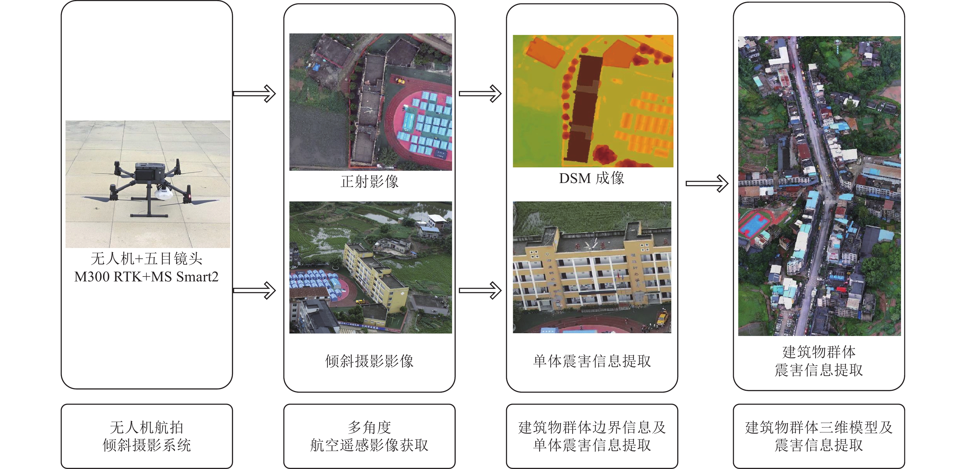
图 2 倾斜摄影震害调查分析技术流程
Figure 2. Workflow of seismic damage investigation and analysis using oblique photography
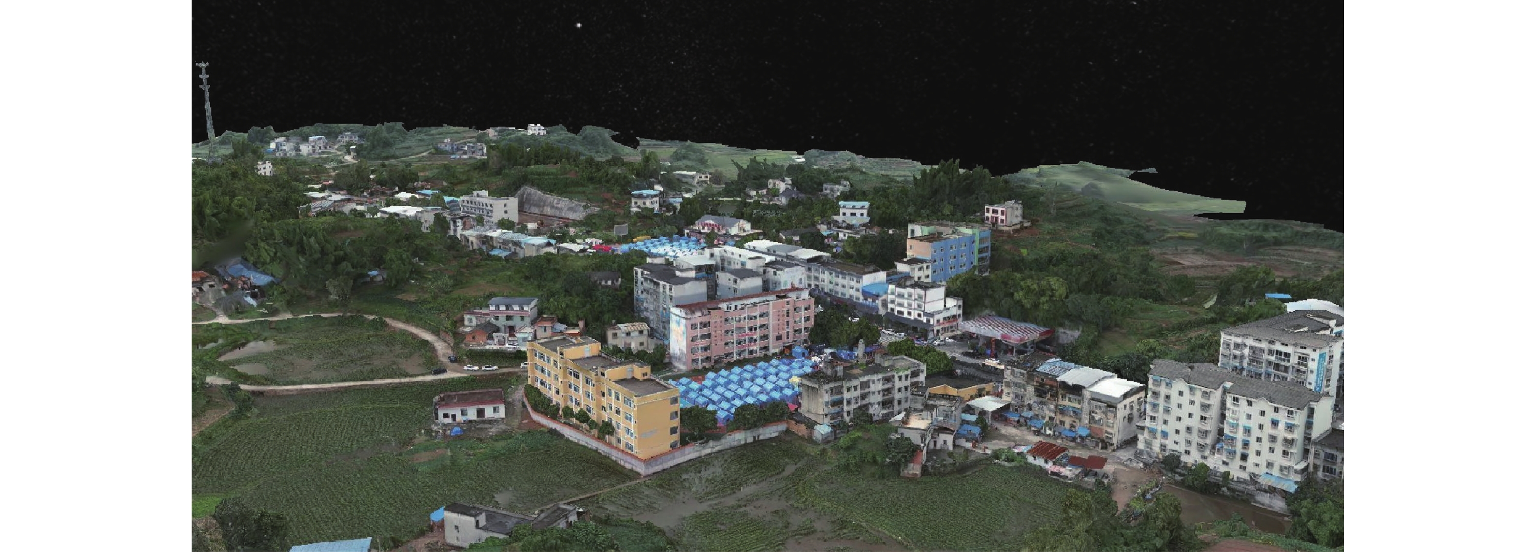
图 3 福集镇大田社区震后三维模型
Figure 3. Three-dimensional model of Datian community in Fuji town after earthquake
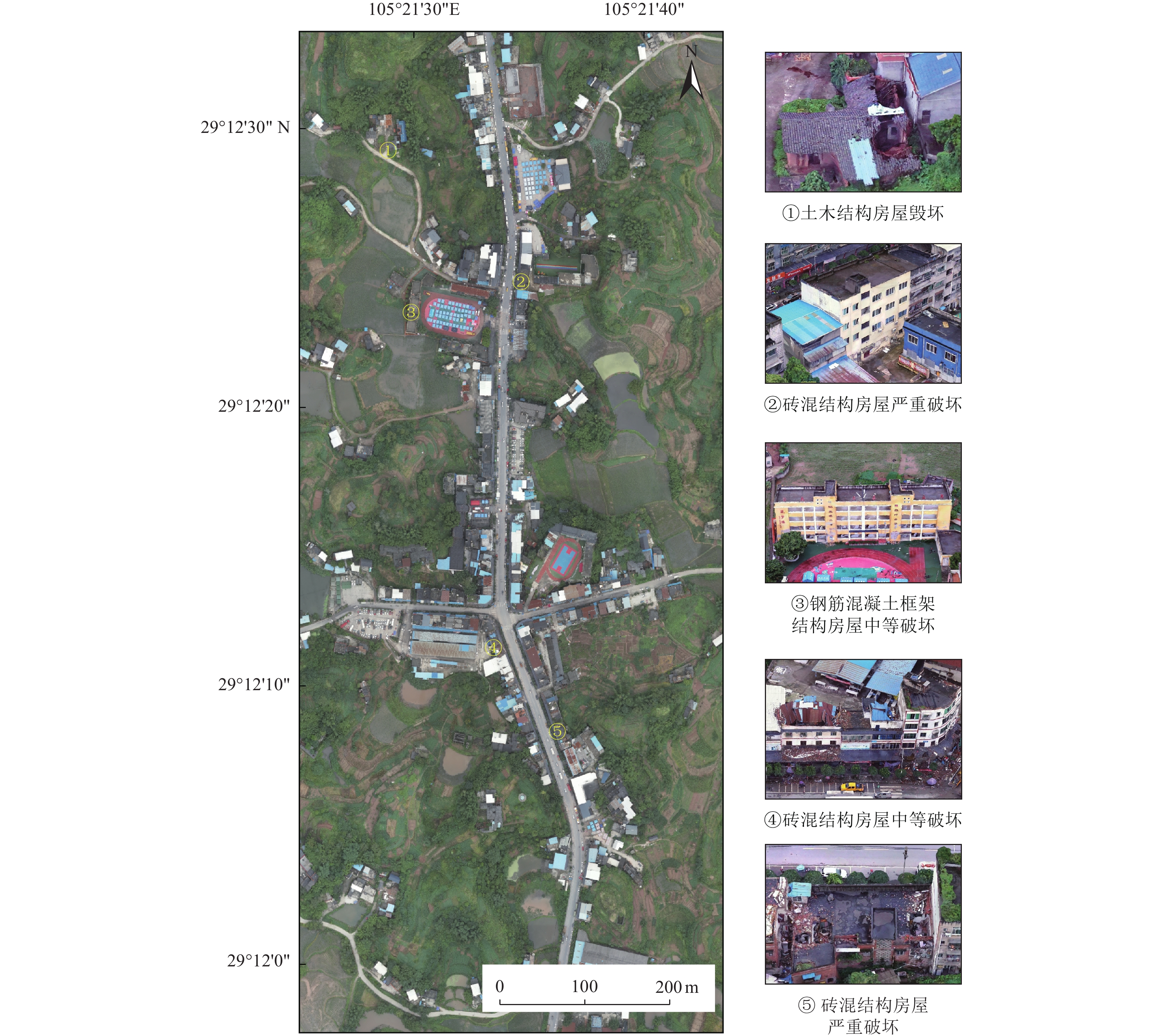
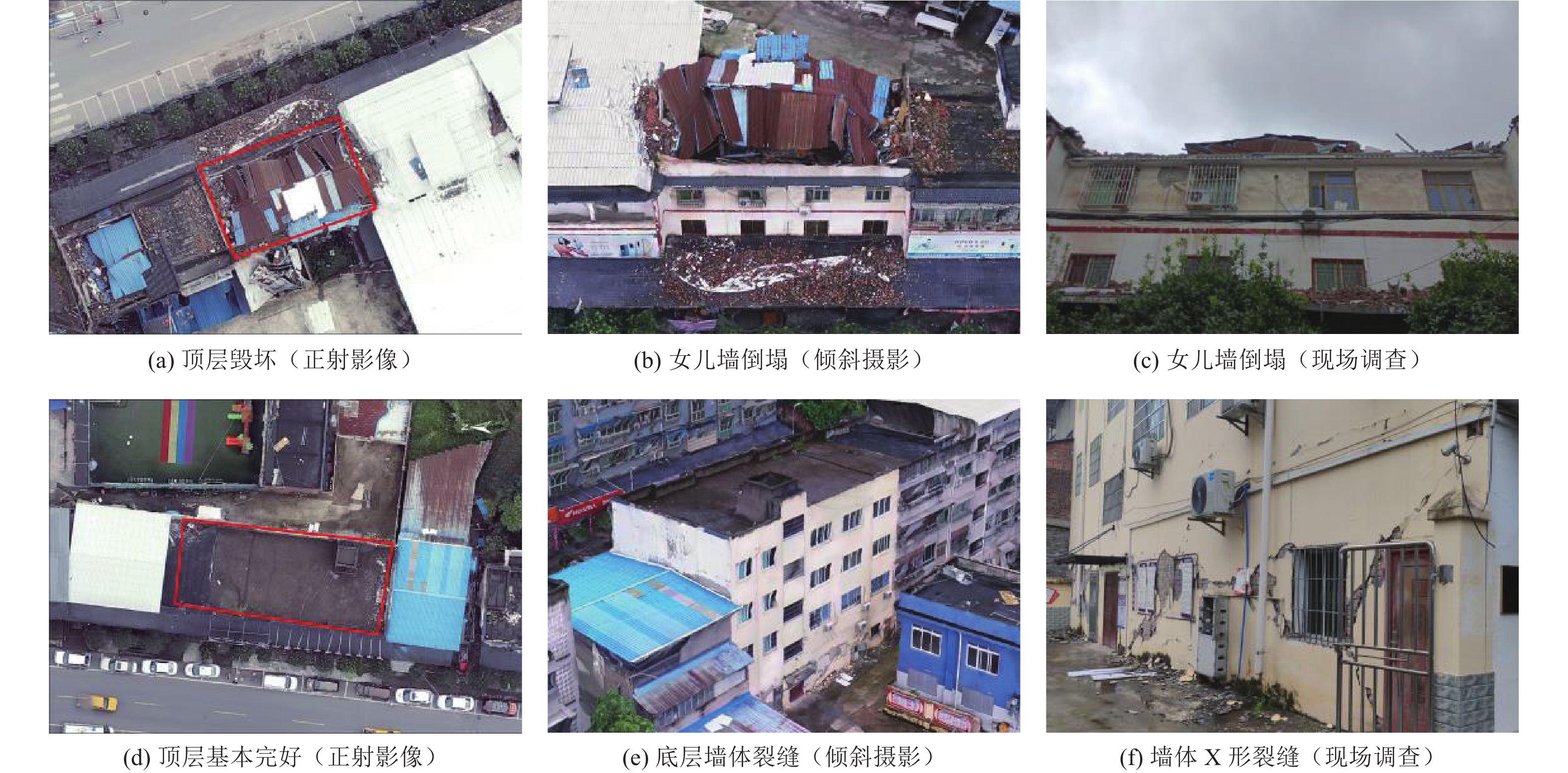
图 4 福集镇大田社区典型建筑物震害提取
Figure 4. Seismic damage extraction of typical buildings in Datian community of Fuji town
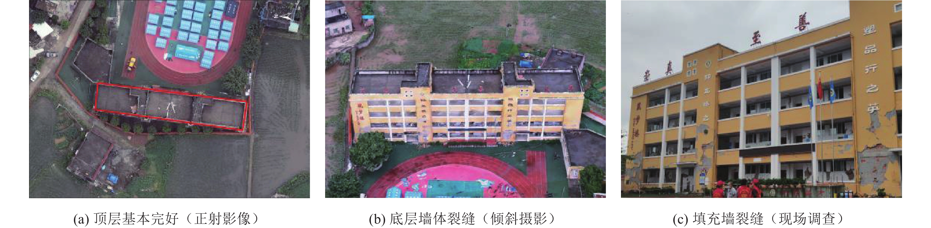
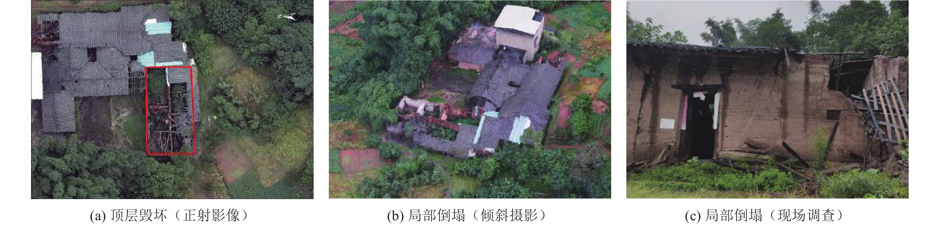
图 5 典型钢筋混凝土框架结构房屋震害
Figure 5. Typical seismic damage of reinforced concrete frame structure building

图 8 福集镇草坝村典型人员伤亡周边环境
Figure 8. Surrounding environment of typical casualties in Caoba village, Fuji town
表 1 无人机系统性能参数
Table 1. Specifications of UAV system
无人机平台性能名称 M300 RTK技术参数 质量/kg 6.3(含2块电池) 最大载重/kg 2.7 最大飞行海拔高度/m 5000(2110桨叶,起飞质量≤7 kg) 悬停精度/m 垂直精度:±0.1;水平精度:±0.1(RTK定位正常工作时) 最大旋转角速度/(°·s−1) 俯仰轴:300;航向轴:100 最大上升速度/(m·s−1) S模式:6;P模式:5 最大下降速度/(m·s−1) S模式:5;P模式:4 最大可承受风速/(m·s−1) 15(7级风) 防护等级 IP45  下载: 导出CSV
表 2 无人机倾斜摄影系统性能参数
Table 2. Specifications of UAV photography system
无人机荷载性能名称 MS Smart2技术参数 禅思P1技术参数 质量/g 580 约800 镜头数量/个 5 1 传感器尺寸/mm 22.3×14.9 35.9×24.0 照片尺寸/Pix 6 000×4 000 8 192×5 460 最小拍照间隔/s 0.2 0.7 有效像素 2 430万(总像素>1.2亿) 4 500万 防护等级 IP54 IP4 X 搭载续航 /min 约45 约45
下载: 导出CSV
-
国家市场监督管理总局, 中国国家标准化管理委员会, 2020. GB/T 17742—2020 中国地震烈度表. 北京: 中国标准出版社.State Administration for Market Regulation, Inspection and Quarantine of the People's Republic of China, Standards Administration of China, 2020. GB/T 17742—2020 The Chinese seismic intensity scale. Beijing: Standards Press of China. (in Chinese) 荆帅军, 帅向华, 甄盟, 2019. 基于无人机倾斜影像的三维建筑物震害精细信息提取. 地震学报, 41(3): 366—376Jing S. J. , Shuai X. H. , Zhen M. , 2019. Fine information extraction of 3 D building seismic damage based on unmanned aerial vehicle oblique images. Acta Seismologica Sinica, 41(3): 366—376. (in Chinese) 李玮玮, 帅向华, 刘钦, 2016. 基于倾斜摄影三维影像的建筑物震害特征分析. 自然灾害学报, 25(2): 152—158 doi: 10.13577/j.jnd.2016.0218Li W. W. , Shuai X. H. , Liu Q. , 2016. Building damage characteristics analysis based on the three-dimensional image from oblique photography. Journal of Natural Disasters, 25(2): 152—158. (in Chinese) doi: 10.13577/j.jnd.2016.0218 帅向华, 聂高众, 姜立新等, 2011. 国家地震灾情调查系统探讨. 震灾防御技术, 6(4): 396—405 doi: 10.3969/j.issn.1673-5722.2011.04.005Shuai X. H. , Nie G. Z. , Jiang L. X. , et al. , 2011. The study of national earthquake disaster investigation system. Technology for Earthquake Disaster Prevention, 6(4): 396—405. (in Chinese) doi: 10.3969/j.issn.1673-5722.2011.04.005 帅向华, 刘钦, 甄盟等, 2018. 倾斜摄影技术在云南鲁甸地震现场的应用研究. 震灾防御技术, 13(1): 158—167 doi: 10.11899/zzfy20180114Shuai X. H. , Liu Q. , Zhen M. , et al. , 2018. Application of the UVA oblique photography technique in the field of Ludian earthquake, Yunnan. Technology for Earthquake Disaster Prevention, 13(1): 158—167. (in Chinese) doi: 10.11899/zzfy20180114 肖本夫, 申源, 陈维锋等, 2020. 基于MINA框架的应急救助与地震灾情管理平台设计与实现. 震灾防御技术, 15(4): 836—845 doi: 10.11899/zzfy20200418Xiao B. F. , Shen Y. , Chen W. F. , et al. , 2020. Design and implementation of management platform of emergency assistance and seismic disaster based on the MINA framework. Technology for Earthquake Disaster Prevention, 15(4): 836—845. (in Chinese) doi: 10.11899/zzfy20200418 许建华, 张雪华, 王晓青等, 2017. 无人机倾斜摄影技术在地震烈度评估中的应用——以九寨沟7.0级地震为例. 中国地震, 33(4): 655—662 doi: 10.3969/j.issn.1001-4683.2017.04.021Xu J. H. , Zhang X. H. , Wang X. Q. , et al. , 2017. The application of oblique photography technology in seismic intensity assessment—Taking the Jiuzhaigou MS7.0 earthquake as an example. Earthquake Research in China, 33(4): 655—662. (in Chinese) doi: 10.3969/j.issn.1001-4683.2017.04.021 张方浩, 杜浩国, 张原硕等, 2021. 基于倾斜摄影的2021年云南漾濞MS6.4地震典型震害调查分析. 地震研究, 44(3): 481—489Zhang F. H. , Du H. G. , Zhang Y. S. , et al. , 2021. Investigation of typical earthquake-damage caused by the 2021 Yangbi, Yunnan MS6.4 earthquake based on the oblique photography. Journal of Seismological Research, 44(3): 481—489. (in Chinese) 张露露, 何雅枫, 宴金旭等, 2021. 基于无人机影像的漾濞地震房屋震害定量评估. 华南地震, 41(3): 76—81 doi: 10.13512/j.hndz.2021.03.11Zhang L. L. , He Y. F. , Yan J. X. , et al. , 2021. Quantitative assessment of building damage of the Yangbi earthquake based on UAV images. South China Journal of Seismology, 41(3): 76—81. (in Chinese) doi: 10.13512/j.hndz.2021.03.11 中华人民共和国国家质量监督检验检疫总局, 中国国家标准化管理委员会, 2012. GB/T 18208.3—2011地震现场工作 第3部分: 调查规范. 北京: 中国标准出版社.General Administration of Quality Supervision, Inspection and Quarantine of the People's Republic of China, Standards Administration of China, 2012. GB/T 18208.3—2011 Post-earthquake field works - Part 3: Code for field survey. Beijing: Standards Press of China. (in Chinese) Xu Z. , Wu Y. , Lu X. Z. , et al. , 2020. Photo-realistic visualization of seismic dynamic responses of urban building clusters based on oblique aerial photography. Advanced Engineering Informatics, 43: 101025. doi: 10.1016/j.aei.2019.101025 Zhang R. , Li H. , Duan K. F. , et al. , 2020. Automatic detection of earthquake-damaged buildings by integrating UAV oblique photography and infrared thermal imaging. Remote Sensing, 12(16): 2621. doi: 10.3390/rs12162621 -

 点击查看大图
计量
- 文章访问数: 244
- HTML全文浏览量: 109
- PDF下载量: 28
- 被引次数: 0
