
Preliminary Research on House Information Extraction Technology Based on UAV Images
-
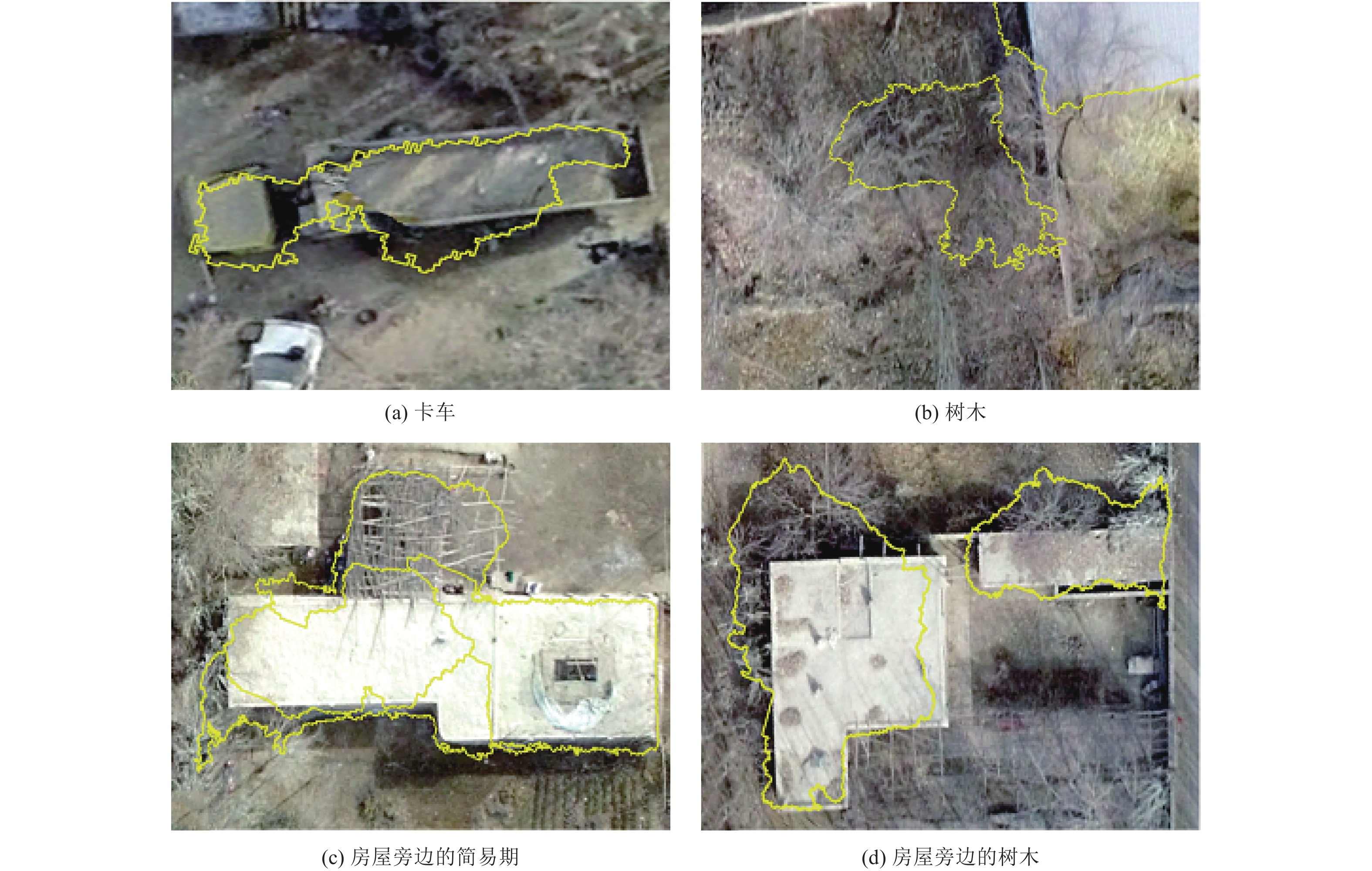
摘要: 本文以新疆疏附县境内的无人机影像为基础,采用多种方法对研究区内的房屋进行自动提取。由于不同地物在无人机影像中的色彩差异不显著,基于像元的房屋信息提取效果不理想;面向对象的房屋信息提取方法能够识别出绝大部分房屋,但基于DOM影像的提取结果难以识别房屋数量及单栋房屋的面积,而nDSM数据具有房屋的高度信息,基于nDSM数据提取的房屋信息相对较好,提取的房屋信息与实际结果较为吻合,造成误差的原因主要是简易棚和树木的干扰。结果表明,无人机影像具有明显优势,可为区域房屋调查提供有效的基础信息。Abstract: Based on UAV images in Shufu county, Xinjiang Province, a variety of methods were used to automatically extract houses in the study area. Because the color difference of different objects in the drone image is not significant, the selected classification method is not suitable and the pixel-based house information extraction effect is not ideal. Object-oriented house information extraction methods can identify most houses, but it is difficult to identify the number of houses and the area of a single house due to its base on DOM image extraction. With the elevation information of houses, the house information extracted based on nDSM data is the best. The extracted house information is more consistent with the actual one. The main error is caused by simple sheds and the interference of trees. The results show that UAV images have obvious advantages and can provide effective basic information for regional house surveys.
-
Key words:
- UAV image /
- Houses /
- Information extraction
-
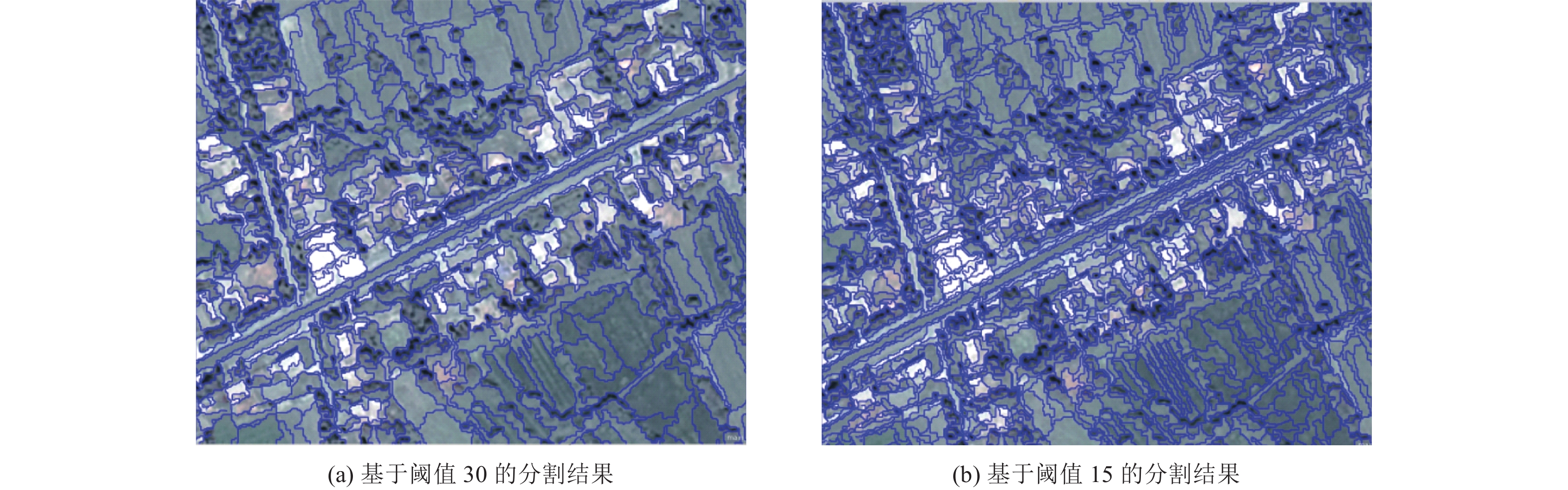
图 3 不同阈值分割结果对比图
Figure 3. Comparison of segmentation results with different thresholds
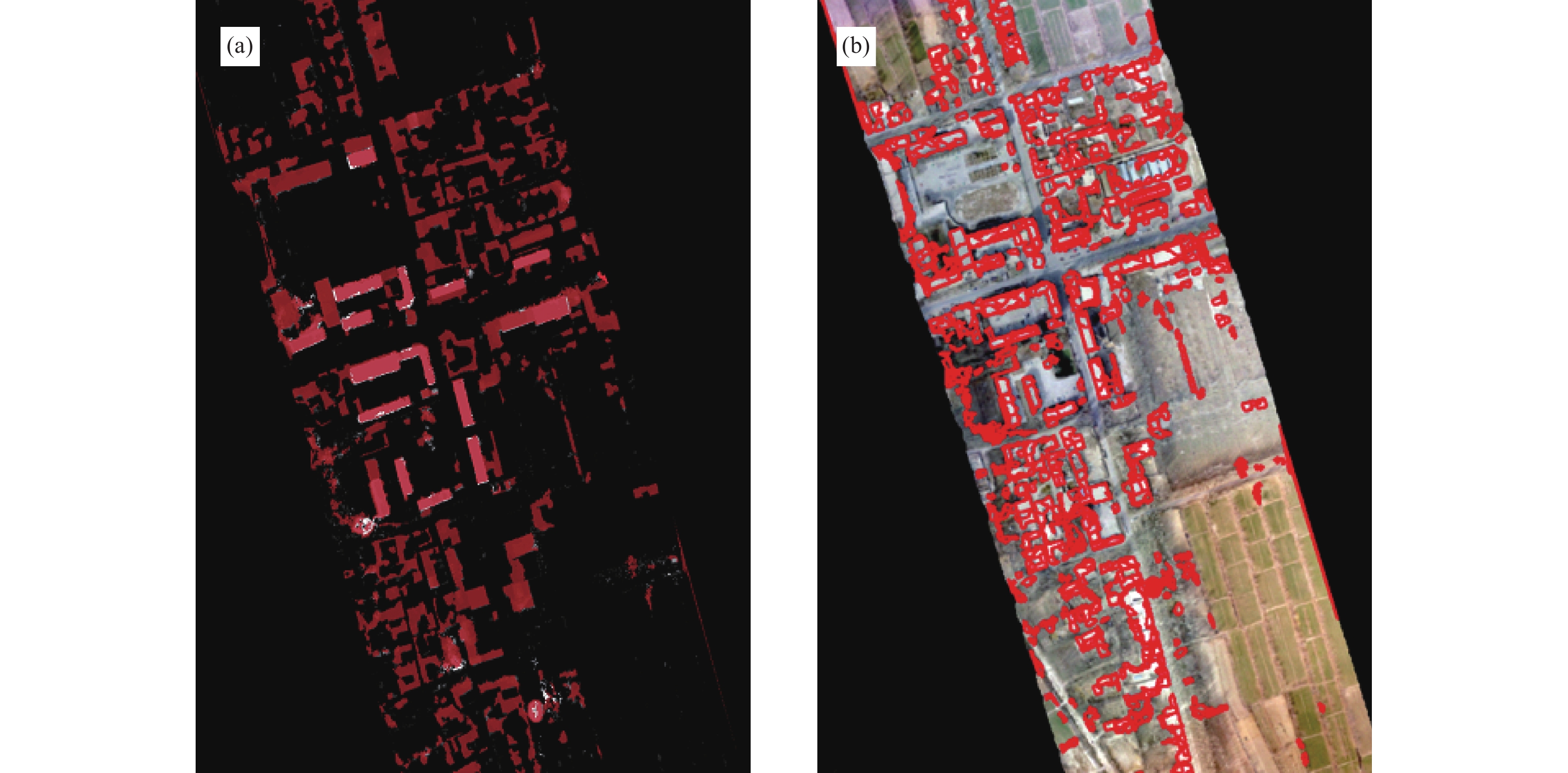
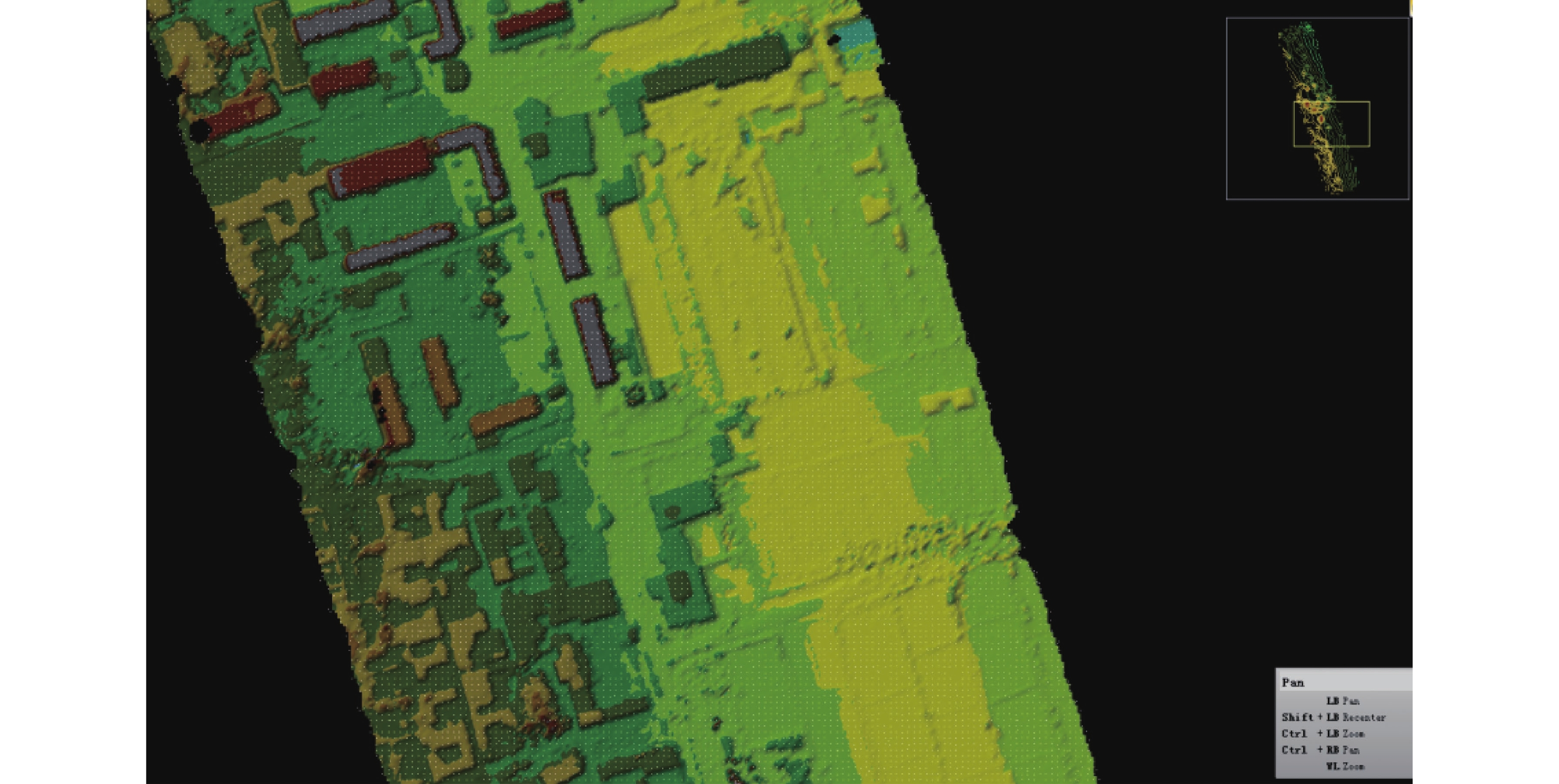
图 6 nDSM归一化数字表面模型及房屋信息提取结果
Figure 6. Normalized nDSM surface digital model and extracted house information
表 1 房屋提取精度评价
Table 1. Accuracy of evaluation of house extraction
评价区 Sm/m2 Sa/m2 Sc/m2 C/% 1 6045 6324 4616 73 2 5074 5135 4313 84 3 5112 5226 3919 75  下载: 导出CSV
-
杜凤兰, 田庆久, 夏学齐等, 2004. 面向对象的地物分类法分析与评价. 遥感技术与应用, 19(1): 20—23 doi: 10.3969/j.issn.1004-0323.2004.01.005Du F. L. , Tian Q. J. , Xia X. Q. , et al. , 2004. Object-oriented image classification analysis and evaluation. Remote Sensing Technology and Application, 19(1): 20—23. (in Chinese) doi: 10.3969/j.issn.1004-0323.2004.01.005 付博, 2018. 基于无人机正射影像的建筑物震害识别研究. 北京: 中国地震局地质研究所.Fu B., 2018. Recognition of Earthquake-caused buildings damage based on UAV orthophoto. Beijing: Institute of Geology, China Earthquake Administration. (in Chinese) 付伟锋, 邹维宝, 2018. 深度学习在遥感影像分类中的研究进展. 计算机应用研究, 35(12): 3521—3525 doi: 10.3969/j.issn.1001-3695.2018.12.001Fu W. F. , Zou W. B. , 2018. Review of remote sensing image classification based on deep learning. Application Research of Computers, 35(12): 3521—3525. (in Chinese) doi: 10.3969/j.issn.1001-3695.2018.12.001 和仕芳, 邓树荣, 张方浩等, 2016. 旋翼无人机在建筑物抗震能力调查中的应用. 地震研究, 39(4): 673—679 doi: 10.3969/j.issn.1000-0666.2016.04.018He S. F. , Deng S. R. , Zhang F. H. , et al. , 2016. Application of the rotor UAV in the seismic-capacity survey of the buildings. Journal of Seismological Research, 39(4): 673—679. (in Chinese) doi: 10.3969/j.issn.1000-0666.2016.04.018 金永涛, 杨秀峰, 高涛等, 2018. 基于面向对象与深度学习的典型地物提取. 国土资源遥感, 30(1): 22—29Jin Y. T. , Yang X. F. , Gao T. , et al. , 2018. The typical object extraction method based on object-oriented and deep learning. Remote Sensing for Land & Resources, 30(1): 22—29. (in Chinese) 荆帅军, 2019. 基于无人机倾斜影像的建筑物震害提取研究. 北京: 中国地震局地震预测研究所.Jing S. J., 2019. Research on building earthquake damage extraction based on UAV oblique images. Beijing: Institute of Earthquake Science, China Earthquake Administration. (in Chinese) 李金香, 李亚芳, 李帅等, 2017. 无人机遥感技术在新疆皮山地震灾情获取中的应用. 震灾防御技术, 12(3): 690—699 doi: 10.11899/zzfy20170324Li J. X. , Li Y. F. , Li S. , et al. , 2017. Application of remote sensing technology of UAV in the acquisition of earthquake disaster in Pishan, Xinjiang. Technology for Earthquake Disaster Prevention, 12(3): 690—699. (in Chinese) doi: 10.11899/zzfy20170324 李金香, 赵朔, 金花等, 2019. 结合纹理和形态学特征的高分遥感影像建筑物震害信息提取. 地震学报, 41(5): 658—670 doi: 10.11939/jass.20190014Li J. X. , Zhao S. , Jin H. , et al. , 2019. A method of combined texture features and morphology for building seismic damage information extraction based on GF remote sensing images. Acta Seismologica Sinica, 41(5): 658—670. (in Chinese) doi: 10.11939/jass.20190014 李鹏飞, 2015. 基于无人机影像建筑物提取技术的研究. 南昌: 东华理工大学.Li P. F., 2015. Study on the technology of building extraction based on UAV aerial image. Nanchang: East China University of Technology. (in Chinese) 王晓青, 魏成阶, 苗崇刚等, 2003. 震害遥感快速提取研究——以2003年2月24日巴楚-伽师6.8级地震为例. 地学前缘, 10(特刊): 285—291Wang X. Q. , Wei C. J. , Miao C. G. , et al. , 2003. The extraction of seismic damage from remote sensing images——A case study of Bachu-Jiashi earthquake with MS=6.8 occurred on Feb. 24, 2003. Earth Science Frontiers, 10(S): 285—291. (in Chinese) 王晓青, 王龙, 王岩等, 2008. 汶川8.0级大地震应急遥感震害评估研究. 震灾防御技术, 3(3): 251—258 doi: 10.3969/j.issn.1673-5722.2008.03.007Wang X. Q. , Wang L. , Wang Y. , et al. , 2008. Study on the damage assessment of Wenchuan Ms8.0 earthquake based on remote sensing imagery. Technology for Earthquake Disaster Prevention, 3(3): 251—258. (in Chinese) doi: 10.3969/j.issn.1673-5722.2008.03.007 熊增连, 潘建平, 阳春花, 2015. 面向对象的房屋特征信息自动提取方法. 地理空间信息, 13(5): 16—18. doi: 10.3969/j.issn.1672-4623.2015.05.006 曾龙文, 2017. 基于无人机遥感影像建筑物提取系统设计与实现. 雅安: 四川农业大学.Zeng L. W., 2017. Design and implementation of building extraction system for remote sensing image based on unmanned aerial vehicle. Yaan: Sichuan Agricultural University. (in Chinese) 张磊, 张景发, 2009. 基于面向对象分类的建筑物倒塌率计算方法研究. 地震, 29(增刊): 139—145Zhang L. , Zhang J. F. , 2009. Research on the ratio of collapsed buildings based on object-oriented classification. Earthquake, 29(S): 139—145. (in Chinese) 赵妍, 张景发, 姚磊华, 2016. 基于面向对象的高分辨率遥感建筑物震害信息提取与评估. 地震学报, 38(6): 942—951 doi: 10.11939/jass.2016.06.014Zhao Y. , Zhang J. F. , Yao L. H. , 2016. Seismic damage information extraction and evaluation of buildings with high resolution remote sensing based on object—oriented method. Acta Seismologica Sinica, 38(6): 942—951. (in Chinese) doi: 10.11939/jass.2016.06.014 -


 点击查看大图
图(8) / 表(1)
计量
- 文章访问数: 186
- HTML全文浏览量: 119
- PDF下载量: 31
- 被引次数: 0
