
UAV Remote Sensing Information Acquisition and Analysis of MS5.4 Earthquake in Baicheng County, Xinjiang
-
摘要: 以2021年3月24日新疆维吾尔自治区阿克苏地区拜城县MS5.4地震为例,利用无人机进行灾区航拍,结合现场调查完成灾区地表破裂情况、建筑物毁坏程度、道路毁坏程度无人机遥感灾情获取与分析。研究结果表明,此次拜城地震产生长约5 km的地表破裂带,主破裂带具有左旋走滑特征,与主压应力场方向一致;受地震动、地表破裂、场地类型及土壤成分等因素影响,地表破裂带周边老旧砖木结构房屋不同程度受损,乡村道路不同程度破坏;此次地震造成的地表破裂和震害分布情况受断裂带控制。Abstract: Taking the MS5.4 earthquake in Baicheng County, Aksu District, Xinjiang Uygur Autonomous Region on March 24, 2021 as an example, this study uses UAV to take aerial photos of the disaster area, and completes UAV remote sensing information acquisition and analysis of the surface rupture, building damage and road damage in the disaster area combined with field investigation. The results show that the Baicheng earthquake causes a surface rupture zone with a length of about 5 km, the main rupture zone has the characteristics of sinistral strike slip, which is consistent with the direction of the main compressive stress field; Affected by ground motion, surface rupture, site type, soil composition and other factors, the old brick and wood structure houses around the surface rupture zone are damaged to varying degree, and the rural roads are damaged to varying degree. The distribution of surface rupture and earthquake damage caused by the Baicheng earthquake is controlled by the fault zone.
-
Key words:
- Earthquake /
- Remote sensing image /
- UAV /
- Disaster acquisition
-
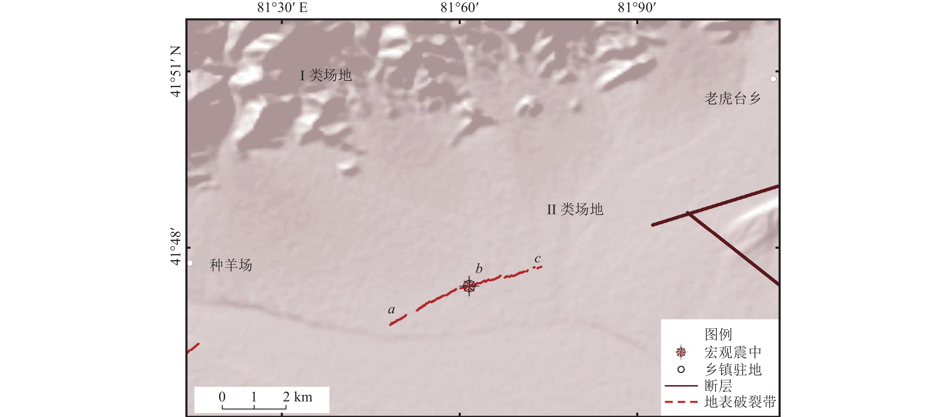
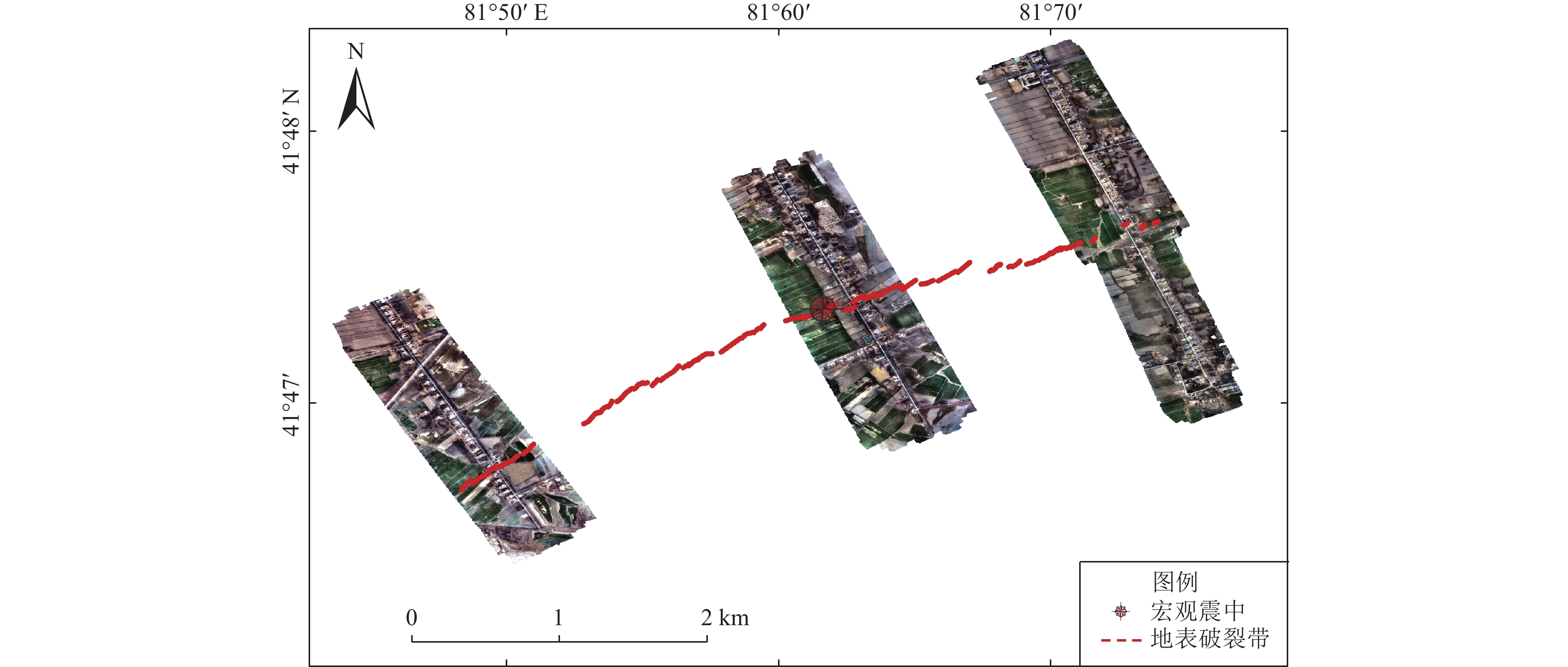
图 4 地表破裂带的空间分布和分段特征
Figure 4. Spatial distribution and segmentation characteristics of surface rupture zone
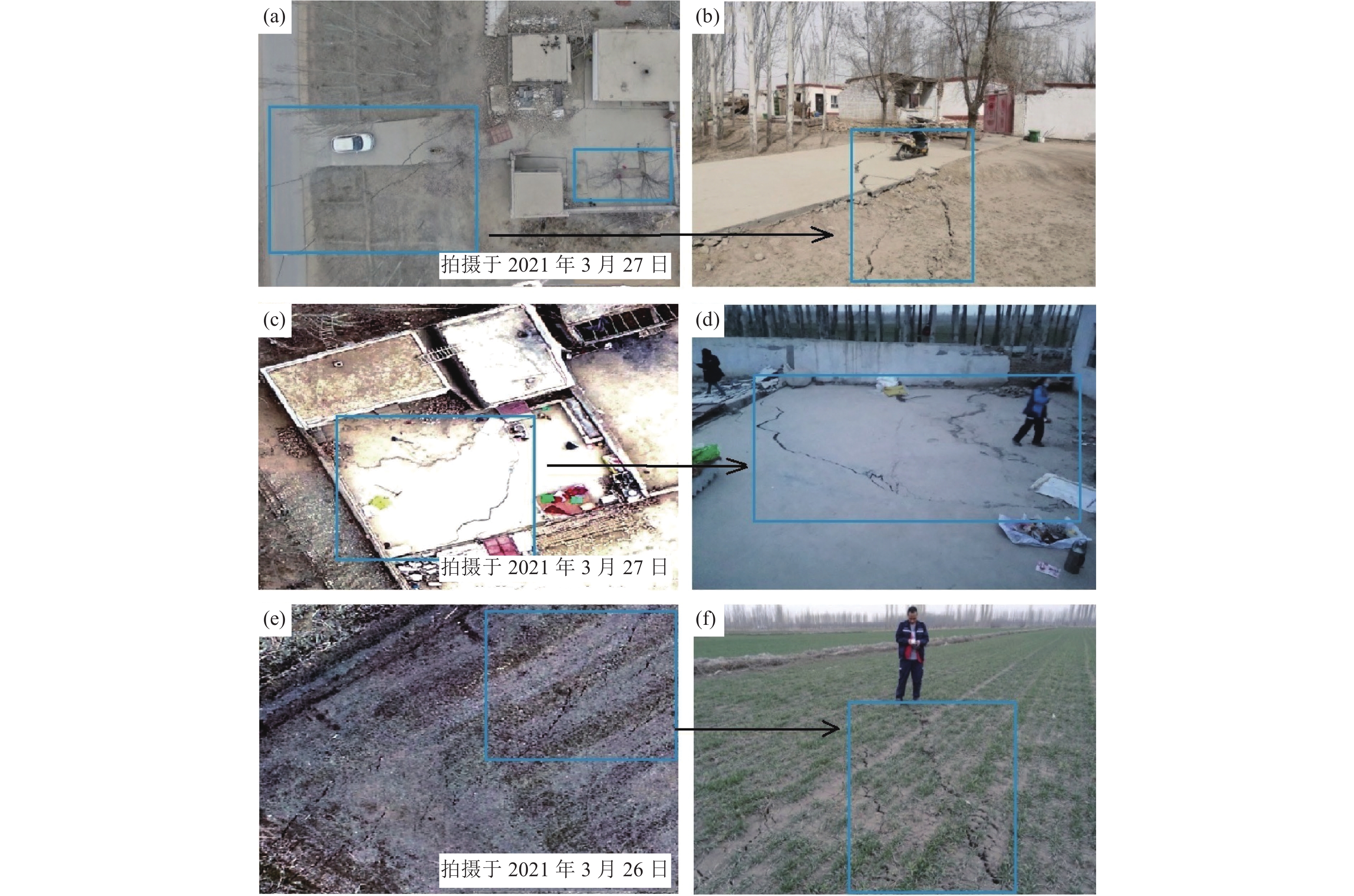
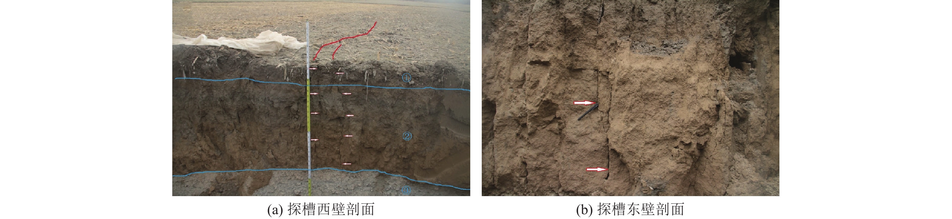
图 6 地表破裂带无人机影像与现场调查对比
Figure 6. Comparison between UAV image and field investigation in surface rupture zone
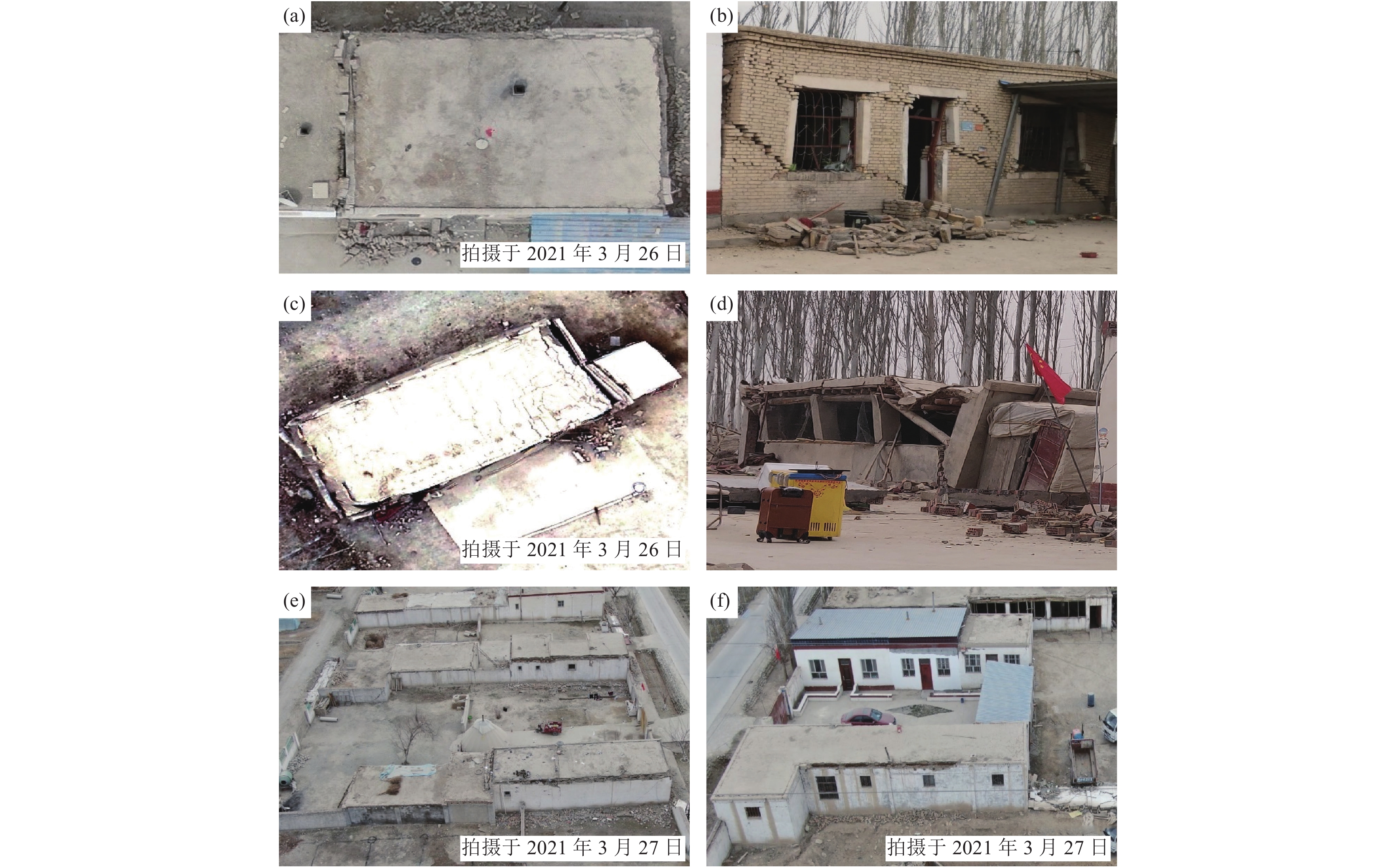
图 7 房屋建筑无人机影像与现场调查对比
Figure 7. Comparison between UAV image of house building and field investigation
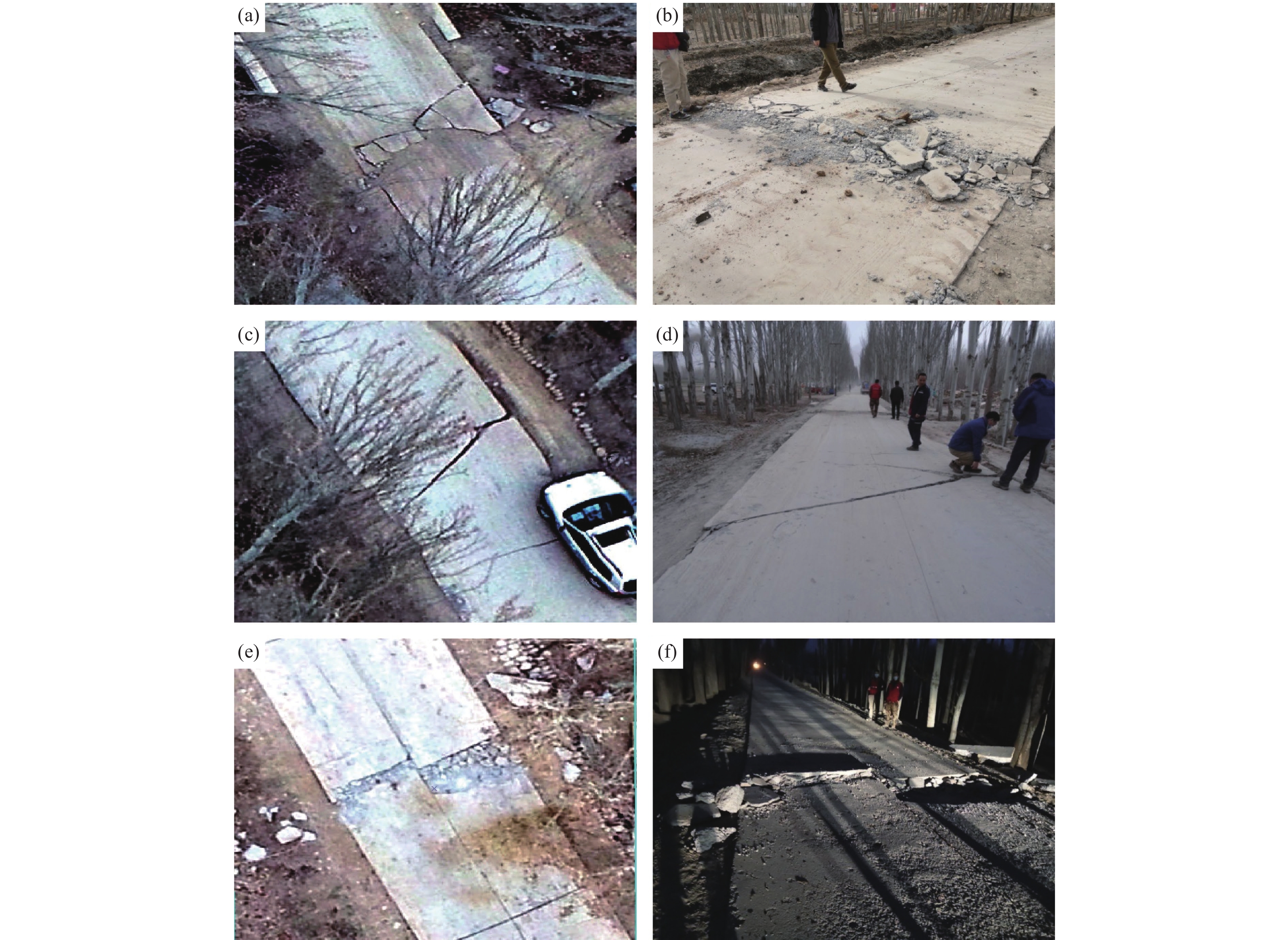
图 9 交通系统无人机影像与现场调查对比
Figure 9. Comparison between UAV image of traffic system and field investigation
表 1 拜城MS5.4地震震源机制解参数
Table 1. Focal mechanism solution parameters of the Baicheng MS5.4 earthquake
节面Ⅰ/° 节面Ⅱ/° 震级/MW 深度/km 产出机构 震源机制解 走向 倾向 滑动角 走向 倾向 滑动角 341 75 180 71 90 15 5.2 12 CENC 
160 82 55 253 65 9 — — CEA-IGP 
340.41 84.77 −176.43 250.08 86.44 −5.24 — — 万永革研究员课题组 
160 77 167 253 77 12 5.2 13 GFZ 
 下载: 导出CSV
-
陈顺云, 马瑾, 刘培洵等, 2014. 利用卫星遥感热场信息探索现今构造活动: 以汶川地震为例. 地震地质, 36(3): 775—793Chen S. Y. , Ma J. , Liu P. X. , et al. , 2014. Exploring the current tectonic activity with satellite remote sensing thermal information: a case of the Wenchuan earthquake. Seismology and Geology, 36(3): 775—793. (in Chinese) 邓飞, 窦爱霞, 吴玮莹等, 2018. 基于无人机遥感的四川九寨沟地震极灾区灾情快速调查. 灾害学, 33(3): 210—215Deng F. , Dou A. X. , Wu W. Y. , et al. , 2018. Rapid investigation of disaster situation in extreme disaster area of Jiuzhaigou earthquake in Sichuan based on UAV remote sensing. Journal of Catastrophology, 33(3): 210—215. (in Chinese) 董彦芳, 袁小祥, 王晓青等, 2012.2010年青海玉树MS7.1地震地表破裂特征的高分辨率遥感分析. 地震, 32(1): 82—92 doi: 10.3969/j.issn.1000-3274.2012.01.008Dong Y. F. , Yuan X. X. , Wang X. Q. , et al. , 2012. Analysis of surface ruptures caused by the 2010 MS7.1 Yushu, Qinghai earthquake using high resolution remote sensing images. Earthquake, 32(1): 82—92. (in Chinese) doi: 10.3969/j.issn.1000-3274.2012.01.008 杜浩国, 林旭川, 张建国等, 2021. 基于改进蚁群算法与无人机影像的震害识别方法及其在漾濞地震中的应用. 地震地质, 43(4): 1013—1029Du H. G. , Lin X. C. , Zhang J. G. , et al. , 2021. A seismic damage identification method based on improved ant colony algorithm and unmanned aerial vehicle images and its application to Yangbi earthquake. Seismology and Geology, 43(4): 1013—1029. (in Chinese) 付博, 李志强, 陈杰等, 2018. 微型无人机在2016年11月25日阿克陶Mw6.6地震中的应用探索. 地震地质, 40(3): 672—684Fu B. , Li Z. Q. , Chen J. , et al. , 2018. The application of miniature unmanned aerial vehicle in 25 November 2016 Arketao MW6.6 earthquake. Seismology and Geology, 40(3): 672—684. (in Chinese) 顾诗瑶, 王玲, 刘飞等, 2021. 基于无人机影像的长宁地震建筑物震害提取与成因分析. 灾害学, 36(1): 217—222 doi: 10.3969/j.issn.1000-811X.2021.01.040Gu S. Y. , Wang L. , Liu F. , et al. , 2021. UAV and GIS based structure damage assessment after Changning earthquake. Journal of Catastrophology, 36(1): 217—222. (in Chinese) doi: 10.3969/j.issn.1000-811X.2021.01.040 和仕芳, 邓树荣, 张方浩等, 2016. 旋翼无人机在建筑物抗震能力调查中的应用. 地震研究, 39(4): 673—679He S. F. , Deng S. R. , Zhang F. H. , et al. , 2016. Application of the rotor UAV in the seismic-capacity survey of the buildings. Journal of Seismological Research, 39(4): 673—679. (in Chinese) 荆帅军, 帅向华, 甄盟, 2019. 基于无人机倾斜影像的三维建筑物震害精细信息提取. 地震学报, 41(3): 366—376Jing S. J. , Shuai X. H. , Zhen M. , 2019. Fine information extraction of 3 D building seismic damage based on unmanned aerial vehicle oblique images. Acta Seismologica Sinica, 41(3): 366—376. (in Chinese) 李玮玮, 帅向华, 刘钦, 2016. 基于倾斜摄影三维影像的建筑物震害特征分析. 自然灾害学报, 25(2): 152—158Li W. W. , Shuai X. H. , Liu Q. , 2016. Building damage characteristics analysis based on the three-dimensional image from oblique photography. Journal of Natural Disasters, 25(2): 152—158 (in Chinese) 蔺建强, 甘淑, 袁希平等, 2021. 免像控大疆精灵4 RTK无人机在数字校园测图中的应用. 城市勘测, (1): 84—87, 93Lin J. Q. , Gan S. , Yuan X. P. , et al. , 2021. Application of Image-free DJI Spirit 4 RTK UAV in digital campus mapping. Urban Geotechnical Investigation & Surveying, (1): 84—87, 93. (in Chinese) 卢善龙, 沈晓华, 邹乐君等, 2008. 基于尺度分析的断层热信息遥感图像增强方法——以江山—绍兴断裂金衢段为例. 地球物理学报, 51(5): 1484—1493 doi: 10.3321/j.issn:0001-5733.2008.05.022Lu S. L. , Shen X. H. , Zou L. J. , et al. , 2008. Remote sensing image enhancement method of the fault thermal information based on scale analysis: a case study of Jiangshan-Shaoxing fault between Jinhua and Quzhou of Zhejiang Province, China. Chinese Journal of Geophysics, 51(5): 1484—1493. (in Chinese) doi: 10.3321/j.issn:0001-5733.2008.05.022 沈军, 吴传勇, 李军等, 2006. 库车坳陷活动构造的基本特征. 地震地质, 28(2): 269—278Shen J. , Wu C. Y. , Li J. , et al. , 2006. The basic features of the active tectonics in the Kuqa depression of the southern Tianshan. Seismology and Geology, 28(2): 269—278. (in Chinese) 童立强, 2008. “5•12”汶川大地震极重灾区地震堰塞湖应急遥感调查. 国土资源遥感, 20(3): 61—63Tong L. Q. , 2008. Emergency remote sensing investigation of Barrier Lakes at the quake center area caused by "5•12" Wenchuan strong earthquake. Remote Sensing for Land & Resources, 20(3): 61—63. (in Chinese) 王晓青, 黄树松, 丁香等, 2015. 尼泊尔8.1级地震建筑物震害遥感提取与分析. 震灾防御技术, 10(3): 481—490 doi: 10.11899/zzfy20150301Wang X. Q. , Huang S. S. , Ding X. , et al. , 2015. Extraction and analysis of building damage caused by Nepal MS8.1 earthquake from remote sensing images. Technology for Earthquake Disaster Prevention, 10(3): 481—490. (in Chinese) doi: 10.11899/zzfy20150301 吴玮, 秦其明, 范一大, 2015. 基于无人机可见光遥感影像的救灾帐篷信息提取. 地理与地理信息科学, 31(2): 20—23Wu W. , Qin Q. M. , Fan Y. D. , 2015. Information extraction of disaster relief tents in UAV visible light remotely sensed image. Geography and Geo-Information Science, 31(2): 20—23. (in Chinese) 解孟雨, 马亚伟, 张小涛等, 2021.2021年3月24日新疆拜城MS5.4地震总结. 地震地磁观测与研究, 42(3): 250—263Xie M. Y. , Ma Y. W. , Zhang X. T. , et al. , 2021. Summary of Baicheng MS5.4 earthquake in Xinjiang on March 26, 2021. Seismological and Geomagnetic Observation and Research, 42(3): 250—263. (in Chinese) 徐岳仁, 申旭辉, 洪顺英等, 2009. 用多源遥感数据解译深圳市主要活断层. 地震, 29(S1): 154—163Xu Y. R. , Shen X. H. , Hong S. Y. , et al. , 2009. Identification of major active faults in Shenzhen using multi-style remote sensing data. Earthquake, 29(S1): 154—163. (in Chinese) 徐志强, 杨建思, 姜旭东等, 2009. 无人机快速获取地震灾情的应用探索. 地震地磁观测与研究, 30(5): 66—70Xu Z. Q. , Yang J. S. , Jiang X. D. , et al. , 2009. To explore the application of pilotless aircraft in celerity investigation of earthquake disaster. Seismological and Geomagnetic Observation and Research, 30(5): 66—70. (in Chinese) 尹鹏飞, 尹球, 陈兴峰等, 2010. 无人机航空遥感技术在震后灾情调查中的应用. 激光与光电子学进展, 47(11): 112802Yin P. F. , Yin Q. , Chen X. F. , et al. , 2010. Unmanned aerial vehicle aerial remote sensing techniques and its application on post-earthquake disaster investigation. Laser & Optoelectronics Progress, 47(11): 112802. (in Chinese) 于江, 张彦琪, 李西等, 2018. 无人机航测技术在2014年鲁甸Ms6.5地震震区活动构造调查中的应用. 地震研究, 41(2): 166—172 doi: 10.3969/j.issn.1000-0666.2018.02.002Yu J. , Zhang Y. Q. , Li X. , et al. , 2018. Application of UAV aerial survey technology in survey of active tectonics in seismic area of the 2014 Ludian MS6.5 earthquake. Journal of Seismological Research, 41(2): 166—172. (in Chinese) doi: 10.3969/j.issn.1000-0666.2018.02.002 袁小祥, 王晓青, 丁香等, 2017. 基于无人机影像的九寨沟地震建筑物震害定量评估. 中国地震, 33(4): 582—589Yuan X. X. , Wang X. Q. , Ding X. , et al. , 2017. Quantitative assessment of building damage in disaster area of the Jiuzhaigou earthquake based on UAV images. Earthquake Research in China, 33(4): 582—589. (in Chinese) 张景发, 王四龙, 侯孝强, 1996. 活动断裂带中遥感数字图像处理技术——以鲜水河活动断裂带为例. 地震地质, 18(1): 1—16Zhang J. F. , Wang S. L. , Hou X. Q. , 1996. The technique of TM data image processing in the investigation of active fault zone──Xianshuihe active fault zone as an example. Seismology and Geology, 18(1): 1—16. (in Chinese) 张雪华, 王晓青, 杜晓霞等, 2019. 基于无人机遥感影像及其点云特征的建筑物震害提取. 地震研究, 42(2): 230—235Zhang X. H. , Wang X. Q. , Du X. X. , et al. , 2019. Extraction of buildings’ seismic damage based on remote sensing images of UAV and its point clouds characteristic. Journal of Seismological Research, 42(2): 230—235. (in Chinese) Ganas A. , Papadopoulos G. , Pavlides S. B. , 2001. The 7 September 1999 Athens 5.9 MS earthquake: remote sensing and digital elevation model inputs towards identifying the seismic fault. International Journal of Remote Sensing, 22(1): 191—196. doi: 10.1080/014311601750038938 Lin X. C. , Zhang H. Y. , Chen H. F. , et al. , 2015. Field investigation on severely damaged aseismic buildings in 2014 Ludian earthquake. Earthquake Engineering and Engineering Vibration, 14(1): 169—176. doi: 10.1007/s11803-015-0014-5 -


 点击查看大图

计量
- 文章访问数: 327
- HTML全文浏览量: 189
- PDF下载量: 41
- 被引次数: 0
