GNSS Monitoring of Cross Fault Seismic Deformation of China Myanmar Oil and Gas Pipeline Project
-
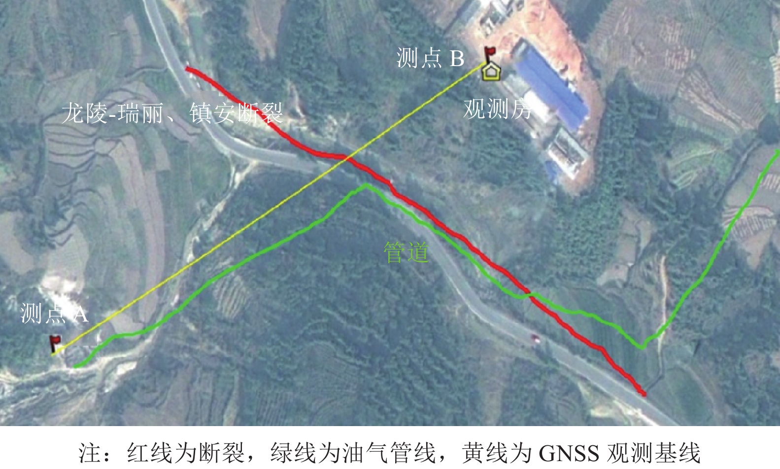
摘要: 中缅油气管道工程是我国重要的能源战略项目,该工程沿线地质背景复杂、破坏性地震多发,尤其是在云南境内跨越的3条大断裂曾发生过7级以上大震,有再次发生破坏性地震的可能性,对管道安全有潜在威胁。中缅油气管道地震观测项目通过在管道与3条断裂交汇处布设3组GNSS观测点,观测地震可能引起的断层位错,进而估计管道可能的变形影响。基于观测数据,分析影响观测的因素及断层位错的观测误差。管道变形承受能力对比结果表明,GNSS跨断裂变形观测系统能够有效观测断裂的位错,进而估计其对管道产生的影响。Abstract: China Myanmar natural gas pipeline project is an important energy strategic project in China, the geological background along the project is complex and destructive earthquakes are frequent, in particular, the three major faults across Yunnan have experienced major earthquakes of magnitude 7 or above, and it is likely to happen again which is a potential threat to the safety of the pipeline. The China Myanmar natural gas pipeline seismic monitoring project monitors the fracture dislocations that may be caused by earthquakes by setting up three groups of GNSS observation points at the intersection of the pipeline and three faults, so as to estimate the possible deformation impact of the pipeline. Based on the observation data, this paper discusses the factors affecting the observation, analyzes the observation error of fracture dislocation. Comparing the deformation bearing capacity of pipeline, it shows that the built GNSS cross fracture deformation observation system can effectively monitor the dislocation of fracture, and then estimate the possible impact of this deformation on pipeline.
-
表 1 GNSS测量系统技术性能指标
Table 1. Technical performance indexes of GNSS measurement system
指标 基本性能 通道 ≥24(并行) 测量方式 独立完整的码与载波相位测量、高精度的多重相关 L1/L2 伪距测量 采样 最大20 Hz RTK网络 VRS、FKP、MAC 数据存储 ≥32 MB 通信 RJ45、RS232,无线802.11 b 功耗 2 W 电源 10.5~28 V 直流,带压电保护功能。 工作温度 −30 ℃~70 ℃ 静态精度(MonNET 后处理) 水平:3 mm+0.5 ppm RMS
垂直:5 mm+1 ppm RMS快速静态基线精度(后处理)
水平:5 mm+0.5 ppm
垂直:10 mm+1 ppm动态定位:RTK
水平:10 mm+1 ppm
垂直:20 mm+1 ppm天线类型 L1/L2 零相位微对中天线,抑径板可以减少多路径干扰 天线增益 50 dB,内置低噪音放大器 使用温度 −40 ℃~70 ℃ 天线包装 防水、密封,高技术材料外壳机械强度高 表 2 数据利用率及周跳频次统计
Table 2. Statistics of data utilization and weekly hop frequency
测站 数据利用率/% 周跳频次 MDGCDS 100 0.006 2 MDGCF 100 0.012 0 MDGCDX 83 0.002 8 LLGCD 100 0.004 4 LLGCF 100 0.005 6 表 3 管道尺寸参数
Table 3. Design parameters of different pipeline projects
管道项目 外径/m 壁厚/m 设计压力/MPa 天然气管道 0.010 6 0.022 9 15 原油管道 0.813 0 0.028 6 15 成品油管道 0.219 1 0.009 5 15 表 4 管道容许变形计算
Table 4. Calculation of pipeline ultimate deformation
管道项目 容许拉伸量/cm 容许压缩量/cm 容许弯曲量/cm 天然气管道 41.13 27.57 8.4 原油管道 132.59 70.56 152.9 成品油管道 66.08 20.04 63.77 表 5 PPP基线误差收敛值
Table 5. Convergence value of PPP baseline error
方向 定西岭观测站基线
误差收敛值/cm龙陵观测站基线
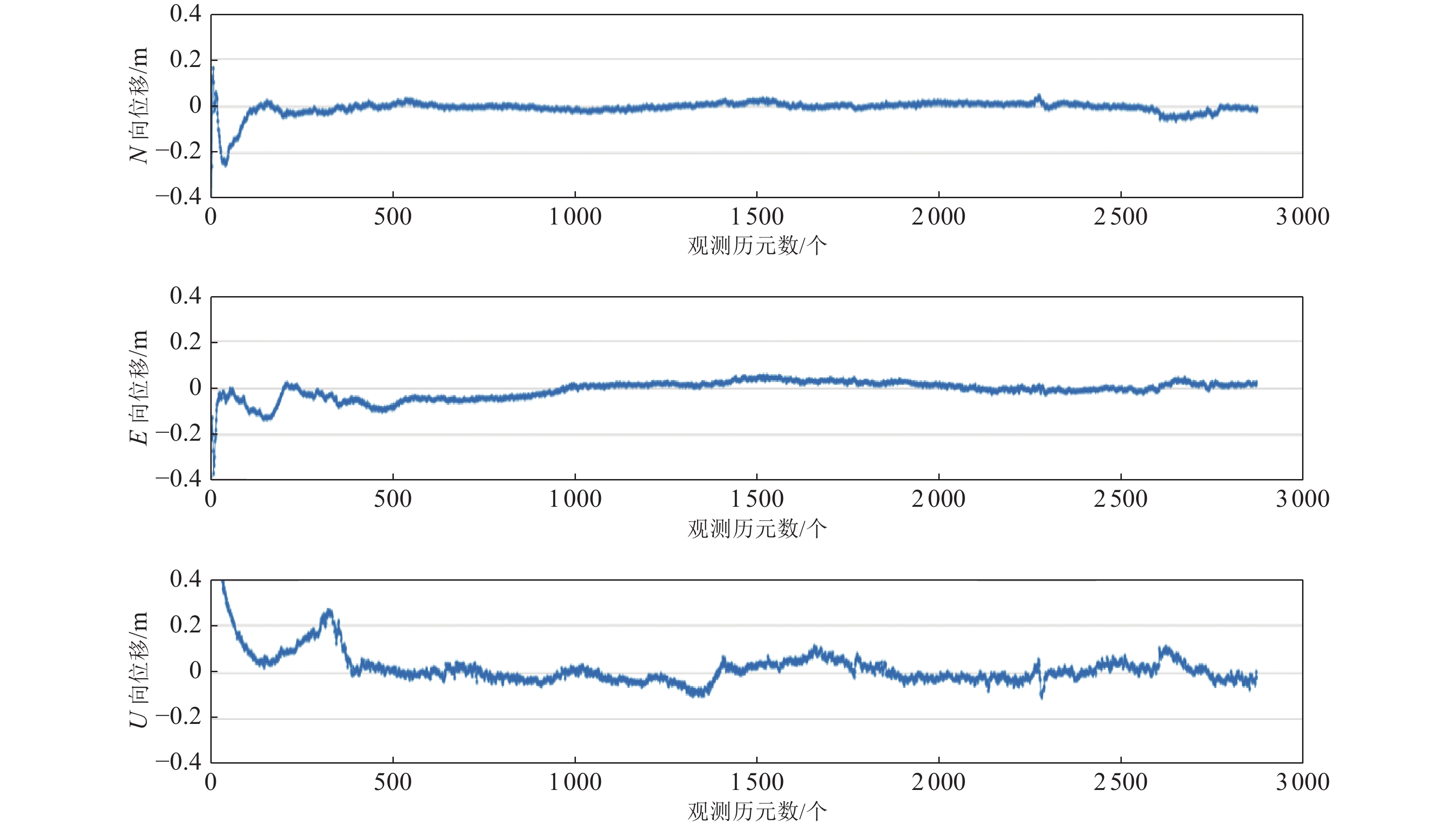
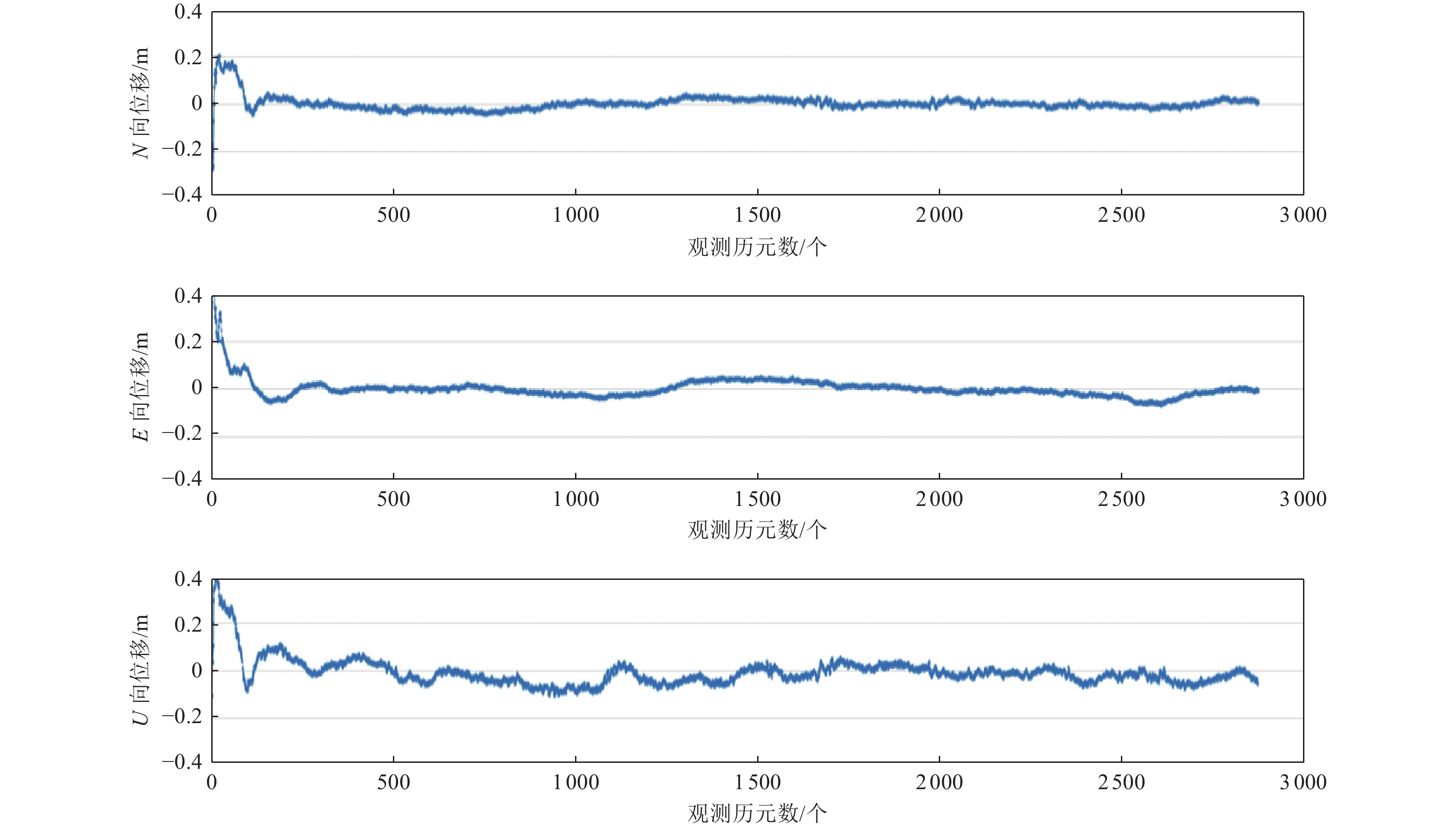
误差收敛值/cmN 0.514 0.412 E 0.381 0.379 U 3.341 4.314 表 6 不同观测站观测值与真实值差值的标准差
Table 6. Difference standard deviation between observed values and true values at different stations
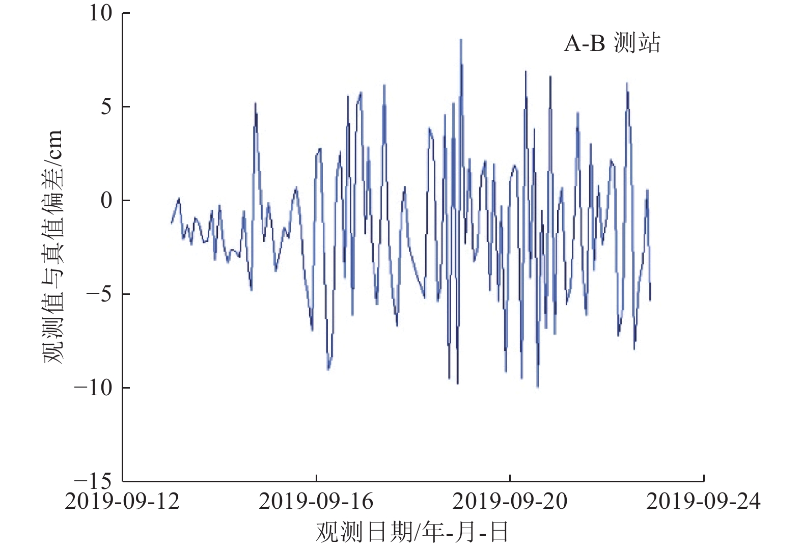
基线段 标准差/cm 定西岭观测站A-C 0.058 定西岭观测站B-C 0.060 定西岭观测站A-B 0.058 龙陵观测站A-B 0.029 表 7 N向GNSS管道观测阈值
Table 7. Observation threshold of GNSS pipeline in horizontal N direction
基线段 拉伸阈值/cm 压缩阈值/cm 弯曲阈值/cm 天然气管道 原油管道 成品油管道 天然气管道 原油管道 成品油管道 天然气管道 原油管道 成品油管道 定西岭观测站A-C 41.702 133.162 66.652 28.142 71.132 20.612 8.972 153.472 64.342 定西岭观测站B-C 41.704 133.164 66.654 28.144 71.134 20.614 8.974 153.474 64.344 定西岭观测站A-B 41.702 133.162 66.652 28.142 71.132 20.612 8.972 153.472 64.342 龙陵观测站A-B 41.571 133.031 66.521 28.011 71.001 20.481 8.943 153.443 64.313 表 8 E向GNSS管道观测阈值
Table 8. Observation threshold of GNSS pipeline in horizontal Edirection
基线段 拉伸阈值/cm 压缩阈值/cm 弯曲阈值/cm 天然气管道 原油管道 成品油管道 天然气管道 原油管道 成品油管道 天然气管道 原油管道 成品油管道 定西岭观测站A-C 41.569 133.029 66.519 28.007 70.999 20.479 8.839 153.339 64.209 定西岭观测站B-C 41.571 133.031 66.521 28.011 71.001 20.481 8.841 153.341 64.211 定西岭观测站A-B 41.569 133.029 66.519 28.009 70.999 20.479 8.839 153.339 64.209 龙陵观测站A-B 41.538 132.998 66.488 27.978 70.968 20.448 8.808 153.308 64.178 表 9 U向GNSS管道观测阈值
Table 9. Observation threshold of GNSS pipeline in vertical U direction
基线段 拉伸阈值/cm 压缩阈值/cm 弯曲阈值/cm 天然气管道 原油管道 成品油管道 天然气管道 原油管道 成品油管道 天然气管道 原油管道 成品油管道 定西岭观测站A-C 44.529 135.989 69.479 30.969 73.959 23.439 11.799 156.299 67.169 定西岭观测站B-C 44.531 135.991 69.481 30.971 73.961 23.441 11.801 156.301 67.171 定西岭观测站A-B 44.529 135.989 69.479 30.969 73.959 23.439 11.799 156.299 67.169 龙陵观测站A-B 45.473 136.933 70.423 31.913 73.93 24.383 12.743 157.243 68.113 -
布金伟, 左小清, 常军等, 2017. GNSS多星定位数据的质量分析. 昆明理工大学学报(自然科学版), 42(6): 24—36Bu J. W. , Zuo X. Q. , Chang J. , et al. , 2017. A quality analysis of GNSS satellite positioning data. Journal of Kunming University of Science and Technology (Natural Science Edition), 42(6): 24—36. (in Chinese) 陈秀德, 贾小林, 朱永兴等, 2018. 一种多GNSS的数据质量检测工具——Anubis. 测绘地理信息, 43(3): 24—27Chen X. D. , Jia X. L. , Zhu Y. X. , et al. , 2018. A toolkit of detecting multiple GNSS data——Anubis. Journal of Geomatics, 43(3): 24—27. (in Chinese) 代桃高, 2017. GNSS精密卫星钟差实时解算及实时精密单点定位方法研究. 郑州: 解放军信息工程大学.Dai T. G., 2017. Research on the GNSS satellite clock offset real-time determination and the real-time precise point positioning. Zhengzhou: PLA Information Engineering University. (in Chinese) 淦邦, 2020. 某原油管道沿线滑坡区安全观测与预警的应用研究. 徐州: 中国矿业大学.Gan B., 2020. Study on the application of safety monitoring and early warning in the landslide area along the crude oil pipelineon. Xuzhou: China University of Mining and Technology. (in Chinese) 高涵, 洪敏, 张明等, 2020. 基于GNSS应变时序的云南地区构造运动与地震事件孕震模式分析. 大地测量与地球动力学, 40(3): 252—257Gao H. , Hong M. , Zhang M. , et al. , 2020. Analysis of seismogenic modes of tectonic movement and earthquake events in Yunnan: based on GNSS time series of strain anomalies. Journal of Geodesy and Geodynamics, 40(3): 252—257. (in Chinese) 国家发展和改革委员会, 2004. SY/T 0450—2004 输油(气)钢质管道抗震设计规范. 北京: 石油工业出版社.National Development and Reform Commission, 2004. SY/T 0450—2004 Code for seismic design of oil and gas steel pipeline. Beijing: Petroleum Industry Press. (in Chinese) 郭守德, 王强, 林影等, 2019. 中缅油气管道沿线地质灾害分析与防治. 油气储运, 38(9): 1059—1064, 1071Guo S. D. , Wang Q. , Lin Y. , et al. , 2019. Analysis and prevention of geological hazards along the China-Myanmar oil and gas pipeline. Oil & Gas Storage and Transportation, 38(9): 1059—1064, 1071. (in Chinese) 康朝虎, 刘宁, 田永瑞等, 2018. Anubis在GNSS数据质量可视化分析中的应用. 导航定位学报, 6(4): 105—111Kang C. H. , Liu N. , Tian Y. R. , et al. , 2018. Application of Anubis in data quality visualization analysis of GNSS. Journal of Navigation and Positioning, 6(4): 105—111. (in Chinese) 李浩军, 王解先, 陈俊平等, 2010. 基于GNSS网络的实时精密单点定位及精度分析. 地球物理学报, 53(6): 1302—1307Li H. J. , Wang J. X. , Chen J. P. , et al. , 2010. The realization and analysis of GNSS network based real-time precise point positioning. Chinese Journal of Geophysics, 53(6): 1302—1307. (in Chinese) 李希亮, 李霞, 王方建等, 2014. GPS在我国地震研究中的应用现状与展望. 震灾防御技术, 9(3): 518—526 doi: 10.11899/zzfy20140319Li X. L. , Li X. , Wang F. J. , et al. , 2014. Application and expectation of GPS technique in earthquake study in China. Technology for Earthquake Disaster Prevention, 9(3): 518—526. (in Chinese) doi: 10.11899/zzfy20140319 李兆隆, 吕佳丽, 郑川等, 2019. 云环境下的云南地震应急指挥技术软件系统设计与实现. 地震研究, 42(2): 196—203 doi: 10.3969/j.issn.1000-0666.2019.02.007Li Z. L. , Lü J. L. , Zheng C. , et al. , 2019. Design and implementation of Yunnan earthquake emergency command system in cloud environment. Journal of Seismological Research, 42(2): 196—203. (in Chinese) doi: 10.3969/j.issn.1000-0666.2019.02.007 李征航, 黄劲松, 2010. GPS测量与数据处理. 2版. 武汉: 武汉大学出版社.Li Z. H., Huang J. S., 2010. GPS surveying and data processing. 2nd ed. Wuhan: Wuhan University Press. (in Chinese) 刘昌伟, 常祖峰, 李春光等, 2019. GPS约束下川滇地区下地壳拖曳作用及断裂活动性有限元模拟. 地震研究, 42(3): 385—392 doi: 10.3969/j.issn.1000-0666.2019.03.011Liu C. W. , Chang Z. F. , Li C. G. , et al. , 2019. Finite element simulation of lower crustal dragging and fault activity in Sichuan-Yunnan region constrained by GPS. Journal of Seismological Research, 42(3): 385—392. (in Chinese) doi: 10.3969/j.issn.1000-0666.2019.03.011 孟晨, 2018. 天然气管线抗震性校核分析方法与应用. 化肥设计, 56(6): 13—16 doi: 10.3969/j.issn.1004-8901.2018.06.004Meng C. , 2018. The analysis method and application of seismic resistance property checking of natural gas pipelines. Chemical Fertilizer Design, 56(6): 13—16. (in Chinese) doi: 10.3969/j.issn.1004-8901.2018.06.004 孟立朋, 彭远黔, 温超等, 2016. 浅层地震勘探在输油管线工程中的应用. 地震工程学报, 38(S1): 49—54Meng L. P. , Peng Y. Q. , Wen C. , et al. , 2016. Application of shallow seismic exploration in an oil pipeline project. China Earthquake Engineering Journal, 38(S1): 49—54. (in Chinese) 帅向华, 郑向, 刘钦, 2011. 基于SMS/GPS/GIS地震灾情获取处理技术研究与实现. 震灾防御技术, 6(2): 164—171. doi: 10.3969/j.issn.1673-5722.2011.02.008Shuai X. H., Zheng X., Liu Q., 2011. Reality and study of earthquake disaster data collection and processing based on SMS/GPS/GIS. Technology for Earthquake Disaster Prevention, 6(2): 164—171.(in Chinese) doi: 10.3969/j.issn.1673-5722.2011.02.008 王何鹏, 郭杭. 2019. GNSS在线PPP解析系统的比较与精度分析. 见: 中国卫星导航与位置服务第八届年会暨中国北斗应用大会. 郑州: 中国卫星导航定位协会. 王亮亮, 陶国良. 2003. 聚丙烯/铝粉复合材料导热性能的研究. 塑料工业, 31(12): 47—48, 54Wang L. L., Tao G. L. 2003. Research on thermal conductivity of aluminum powder/PP composite. China Plastics Industry, 31(12): 47—48, 54. (in Chinese) Wang L. R. L. , 金国梁, 1991. 美国埋设管线抗震设计分析述评. 世界地震工程, (2): 61—70. 姚文敏, 方荣新, 王珍等, 2019. 高频GNSS观测快速估计地震震级及其精度评估. 大地测量与地球动力学, 39(12): 1249—1253Yao W. M. , Fang R. X. , Wang Z. , et al. , 2019. Use and accuracy of high-rate GNSS observations to quickly estimate earthquake magnitude. Journal of Geodesy and Geodynamics, 39(12): 1249—1253. (in Chinese) 张慧敏, 2009. 跨越管线抗震研究现状与展望. 上海应用技术学院学报, 9(2): 97—101Zhang H. M. , 2009. Status and expectation of seismic research in suspended pipelines. Journal of Shanghai Institute of Technology, 9(2): 97—101. (in Chinese) 张涛, 秘金钟, 谷守周, 2017. Anubis的GNSS数据质量检核可视化表达与分析. 测绘科学, 42(12): 163—170, 177Zhang T. , Mi J. Z. , Gu S. Z. , 2017. Visualization and analysis of GNSS data quality check on Anubis. Science of Surveying and Mapping, 42(12): 163—170, 177. (in Chinese) 张小红, 左翔, 李盼等, 2015. BDS/GPS精密单点定位收敛时间与定位精度的比较. 测绘学报, 44(3): 250—256 doi: 10.11947/j.AGCS.2015.20130771Zhang X. H. , Zuo X. , Li P. , et al. , 2015. Convergence time and positioning accuracy comparison between BDS and GPS precise point positioning. Acta Geodaetica et Cartographica Sinica, 44(3): 250—256. (in Chinese) doi: 10.11947/j.AGCS.2015.20130771 赵爽, 2018. BDS/GPS实时精密单点定位方法研究. 郑州: 战略支援部队信息工程大学.Zhao S., 2018. Research on BDS/GPS real-time precise point positioning method. Zhengzhou: PLA Strategic Support Force Information Engineering University. (in Chinese) 邹冠华, 2018. GNSS技术在矿山地质灾害观测中的应用. 世界有色金属, (22): 130, 132Zou G. H. , 2018. Application of GNSS technology in mine geological disaster monitoring. World Nonferrous Metals, (22): 130, 132. (in Chinese) 中华人民共和国国家质量监督检验检疫总局, 中国国家标准化管理委员会, 2012. GB/T 28588—2012 全球导航卫星系统连续运行基准站网技术规范. 北京: 中国标准出版社.General Administration of Quality Supervision, Inspection and Quarantine of the People's Republic of China, Standardization Administration of the People's Republic of China, 2012. GB/T 28588—2012 Specifications for the continuously operating reference station using global navigation satellite system. Beijing: Standards Press of China. (in Chinese) 中华人民共和国住房和城乡建设部, 2015. GB 50251—2015 输气管道工程设计规范. 北京: 中国计划出版社.Ministry of Housing and Urban-Rural Development of the People’s Republic of China, 2015. GB 50251—2015 Code for design of gas transmission pipeline engineering. Beijing: China Planning Press. (in Chinese) Hall W. J. , Nyman D. J. , Johnson E. R. , et al. , 2003. Performance of the trans-Alaska pipeline in the November 3, 2002 Denali fault earthquake. In: Sixth U. S. Conference and Workshop on Lifeline Earthquake Engineering (TCLEE). Long Beach: ASCE, 522—534. -


 下载:
下载:
