
Micro Landform Extraction Based on UAV Photography Technology−Taking Kunzhong Fault (Balong Wenquan Section) as An Example
-
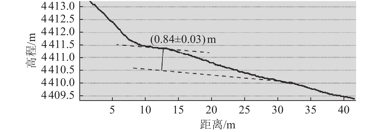
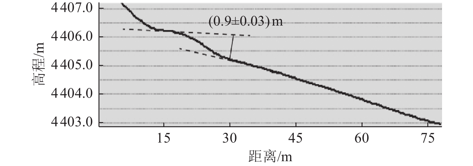
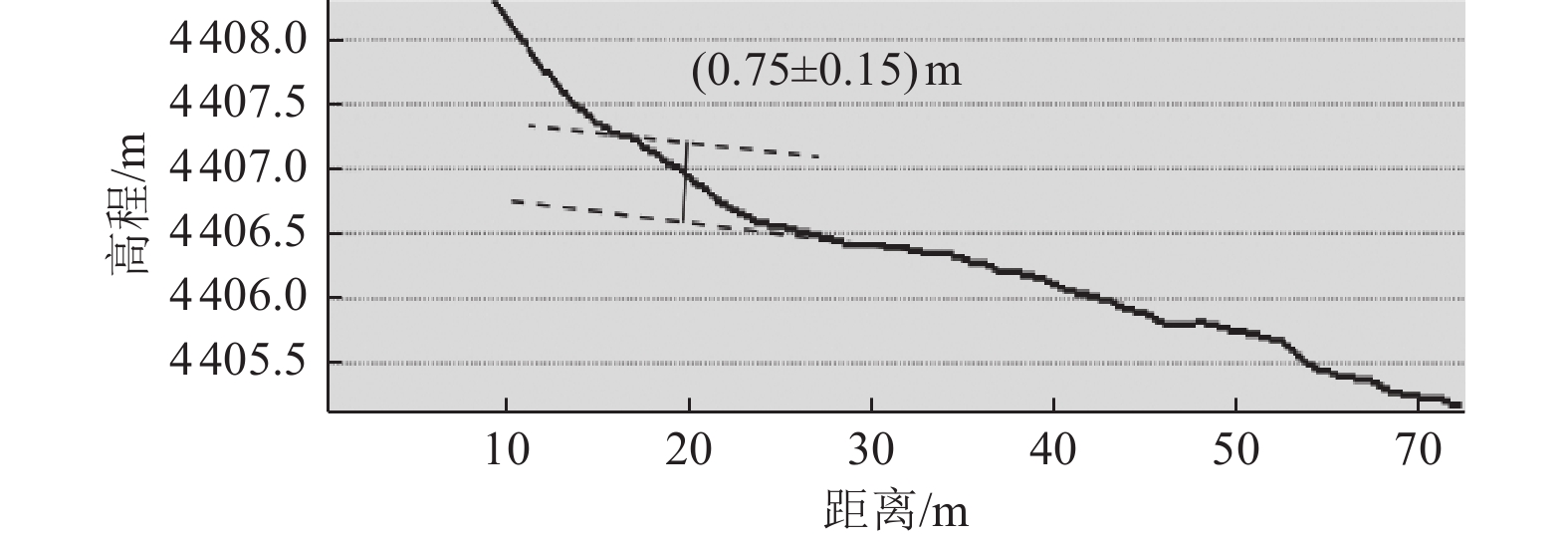
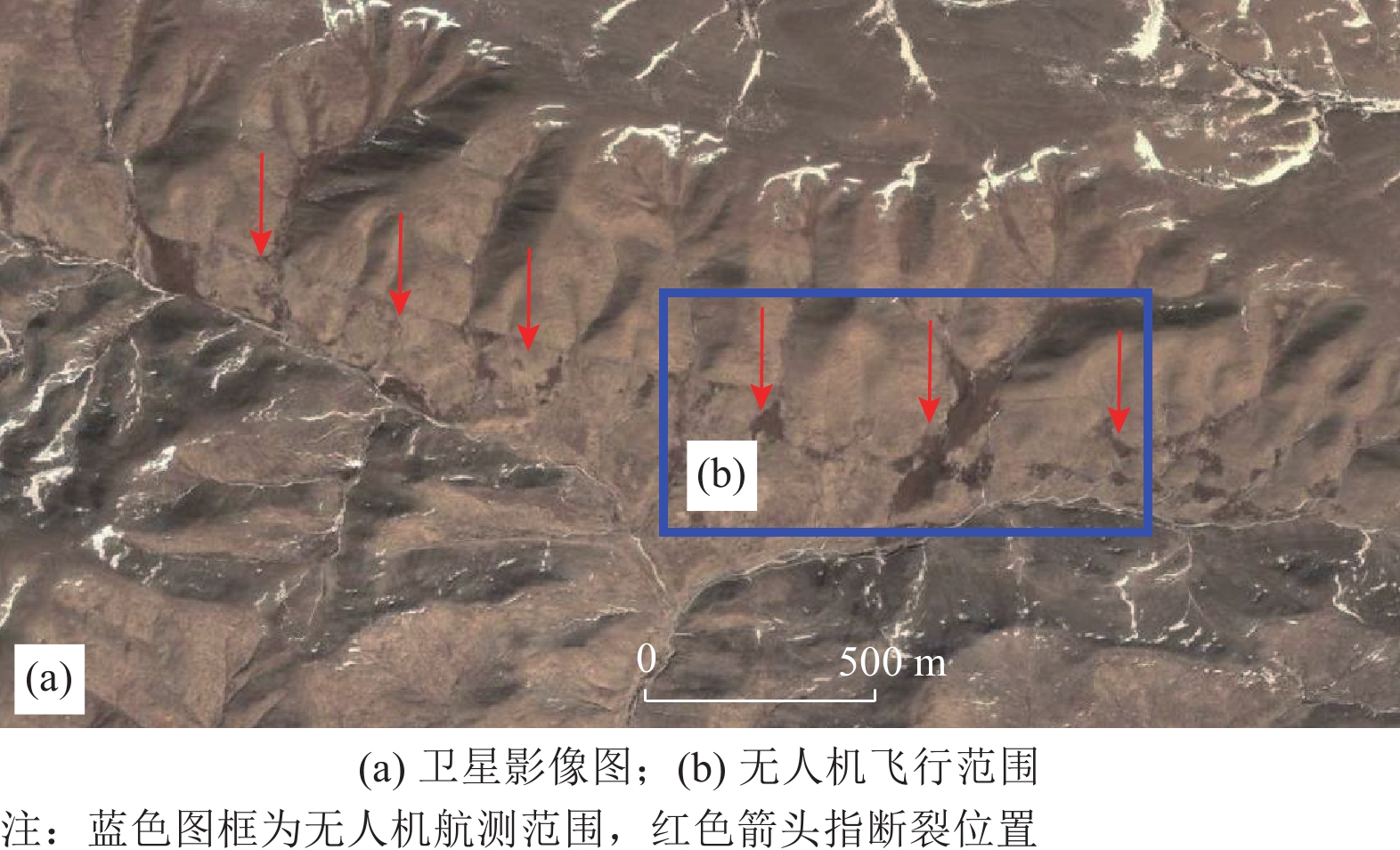
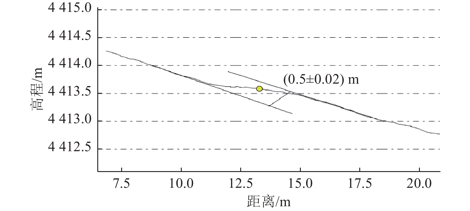
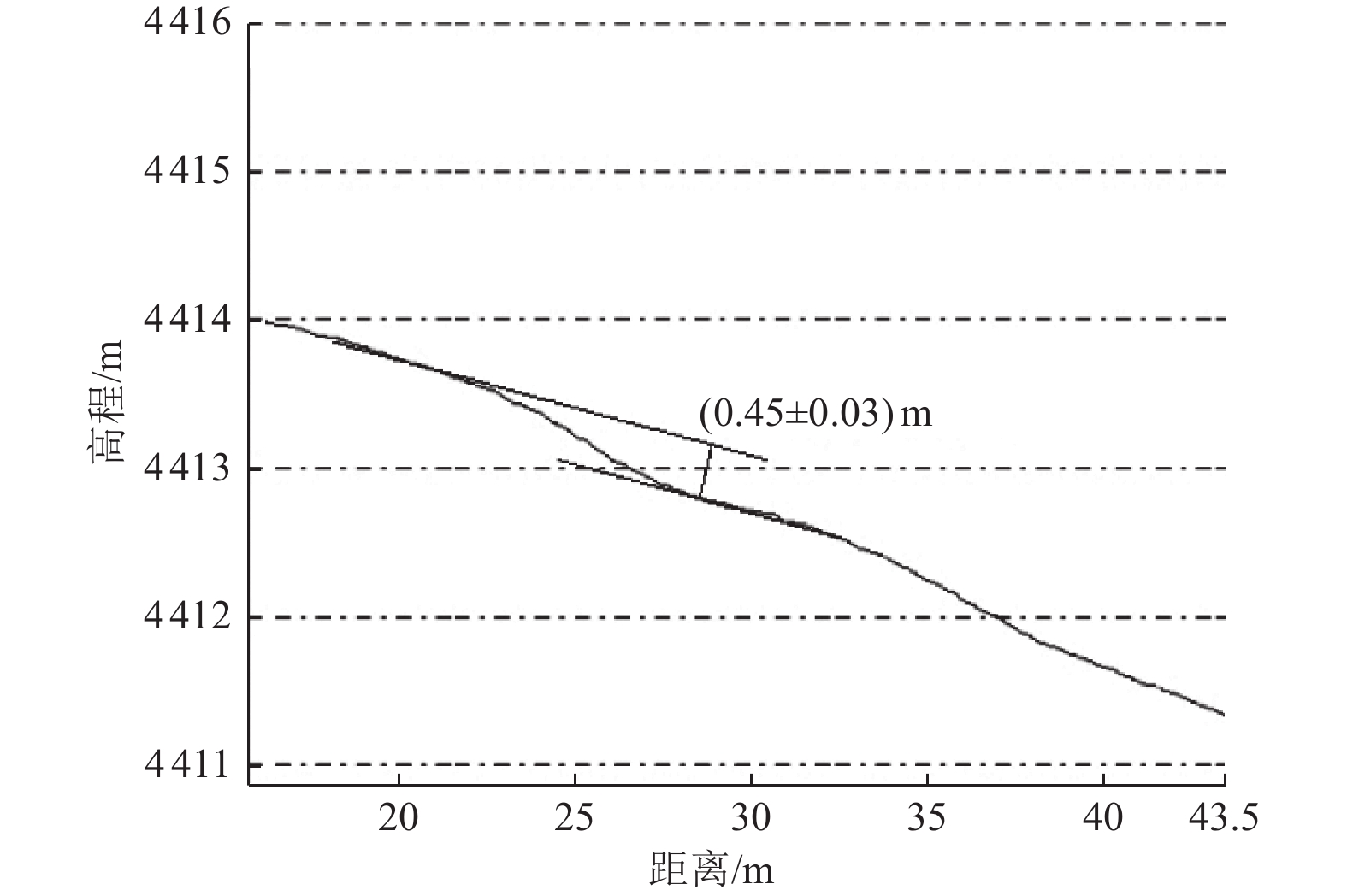
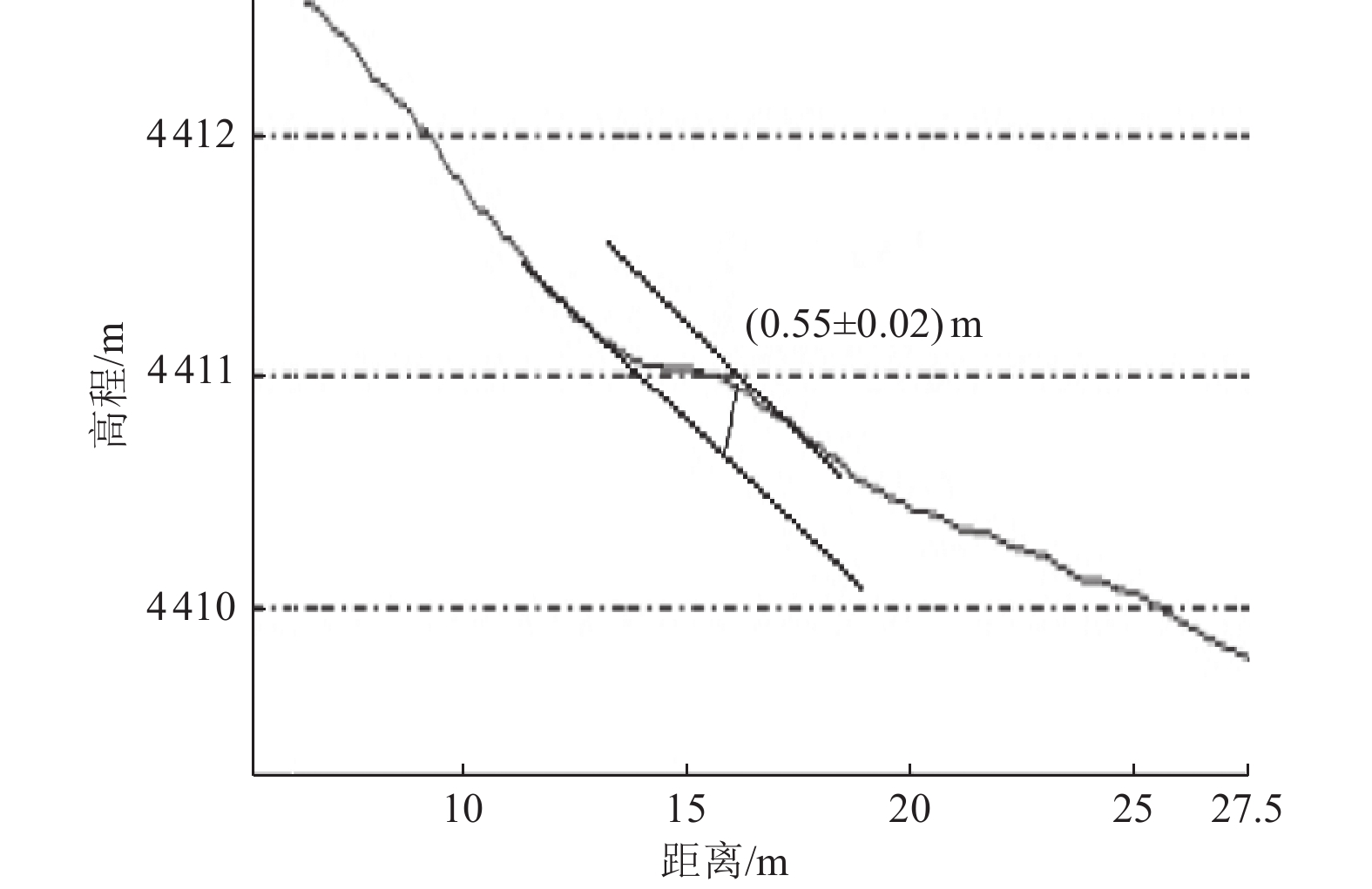
摘要: 无人机测量具有高清晰度、大比例尺、小面积、高现势性的优点,为地貌参数获取提供更准确可靠的活动构造定量参数,克服传统测量方法工作量大、效率低、受自然条件限制等缺点,可提供厘米级定位数据,从而显著提升图像元数据的绝对精度。利用大疆精灵4 RTK小型多旋翼高精度航测无人机,获取昆中断裂(巴隆-温泉段)在龙通村北的高精度DEM地貌数据,通过对微地貌的提取,初步确定断裂在该处的水平位错量为2.1~15.4 m。分析获取的8条陡坎剖面,认为其中5条陡坎形成后受到水流侵蚀作用较小,陡坎高度基本相似,断裂实际垂直位错量为0.6~0.9 m。研究结果表明,无人机航测技术是识别复杂地貌构造信息并提取相关活动构造参数的有效手段,可为断裂的定量研究提供可靠的数据基础。Abstract: Uav measurement has the advantages of high definition, large scale, small area and high present situation, providing more accurate and reliable quantitative parameters of active structure for geomorphic parameter acquisition, overcoming the shortcomings of traditional measurement methods such as heavy workload, low efficiency and limited by natural conditions, and providing centimeter-level positioning data, thus significantly improving the absolute accuracy of image metadata. In this paper, the high-precision DEM landform data of Kunzhong fault (Balong Wenquan section) in Longtong village are obtained by using Dajiang spirit 4rtk multi rotor aerial survey UAV. Through the extraction of micro landform, it is preliminarily determined that the horizontal dislocation of the fault is 2.1 ~ 15.4 m. According to the analysis of the eight scarp profiles obtained, it is considered that five scarp is less eroded by water flow after its formation, the height of the scarp is basically similar, and the actual vertical dislocation of the fault is about 0.6~0.9 m. It is preliminarily considered that UAV aerial survey technology is an effective means to identify complex geomorphic structure information and extract relevant active structural parameters, which provides a reliable data basis for the quantitative study of faults.
-
Key words:
- UAV survey /
- Kunzhong fault /
- Fault scarps /
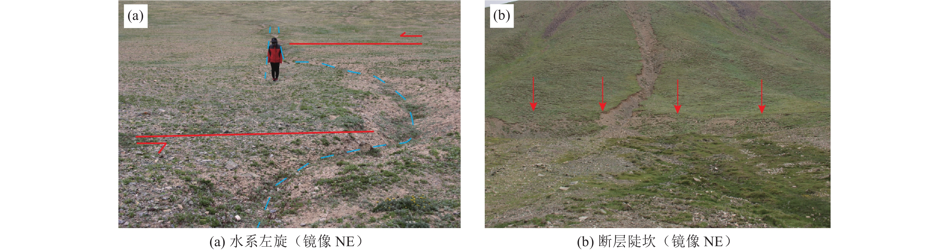
- Water system sinistral
-

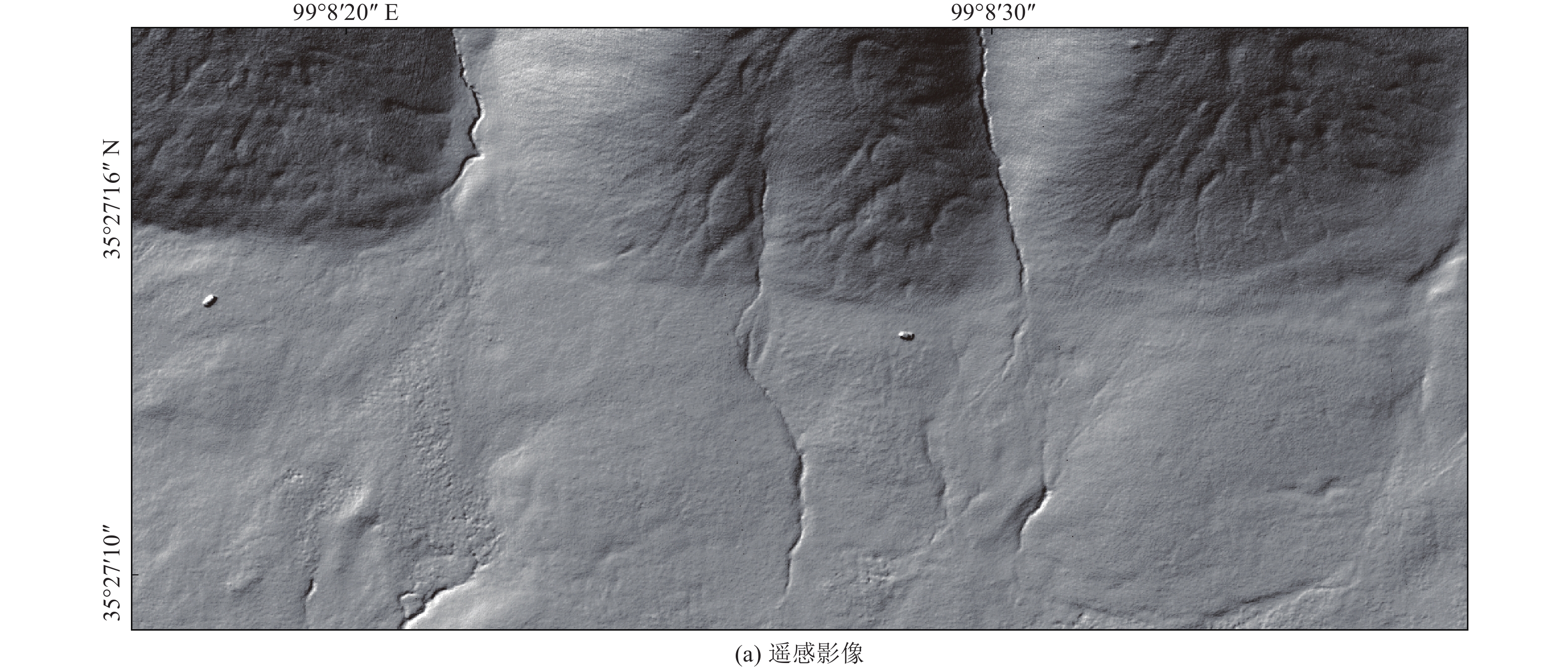
图 4 点1基于DEM数据的水系位错恢复
Figure 4. Water system dislocation recovery based on DEM data of point one
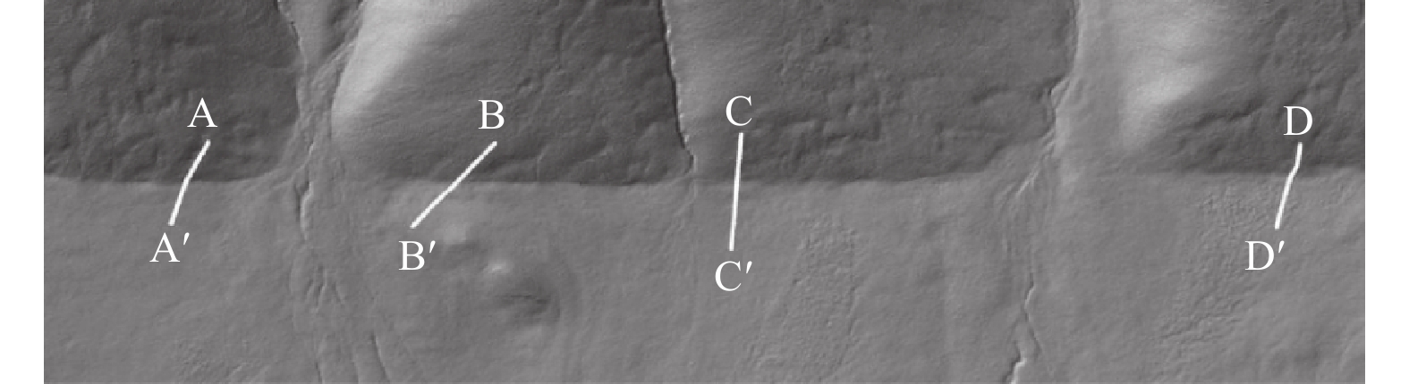
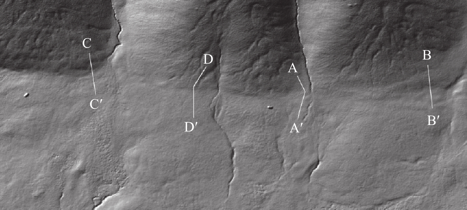
图 5 点1 DEM提取剖面位置示意
Figure 5. Schematic diagram of DEM extraction section position of point one
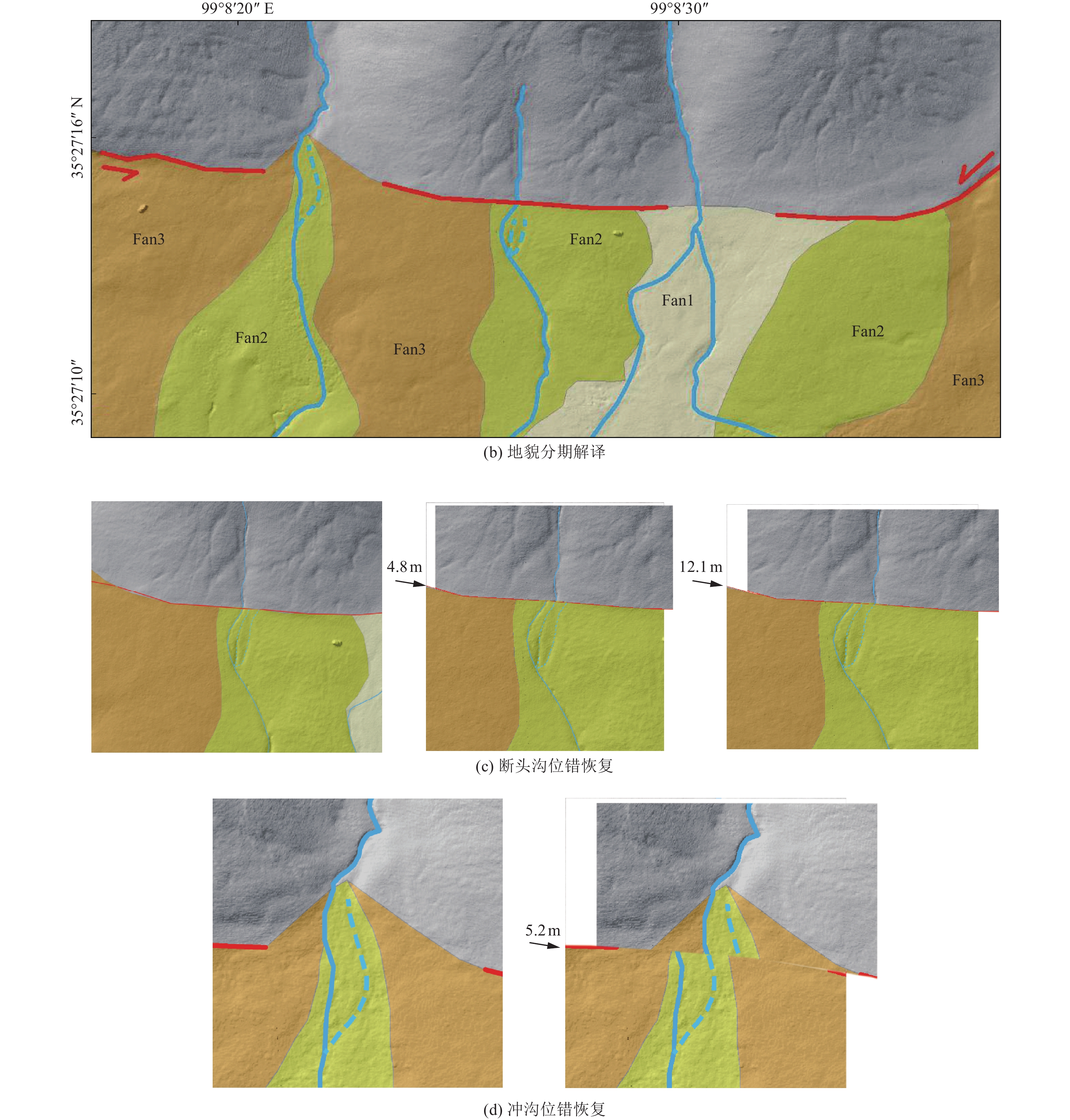
12 点2基于DEM数据的水系位错恢复
12. Water system dislocation recovery based on DEM data of point two
-
毕海芸, 郑文俊, 曾江源等, 2017. SfM摄影测量方法在活动构造定量研究中的应用. 地震地质, 39(4): 656—674 doi: 10.3969/j.issn.0253-4967.2017.04.003Bi H. Y. , Zheng W. J. , Zeng J. Y. , et al. , 2017. Application of SfM photogrammetry method to the quantitative study of active tectonics. Seismology and Geology, 39(4): 656—674. (in Chinese) doi: 10.3969/j.issn.0253-4967.2017.04.003 高建彩, 2022. 倾斜摄影测量在智慧城市建设中的应用. 黑龙江科学, 13(6): 91—93 doi: 10.3969/j.issn.1674-8646.2022.06.027Gao J. C. , 2022. Application of tilt photogrammetry in smart city construction. Heilongjiang Science, 13(6): 91—93. (in Chinese) doi: 10.3969/j.issn.1674-8646.2022.06.027 刘超, 雷启云, 余思汗等, 2021. 基于无人机摄影测量技术的地震地表破裂带定量参数提取——以1709年中卫南M7½地震为例. 地震学报, 43(1): 113—123 doi: 10.11939/jass.20200039Liu C. , Lei Q. Y. , Yu S. H. , et al. , 2021. Using UAV photogrammetry technology to extract the Quanti-Tative parameters of earthquake surface rupture zone: a case study of the southern Zhongwei M7½ earthquake in 1709. Acta Seismologica Sinica, 43(1): 113—123. (in Chinese) doi: 10.11939/jass.20200039 刘卫刚, 马静, 2015. 浅谈GPS-PPK技术在1: 1万基础测绘中的应用. 测绘技术装备, 17(2): 80—81. doi: 10.3969/j.issn.1674-4950.2015.02.027 罗国文, 阴志宏, 杨树文, 2012. 断裂构造遥感识别和提取方法的现状与展望. 山东国土资源, 28(2): 29—33 doi: 10.3969/j.issn.1672-6979.2012.02.010Luo G. W. , Yin Z. H. , Yang S. W. , 2012. Present condition and prospect of ertracton and identification methods by using remote sensing technology in faults. Shandong Land and Resources, 28(2): 29—33. (in Chinese) doi: 10.3969/j.issn.1672-6979.2012.02.010 马建, 黄帅堂, 吴国栋, 2019. 基于微型无人机摄影测量技术的微构造信息提取研究——以博-阿断裂乌苏通沟东岸为例. 中国地震, 35(3): 550—557 doi: 10.3969/j.issn.1001-4683.2019.03.013Ma J. , Huang S. T. , Wu G. D. , 2019. Microstructure information extraction based on the UAV photogrammetry technology-a case study of the bolokenu-aqikekuduke fault on the east bank of Wusutonggou. Earthquake Research in China, 35(3): 550—557. (in Chinese) doi: 10.3969/j.issn.1001-4683.2019.03.013 潘家伟, 李海兵, Van Der Woerd J. 等, 2007. 西昆仑山前冲断带晚新生代构造地貌特征. 地质通报, 26(10): 1368—1379 doi: 10.3969/j.issn.1671-2552.2007.10.014Pan J. W. , Li H. B. , Van Der Woerd J. , et al. , 2007. Late cenozoic morphotectonic features of the thrust belt in the front of the west Kunlun mountains. Geological Bulletin of China, 26(10): 1368—1379. (in Chinese) doi: 10.3969/j.issn.1671-2552.2007.10.014 魏占玉, Ramon A. , 何宏林等, 2015. 基于SfM方法的高密度点云数据生成及精度分析. 地震地质, 37(2): 636—648 doi: 10.3969/j.issn.0253-4967.2015.02.024Wei Z. Y. , Ramon A. , He H. L. , et al. , 2015. Accuracy analysis of terrain point cloud acquired by "Structure from Motion" using aerial photos. Seismology and Geology, 37(2): 636—648. (in Chinese) doi: 10.3969/j.issn.0253-4967.2015.02.024 姚生海, 盖海龙, 殷翔等, 2021. 青海玛多MS7.4地震地表破裂带的基本特征和典型现象. 地震地质, 43(5): 1060—1072Yao S. H. , Gai H. L. , Yin X. , et al. , 2021. The basic characteristics and typical phenomena of the surface rupture zone of the Maduo MS7.4 earthquake in Qinghai. Seismology and Geology, 43(5): 1060—1072. (in Chinese) 曾秋生, 1999. 青海地震综合研究. 北京: 地震出版社. 朱海斌, 王妍, 李亚梅, 2018. 基于无人机的露天矿区测绘研究. 煤炭工程, 50(10): 162—166Zhu H. B. , Wang Y. , Li Y. M. , 2018. Surveying and mapping of open-pit mining area using unmanned aerial vehicle. Coal Engineering, 50(10): 162—166. (in Chinese) 朱逍贤, 2018. 基于无人机倾斜摄影制作真正射影像研究. 成都: 成都理工大学.Zhu X. X., 2018. The study of the real projective image based on TDOM. Chengdu: Chengdu University of Technology. (in Chinese) -

 下载:
下载:


 点击查看大图

图(18)
计量
- 文章访问数: 236
- HTML全文浏览量: 62
- PDF下载量: 39
- 被引次数: 0
