
The Extraction Method of Swath Topographic Profile in Spherical Coordinate SystemA Study from the Himalayan Arc orogenic Belt
-
摘要: 带状地形剖面是以高程为纵向参考,以距剖面起始端点的距离为横向参考进行制图表达。由于其可真实地反映地表形态,是新构造和活动构造地貌研究中的基本参考和研究对象。随着数字化基础地理信息成果的普及,很多GIS软件可实现地形剖面的自动化提取。但以往方法的位置信息均是建立在剖面投影平面的基础上,当研究区域范围过大,会引入非构造变形,为消除该影响,提出基于球面坐标系统的带状地形剖面图制作方法。该方法不仅适用于小型地质构造,也适用于喜马拉雅弧形造山带等大型地质构造,可提取出更接近真实地形的地形剖面。Abstract: The swath topographic profile is represented by elevation as the vertical axis and the distance from the beginning end of the profile as the horizontal axis. Because it can truly reflect geomorphological features, it is a basic reference and research object in the study of neotectonics and active tectonics. With the popularization of basic digital geographic information, many GIS software can realize the automatic extraction of topographic profile. However, the generation of topographic profile is almost based on projection.Therefore, no matter what kind of map projection is chosen, non-structural deformation will be introduced when the study area is too large. In order to eliminate this artificial distortion, a new method of making swath topographic profiles based on spherical coordinate system is proposed in this paper. It is not only suitable for small geological structures, but also for huge crust-scale structures, such as the Himalayan orogenic belt. The extracted topographic profiles could be much closer to the real terrain.
-
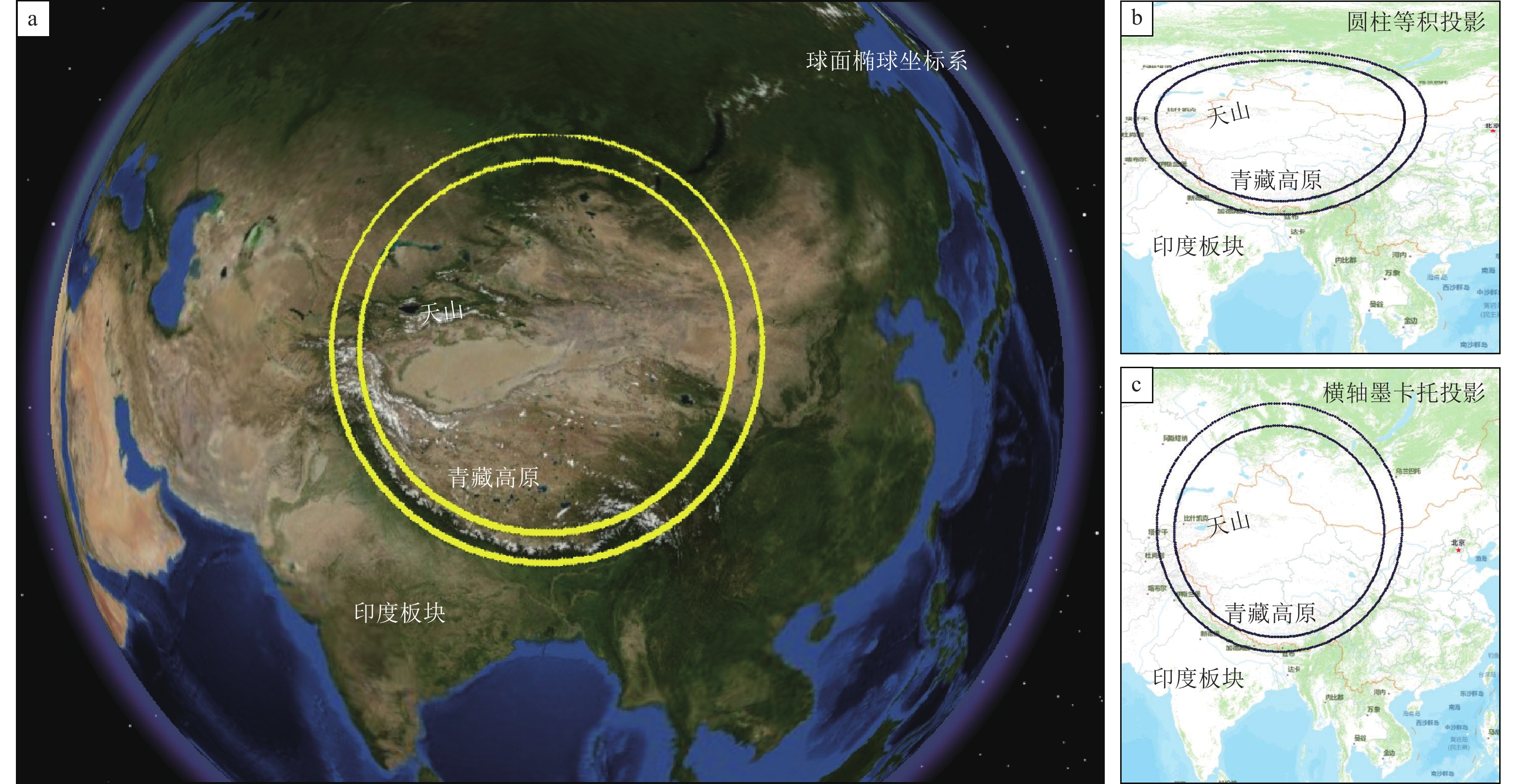
图 1 不同投影方式引起的非构造变形示意(以穿过喜马拉雅弧形造山带的环形为例)
Figure 1. The unreal deformation introduced by different projections (we take the annulus covering the Himalayan orogenic belt as an example)

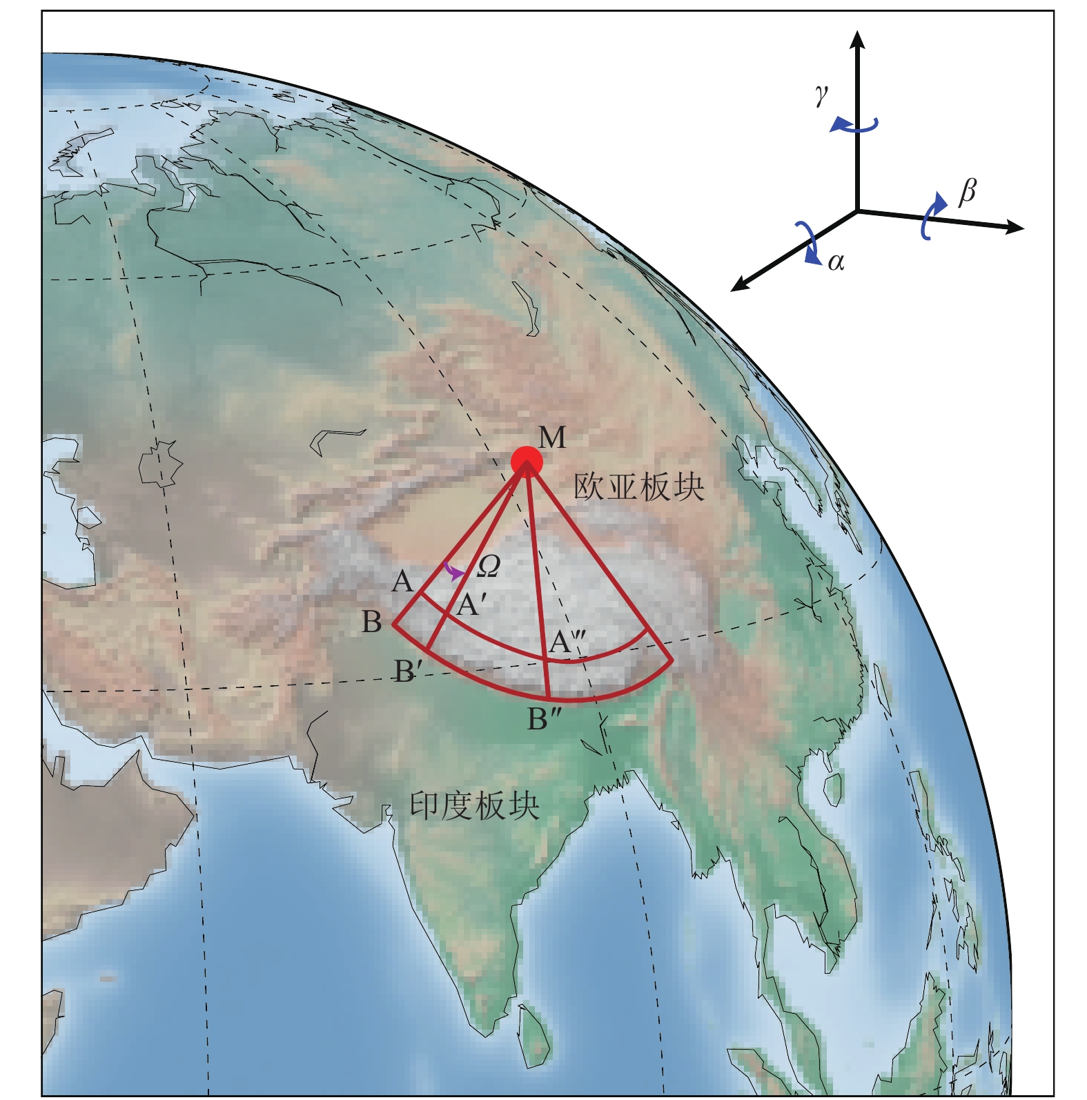
图 2 喜马拉雅造山带位置及条带状地形剖面提取结果
Figure 2. Location and the topographic swath profile of the Himalayan orogenic belt
-
[1] 丁林, 钟大赉, 2013. 印度与欧亚板块碰撞以来东喜马拉雅构造结的演化. 地质科学, 48(2): 317—333Ding L. , Zhong D. L. , 2013. The tectonic evolution of the eastern Himalaya syntaxis since the collision of the Indian and Eurasian plates. Chinese Journal of Geology, 48(2): 317—333. (in Chinese) [2] 王春范, 2018. 基于ArcGIS环境的地形剖面图制作方法. 城市勘测, (6): 124—127 doi: 10.3969/j.issn.1672-8262.2018.06.031Wang C. F. , 2018. The method of making profile of topography based on ArcGIS environment. Urban Geotechnical Investigation & Surveying, (6): 124—127. (in Chinese) doi: 10.3969/j.issn.1672-8262.2018.06.031 [3] 张会平, 刘少峰, 2004. 利用DEM进行地形高程剖面分析的新方法. 地学前缘, 11(3): 226. doi: 10.3321/j.issn:1005-2321.2004.03.036 [4] Bendick R., Bilham R., 2001. How perfect is the Himalayan arc? Geology, 29(9): 791—794. [5] Bian S. , Gong J. F. , Zuza A. V. , et al. , 2020. Late Pliocene onset of the Cona rift, eastern Himalaya, confirms eastward propagation of extension in Himalayan-Tibetan orogen. Earth and Planetary Science Letters, 544: 116383. doi: 10.1016/j.jpgl.2020.116383 [6] Burbank D. W. , Anderson R. S. , 2013. Tectonic geomorphology, second edition. Environmental and Engineering Geoscience, 19(2): 198—200. doi: 10.2113/gseegeosci.19.2.198 [7] Ding L. , Zhong D. L. , Yin A. , et al. , 2001. Cenozoic structural and metamorphic evolution of the eastern Himalayan syntaxis (Namche Barwa). Earth and Planetary Science Letters, 192(3): 423—438. doi: 10.1016/S0012-821X(01)00463-0 [8] Fielding E., Isacks B., Barazangi M., et al., 1994. How flat is Tibet? Geology, 22(2): 163—167. [9] Grohmann C. H. , 2004. Morphometric analysis in geographic information systems: applications of free software GRASS and R. Computers & Geosciences, 30(9—10): 1055—1067. [10] Molnar P. , Lyon-Caent H. , 1989. Fault plane solutions of earthquakes and active tectonics of the Tibetan Plateau and its margins. Geophysical Journal International, 99(1): 123—153. doi: 10.1111/j.1365-246X.1989.tb02020.x -

 下载:
下载:
 点击查看大图
图(3)
计量
- 文章访问数: 255
- HTML全文浏览量: 80
- PDF下载量: 14
- 被引次数: 0
