
Application of 3D Laser Scanning and Quantitative Morphology Analysis Method to Bedrock Fault Surface in Paleo-seismic Research in Bedrock Area
-
摘要: 由于对第四纪地层的严重依赖,传统古地震探槽研究方法在基岩区难以发挥作用,导致无法获取基岩区断层的强震活动历史。本研究以山西地堑系的交城断裂为目标断裂,以断裂北段2处基岩断层面为研究对象,通过三维激光扫描技术获取基岩断层面高精度形貌,基于变差函数法结合滑动窗口操作量化断层表面形貌特征,开展在基岩区提取断裂古地震信息的实例研究。结果显示,2处基岩断层面的形貌在高度上具有明显的分段特征,指示了断层面在地震事件作用下的分段出露过程。这种断层面形貌分段特征可以用来识别古地震事件和同震位移量。在思西村基岩断层面上,识别出由老到新的3次古地震事件,同震倾滑位移量依次为2.0 m、1.9 m和2.3 m,在上兰镇基岩断层面上,识别出由老到新的3次古地震事件,同震倾滑位移量依次为1.4 m、2.5 m和2.0 m,指示了交城断裂北、中段具有产生同震位移量大于2 m、震级大于7.5级的破裂型地震的能力。上述研究成果表明,基于三维激光扫描和形貌量化分析方法开展基岩断层面古地震研究,可以准确而高效地识别古地震事件次数和同震位移量,扩展古地震的研究对象,拓宽古地震的研究空间。在未来的研究中,可以适时地开展宇宙成因核素测年以测定断层面的暴露年龄,获得发震年代,给予地震序列年龄框架。Abstract: Due to the heavy reliance on Quaternary strata, traditional trench research methods are difficult to apply in the bedrock area, resulting in the inability to obtain strong seismic activity history on faults in the bedrock area. In this study, the Jiaocheng Fault in the Shanxi Rift is selected as the target fault, and the two bedrock fault surfaces in the northern segment are taken as the study object to carry out case studies. The variogram combined with the sliding window operation quantifies the morphologic features of the fault surface and extracts the paleo-seismic information. The results show that the morphology of the two bedrock fault surfaces has segmentation in height, indicating the exposure process of the fault surfaces under the action of periodic seismic events. Therefore, paleo-earthquake events and co-seismic slips can be identified by the morphological segments. Accordingly, three paleo-earthquake events were identified on the bedrock fault of Sixi village, and the co-seismic dip slips were 2.0 m, 1.9 m and 2.3 m in sequence. The co-seismic dip slips of the three paleoearthquakes are 1.4m, 2.5 m and 2.0 m in sequence. The results indicate that the northern segment of the northern and middle segments of Jiaocheng fault can produce ruptures with a co-seismic slip greater than 2 m and a magnitude greater than M7.5. The above results also show that the paleo-seismic research on bedrock fault surfaces based on t-LiDAR and morphological quantitative analysis can accurately and efficiently identify the number of paleo-earthquake and co-seismic slips, increase the objects of paleo-earthquakes, and expand research space of paleo-earthquakes. In future research, cosmogenic nuclide dating can be carried out timely to determine the exposure age of the fault surface, obtain the earthquake ages, and provide an age frame to the earthquake sequences.1) 2为区分变量,此处用D0表示同震位移,与刘静等(1996)中同震位移D含义一致。
-
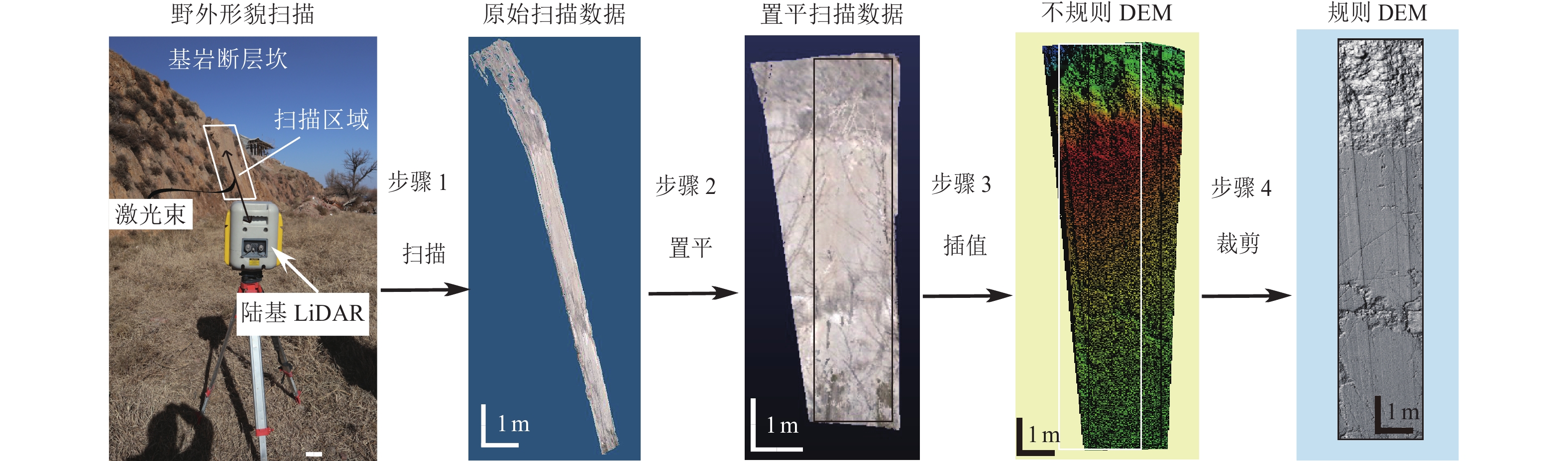
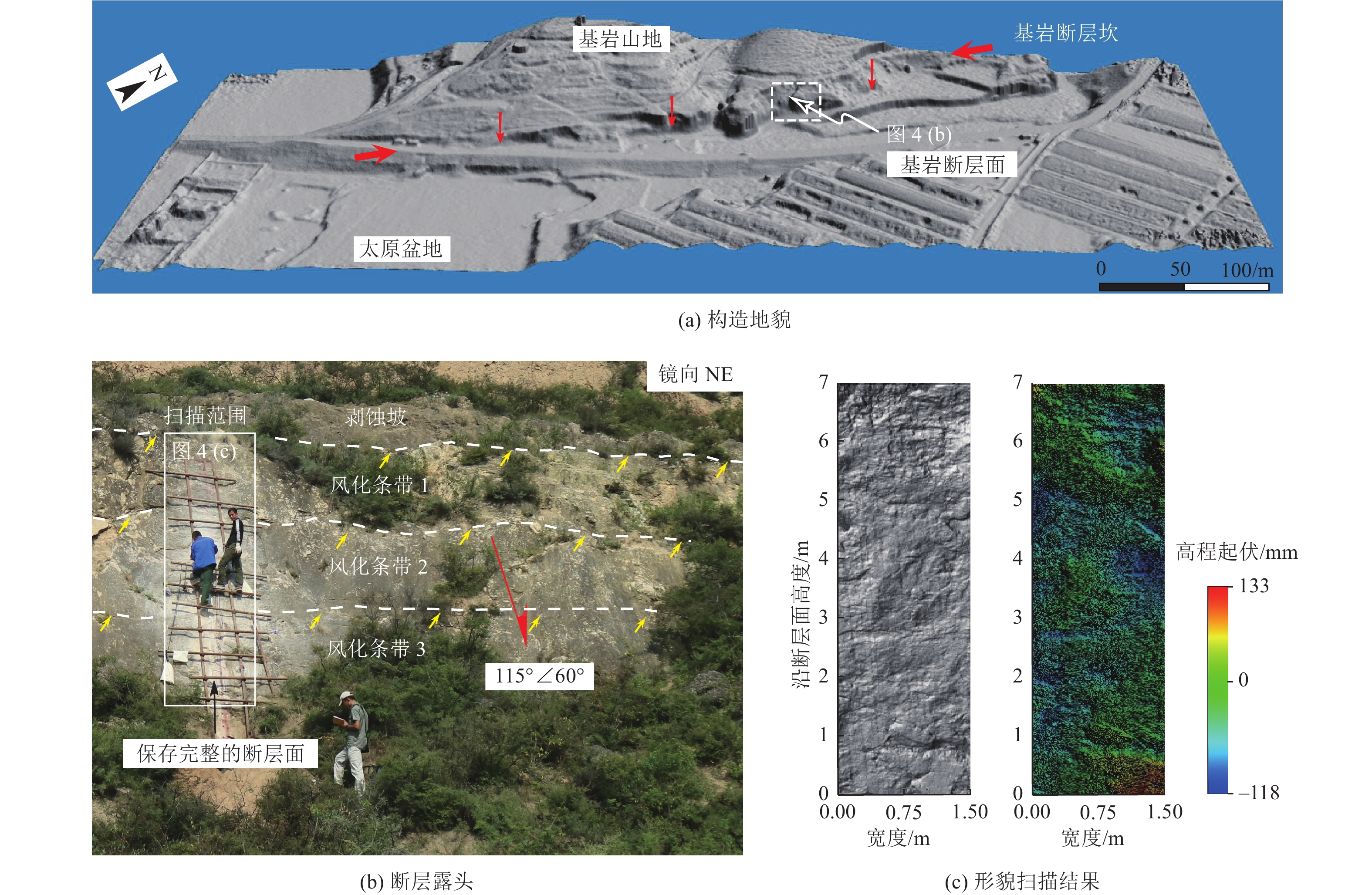
图 1 基岩断层面高精度形貌的扫描与处理
Figure 1. Scanning and processing of high-precision morphology of bedrock fault surfaces
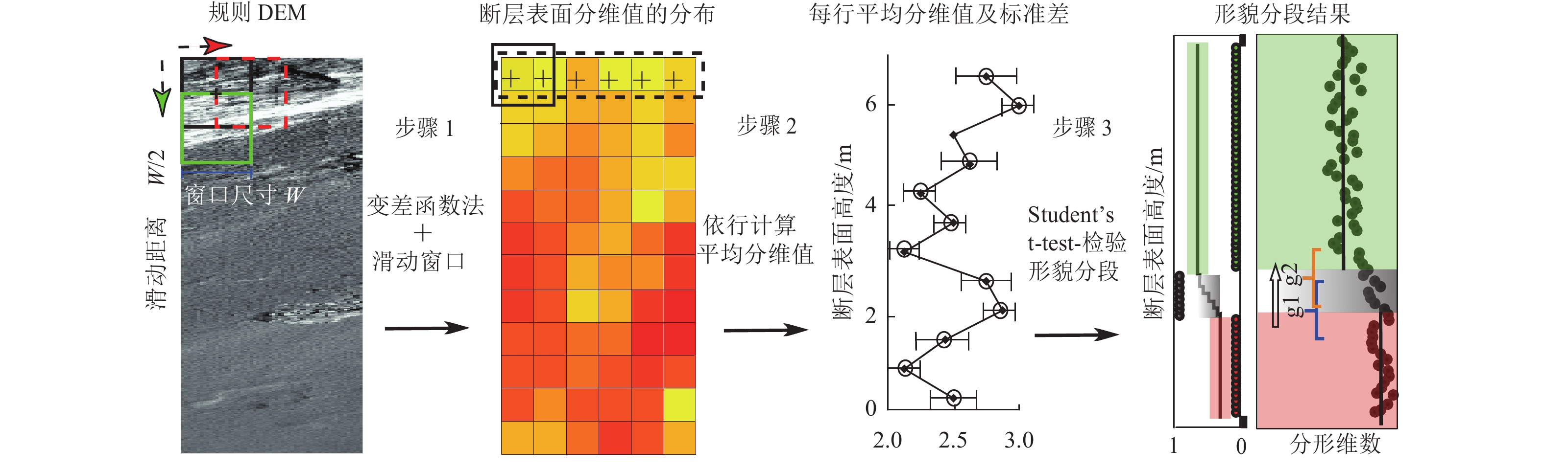
图 2 基岩断层面高精度形貌的量化分析
Figure 2. Quantitative analysis of high-precision morphology of bedrock fault surfaces
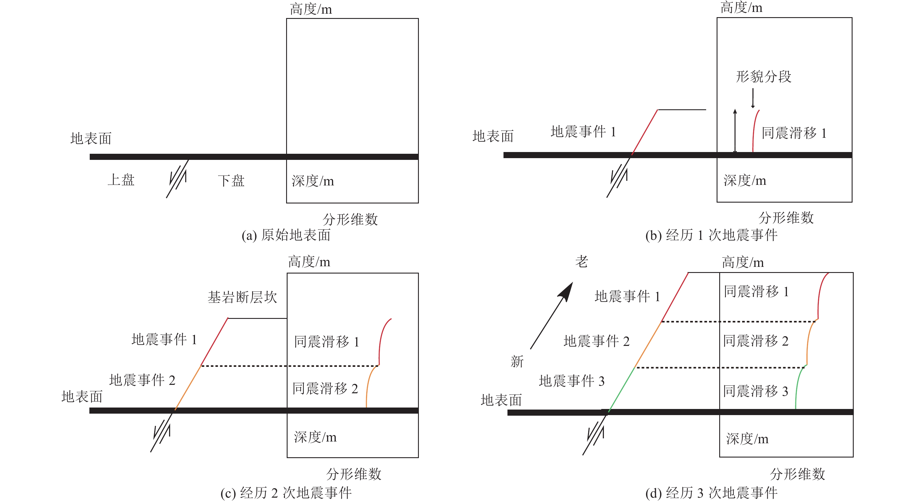
图 3 基岩断层面的出露过程和相应的形貌特征
Figure 3. The exposure process of the bedrock fault surface and the corresponding morphological characteristics

图 4 目标断裂与研究点的位置和基本信息
Figure 4. Location and basic information of the aimed fault and study points
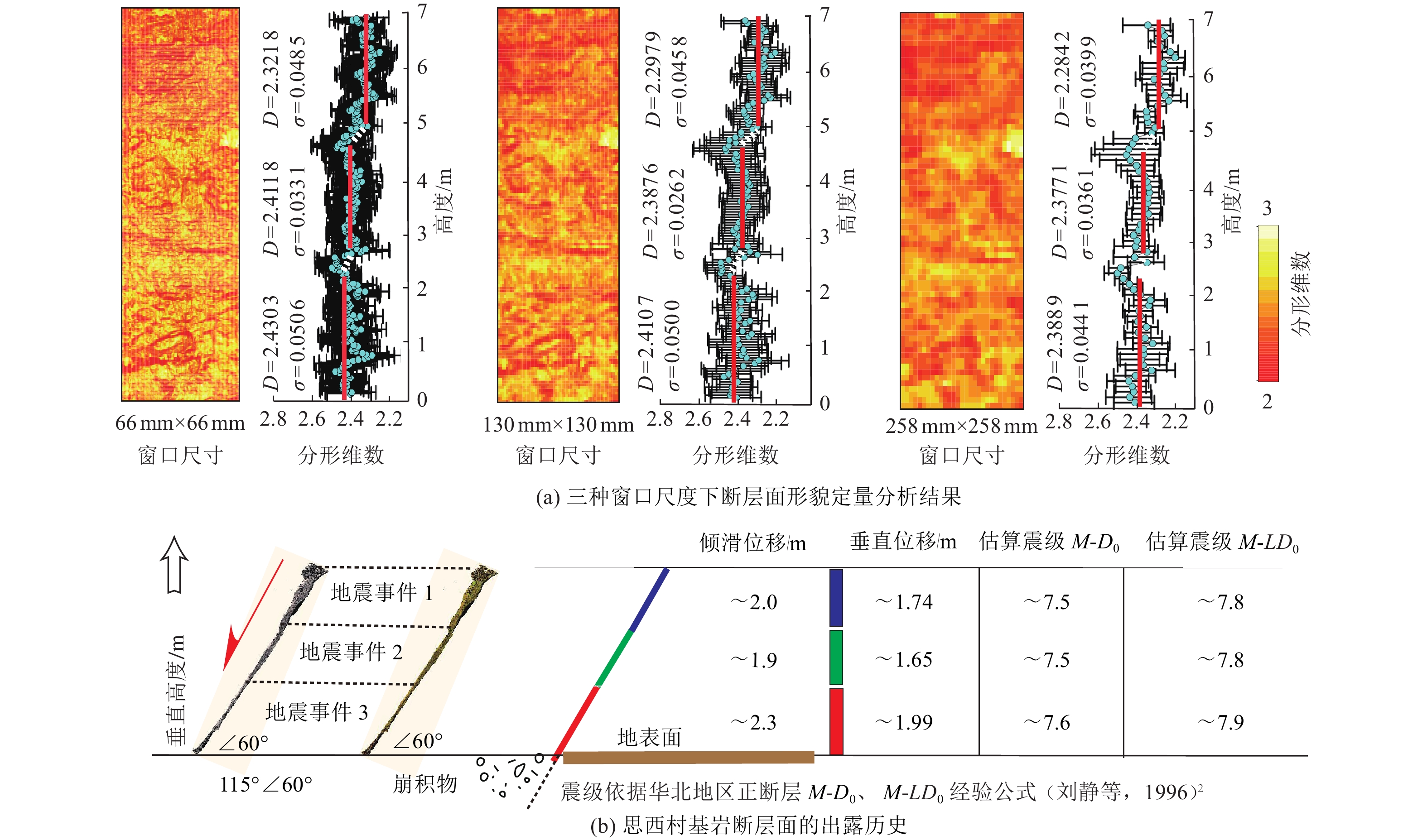
图 6 思西村基岩断层面形貌的定量分析和古地震事件识别结果
Figure 6. Quantitative morphology analysis and paleo-earthquake identification results for Sixi village bedrock fault surface
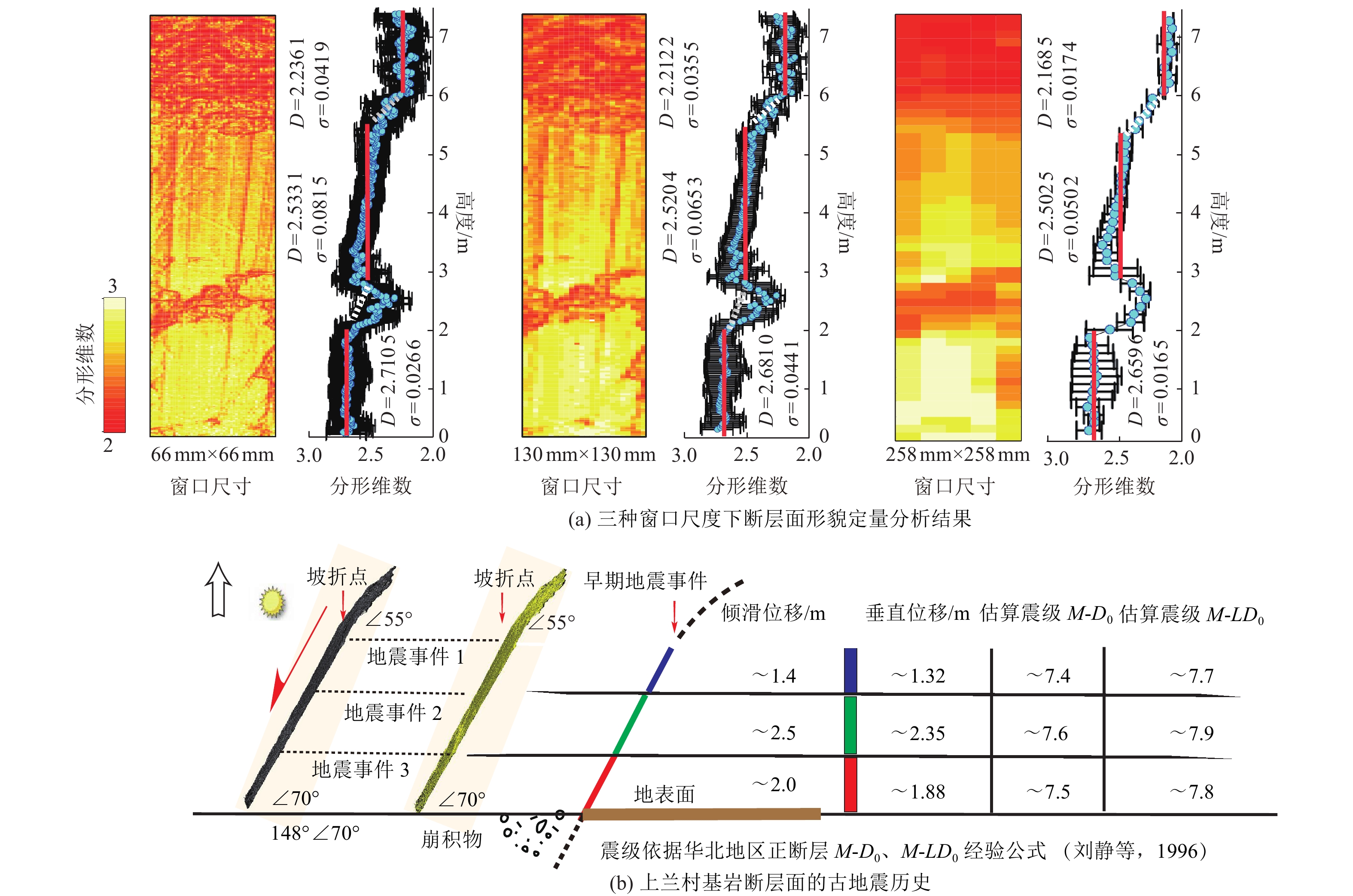
图 8 上兰镇基岩断层面形貌定量分析和古地震事件识别结果
Figure 8. Quantitative morphology and paleo-earthquake identification results of Shanglanzhen bedrock fault surface
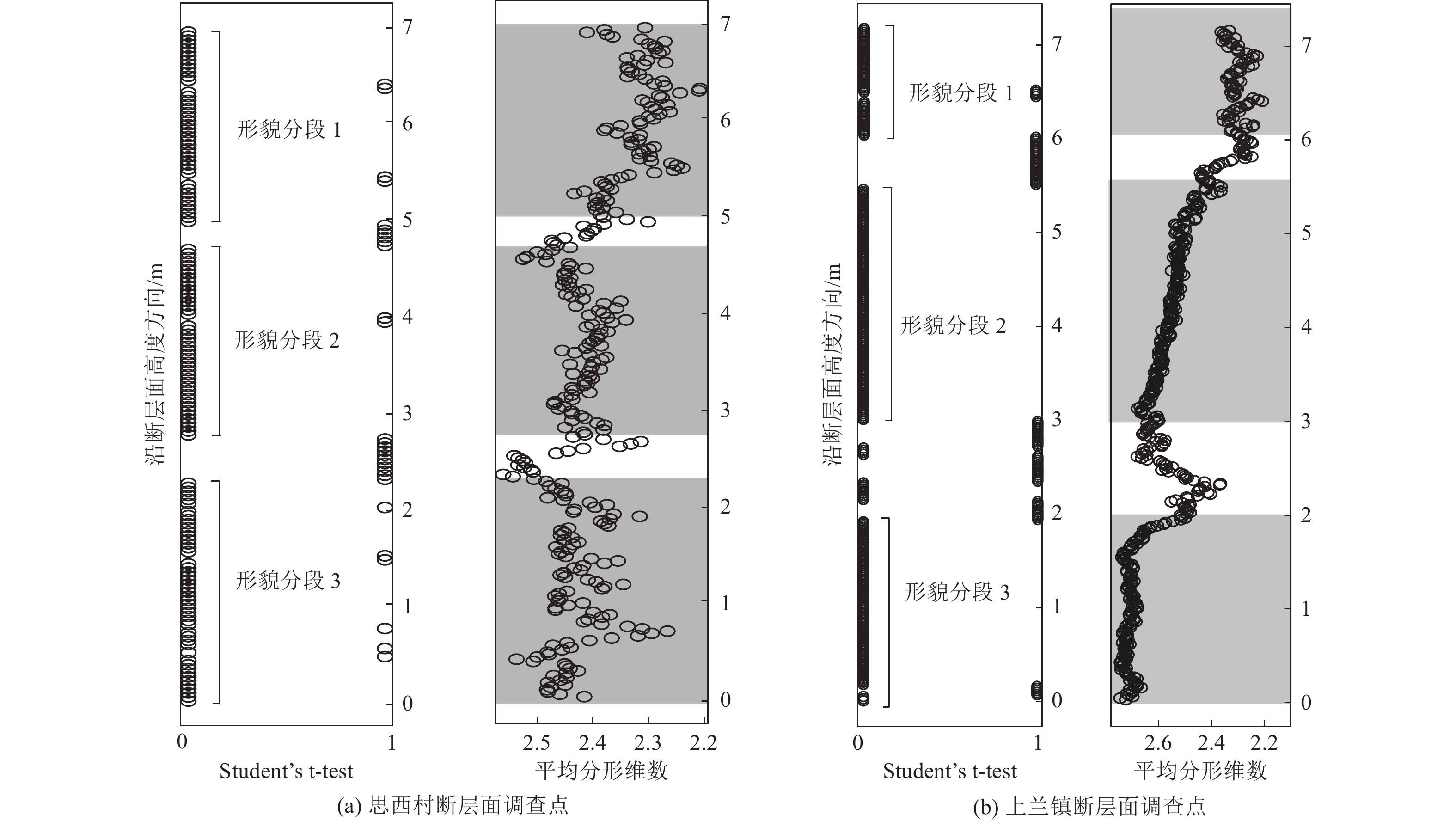
图 9 思西村和上兰镇调查点的Student’s t-test分段检验结果
Figure 9. Morphology segmentation results of Sixi village and Shanglanzhen survey points based on Student's t-test method
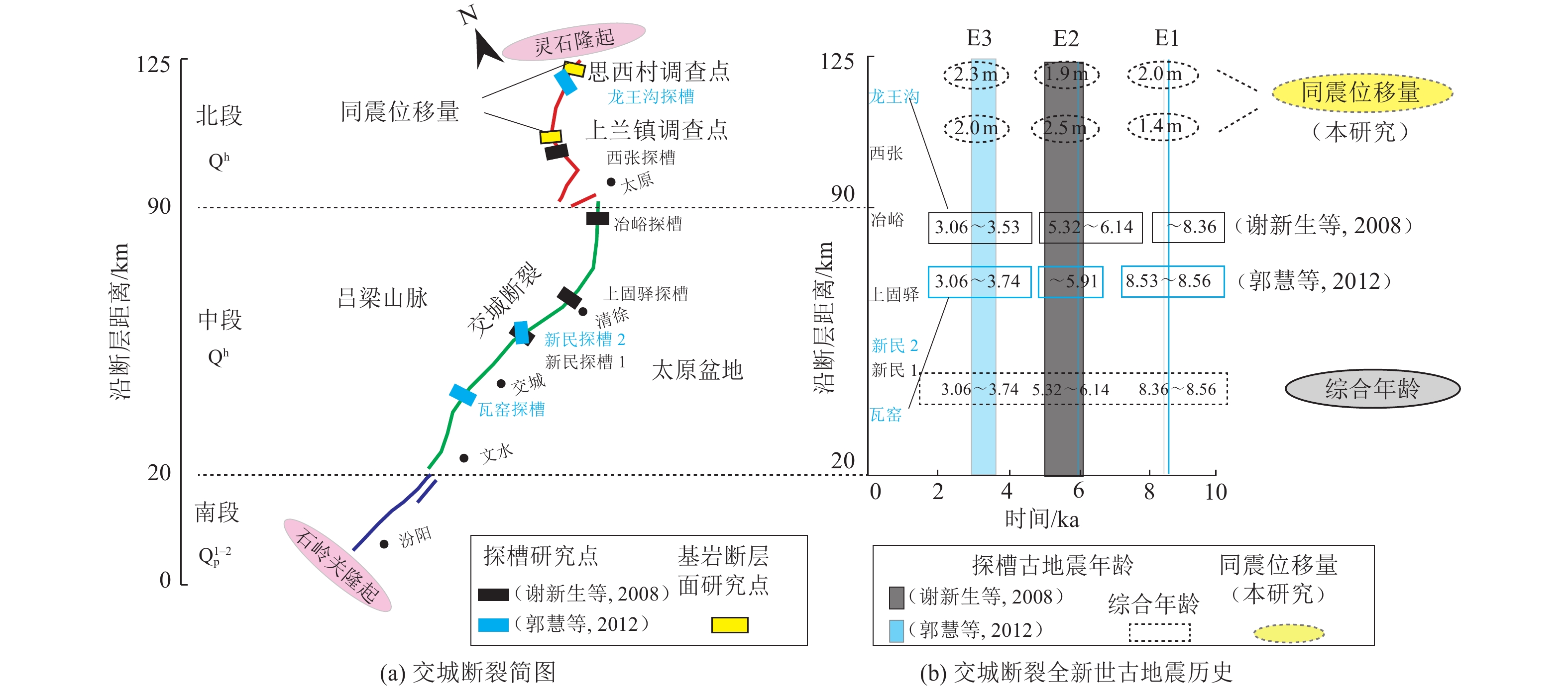
图 10 交城断裂简图与全新世以来古地震信息
Figure 10. Schematic map and paleoearthquake information of the JCF since the Holocene
表 1 思西村基岩断层面的分形维数与分段高度
Table 1. Characteristic fractal value (D)and heights of morphological segments on Sixi village bedrock fault surface
断层面 滑动窗口尺寸 分形维数(D) 标准差(σ) 下段 中段 上段 下段 中段 上段 思西村
断层面66 mm×66 mm 2.4303 2.4118 2.3218 0.0506 0.0331 0.0485 130 mm×130 mm 2.4107 2.3876 2.2979 0.0500 0.0262 0.0458 258 mm×258 mm 2.3889 2.3771 2.2842 0.0441 0.0361 0.0339 分段高度H/m / 2.3 1.9 2.0 / / /  下载: 导出CSV
表 2 上兰镇基岩断层面的分形维数和分段高度
Table 2. Characteristic fractal value (D) and heights of morphological segments on Shanglanzhen bedrock fault surface
断层面 滑动窗口尺寸 分形维数(D) 标准差(σ) 下段 中段 上段 下段 中段 上段 上兰镇
断层面66 mm×66 mm 2.7105 2.5331 2.2361 0.0266 0.0815 0.0419 130 mm ×130 mm 2.6810 2.5204 2.2122 0.0441 0.0653 0.0458 258 mm×258 mm 2.6596 2.5025 2.1685 0.0165 0.0502 0.0174 分段高度H/m / 2.0 2.5 1.4 / / /
下载: 导出CSV
-
[1] 郭慧, 江娃利, 谢新生, 2012. 山西交城断裂北端及中段3个大型探槽全新世断错现象分析. 地震地质, 34(1): 76—92 doi: 10.3969/j.issn.0253-4967.2012.01.008Guo H. , Jiang W. L. , Xie X. S. , 2012. Analysis of Holocene faulting phenomena revealed in the three trenches along the northern and central Jiaocheng Fault, Shanxi. Seismology and Geology, 34(1): 76—92. (in Chinese) doi: 10.3969/j.issn.0253-4967.2012.01.008 [2] 李峰, 徐锡伟, 陈桂华等, 2008. 高精度测量方法在汶川MS 8.0地震地表破裂带考察中的应用. 地震地质, 30(4): 1065—1075 doi: 10.3969/j.issn.0253-4967.2008.04.022Li F. , Xu X. W. , Chen G. H. , et al. , 2008. The application of different high-precision survey methods in the investigation of the MS 8.0 Wenchuan earthquake surface ruptures. Seismology and Geology, 30(4): 1065—1075. (in Chinese) doi: 10.3969/j.issn.0253-4967.2008.04.022 [3] 刘静, 汪良谋, 1996. 震级与地震破裂参数统计关系式系数的讨论. 地震地质, 18(3): 225—236Liu J. , Wang L. M. , 1996. Discussion on coefficients of statistical regressions between magnitude and earthquake rupture parameters. Seismology and Geology, 18(3): 225—236. (in Chinese) [4] 毛凤英, 张培震, 1995. 古地震研究的逐次限定方法与新疆北部主要断裂带的古地震研究. 活动断裂研究, (4): 153—164Mao F. Y. , Zhang P. Z. , 1995. Progressive constraining method in paleoseismic study and paleoearthquakes along the major active faults in northern Xinjiang. Research on Active Fault, (4): 153—164. (in Chinese) [5] 王林, 田勤俭, 李德文, 等, 2017. 蔚广盆地南缘断裂带唐山口段山前断层活动性研究. 震灾防御技术, 12(2): 319—328 doi: 10.11899/zzfy20170208Wang L. , Tian Q. J. , Li D. W. , et al. , 2017. The activity of the piedmont fault along the Tangshankou segment of Yuguang basin southern marginal fault. Technology for Earthquake Disaster Prevention, 12(2): 319—328. (in Chinese) doi: 10.11899/zzfy20170208 [6] 谢新生, 江娃利, 孙昌斌等, 2008. 山西交城断裂带多个大探槽全新世古地震活动对比研究. 地震地质, 30(2): 412—430 doi: 10.3969/j.issn.0253-4967.2008.02.007Xie X. S. , Jiang W. L. , Sun C. B. , et al. , 2008. Comparison study on Holocene paleoseismic activities among multi-trenches along the Jiaocheng Fault zone, Shanxi. Seismology and Geology, 30(2): 412—430. (in Chinese) doi: 10.3969/j.issn.0253-4967.2008.02.007 [7] Bi L. S., He H. L., Wei Z. Y., et al., 2012. Fractal properties of landforms in the ordos block and surrounding areas, China. Geomorphology, 175—176: 151—162. [8] Chase C. G. , 1992. Fluvial landsculpting and the fractal dimension of topography. Geomorphology, 5(1—2): 39—57. doi: 10.1016/0169-555X(92)90057-U [9] Davies S. , Hall P. , 1999. Fractal analysis of surface roughness by using spatial data. Journal of the Royal Statistical Society: Series B (Statistical Methodology), 61(1): 3—37. doi: 10.1111/1467-9868.00160 [10] Elliot J. K. , 1989. An investigation of the change in surface roughness through time on the foreland of Austre Okstindbreen, North Norway. Computers & Geosciences, 15(2): 209—217. [11] Galli P. , Galadini F. , Pantosti D. , 2008. Twenty years of paleoseismology in Italy. Earth-Science Reviews, 88(1—2): 89—117. doi: 10.1016/j.earscirev.2008.01.001 [12] Giaccio B. , Galadini F. , Sposato A. , et al. , 2003. Image processing and roughness analysis of exposed bedrock fault planes as a tool for paleoseismological analysis: results from the Campo Felice fault (central Apennines, Italy). Geomorphology, 49(3—4): 281—301. doi: 10.1016/S0169-555X(02)00191-5 [13] Goodall H. J. , Gregory L. C. , Wedmore L. N. J. , et al. , 2021. Determining histories of slip on normal faults with bedrock scarps using cosmogenic nuclide exposure data. Tectonics, 40(3): e2020TC006457. [14] He H. L. , Wei Z. Y. , Densmore A. , 2016. Quantitative morphology of bedrock fault surfaces and identification of paleo-earthquakes. Tectonophysics, 693: 22—31. doi: 10.1016/j.tecto.2016.09.032 [15] Jones R. R. , Kokkalas S. , McCaffrey K. J. W. , 2009. Quantitative analysis and visualization of nonplanar fault surfaces using terrestrial laser scanning (LiDAR)—The Arkitsa fault, Central Greece, as a case study. Geosphere, 5(6): 465—482. [16] Klinkenberg B., 1992. Fractals and morphometric measures: is there a relationship? Geomorphology, 5(1—2): 5—20. [17] Mandelbrot B. , 1967. How long is the coast of Britain? Statistical self-similarity and fractional dimension. Science, 156(3775): 636—638. doi: 10.1126/science.156.3775.636 [18] McCalpin J., 2009. Paleoseismology. 2nd ed. Burlington: Academic Press. [19] Palumbo L. , Benedetti L. , Bourlès D. , et al. , 2004. Slip history of the Magnola fault (Apennines, Central Italy) from 36Cl surface exposure dating: evidence for strong earthquakes over the Holocene. Earth and Planetary Science Letters, 225(1—2): 163—176. doi: 10.1016/j.jpgl.2004.06.012 [20] Power W. L. , Tullis T. E. , 1991. Euclidean and fractal models for the description of rock surface roughness. Journal of Geophysical Research: Solid Earth, 96(B1): 415—424. doi: 10.1029/90JB02107 [21] Ran Y. K. , Chen L. C. , Chen J. , et al. , 2010. Paleoseismic evidence and repeat time of large earthquakes at three sites along the Longmenshan fault zone. Tectonophysics, 491(1—4): 141—153. doi: 10.1016/j.tecto.2010.01.009 [22] Sagy A. , Brodsky E. E. , Axen G. J. , 2007. Evolution of fault-surface roughness with slip. Geology, 35(3): 283—286. doi: 10.1130/G23235A.1 [23] Sagy A. , Brodsky E. E. , 2009. Geometric and rheological asperities in an exposed fault zone. Journal of Geophysical Research: Solid Earth, 114(B2): B02301. [24] Sieh K. E. , 1978. Prehistoric large earthquakes produced by slip on the San Andreas Fault at Pallett Creek, California. Journal of Geophysical Research: Solid Earth, 83(B8): 3907—3939. doi: 10.1029/JB083iB08p03907 [25] Sieh K. E. , 1984. Lateral offsets and revised dates of large prehistoric earthquakes at Pallett Creek, southern California. Journal of Geophysical Research: Solid Earth, 89(B9): 7641—7670. doi: 10.1029/JB089iB09p07641 [26] Sung Q. C., Chen Y. C., Chao P. C., 1998. Spatial variation of fractal parameters and its geological implications. Terrestrial, Atmospheric and Oceanic Sciences, 9(4): 655—672. [27] Sung Q. C. , Chen Y. C. , 2004. Self-affinity dimensions of topography and its implications in morphotectonics: an example from Taiwan. Geomorphology, 62(3—4): 181—198. doi: 10.1016/j.geomorph.2004.02.012 [28] Wells D. L. , Coppersmith K. J. , 1994. New empirical relationships among magnitude, rupture length, rupture width, rupture area, and surface displacement. Bulletin of the Seismological Society of America, 84(4): 974—1002. [29] Wiatr T. , Papanikolaou I. , Fernández-Steeger T. , et al. , 2015. Bedrock fault scarp history: insight from t-LiDAR backscatter behaviour and analysis of structure changes. Geomorphology, 228: 421—431. doi: 10.1016/j.geomorph.2014.09.021 [30] Young J. J. , Arrowsmith J. R. , Colini L. , et al. , 2002. Three-dimensional excavation and recent rupture history along the Cholame segment of the San Andreas fault. Bulletin of the Seismological Society of America, 92(7): 2670—2688. doi: 10.1785/0120000604 [31] Zou J. J. , He H. L. , Yokoyama Y. , et al. , 2020. Seismic history of a bedrock fault scarp using quantitative morphology together with multiple dating methods: a case study of the Luoyunshan piedmont fault, southwestern Shanxi Rift, China. Tectonophysics, 788: 228473. doi: 10.1016/j.tecto.2020.228473 [32] Zou J. J., He H. L., Yokoyama Y., et al., 2021. Identification of Paleoearthquakes and Coseismic Slips on a Normal Fault Using High-Precision Quantitative Morphology: application to the Jiaocheng Fault in the Shanxi Rift, China. Lithosphere, (Special 2): 2550879. [33] Zreda M. , Noll J. S. , 1998. Ages of prehistoric earthquakes revealed by cosmogenic chlorine-36 in a bedrock fault scarp at Hebgen Lake. Science, 282(5391): 1097—1099. doi: 10.1126/science.282.5391.1097 -


 点击查看大图
计量
- 文章访问数: 432
- HTML全文浏览量: 94
- PDF下载量: 29
- 被引次数: 0
