
Measurement of Co-seismic Dip-slip Based on 3D Point Clouds from UAV Oblique PhotogrammetryA Case Study of Surface Rupture of the 2021 Maduo MS7.4 Earthquake
-
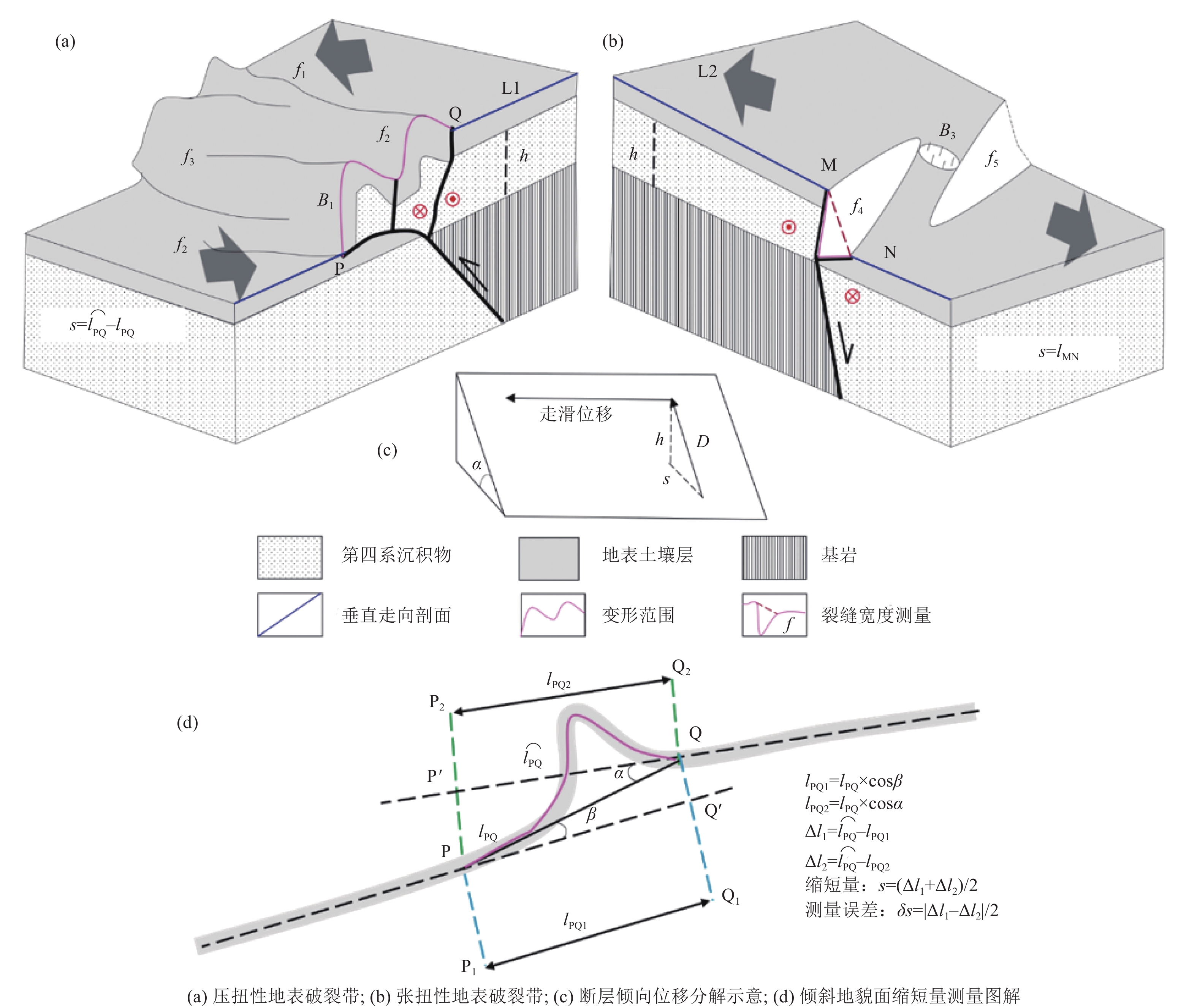
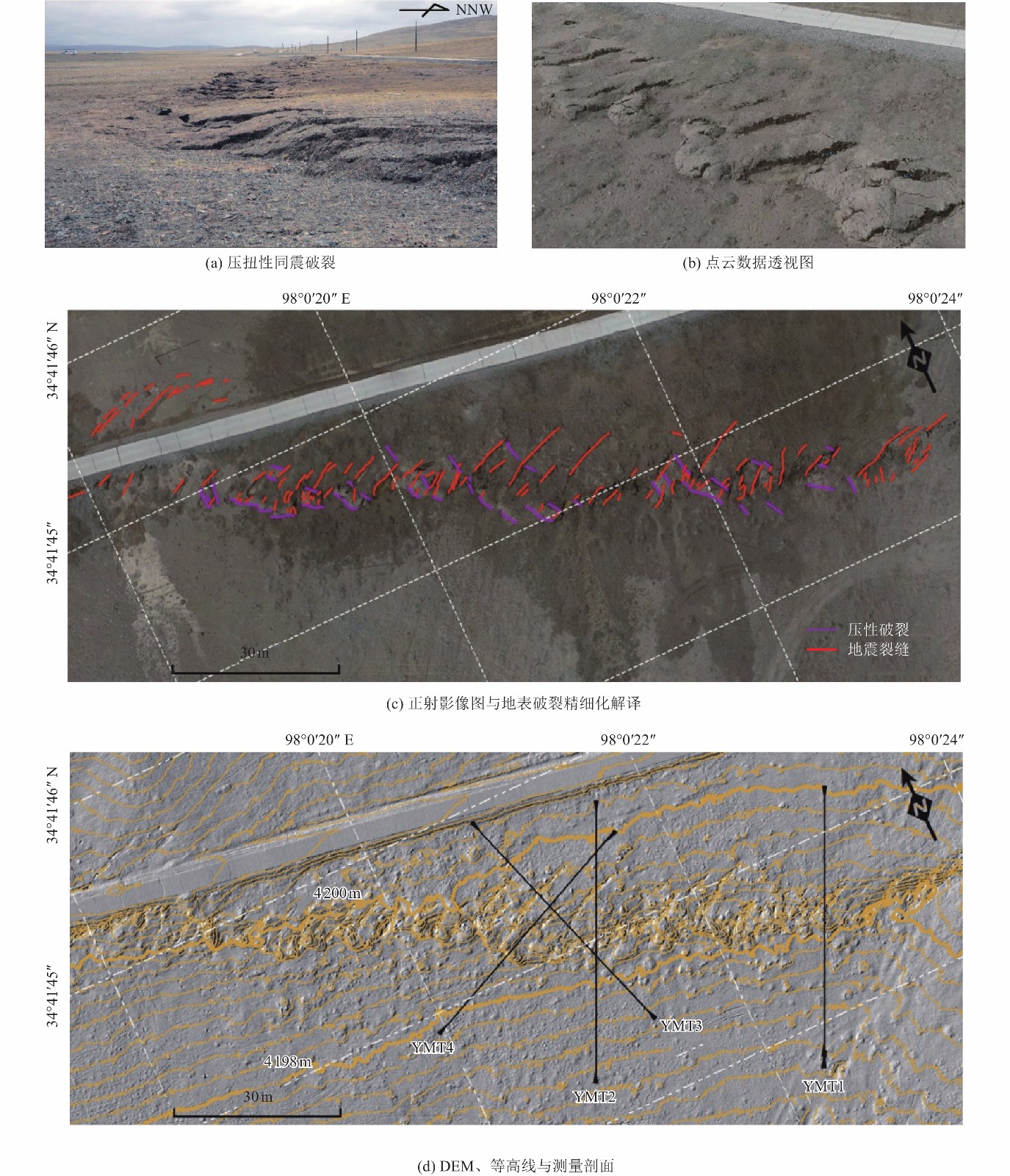
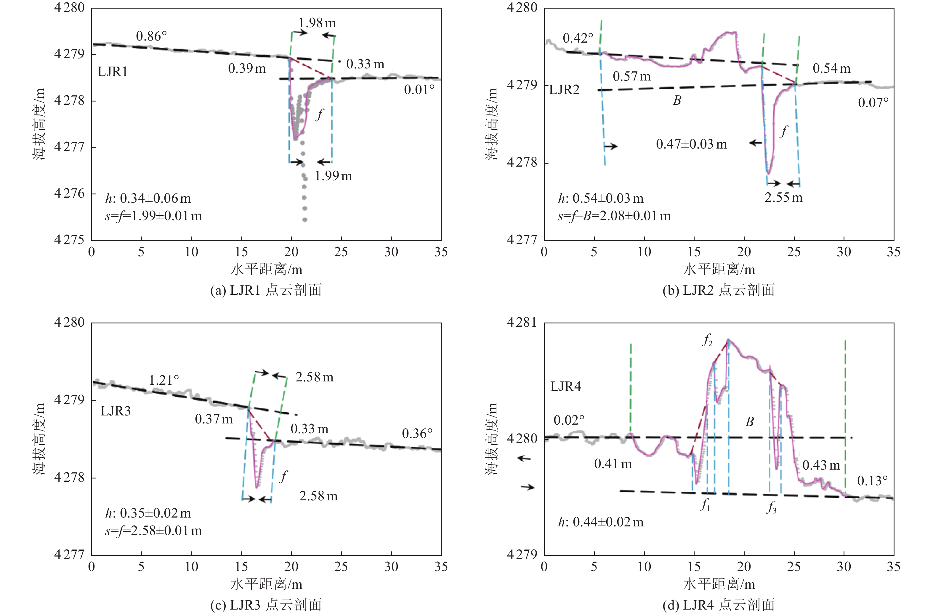
摘要: 2021年5月22日青海玛多发生MS7.4地震,震源断层错动在地表形成了长达160 km的同震地表破裂。可靠的地震地表破裂带参数是研究震源断层活动机制和评价地震危险性的重要基础。采用无人机倾斜摄影测量技术可以获得高精度的点云数据并产出DOM和DEM数据。通过跨破裂带的地形测量,获取了玛多MS7.4地震同震地表变形的垂直位移、水平缩短量和水平拉张量等参数。测量结果显示,玛多MS7.4地震发震断层在不同破裂段具有不同性质和大小的倾滑分量,其中具有压扭性质的野马滩观测点断层垂直位移为0.69~1.01 m,倾向水平缩短量为0.17~0.41 m,倾滑位移为0.71~1.09 m;具有张扭性质的朗玛加合日段断层垂直位移为0.34~0.54 m,倾向水平拉张量为1.99~2.08 m。Abstract: A MS7.4 earthquake occurred in Maduo, Qinghai, on May 22, 2021. The seismogenic fault produced a 160-km-long surface rupture. Reliable parameters of the co-seismic surface rupture are important data for the study on the fault activity and assessment of seismic hazards. In this paper, we generated point clouds, digital ortho-images (DOM) and digital elevation models (DEM) using oblique photogrammetry by Unmanned Aerial Vehicle (UAV) . Parameters of vertical slip, dip-slip shortening and extension of co-seismic slip of the Maduo MS7.4 earthquake were measured from the offset landforms. The results show that the seismogenic fault of the Maduo MS7.4 earthquake is a strike-slip fault with dip-slip in different sections. At the site Yematan, the vertical displacement is 0.69~1.01 m, the dip-slip shortening is 0.17~0.41 m, and the total dip-slip is 0.71~1.09 m. At the site Langma Gaheri, the vertical slip is0.34~0.54 m, and the dip-slip extension is 1.99~2.08 m.
-
Key words:
- Maduo earthquake /
- 3D point cloud /
- UAV oblique photogrammetry /
- Co-seismic dip-slip
-

图 1 2021年玛多MS7.4地震地表破裂展布
Figure 1. Surface rupture zone of the 2021 Maduo MS7.4 earthquake
表 1 观测点无人机航空摄影参数与建模误差
Table 1. UAV aerial photography parameters and modeling errors for two observation sites
观测点 航高/m 面积/km2 地面分辨率/cm 水平误差/cm 垂直误差/cm 点云密度/(个/m2) 朗玛加合日 151 0.48 1.80 0.9 0.9 769 野马滩西 139 0.45 1.67 0.8 1.1 893  下载: 导出CSV
-
[1] 陈桂华, 徐锡伟, 于贵华等, 2009.2008年汶川MS8.0地震多断裂破裂的近地表同震滑移及滑移分解. 地球物理学报, 52(5): 1384—1394 doi: 10.3969/j.issn.0001-5733.2009.05.028Chen G. H. , Xu X. W. , Yu G. H. , et al. , 2009. Co-seismic slip and slip partitioning of multi-faults during the MS8.0 2008 Wenchuan earthquake. Chinese Journal of Geophysics, 52(5): 1384—1394. (in Chinese) doi: 10.3969/j.issn.0001-5733.2009.05.028 [2] 高伟, 何宏林, 邹俊杰等, 2017. 三维图像建模在古地震探槽研究中的应用. 地震地质, 39(1): 172—182 doi: 10.3969/j.issn.0253-4967.2017.01.013Gao W. , He H. L. , Zou J. J. , et al. , 2017. The application of image-based modeling in paleoearthquake trench study. Seismology and Geology, 39(1): 172—182. (in Chinese) doi: 10.3969/j.issn.0253-4967.2017.01.013 [3] 华俊, 赵德政, 单新建等, 2021.2021年青海玛多MW7.3地震InSAR的同震形变场、断层滑动分布及其对周边区域的应力扰动. 地震地质, 43(3): 677—691 doi: 10.3969/j.issn.0253-4967.2021.03.013Hua J. , Zhao D. Z. , Shan X. J. , et al. , 2021. Coseismic deformation field, slip distribution and Coulomb stress disturbance of the 2021 MW7.3 Maduo earthquake using sentinel-1 InSAR observations. Seismology and Geology, 43(3): 677—691. (in Chinese) doi: 10.3969/j.issn.0253-4967.2021.03.013 [4] 荆帅军, 帅向华, 甄盟, 2019. 基于无人机倾斜影像的三维建筑物震害精细信息提取. 地震学报, 41(3): 366—376Jing S. J. , Shuai X. H. , Zhen M. , 2019. Fine information extraction of 3D building seismic damage based on unmanned aerial vehicle oblique images. Acta Seismologica Sinica, 41(3): 366—376. (in Chinese) [5] 李智敏, 李文巧, 李涛等, 2021.2021年5月22日青海玛多MS7.4地震的发震构造和地表破裂初步调查. 地震地质, 43(3): 722—737 doi: 10.3969/j.issn.0253-4967.2021.03.016Li Z. M. , Li W. Q. , Li T. , et al. , 2021. Seismogenic fault and coseismic surface deformation of the Maduo MS7.4 earthquake in Qinghai, China: a quick report. Seismology and Geology, 43(3): 722—737. (in Chinese) doi: 10.3969/j.issn.0253-4967.2021.03.016 [6] 刘超, 雷启云, 余思汗等, 2021. 基于无人机摄影测量技术的地震地表破裂带定量参数提取——以1709年中卫南M7½地震为例. 地震学报, 43(1): 113—123 doi: 10.11939/jass.20200039Liu C. , Lei Q. Y. , Yu S. H. , et al. , 2021. Using UAV photogrammetry technology to extract the quantitative parameters of earthquake surface rupture zone: a case study of the southern Zhongwei M7½ earthquake in 1709. Acta Seismologica Sinica, 43(1): 113—123. (in Chinese) doi: 10.11939/jass.20200039 [7] 潘家伟, 白明坤, 李超等, 2021. 2021年5月22日青海玛多MS7.4地震地表破裂带及发震构造. 地质学报, 95(6): 1655—1670.Pan J. W. , Bai M. K. , Li C. , et al. , 2021. Coseismic surface rupture and seismogenic structure of the 2021-05-22 Maduo (Qinghai)MS7.4 earthquake. Acta Geologica Sinica, 95(6): 1655−1670. (in Chinese) [8] 石峰, 何宏林, 张英, 2010. 青海玉树MS7.1级地震地表破裂带的遥感影像解译. 震灾防御技术, 5(2): 220—227 doi: 10.3969/j.issn.1673-5722.2010.02.009Shi F. , He H. L. , Zhang Y. , 2010. Remote sensing interpretation of the MS7.1 Yushu earthquake surface ruptures. Technology for Earthquake Disaster Prevention, 5(2): 220—227. (in Chinese) doi: 10.3969/j.issn.1673-5722.2010.02.009 [9] 王未来, 房立华, 吴建平等, 2021. 2021年青海玛多MS7.4地震序列精定位研究. 中国科学: 地球科学, 51(7): 1193—1202.Wang W. L. , Fang L. H. , Wu J. P. , et al. , 2021. Aftershock sequence relocation of the 2021 MS7.4 Maduo earthquake, Qinghai, China. Science China Earth Sciences, 64(8): 1371—1380 (in Chinese) [10] 魏占玉, 何宏林, 高伟等, 2014. 基于LiDAR数据开展活动断层填图的实验研究——以新疆独山子背斜-逆冲断裂带为例. 地震地质, 36(3): 794—813 doi: 10.3969/j.issn.0253-4967.2014.03.019Wei Z. Y. , He H. L. , Gao W. , et al. , 2014. Experimental study on geologic mapping of active tectonics based on LiDAR data—a case of Dushanzi anticline-reverse fault zone in Xinjiang. Seismology and Geology, 36(3): 794—813. (in Chinese) doi: 10.3969/j.issn.0253-4967.2014.03.019 [11] 徐锡伟, 陈桂华, 于贵华等, 2010.5·12汶川地震地表破裂基本参数的再论证及其构造内涵分析. 地球物理学报, 53(10): 2321—2336 doi: 10.3969/j.issn.0001-5733.2010.10.006Xu X. W. , Chen G. H. , Yu G. H. , et al. , 2010. Reevaluation of surface rupture parameters of the 5·12 Wenchuan earthquake and its tectonic implication for Tibetan uplift. Chinese Journal of Geophysics, 53(10): 2321—2336. (in Chinese) doi: 10.3969/j.issn.0001-5733.2010.10.006 [12] 于贵华, 徐锡伟, Klinger Y. 等, 2010. 汶川MW7.9级地震同震断层陡坎类型与级联破裂模型. 地学前缘, 17(5): 1—18Yu G. H. , Xu X. W. , Klinger Y. , et al. , 2010. Earthquake fault scarps and cascading-rupture model for the Wenchuan earthquake. Earth Science Frontiers, 17(5): 1—18. (in Chinese) [13] 曾洵, 陈桂华, 黄雄南等, 2019. 天全-荥经断裂晚第四纪活动的地貌证据. 震灾防御技术, 14(3): 652—661 doi: 10.11899/zzfy20190317Zeng X. , Chen G. H. , Huang X. N. , et al. , 2019. Activity of the Tianquan-Yingjing fault in late quaternary-evidence from geomorpgology. Technology for Earthquake Disaster Prevention, 14(3): 652—661. (in Chinese) doi: 10.11899/zzfy20190317 [14] 张建勇, 王新, 陈凌等. 2022. 基于余震重定位和震源机制解研究青海玛多MS7.4地震序列的发震构造和断裂形态. 地球物理学报, 65(2): 552—562Zhang J. Y., Wang X., Chen L., et al., 2022. Seismotectonics and fault geometries of the Qinghai Madoi MS7.4 earthquake sequence:Insight from aftershock relocations and focal mechanism solutions.Chinese Journal of Geophysics,65(2):552—562.(in Chinese) [15] 张喆, 许力生, 2021.2021年青海玛多MW7.5地震矩心矩张量解. 地震学报, 43(3): 387—391 doi: 10.11939/jass.20210079Zhang Z. , Xu L. S. , 2021. The centroid moment tensor solution of the 2021 MW7.5 Maduo, Qinghai, earthquake. Acta Seismologica Sinica, 43(3): 387—391. (in Chinese) doi: 10.11939/jass.20210079 [16] 张志文, 任俊杰, 章小龙, 2021. 高精度无人机航测在2021年玛多7.4级地震地表破裂精细研究中的应用. 震灾防御技术, 16(3): 437—447Zhang Z. W. , Ren J. J. , Zhang X. L. , et al. , 2021. Application of high-precision UAV aerial survey in the detailed study of surface rupture of Maduo MS7.4 earthquake in 2021. Technology for Earthquake Disaster Prevention, 16(3): 437—447. (in Chinese) [17] Anderson E. M., 1951. The dynamics of faulting. 2nd ed. Edinburgh: Oliver and Boyd. [18] Brooks B. A. , Minson S. E. , Glennie C. L. , et al. , 2017. Buried shallow fault slip from the South Napa earthquake revealed by near-field geodesy. Science Advances, 3(7): e1700525. doi: 10.1126/sciadv.1700525 [19] Chen H. , Qu C. Y. , Zhao D. Z. , et al. , 2021. Rupture kinematics and coseismic slip model of the 2021 MW7.3 Maduo (China) earthquake: Implications for the seismic hazard of the Kunlun fault. Remote Sensing, 13(16): 3327. doi: 10.3390/rs13163327 [20] He K. F. , Wen Y. M. , Xu C. J. , et al. , 2022. Fault geometry and slip distribution of the 2021 MW7.4 Maduo, China, earthquake inferred from InSAR measurements and relocated aftershocks. Seismological Research Letters, 93(1): 8—20. doi: 10.1785/0220210204 [21] Howell A. , Nissen E. , Stahl T. , et al. , 2020. Three-dimensional surface displacements during the 2016 MW7.8 Kaikōura earthquake (New Zealand) from photogrammetry-derived point clouds. Journal of Geophysical Research: Solid Earth, 125(1): e2019JB018739. [22] Jin Z. Y. , Fialko Y. , 2021. Coseismic and early postseismic deformation due to the 2021 M7.4 Maduo (China) earthquake. Geophysical Research Letters, 48(21): e2021GL095213. [23] Klinger Y. , Michel R. , King G. C. P. , 2006. Evidence for an earthquake barrier model from MW∼7.8 Kokoxili (Tibet) earthquake slip-distribution. Earth and Planetary Science Letters, 242(3—4): 354—364. doi: 10.1016/j.jpgl.2005.12.003 [24] Koehler R. D. , Dee S. , Elliott A. , et al. , 2021. Field response and surface-rupture characteristics of the 2020 M6.5 Monte Cristo range earthquake, Central Walker Lane, Nevada. Seismological Research Letters, 92(2A): 823—839. doi: 10.1785/0220200371 [25] Kozacı Ö. , Madugo C. M. , Bachhuber J. L. , et al. , 2021. Rapid postearthquake field reconnaissance, paleoseismic trenching, and GIS-based fault slip variability measurements along the MW6.4 and MW7.1 Ridgecrest earthquake sequence, Southern California. Bulletin of the Seismological Society of America, 111(5): 2334—2357. doi: 10.1785/0120200262 [26] Little T. A. , Morris P. , Hill M. P. , et al. , 2021. Coseismic deformation of the ground during large-slip strike-slip ruptures: finite evolution of “mole tracks”. Geosphere, 17(4): 1170—1192. doi: 10.1130/GES02336.1 [27] Padilla A. M. R. , Quintana M. A. , Prado R. M. , et al. , 2022. Near-field high-resolution maps of the Ridgecrest earthquakes from aerial imagery. Seismological Research Letters, 93(1): 494—499. doi: 10.1785/0220210234 [28] Ren J. J. , Zhang Z. W. , Gai H. L. , et al. , 2021. Typical Riedel shear structures of the coseismic surface rupture zone produced by the 2021 MW7.3 Maduo earthquake, Qinghai, China, and the implications for seismic hazards in the block interior. Natural Hazards Research, 1(4): 145—152. doi: 10.1016/j.nhres.2021.10.001 [29] Wei Z. Y. , He H. L. , Lei Q. Y. , et al. , 2021. Constraining coseismic earthquake slip using Structure from Motion from fault scarp mapping (East Helanshan Fault, China). Geomorphology, 375: 107552. doi: 10.1016/j.geomorph.2020.107552 [30] Xu X. W. , Yu G. H. , Klinger Y. , et al. , 2006. Reevaluation of surface rupture parameters and faulting segmentation of the 2001 Kunlunshan earthquake (MW7.8), northern Tibetan Plateau, China. Journal of Geophysical Research: Solid Earth, 111(B5): B05316. -


 点击查看大图
图(6) / 表(1)
计量
- 文章访问数: 336
- HTML全文浏览量: 167
- PDF下载量: 26
- 被引次数: 0
