
Late Quaternary Tectonic Deformation of the Latgan Fold in the Southern Margin of the Bole Basin, North Tianshan
-
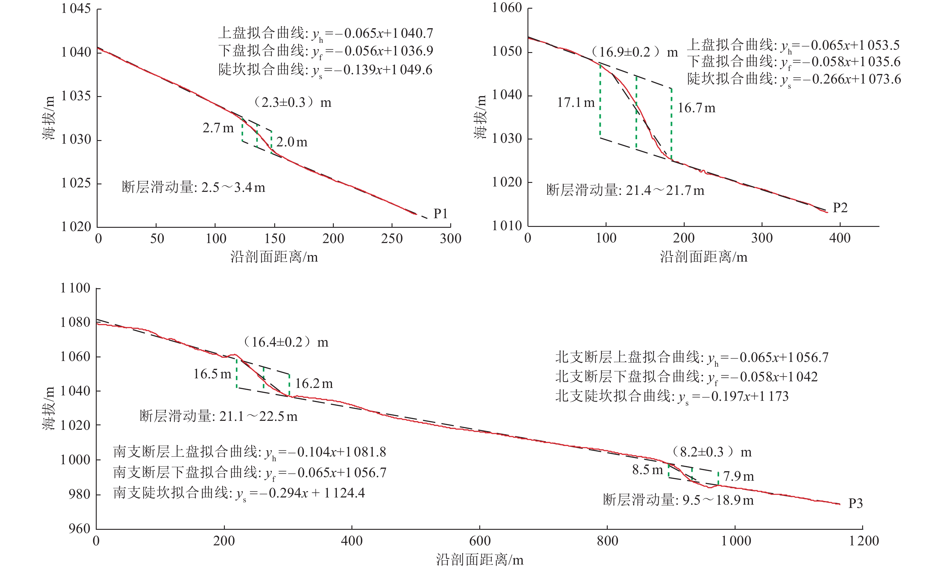
摘要: 研究天山地区活动逆冲断裂、褶皱对于认识整个天山再生造山带的隆升和地震危险性评估具有重要意义。以天山北麓博乐盆地南缘库松木楔克断裂东段勒塔干褶皱为研究对象,通过无人机航拍提取高精度DEM和野外实地调查结果,将勒塔干背斜东部迪里克河附近的洪积扇分为5期,从新到老分别为T1、T2、T3、T4、T5。其中,T4洪积扇完整记录了褶皱的变形历史,其后翼褶皱陡坎高度为(8.1±0.6)m。自T4洪积扇废弃以来,勒塔干断层的滑移量为(33.0±2.6)m。T3洪积扇仅发育在迪里克河出水口处,即勒塔干背斜北侧,(16.9±0.2)m的断层陡坎高度揭示了自T3洪积扇废弃以来,控制背斜形成的逆断层发生了21.4~21.7 m的滑动。通过与相邻地区洪积扇期次进行对比,认为T4洪积扇的废弃年龄为(74.01±6.14)ka,勒塔干背斜下断坡晚第四纪滑动速率为(0.45±0.05)mm/a,勒塔干褶皱晚第四纪地壳缩短速率为(0.37±0.04)mm/a。Abstract: The study of active thrust faults and thrust folds in the Tianshan ranges is of great significance for understanding the uplift characteristic and earthquake hazard for the Tianshan. This paper focuses on the Latgan fold in the eastern segment of the Kusongmuxieke fault on the southern margin of the Bole Basin in the North Tianshan. Based on the high-precision DEM extracted by drone aerial photography and field surveys, we divided the alluvial fans which developed along the Dilik River in the eastern part of the Latgan fold into five generations, T1-T5 from young to old. The alluvial fan T4 completely records the deformation history of the fold. The height of the fold scarp of T4 is 8.1±0.6 m. Since the abandonment of the T4 alluvial fan, the dip-slip offset of the Latgan fault is 33.0±2.6 m. The T3 alluvial fan is only developed at the outlet of the Dilik River, that is, on the north side of the Latgan anticline. The 21.4-21.7 m dip-slip offset can be derived from the 16.9±0.2 m fault scarp since the T3 alluvial fan was abandoned. By comparing with the alluvial fan in adjacent areas, we can determine the abandoned ages of the T4 alluvial fan is 74.01±6.14 ka. Based on the lower dip-slip offset and T4 alluvial fan abandonment ages, the late Quaternary slip rate of the Latgan anticline and crustal shorting are 0.45±0.05 mm/a and 0.37±0.04 mm/a, respectively.
-
Key words:
- Activity fold /
- Tianshan northern piedmont /
- Bole basin /
- Latgan anticline /
- Tectonic deformation
-

图 2 博乐盆地和库松木楔克东段断层展布图
Figure 2. Fault distribution of Bole basin and eastern segment of Kusongmuxieke fault

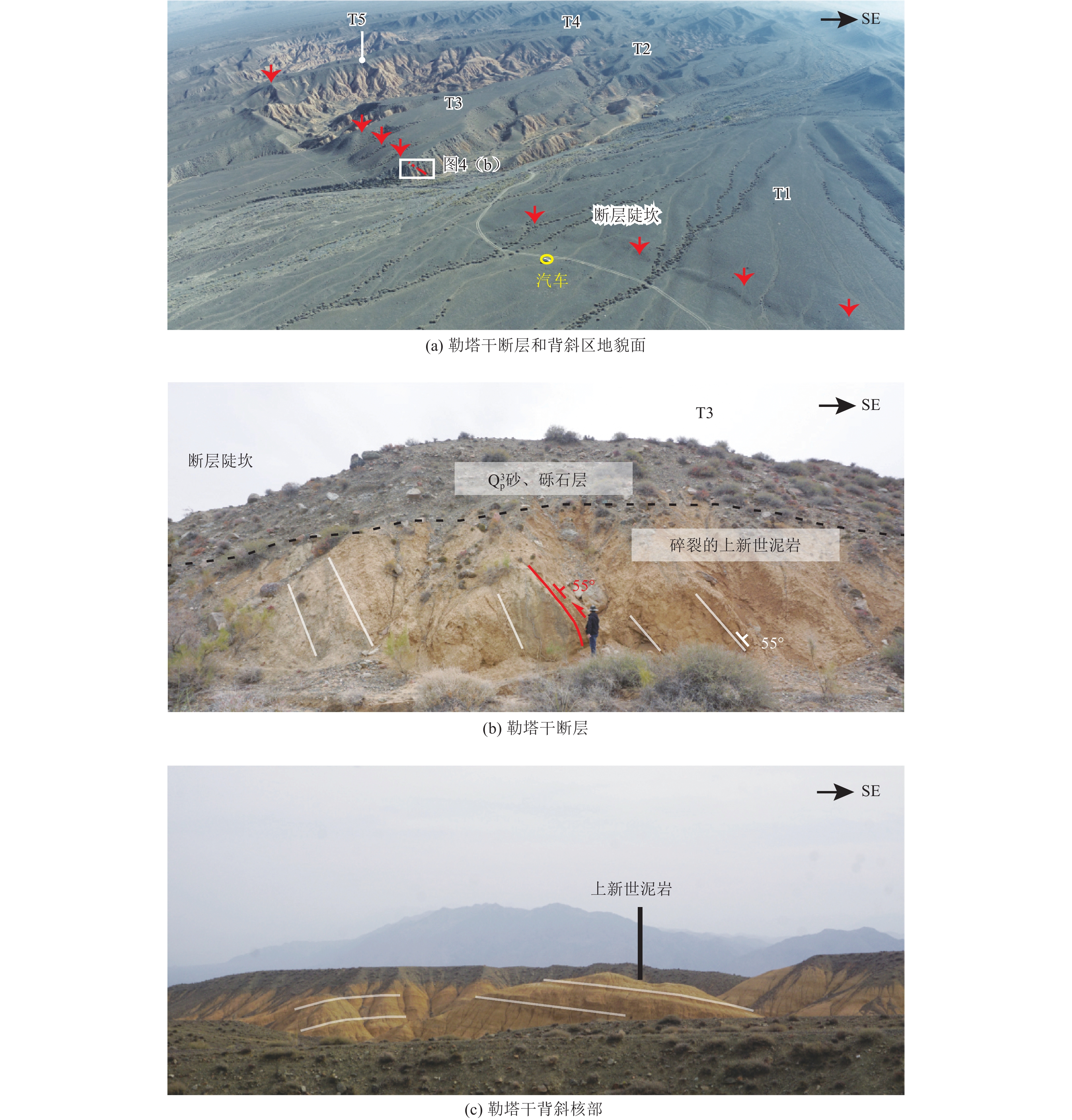
图 3 勒塔干背斜东段洪积扇分布
Figure 3. Alluvial fans distributions in the eastern segment of Latgan anticline

图 5 勒塔干褶皱东段地貌剖面图和断弯褶皱、铲状断层后翼抬升动力学模型图
Figure 5. Geomorphic profile of eastern segment of Latgan fold and back limb uplift dynamic model of fault-bend fold and listric fault
-
[1] 陈建波, 沈军, 李军, 等, 2007. 北天山西段库松木楔克山山前断层新活动特征初探. 西北地震学报, 29(4): 335—340Chen J. B. , Shen J. , Li J. , et al. , 2007. Preliminary study on new active characteristics of Kusongmuxieke Mountain front fault in the West Segment of North Tianshan. Northwestern Seismological Journal, 29(4): 335—340. (in Chinese) [2] 邓起东, 冯先岳, 张培震等, 2000. 天山活动构造. 北京: 地震出版社. [3] 沈军, 吴传勇, 陈建波, 2008. 新疆主要逆断层-褶皱构造区基本地震构造特征与潜在震源划分问题. 震灾防御技术, 3(2): 101—110 doi: 10.3969/j.issn.1673-5722.2008.02.001Shen J. , Wu C. Y. , Chen J. B. , 2008. Basic features of the Major thrust Fault-Fold tectonics and determination of potential earthquake source in Xinjiang. Technology for Earthquake Disaster Prevention, 3(2): 101—110 (in Chinese). doi: 10.3969/j.issn.1673-5722.2008.02.001 [4] 杨晓平, 冉洪流, 2010. 活动推覆构造区潜在震源的边界和震级上限——以1902年阿图什8¼级地震构造区为例. 震灾防御技术, 5(2): 145—156 doi: 10.3969/j.issn.1673-5722.2010.02.001Yang X. P. , Ran H. L. , 2010. The boundary and upper limit magnitude of potential seismic source zone in active nappe structure region——an example from M8¼ Atushi seismic structure region. Technology for Earthquake Disaster Prevention, 5(2): 145—156 (in Chinese). doi: 10.3969/j.issn.1673-5722.2010.02.001 [5] 张培震, 邓起东, 杨晓平等, 1996. 天山的晚新生代构造变形及其地球动力学问题. 中国地震, 12(2): 127—140Zhang P. Z. , Deng Q. D. , Yang X. P. , et al. , 1996. Late Cenozoic tectonic deformation and mechanism along the Tianshan mountain, northwestern China. Earthquake Research in China, 12(2): 127—140 (in Chinese). [6] Abdrakhmatov K. Y. , Aldazhanov S. A. , Hager, B. H. , et al. , 1996. Relatively recent construction of the Tien Shan inferred from GPS measurements of present-day crustal deformation rates. Nature, 384(6608): 450—453. doi: 10.1038/384450a0 [7] Allen M. B. , Vincent S. J. , Wheeler P. J. , 1999. Late Cenozoic tectonics of the Kepingtage thrust zone: interactions of the Tien Shan and Tarim Basin, northwest China. Tectonics, 18(4): 639—654. doi: 10.1029/1999TC900019 [8] Avouac J. P. , Tapponnier P. , 1993. Kinematic model of active deformation in central Asia. Geophysical Research Letters, 20(10): 895—898. doi: 10.1029/93GL00128 [9] Burchfiel B. C. , Brown E. T. , Deng Q. D. , et al. , 1999. Crustal shortening on the margins of the Tien Shan, Xinjiang, China. International Geology Review, 41(8): 665—700. doi: 10.1080/00206819909465164 [10] Campbell G. E. , Walker R. T. , Abdrakhmatov K. , et al. , 2013. The Dzhungarian fault: late quaternary tectonics and slip rate of a major right-lateral strike-slip fault in the northern Tien Shan region. Journal of Geophysical Research: Solid Earth, 118(10): 5681—5698. doi: 10.1002/jgrb.50367 [11] Charreau J. , Avouac J. P. , Chen Y. , et al. , 2008. Miocene to present kinematics of fault-bend folding across the Huerguosi anticline, northern Tianshan (China), derived from structural, seismic, and magnetostratigraphic data. Geology, 36(11): 871—874. doi: 10.1130/G25073A.1 [12] Charreau J. , Saint-Carlier D. , Dominguez S. , et al. , 2017. Denudation outpaced by crustal thickening in the eastern Tianshan. Earth and Planetary Science Letters, 479: 179—191. doi: 10.1016/j.jpgl.2017.09.025 [13] Charreau J. , Sartégou A. , Saint-Carlier D. , et al. , 2020. Late Miocene to quaternary slip history across the Qiulitag anticline in the southern Tianshan piedmont. Terra Nova, 32(1): 89—96. doi: 10.1111/ter.12439 [14] Ghose S. , Hamburger M. W. , Ammon C. J. , 1998. Source parameters of moderate-sized earthquakes in the Tien Shan, central Asia from regional moment tensor inversion. Geophysical Research Letters, 25(16): 3181—3184. doi: 10.1029/98GL02362 [15] Gong W. Y. , Zhang Y. F. , Li T. , et al. , 2019. Multi-sensor geodetic observations and modeling of the 2017 MW 6.3 Jinghe earthquake. Remote Sensing, 11(18): 2157. doi: 10.3390/rs11182157 [16] Grützner C. , Walker R. T. , Abdrakhmatov K. E. , et al. , 2017. Active tectonics around Almaty and along the Zailisky Alatau rangefront. Tectonics, 36(10): 2192—2226. doi: 10.1002/2017TC004657 [17] Hendrix M. S. , Dumitru T. A. , Graham S. A. , 1994. Late Oligocene-early Miocene unroofing in the Chinese Tian Shan: an early effect of the India-Asia collision. Geology, 22(6): 487—490. doi: 10.1130/0091-7613(1994)022<0487:LOEMUI>2.3.CO;2 [18] Hu X. F. , Pan B. T. , Kirby E. , et al. , 2015. Rates and kinematics of active shortening along the eastern Qilian Shan, China, inferred from deformed fluvial terraces. Tectonics, 34(12): 2478—2493. doi: 10.1002/2015TC003978 [19] Hu Z. K. , Yang X. P. , Yang H. B. , et al. , 2021. Slip rate and Paleoseismology of the Bolokenu-Aqikekuduk (Dzhungarian) right-lateral strike-slip fault in the Northern Tian Shan, NW China. Tectonics, 40(8): e2020TC006604. [20] Huang W. L. , Yang X. P. , Li A. , et al. , 2015. Late Pleistocene shortening rate on the northern margin of the Yanqi Basin, southeastern Tian Shan, NW China. Journal of Asian Earth Sciences, 112: 11—24. doi: 10.1016/j.jseaes.2015.08.024 [21] Huang W. L. , Yang X. P. , Jobe J. A. T. , et al. , 2019. Alluvial plains formation in response to 100-ka glacial–interglacial cycles since the Middle Pleistocene in the southern Tian Shan, NW China. Geomorphology, 341: 86—101. doi: 10.1016/j.geomorph.2019.05.013 [22] Hubert-Ferrari A. , Suppe J. , Gonzalez-Mieres R. , et al. , 2007. Mechanisms of active folding of the landscape (southern Tian Shan, China). Journal of Geophysical Research: Solid Earth, 112(B3): B03S09. [23] Lavé J. , Avouac J. P. , 2000. Active folding of fluvial terraces across the Siwaliks Hills, Himalayas of central Nepal. Journal of Geophysical Research: Solid Earth, 105(B3): 5735—5770. doi: 10.1029/1999JB900292 [24] Makarov V. I. , Alekseev D. V. , Batalev V. Y. , et al. , 2010. Underthrusting of Tarim beneath the Tien Shan and deep structure of their junction zone: main results of seismic experiment along MANAS Profile Kashgar-Song-Köl. Geotectonics, 44(2): 102—126. doi: 10.1134/S0016852110020020 [25] Molnar P. , Tapponnier P. , 1975. Cenozoic tectonics of Asia: effects of a continental collision: features of recent continental tectonics in Asia can be interpreted as results of the India-Eurasia collision. Science, 189(4201): 419—426. doi: 10.1126/science.189.4201.419 [26] Molnar P. , Deng Q. D. , 1984. Faulting associated with large earthquakes and the average rate of deformation in central and eastern Asia. Journal of Geophysical Research: Solid Earth, 89(B7): 6203—6227. doi: 10.1029/JB089iB07p06203 [27] Ren G. X. , Li C. Y. , Wu C. Y. , et al. , 2021. Late Quaternary slip rate and kinematics of the Baoertu fault, constrained by 10Be exposure ages of displaced surfaces within eastern Tian Shan. Lithosphere, 2021(1): 7866920. doi: 10.2113/2021/7866920 [28] Rizza M. , Abdrakhmatov K. , Walker R. , et al. , 2019. Rate of slip from multiple Quaternary dating methods and paleoseismic investigations along the Talas-Fergana Fault: tectonic implications for the Tien Shan Range. Tectonics, 38(7): 2477—2505. doi: 10.1029/2018TC005188 [29] Saint-Carlier D. , Charreau J. , Lavé J. , et al. , 2016. Major temporal variations in shortening rate absorbed along a large active fold of the southeastern Tianshan piedmont (China). Earth and Planetary Science Letters, 434: 333—348. doi: 10.1016/j.jpgl.2015.11.041 [30] Stockmeyer J. M., Shaw J. H., Guan S. W., 2014. Seismic hazards of multisegment thrust-fault ruptures: insights from the 1906 MW 7.4-8.2 Manas, China, earthquake. Seismological Research Letters, 85(4): 801—808. Stockmeyer J. M., Shaw J. H., Brown N. D., et al., 2017. Active thrust sheet deformation over multiple rupture cycles: a quantitative basis for relating terrace folds to fault slip rates. GSA Bulletin, 129(9—10): 1337—1356. [31] Sun J. M. , Zhu R. X. , Bowler J. , 2004. Timing of the Tianshan Mountains uplift constrained by magnetostratigraphic analysis of molasse deposits. Earth and Planetary Science Letters, 219(3—4): 239—253. doi: 10.1016/S0012-821X(04)00008-1 [32] Sun J. M. , Zhang Z. Q. , 2009. Syntectonic growth strata and implications for late Cenozoic tectonic uplift in the northern Tian Shan, China. Tectonophysics, 463(1—4): 60—68. doi: 10.1016/j.tecto.2008.09.008 [33] Tapponnier P. , Molnar P. , 1979. Active faulting and Cenozoic tectonics of the Tien Shan, Mongolia, and Baykal regions. Journal of Geophysical Research: Solid Earth, 84(B7): 3425—3459. doi: 10.1029/JB084iB07p03425 [34] Thompson S. C. , Weldon R. J. , Rubin C. M. , et al. , 2002. Late Quaternary slip rates across the central Tien Shan, Kyrgyzstan, central Asia. Journal of Geophysical Research: Solid Earth, 107(B9): 2203. [35] Wang M. , Shen Z. K. , 2020a. Present-day crustal deformation of continental China derived from GPS and its tectonic implications. Journal of Geophysical Research: Solid Earth, 125(2): e2019JB018774. [36] Wang S. Y. , Jiao R. H. , Ren Z. K. , et al. , 2020b. Active thrusting in an intermontane basin: the Kumysh Fault, eastern Tian Shan. Tectonics, 39(8): e2019TC006029. [37] Wu C. Y. , Ren G. X. , Yu J. X. , et al. , 2020. Oblique right-lateral faulting along the Northern Margin of the Ili Basin in the Northern Tian Shan, Northwest China. Tectonics, 39(10): e2020TC006061. [38] Yang S. M. , Li J. , Wang Q. , 2008. The deformation pattern and fault rate in the Tianshan Mountains inferred from GPS observations. Science in China Series D: Earth Sciences, 51(8): 1064—1080. doi: 10.1007/s11430-008-0090-8 [39] Yin A. , Nie S. , Craig P. , et al. , 1998. Late Cenozoic tectonic evolution of the southern Chinese Tian Shan. Tectonics, 17(1): 1—27. doi: 10.1029/97TC03140 [40] Zhang Z. L. , Sun J. M. , Lü L. X. , et al. , 2018. Neogene paleomagnetic study of the western Baicheng Depression: implications for the intensified deformation of Tian Shan since the latest Miocene. Journal of Geophysical Research: Solid Earth, 123(12): 10349—10369. [41] Zhong Y. Z. , Xiong J. G. , Li Y. L. , et al. , 2020. Constraining Late Quaternary crustal shortening in the eastern Qilian Shan from deformed river terraces. Journal of Geophysical Research: Solid Earth, 125(9): e2020JB020631. [42] Zubovich A. V. , Wang X. Q. , Scherba Y. G. , et al. , 2010. GPS velocity field for the Tien Shan and surrounding regions. Tectonics, 29(6): TC6014. -

 下载:
下载:
 点击查看大图

图(6)
计量
- 文章访问数: 254
- HTML全文浏览量: 108
- PDF下载量: 50
- 被引次数: 0
