
Geomorphic Characteristics of Tectonic Activity of Tanglang-Yimen Fault in Central Yunnan
-
摘要: 汤郎-易门断裂位于青藏高原东南缘,走向近南北,按地貌特征及区域构造背景可将其划分为北段(营盘村-插甸断裂)、中段(插甸-碧城断裂)及南段(碧城-易门断裂)。针对汤郎-易门断裂构造地貌差异,利用30 m分辨率的DEM数据,基于GIS技术提取与断裂活动相关的水系,并计算其陡峭指数,结合野外考察及遥感影像讨论断裂在不同分段的活动习性与地貌特征。研究发现,区域内降水及基岩抗风化能力对亚流域陡峭指数的影响较小,认为陡峭指数能够较好地反映汤郎-易门断裂的垂直构造运动。陡峭指数显示,断裂走向呈两端高、中间低的特点,其分段性与前人划分结果具有较好一致性,所表征的基岩垂直活动性差异可作为断裂带活动分段的依据。断裂带东西侧陡峭指数在不同分段上表现出差异性,北段断裂东西侧陡峭指数显示出东、西向差异性抬升不显著,其与地貌上断裂北段表现的左旋走滑运动一致,以水平运动为主;断裂中段及南段陡峭指数在东西侧表现出东高西低的特点,显示东侧较西侧基岩抬升更快,可能以垂直差异运动为主。Abstract: The Tanglang-Yimen fault on the southeastern margin of the Qinghai-Tibet Plateau is a seismic structure with a close to north-south strike and segmental activity. Tanglang Yimen fault can be divided into north section (yingpancun Chadian fault), middle section (Chadian Bicheng fault) and south section (Bicheng Yimen fault), According to geomorphic features and regional tectonic background.Aiming at the structural geomorphology difference of the Tanglang-Yimen fault, we use DEM data with a resolution of 30 m, based on GIS technology, extract the water system sub-basins that are closely related to the fault and calculate its steepness index. Combined with field surveys, remote sensing images and historical earthquakes, the different faults Segmented activities and geomorphological features are discussed.It is find that the influence of rainfall and weathering resistance of bedrock on the geomorphic index of the sub basin is relatively limited and the geomorphic index can better reflect the vertical tectonic movement of the Tanglang-Yimen fault.The geomorphic index shows that the fault trend is high at both ends and low in the middle, and the segmentation is consistent with the previous results.The vertical movement difference of bedrock shown by geomorphic index can be used as the basis for the activity segmentation of fault. The geomorphic index on the East and west sides of the fault zone are different in different segments. The distribution of geomorphic index (ksn) in the northern part of the fault zone is relatively stable, and the differential uplift of the two sides is not significant.The geomorphological features of the northern section of the Tanglang-Yimen fault are left-lateral strike-slip movement. Blocking ridge, offset ridge and synchronous dislocation are developed in Fawo, laomuba and zhidu areas.The geomorphic index (ksn) in the middle and south part of the fault zone is high in the East and low in the West ,indicating that there is vertical differential movement, and the eastern side uplifted faster than the west side.
-
Key words:
- Wuding earthquake /
- Tanglang-Yimen fault /
- Tectonic activity /
- Steepness index
-

图 1 汤郎-易门断裂几何展布与地震活动分布
注:图中数据来自国家地震科学数据中心,F1表示汤郎-易门断裂,F2表示己衣断裂,F3表示燕子窝断裂,F4表示羊旧关断裂,F5表示东山河断裂,F6表示总官村断裂。 (a) 研究区域构造位置;(b)汤郎-易门断裂北段与中段;(c)汤郎-易门断裂南段
Figure 1. Geometric distribution and seismicity distribution of Tanglang-Yimen fault

图 2 汤郎-易门断裂亚流域分布
(a)断裂及水系分布;(b)沿断裂走向的标准化陡峭指数分布;(c)北段两侧标准化陡峭指数分布;(d)中段两侧标准化陡峭指数分布;(e)南段两侧标准化陡峭指数分布
Figure 2. Distribution of Tanglang-Yimen fault sub watershed
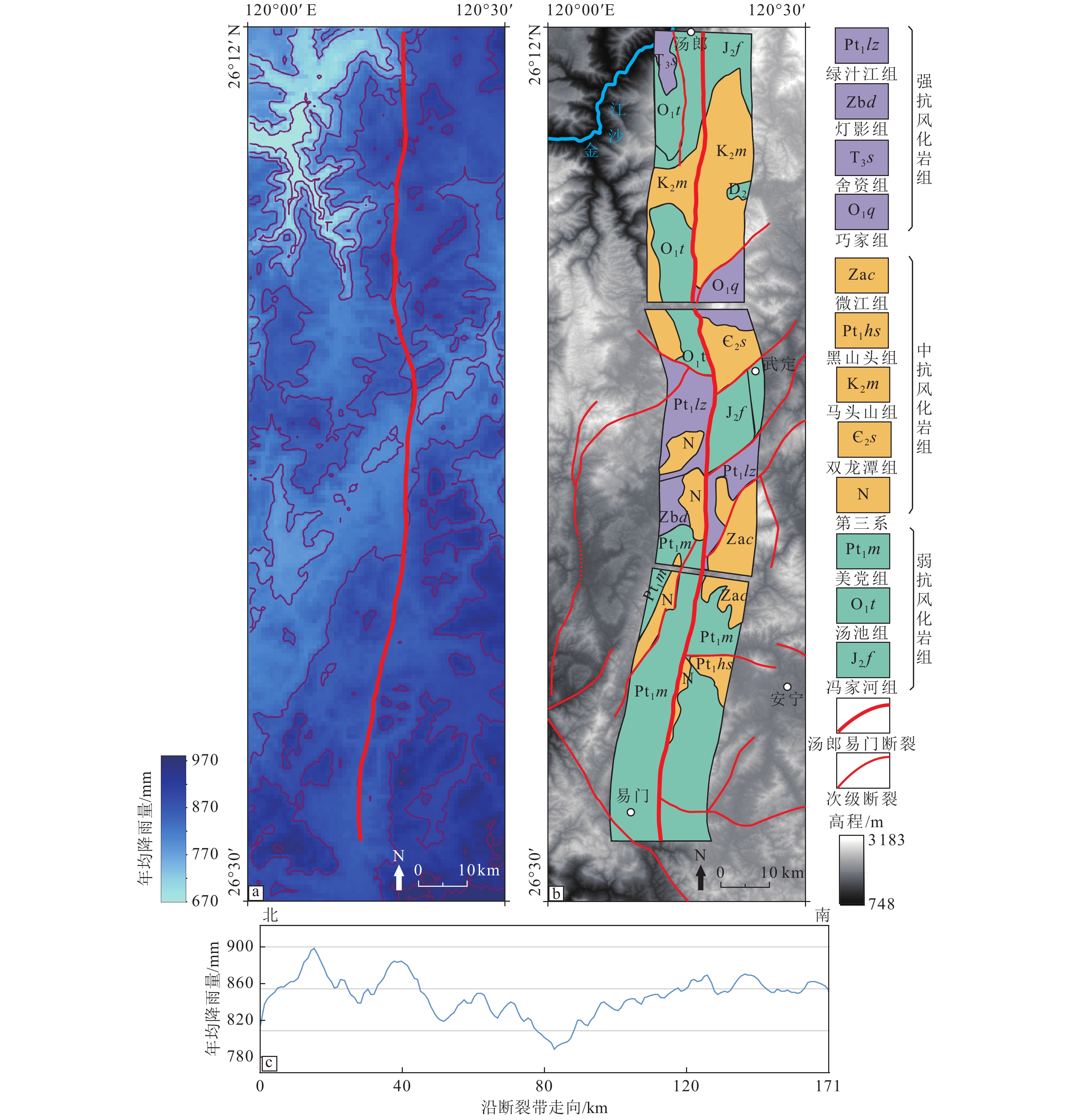
图 3 降雨量及基岩抗风化能力分布
(a)降雨量分布;(b)基岩抗风化能力分布;(c)沿断裂走向的降雨量分布
Figure 3. Rainfall and bedrock distribution
-
[1] 安晓文, 常祖峰, 2018. 云南第四纪活动断裂暨《云南第四纪活动断裂分布图》. 北京: 地震出版社. [2] 陈东风, 巩伦宝, 李振, 2015. 基于不同空间尺度DEM河网提取的阈值选取准则研究. 水资源与水工程学报, 26(2): 109—113 doi: 10.11705/j.issn.1672-643X.2015.02.020Chen D. F. , Gong L. B. , Li Z. , 2015. Study on principle of threshold selection of river network extraction based on different DEM scales. Journal of Water Resources & Water Engineering, 26(2): 109—113. (in Chinese) doi: 10.11705/j.issn.1672-643X.2015.02.020 [3] 刁桂苓, 张四昌, 王绍晋等, 1999.1995年云南武定6.5级地震震源断层的三维特征. 地震学报, 21(4): 361—366 doi: 10.3321/j.issn:0253-3782.1999.04.004Diao G. L. , Zhang S. C. , Wang S. J. , et al. , 1999. Three-dimensional characteristics of focal fault of 1995 MS6.5 wuding earthquake occurring in Yunnan province. Acta Seismologica Sinica, 21(4): 361—366. (in Chinese) doi: 10.3321/j.issn:0253-3782.1999.04.004 [4] 阚荣举, 张四昌, 晏凤桐等, 1977. 我国西南地区现代构造应力场与现代构造活动特征的探讨. 地球物理学报, 20(2): 96—109Kan R. J. , Zhang S. C. , Yan F. T. , et al. , 1977. Present tectonic stress field and its relation to the characteristics of recent tectonic activity in southwestern China. Acta Geophysica Sinica, 20(2): 96—109. (in Chinese) [5] 李白基, 秦嘉政, 钱晓东, 2002.1995年武定6.5级地震余震的S波分裂. 地震研究, 25(2): 108—114 doi: 10.3969/j.issn.1000-0666.2002.02.003Li B. J. , Qin J. Z. , Qian X. D. , 2002. Shear - wave Splitting of the aftershocks for the 1995 Earthquake of Yunnan Wuding. Journal of Seismological Research, 25(2): 108—114. (in Chinese) doi: 10.3969/j.issn.1000-0666.2002.02.003 [6] 李明, 张世民, 姜大伟等, 2019. 龙门山中北段流域地貌特征及其构造意义. 震灾防御技术, 14(3): 640—651 doi: 10.11899/zzfy20190316Li M. , Zhang S. M. , Jiang D. W. , et al. , 2019. Geomorphic features and tectonic significance of the middle and North Section of Longmenshan. Technology for Earthquake Disaster Prevention, 14(3): 640—651. (in Chinese) doi: 10.11899/zzfy20190316 [7] 李玶, 汪良谋, 1975. 云南川西地区地震地质基本特征的探讨. 地质科学, 10(4): 308—326Li P. , Wang L. M. , 1975. Exploration of the seismo-geological features of the Yunnan-west Sichuan region. Chinese Journal of Geology, 10(4): 308—326. (in Chinese) [8] 梁欧博, 任俊杰, 吕延武, 2018. 涪江流域河流地貌特征对虎牙断裂带活动性的响应. 地震地质, 40(1): 42—56 doi: 10.3969/j.issn.0253-4967.2018.01.004Liang O. B. , Ren J. J. , Lü Y. W. , 2018. The response of fluvial geomorphologic characteristics of the Fujiang Drainge Basin to activity of the Huya Fault Zone. Seismology and Geology, 40(1): 42—56. (in Chinese) doi: 10.3969/j.issn.0253-4967.2018.01.004 [9] 罗大游, 温兴平, 沈攀等, 2017. 基于DEM的水系提取及集水阈值确定方法研究. 水土保持通报, 37(4): 189—193Luo D. Y. , Wen X. P. , Shen P. , et al. , 2017. Information extraction of river networks and determination of drainage area threshold using DEM data. Bulletin of Soil and Water Conservation, 37(4): 189—193. (in Chinese) [10] 吕江宁, 沈正康, 王敏, 2003. 川滇地区现代地壳运动速度场和活动块体模型研究. 地震地质, 25(4): 543—554 doi: 10.3969/j.issn.0253-4967.2003.04.003Lü J. N. , Shen Z. K. , Wang M. , 2003. Contemporary crustal deformation and active tectonic block model of the Sichuan-Yunnan region, China. Seismology and Geology, 25(4): 543—554. (in Chinese) doi: 10.3969/j.issn.0253-4967.2003.04.003 [11] 马淑田, 赵薇, 1997. 1995年10月24日云南武定MS6.5地震的震源机制解. 地震学报, 19(3): 241—245. [12] 秦嘉政, 钱晓东, 张俊伟等, 2000. 武定地震序列剪应力场的时空分布特征. 地震学报, 22(1): 8—16 doi: 10.3321/j.issn:0253-3782.2000.01.002Qin J. Z. , Qian X. D. , Zhang J. W. , et al. , 2000. The space and time distribution characteristics of the shear stress field for the sequence of the Wuding earthquake. Acta Seismologica Sinica, 22(1): 8—16. (in Chinese) doi: 10.3321/j.issn:0253-3782.2000.01.002 [13] 宋文, 黄毓珍, 1997. 武定6.5级地震序列震源机制. 地震研究, 20(3): 265—272Song W. , Huang Y. Z. , 1997. The focal mechanism of the Wuding earthquake sequence. Journal of Seismological Research, 20(3): 265—272. (in Chinese) [14] 苏琦, 袁道阳, 谢虹, 2016. 祁连山−河西走廊黑河流域地貌特征及其构造意义. 地震地质, 38(3): 560—581 doi: 10.3969/j.issn.0253-4967.2016.03.005Su Q. , Yuan D. Y. , Xie H. , 2016. Geomorphic features of the Heihe River Drainage Basin in Western Qilian Shan-Hexi corridor and its tectonic implications. Seismology and Geology, 38(3): 560—581. (in Chinese) doi: 10.3969/j.issn.0253-4967.2016.03.005 [15] 云南省地震局综合大队地质队, 1981. 地震地质报告集(一). 昆明: 云南省地震局综合大队地质队. [16] 张会平, 杨农, 张岳桥等, 2006. 岷江水系流域地貌特征及其构造指示意义. 第四纪研究, 26(1): 126−135.Zhang H. P., Yang N., Zhang Y. Q., et al., 2006. Geomorphology of the Minjiang drainage system (Sichuan, China) and its structural implications. Quaternary Sciences, 26(1): 126—135. (in Chinese) [17] Hijmans R. J. , Cameron S. E. , Parra J. L. , et al. , 2005. Very high resolution interpolated climate surfaces for global land areas. International Journal of Climatology, 25(15): 1965—1978. doi: 10.1002/joc.1276 [18] Howard A. D. , Dietrich W. E. , Seidl M. A. , 1994. Modeling fluvial erosion on regional to continental scales. Journal of Geophysical Research: Solid Earth, 99(B7): 13971—13986. doi: 10.1029/94JB00744 [19] Jenson S. K. , Domingue J. O. , 1988. Extracting topographic structure from digital elevation data for geographic information system analysis. Photogrammetric Engineering and Remote Sensing, 54(11): 1593—1600. [20] Kirby E. , Whipple K. , 2001. Quantifying differential rock-uplift rates via stream profile analysis. Geology, 29(5): 415—418. doi: 10.1130/0091-7613(2001)029<0415:QDRURV>2.0.CO;2 [21] Kirby E. , Whipple K. X. , Tang W. Q. , et al. , 2003. Distribution of active rock uplift along the eastern margin of the Tibetan Plateau: inferences from bedrock channel longitudinal profiles. Journal of Geophysical Research: Solid Earth, 108(B4): 2217. [22] O'Callaghan J. F., Mark D. M., 1984. The extraction of drainage networks from digital elevation data. Computer Vision, Graphics, and Image Processing, 27(2): 247. [23] Shen Z. K. , Lü J. N. , Wang M. , et al. , 2005. Contemporary crustal deformation around the southeast borderland of the Tibetan Plateau. Journal of Geophysical Research: Solid Earth, 110(B11): B11409. [24] Whipple K. X. , Tucker G. E. , 1999. Dynamics of the stream-power river incision model: implications for height limits of mountain ranges, landscape response timescales, and research needs. Journal of Geophysical Research: Solid Earth, 104(B8): 17661—17674. doi: 10.1029/1999JB900120 [25] Whipple K. X. , Hancock G. S. , Anderson R. S. , 2000. River incision into bedrock: mechanics and relative efficacy of plucking, abrasion, and cavitation. GSA Bulletin, 112(3): 490—503. doi: 10.1130/0016-7606(2000)112<490:RIIBMA>2.0.CO;2 -

 下载:
下载:

 点击查看大图
计量
- 文章访问数: 375
- HTML全文浏览量: 106
- PDF下载量: 40
- 被引次数: 0
