
The Preliminary Analysis of Airguns Seismic Data in the MS6.2 Taiwan Strait Earthquake Region
-
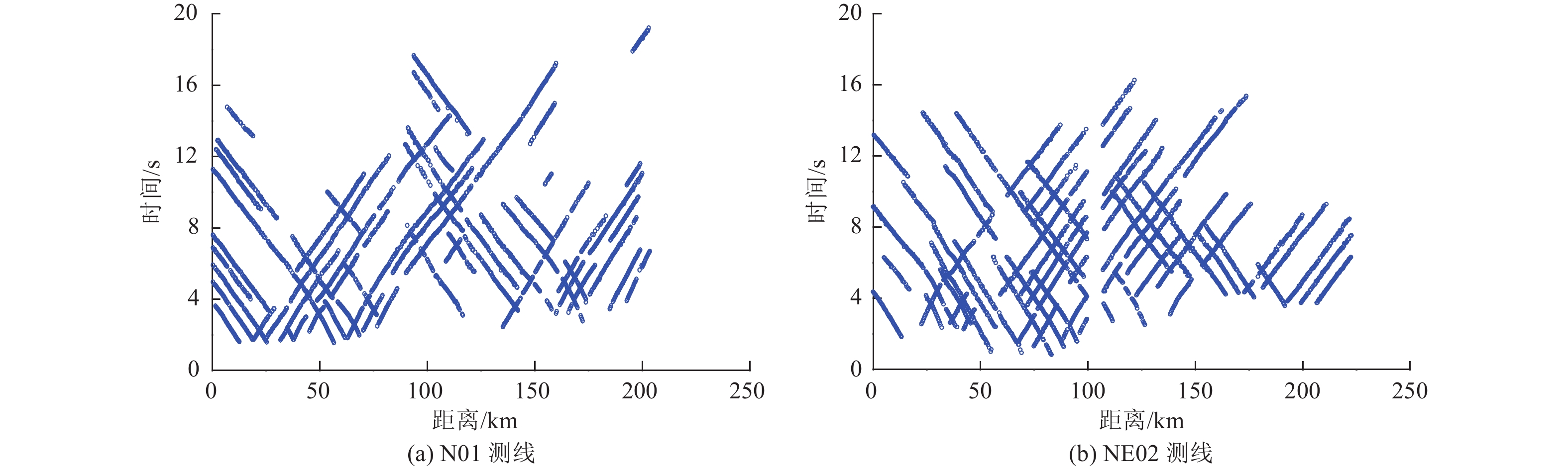
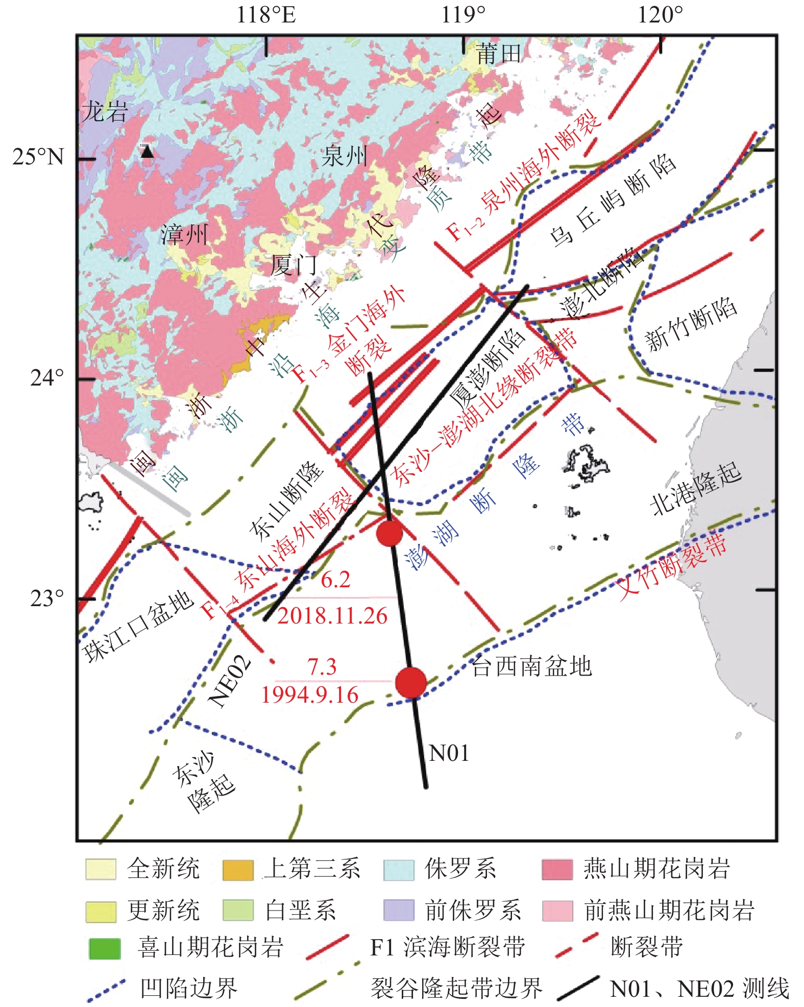
摘要: 对2019年在台湾海峡6.2级地震震区布设的N01、NE02测线地震测深剖面的Pg波走时进行层析成像反演,获得测线下方地壳上部二维速度结构。对N01测线单道反射地震测深剖面进行多次波衰减等处理,并与Pg波成像结果进行对比。研究结果表明,采用走时层析成像方法与单道反射地震测深剖面获得沿探测剖面沉积层上地壳基底形态特征等具有较好的对应关系。由于测线穿越多个地质构造单元和多条断裂带,走时层析成像和单道反射地震测深剖面结果综合显示研究区结晶基底面起伏较大,沉积层速度和厚度变化较剧烈,受台湾海峡西部新生代构造活动影响,显示了相应的断裂或不同地质构造单元在上部地壳内的结构特征。Abstract: The Pg wave travel time of N01 and NE02 deep seismic sounding profiles laid in the MS6.2 Taiwan Strait earthquake region in 2019 was inverted by tomography, and the two-dimensional velocity structure of the upper crust below the survey lines was obtained. The N01 single seismic section was processed by multiple attenuation, and compared with the Pg wave imaging results, there is a good correspondence between the morphological characteristics of the basement. As the survey lines pass through multiple geological tectonic units and multiple fault zones, the results of tomography and single seismic section show that the crystalline basement surface in the study area fluctuates greatly, and the velocity and thickness of the sedimentary layer changes violently. Affected by cenozoic tectonic activities in the western Taiwan Strait, it shows the structural characteristics of the corresponding faults or different geological tectonic units in the upper crust.
-
Key words:
- Taiwan strait /
- Deep seismic exploration /
- Basement structure /
- Seismic profile
-
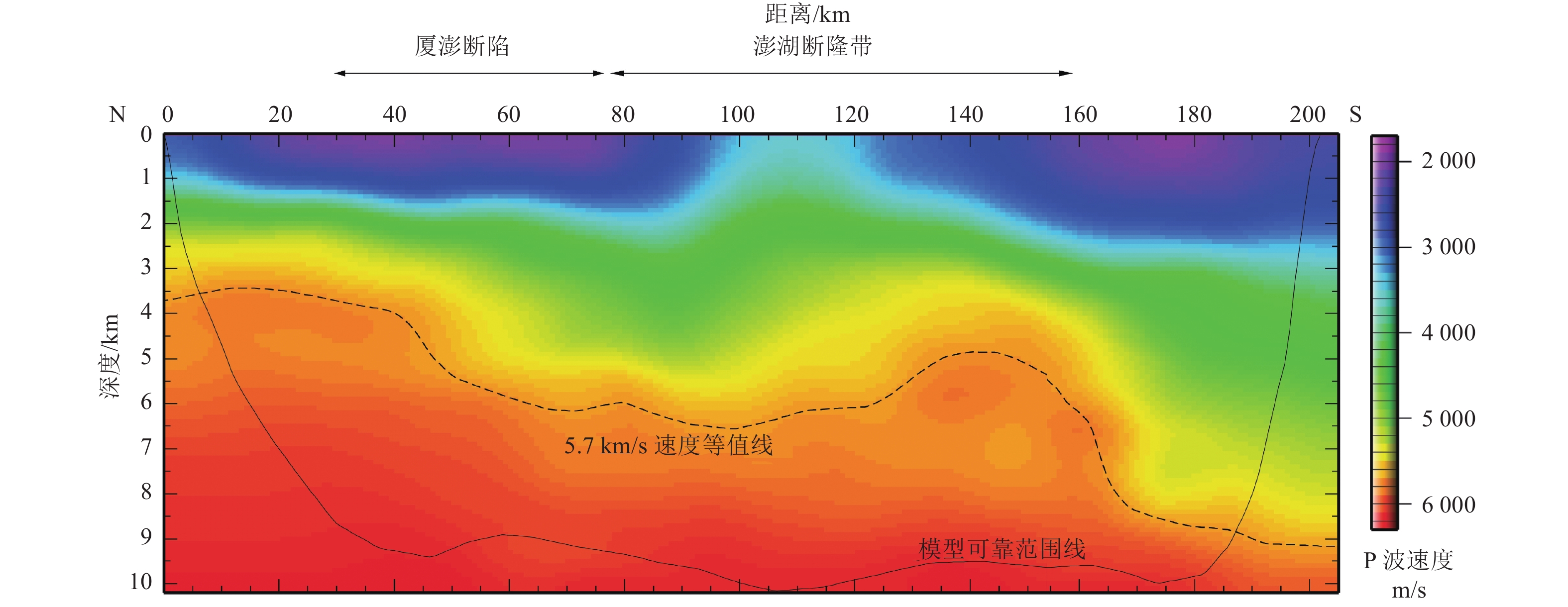
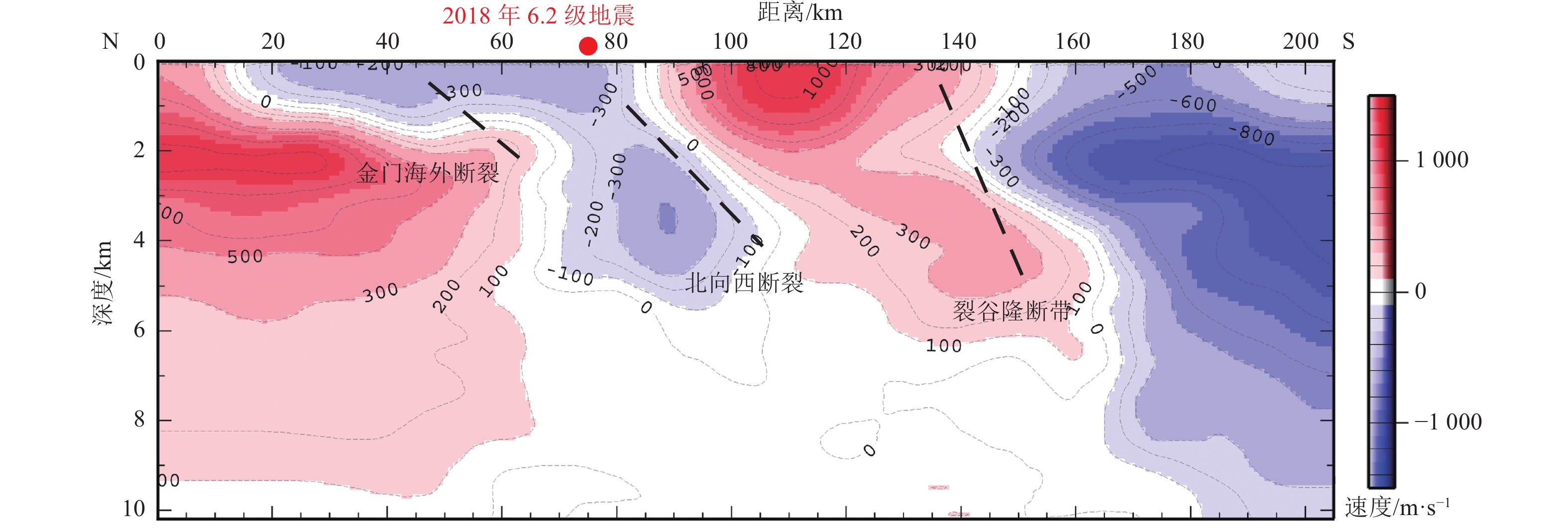
图 6 N01测线剖面基底二维速度结构
Figure 6. The basement two-dimensional velocity structure of N01 profile
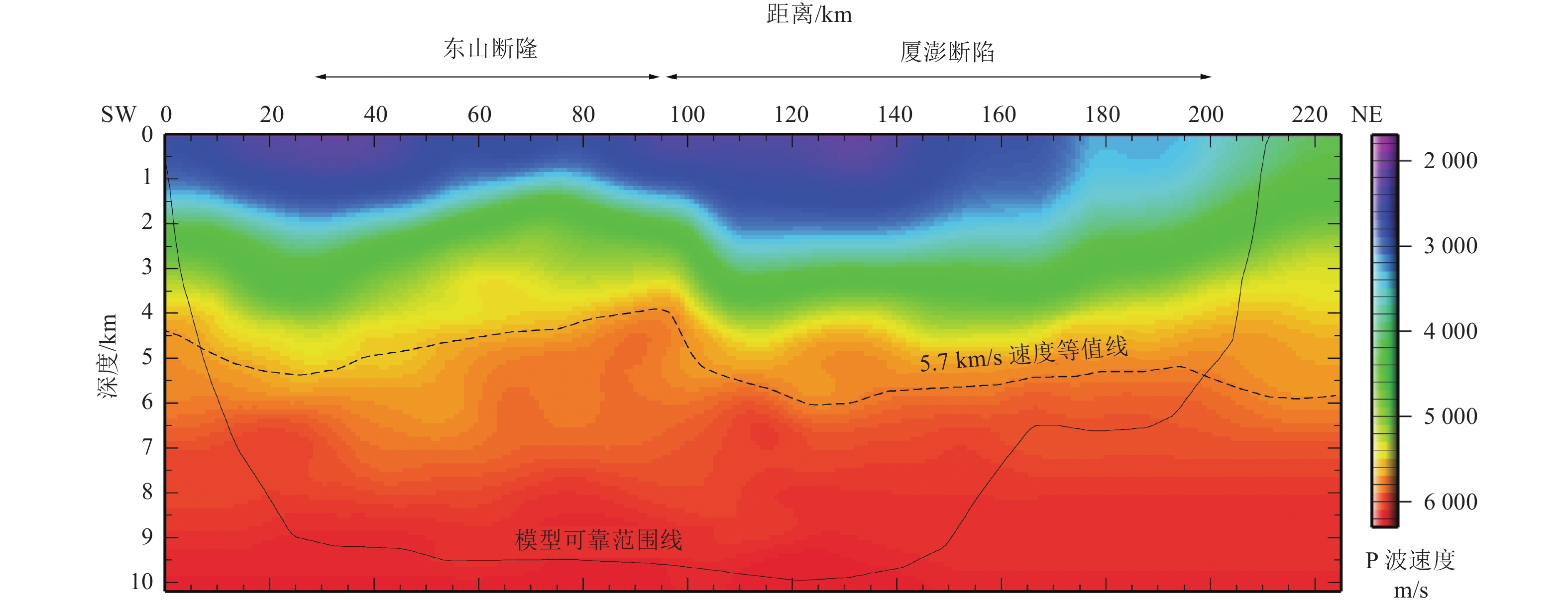
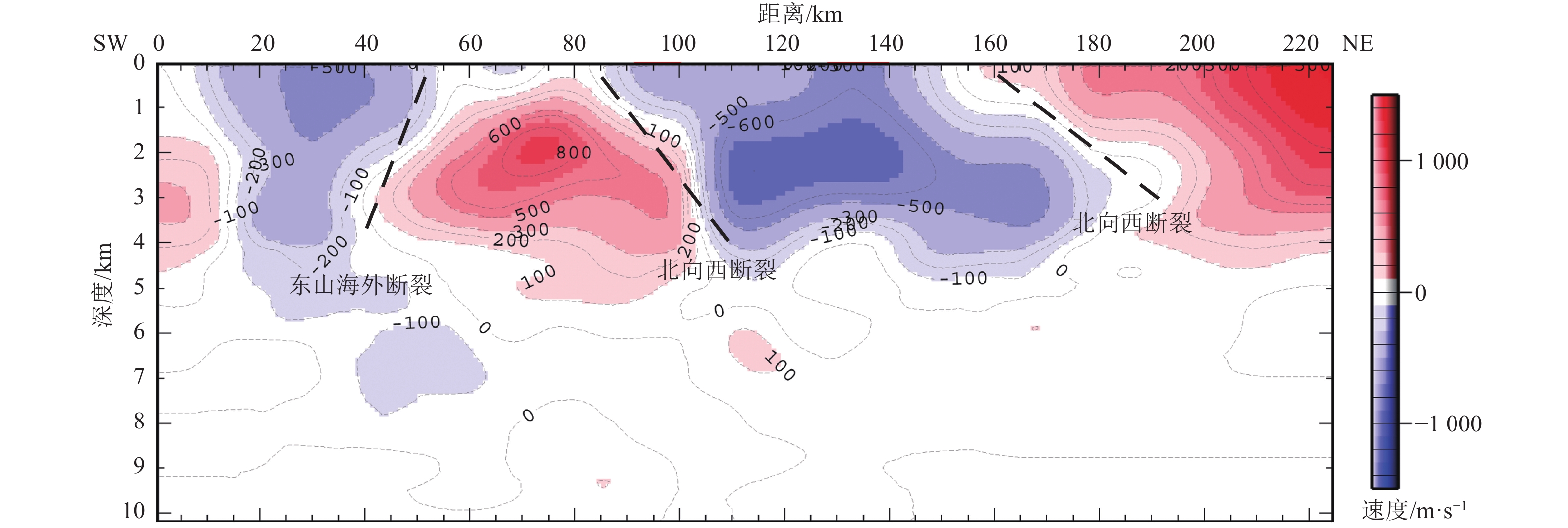
图 7 NE02测线剖面基底二维速度结构
Figure 7. The basement two-dimensional velocity structure of NE02 profile
-
[1] 蔡锋, 曹超, 周兴华等, 2013. 中国近海海洋—海底地形地貌. 北京: 海洋出版社. [2] 陈园田, 谢志平, 1996. 台湾海峡的活动断裂与地震活动. 华南地震, 16(1): 57—62.Chen Y. T., Xie Z. P., 1996. Active faults and earthquakes in Taiwan Strait. South China Journal of Seismology, 16(1): 57—62. (in Chinese) [3] 邓起东, 闽伟, 晁洪太等, 2001. 渤海地区新生代构造与地震活动. 见: 卢演俦主编. 新构造与环境. 北京: 地震出版社, 218—233. [4] 丁祥焕, 1999. 福建东南沿海活动断裂与地震. 福州: 福建科学技术出版社. [5] 郭令智, 施央申, 马瑞士, 1983. 西太平洋中、新生代活动大陆边缘和岛弧构造的形成及演化. 地质学报, 57(1): 11—21.Guo L. Z., Shi Y. S., Ma R. S., 1983. On the formation and evolution of the Mesozoic-Cenozoic active continental margin and island arc tectonics of the western Pacific Ocean. Acta Geologica Sinica, 1983, 57(1): 11—21. (in Chinese) [6] 郭令智, 马瑞士, 施央申等, 1998. 论西太平洋活动大陆边缘中—新生代弧后盆地的分类和演化. 成都理工学院学报, 25(2): 134—144.Guo L. Z., Ma R. S., Shi Y. S., et al., 1998. On the generation and evolution of Mesozoic Cenozoic back arc basins of western Pacific active continental margin. Journal of Chengdu University of Technology, 25(2): 134—144. (in Chinese) [7] 黄昭, 王善雄, 2006. 台湾海峡滨海断裂带的构造特征与活动性. 大地测量与地球动力学, 26(3): 16—22.Huang Z., Wang S. X., 2006. Tectonic features and activity of Binhai Fault zone in Taiwan Strait. Journal of Geodesy and Geodynamics, 26(3): 16—22. (in Chinese) [8] 李赶先, 1994. 台湾海峡新生代断裂构造及其形成演化. 热带海洋, 13(2): 17—24.Li G. X., 1994. The formation and evolution of Cenozoic rifts Taiwan Strait. Tropic Oceanology, 13(2): 17—24. (in Chinese) [9] 戚筱俊, 1999. 台湾海峡地形、地质及地震概述. 西部探矿工程, 11(4): 4—6. [10] 单联瑜, 刘连升, 2007. 三维高阶快速步进波前重构旅行时计算精度分析. 石油地球物理勘探, 42(4): 413—417. doi: 10.3321/j.issn:1000-7210.2007.04.010Shan L. Y., Liu L. S., 2007. Analysis on computation precision of wavefront-reconstructing traveltime for 3-D high-order rapid stepping algorithm. Oil Geophysical Prospecting, 42(4): 413—417. (in Chinese) doi: 10.3321/j.issn:1000-7210.2007.04.010 [11] 王本善, 1995. 台湾海峡地区地质构造特征. 南方油气地质, 2(1): 57—64. [12] 王建, 赵明辉, 贺恩远等, 2014. 初至波层析成像的反演参数选取: 以南海中央次海盆三维地震探测数据为例. 热带海洋学报, 33(5): 74—83. doi: 10.3969/j.issn.1009-5470.2014.05.010Wang J., Zhao M. H., He E. Y., et al., 2014. The selection of optimal inversion parameters for first-arrival seismic tomography: an application to 3D seismic data from the central sub-basin of the South China Sea. Journal of Tropical Oceanography, 33(5): 74-83. (in Chinese) doi: 10.3969/j.issn.1009-5470.2014.05.010 [13] 王笋, 丘学林, 方伟华等, 2018. 台湾海峡西南部的海陆联合深地震探测资料特点与处理对策. 热带海洋学报, 37(2): 92—99.Wang S., Qiu X. L., Fang W. H., et al., 2018. Features of the onshore-offshore seismic data in Southwest Taiwan Strait and some countermeasures for data processing. Journal of Tropical Oceanography, 37(2): 92—99. (in Chinese) [14] 熊绍柏, 刘宏兵, 王有学等, 2002. 华南上地壳速度分布与基底、盖层构造研究. 地球物理学报, 45(6): 784—791. doi: 10.3321/j.issn:0001-5733.2002.06.005Xiong S. B., Liu H. B., Wang Y. X., et al., 2002. A study on velocity distribution in upper crust and tectonics of basement and cover in South China. Chinese Journal of Geophysics, 45(6): 784—791. (in Chinese) doi: 10.3321/j.issn:0001-5733.2002.06.005 [15] 闫培, 张艺峰, 李普春等, 2015. 台湾海峡深地震探测: HX9测线试验及初步成果. 中国地震, 31(1): 27—35. doi: 10.3969/j.issn.1001-4683.2015.01.003Yan P., Zhang Y. F., Li P. C., et al., 2015. Deep seismic exploration in the Taiwan Strait: the experiment of HX9 survey line and preliminary results. Earthquake Research in China, 31(1): 27—35. (in Chinese) doi: 10.3969/j.issn.1001-4683.2015.01.003 [16] 杨肖琪, 宋文隆, 陈承惠, 1996. 台湾海峡地质构造特征. 台湾海峡, 15(2): 127—136.Yang X. Q., Song W. L., Chen C. H., 1996. Characteristics of geological structure in Taiwan Strait. Journal of Oceanography in Taiwan Strait, 15(2): 127—136. (in Chinese) [17] 姚道平, 张艺峰, 闫培等, 2016. 台湾海峡大容量气枪震源海陆联测初探. 地震学报, 38(2): 167—178. doi: 10.11939/jass.2016.02.002Yao D. P., Zhang Y. F., Yan P., et al., 2016. A preliminary exploration into onshore-offshore seismic experiment by using large volume air-gun source in Taiwan Strait. Acta Seismologica Sinica, 38(2): 167—178. (in Chinese) doi: 10.11939/jass.2016.02.002 [18] 俞何兴, 陈汝勤, 1996. 台湾海域之沉积盆地. 台北: 台湾编译馆. [19] 俞何兴, 2006. 台湾海域海底地形及其地质意义. 台北: 台湾大学. [20] 詹文欢, 孙宗勋, 唐诚等, 2004. 华南滨海断裂带及其对台湾海峡地震活动的控制作用. 热带海洋学报, 23(4): 19—24. doi: 10.3969/j.issn.1009-5470.2004.04.003Zhan W. H., Sun Z. X., Tang C., et al., 2004. Littoral active fault belt of south China and its control on seismic activity in Taiwan Strait. Journal of Tropical Oceanography, 23(4): 19—24. (in Chinese) doi: 10.3969/j.issn.1009-5470.2004.04.003 [21] 张艺峰, 金星, 郭晓然等, 2017. 台湾海峡地区深部结构探测数据处理及初步结果. 见: 2017中国地球科学联合学术年会论文集. 北京: 中国地球物理学会. [22] Paige C. C., Saunders M. A., 1982. LSQR: An algorithm for sparse linear equations and sparse least squares. ACM Transactions on Mathematical Software, 8(1): 43—71. doi: 10.1145/355984.355989 [23] Rawlinson N., Sambridge M., 2004a. Wave front evolution in strongly heterogeneous layered media using the fast marching method. Geophysical Journal International, 156(3): 631—647. doi: 10.1111/j.1365-246X.2004.02153.x [24] Rawlinson N., Sambridge M., 2004b. Multiple reflection and transmission phases in complex layered media using a multistage fast marching method. Geophysics, 69(5): 1338—1350. doi: 10.1190/1.1801950 [25] Sethian J. A., 1996. Theory, algorithms, and applications of level set methods for propagating interfaces. Acta Numerica, 5: 309—395. doi: 10.1017/S0962492900002671 [26] Sethian J. A., Popovici A. M., 1999. 3-D traveltime computation using the fast marching method. Geophysics, 64(2): 516—523. doi: 10.1190/1.1444558 [27] Zelt C. A., Barton P. J., 1998. Three-dimensional seismic refraction tomography: a comparison of two methods applied to data from the Faeroe Basin. Journal of Geophysical Research: Solid Earth, 103(B4): 7187—7210. doi: 10.1029/97JB03536 -

 下载:
下载:

 点击查看大图
图(10)
计量
- 文章访问数: 238
- HTML全文浏览量: 98
- PDF下载量: 16
- 被引次数: 0
