
Application of High-precision UAV Aerial Survey in the Detailed Study of Surface Rupture of Maduo MS7.4 Earthquake in 2021
-
摘要: 北京时间2021年5月22日,青海省果洛州玛多县发生MS7.4地震,震中位于巴颜喀拉地块内部,根据震源机制解和野外地表破裂调查确定发震构造为以左旋走滑运动为主的江错断裂。本研究利用大疆Phantom 4 RTK无人机在震后采集大量地表破裂照片,采用集成SfM(Structure from Motion)算法的PhotoScan软件处理获得高分辨率DEM和正射影像,同时结合野外实地考察对研究区地表破裂的分布特征及断错地貌类型进行详细解译。利用基于MATLAB语言开发的位移测量软件LaDiCaoz,限定玛多地震在研究区产生的左旋走滑位移约为0.4 m。地表破裂精细化解译显示,在左旋右阶阶区发育小规模的挤压鼓包和里德尔共轭剪切破裂,在左旋左阶阶区发育走向为N40°~50°E,宽度达数十厘米的张裂缝带,指示发震构造的左旋走滑性质。本研究为震后基于无人机摄影测量技术快速提取地表破裂的定量参数和进行地表破裂精细化研究提供了可行、高效和科学的技术方法。Abstract: On May 22, 2021 (Beijing time), an Ms 7.4 earthquake occurred in Maduo county, Guoluo prefecture, Qinghai province. The epicenter was located in the Bayan Har Block, and the seismogenic structure was determined to be Jiangcuo fault with left-lateral strike-slip movement based on the focal mechanism solution and field investigation of surface rupture. In this study, the DJI Phantom 4 RTK UAV was used to collect a large number of photos of the surface rupture after the earthquake, and PhotoScan software integrated with the Structure from Motion (SfM) algorithm was used to obtain DEM and ortho images with high resolution. At the same time, combined with field investigation, the distribution characteristics of surface rupture and the types of displaced landform in the study area were interpreted in detail. Using the graphical dislocation measurement software LaDiCaoz developed based on Matlab, the left-lateral strike-slip displacement of Maduo earthquake in the study area is limited to 0.4 m. The results of the detailed interpretation of surface fractures show that there are small-scale compressional swelling and Riedel conjugate shear cracks in the left-lateral right-stepping zone and tensional fracture zones with a strike of N40°~50°E and a width of tens of centimeters in the sinistral left-steeping zone, indicating the sinistral strike-slip nature of the seismogenic fault. This study provides a feasible, efficient, and scientific-technical method for the rapid extraction of quantitative parameters of surface rupture and the detailed analysis of surface rupture based on UAV photogrammetry technology after large earthquakes.
-
Key words:
- UAV aerial survey /
- Surface rupture /
- Coseismic displacement
-
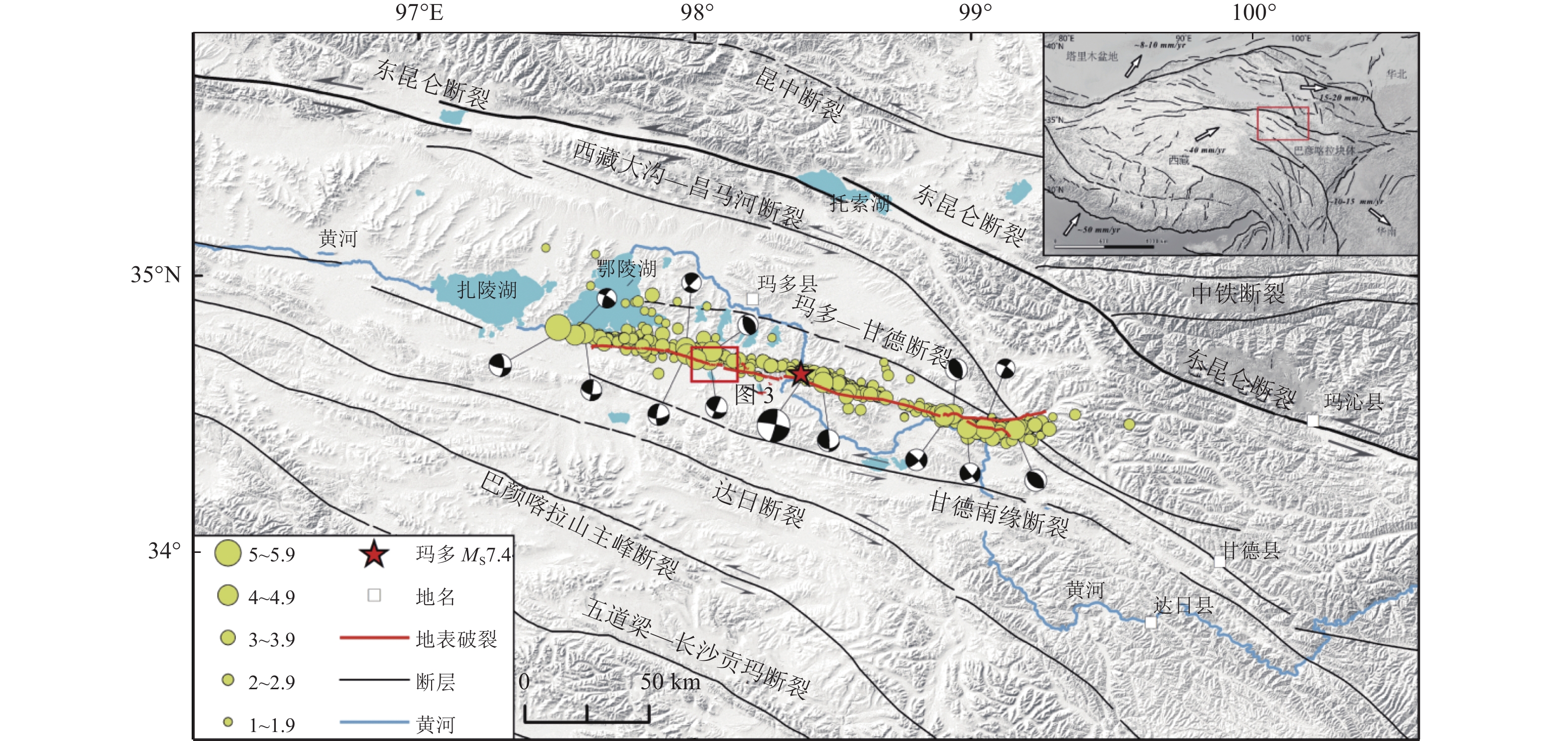
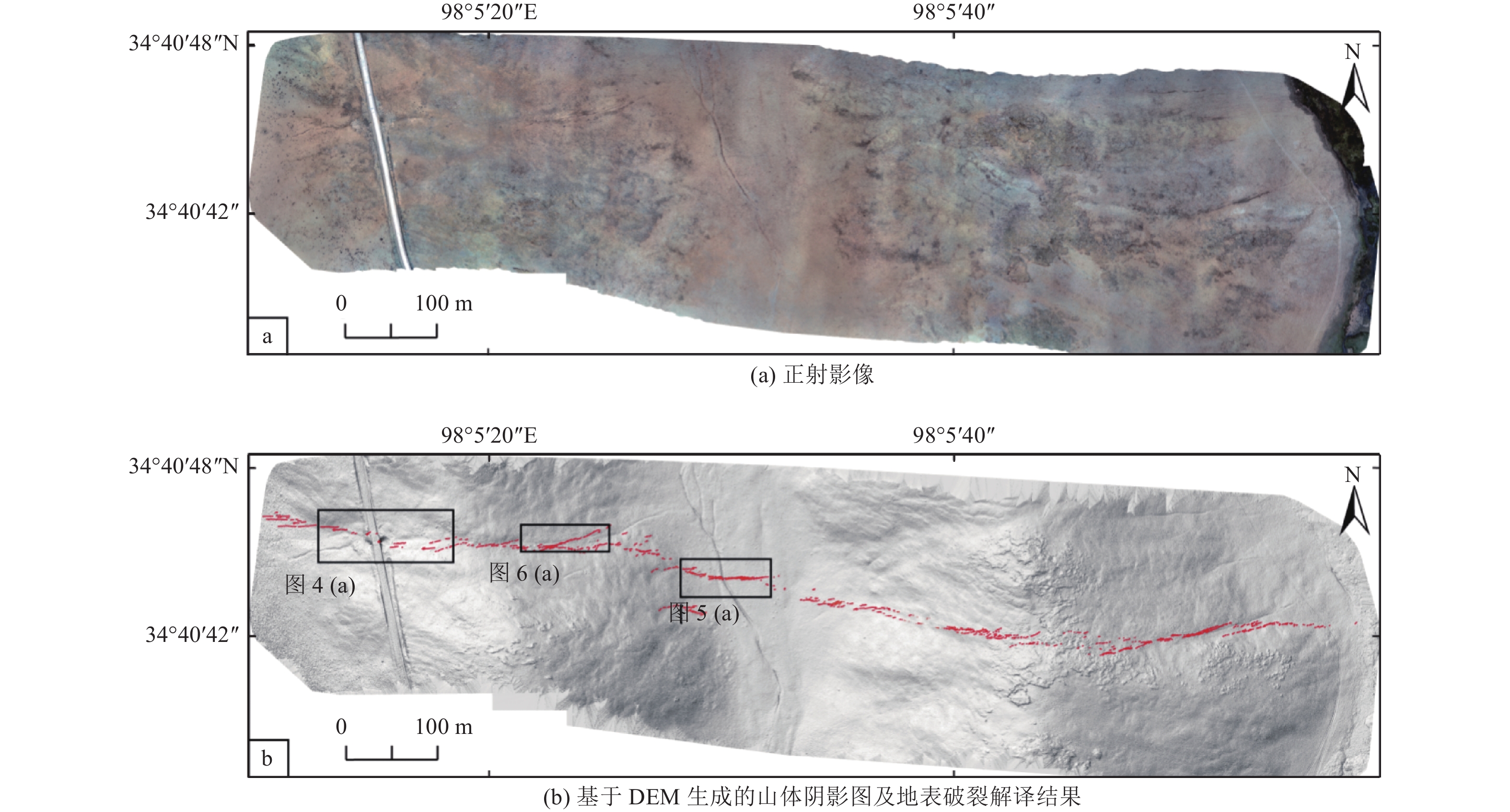
图 1 2021年玛多MS7.4地震区域地震构造图
Figure 1. Regional seismotectonic map of 2021 Maduo MS7.4 earthquake
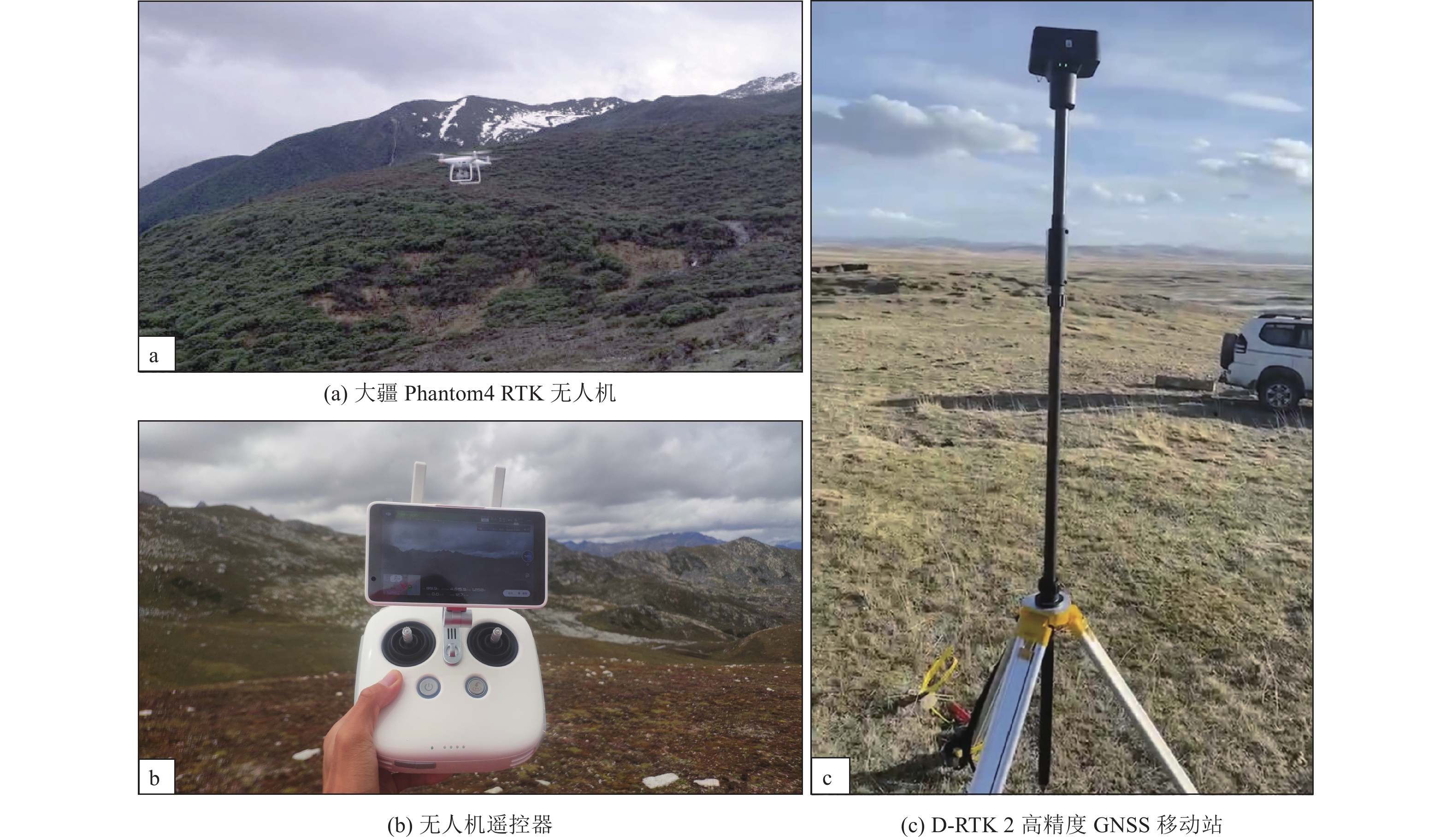
图 2 无人机系统及研究区地貌特征
Figure 2. UAV system and geomorphic characteristics of the study area
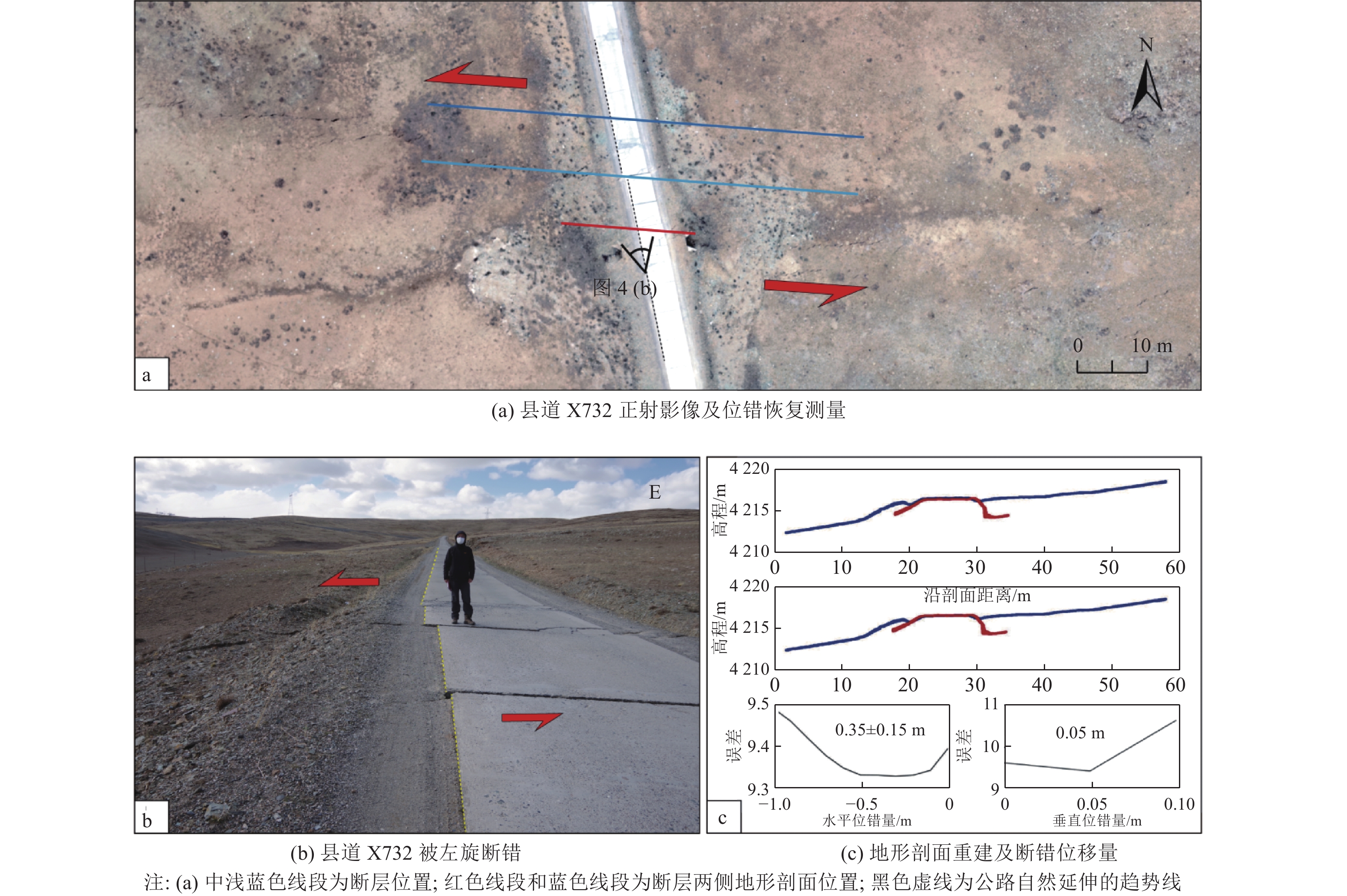
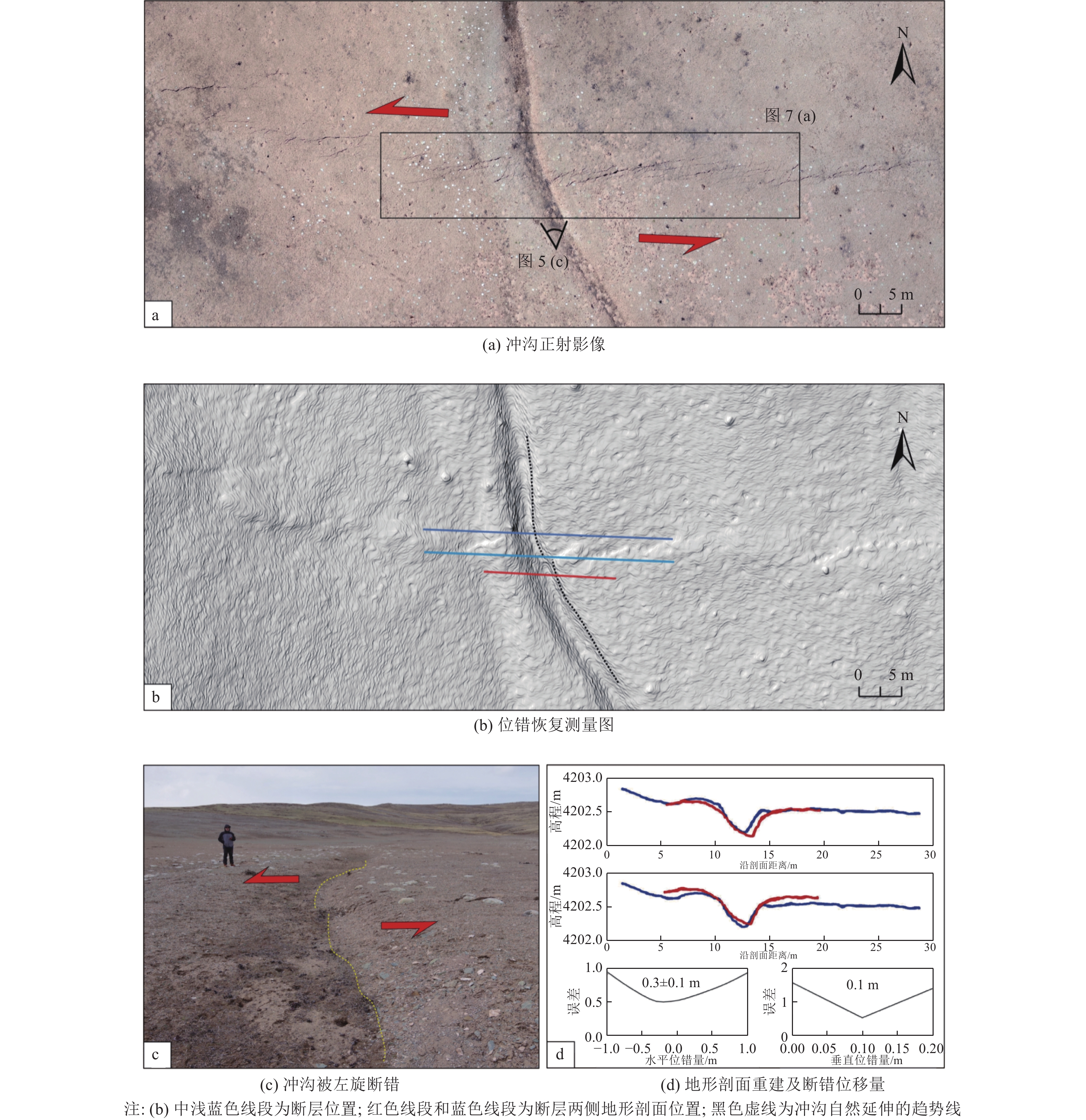
图 4 公路左旋断错位移提取
Figure 4. Extraction of left-lateral strike-slip displacement of highway
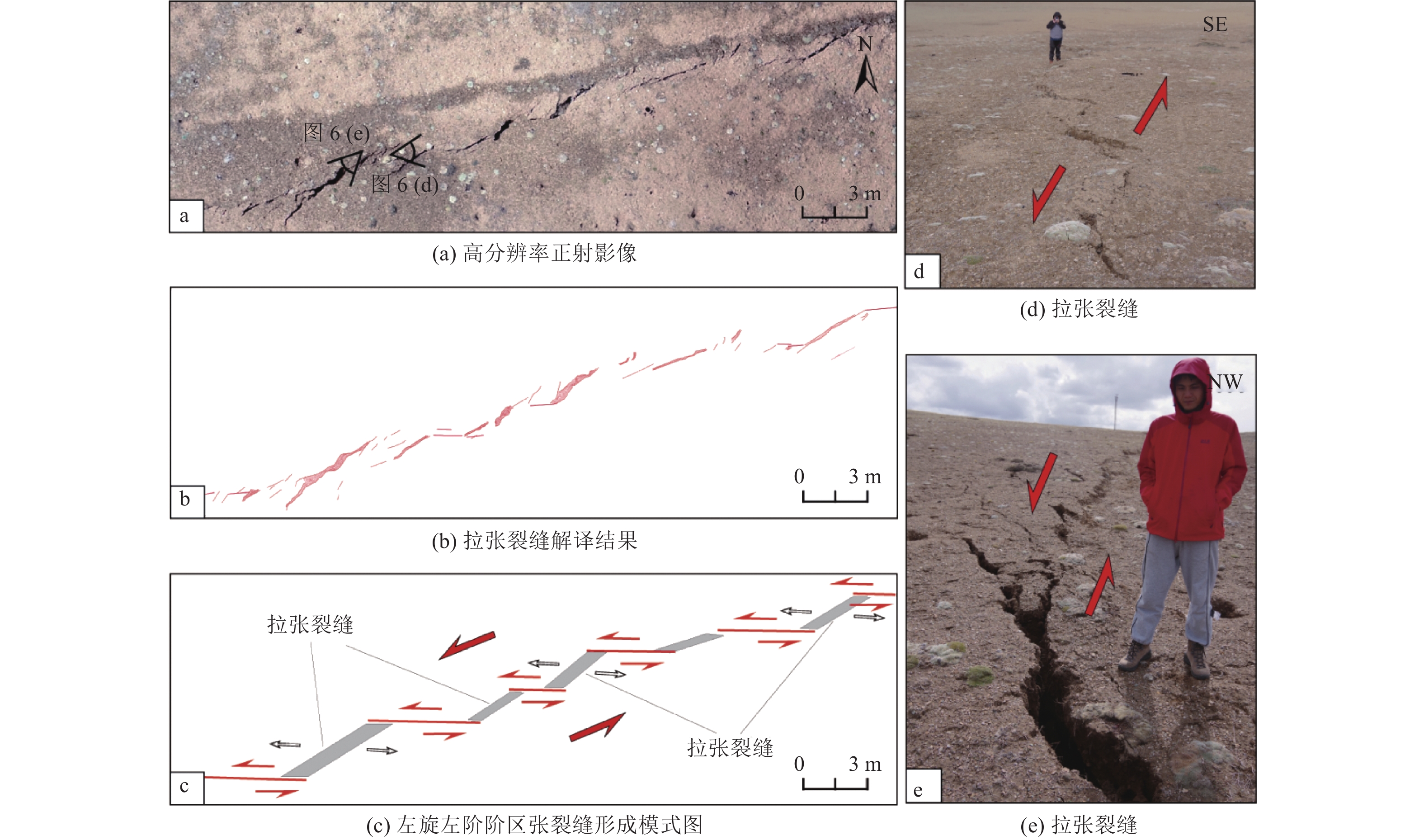
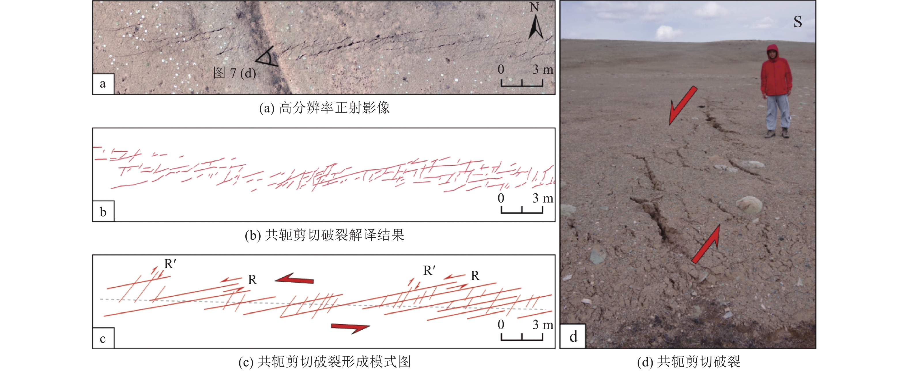
图 6 左旋左阶阶区张裂缝精细结构与形成机制
Figure 6. The detailed structure and kinematic mechanism of tensioning fracture in sinistral left-stepping zone
-
[1] 陈立春, 王虎, 冉勇康等, 2010. 玉树MS7.1级地震地表破裂与历史大地震. 科学通报, 55(13): 1200—1205.Chen L. C., Wang H., Ran Y. K., et al., 2010. The MS7.1 Yushu earthquake surface rupture and large historical earthquakes on the Garzê-Yushu Fault. Chinese Science Bulletin, 55(31): 3504—3509. (in Chinese) [2] 程佳, 徐锡伟, 甘卫军等, 2012. 青藏高原东南缘地震活动与地壳运动所反映的块体特征及其动力来源. 地球物理学报, 55(4): 1198—1212 doi: 10.6038/j.issn.0001-5733.2012.04.016Cheng J. , Xu X. W. , Gan W. J. , et al. , 2012. Block model and dynamic implication from the earthquake activities and crustal motion in the southeastern margin of Tibetan Plateau. Chinese Journal of Geophysics, 55(4): 1198—1212. (in Chinese) doi: 10.6038/j.issn.0001-5733.2012.04.016 [3] 邓起东, 2007. 中国活动构造图. 北京: 地震出版社.Deng Q. D., 2007. Map of active tectonics in China. Beijing: Seismological Press. (in Chinese) [4] 邓起东, 闻学泽, 2008. 活动构造研究——历史、进展与建议. 地震地质, 30(1): 1—30 doi: 10.3969/j.issn.0253-4967.2008.01.002Deng Q. D. , Wen X. Z. , 2008. A review on the research of active tectonics——history, progress and suggestions. Seismology and Geology, 30(1): 1—30. (in Chinese) doi: 10.3969/j.issn.0253-4967.2008.01.002 [5] 邓起东, 高翔, 陈桂华等, 2010. 青藏高原昆仑—汶川地震系列与巴颜喀喇断块的最新活动. 地学前缘, 17(5): 163—178Deng Q. D. , Gao X. , Chen G. H. , et al. , 2010. Recent tectonic activity of Bayankala fault-block and the Kunlun-Wenchuan earthquake series of the Tibetan Plateau. Earth Science Frontiers, 17(5): 163—178. (in Chinese) [6] 邓起东, 程绍平, 马冀等, 2014. 青藏高原地震活动特征及当前地震活动形势. 地球物理学报, 57(7): 2025—2042 doi: 10.6038/cjg20140701Deng Q. D. , Cheng S. P. , Ma J. , et al. , 2014. Seismic activities and earthquake potential in the Tibetan Plateau. Chinese Journal of Geophysics, 57(7): 2025—2042. (in Chinese) doi: 10.6038/cjg20140701 [7] 高帅坡, 2017. 基于无人机摄影测量技术的活动构造定量参数提取研究. 北京: 中国地震局地质研究所.Gao S. P. , 2017. A quantitative parameters extraction study of active tectonics based on UAV photogrammetry technology. Beijing: Institute of Geology, China Earthquake Administrator. (in Chinese) [8] 荆帅军, 帅向华, 甄盟, 2019. 基于无人机倾斜影像的三维建筑物震害精细信息提取. 地震学报, 41(3): 366—376Jing S. J. , Shuai X. H. , Zhen M. , 2019. Fine information extraction of 3D building seismic damage based on unmanned aerial vehicle oblique images. Acta Seismologica Sinica, 41(3): 366—376. (in Chinese) [9] 康文君, 徐锡伟, 于贵华等, 2020.2种基于Matlab平台的断层位移测量软件对比分析——以阿尔金断裂东段为例. 地震地质, 42(3): 732—747 doi: 10.3969/j.issn.0253-4967.2020.03.013Kang W. J. , Xu X. W. , Yu G. H. , et al. , 2020. Comparison study of two kinds of codes to measure fault-offsets based on Matlab: a case study on eastern Altyn Tagh Fault. Seismology and Geology, 42(3): 732—747. (in Chinese) doi: 10.3969/j.issn.0253-4967.2020.03.013 [10] 李金香, 常想德, 姚远等, 2019. 无人机技术在新疆塔县地震的应用及实现. 华南地震, 39(3): 57—64Li J. X. , Chang X. D. , Yao Y. , et al. , 2019. Application and realization of UAV technology in the earthquake of Tajik Autonomous County of Taxkorgan, Xinjiang. South China Journal of Seismology, 39(3): 57—64. (in Chinese) [11] 李云, 徐伟, 吴玮, 2011. 灾害监测无人机技术应用与研究. 灾害学, 26(1): 138—143 doi: 10.3969/j.issn.1000-811X.2011.01.026Li Y. , Xu W. , Wu W. , 2011. Application research on aviation remote sensing UAV for disaster monitoring. Journal of Catastrophology, 26(1): 138—143. (in Chinese) doi: 10.3969/j.issn.1000-811X.2011.01.026 [12] 李智敏, 李文巧, 李涛等, 2021.2021年5月22日青海玛多MS7.4地震的发震构造和地表破裂初步调查. 地震地质, 43(3): 722—737Li Z. M., Li W. Q., Li T., et al., 2021. Seismogenic fault and coseismic surface deformation of the Maduo MS7.4 earthquake in Qinghai, China: a quick report. Seismology and Geology, 43(3): 722—737. (in Chinese) [13] 刘超, 雷启云, 余思汗等, 2021. 基于无人机摄影测量技术的地震地表破裂带定量参数提取——以1709年中卫南M7½地震为例. 地震学报, 43(1): 113—123 doi: 10.11939/jass.20200039Liu C. , Lei Q. Y. , Yu S. H. , et al. , 2021. Using UAV photogrammetry technology to extract the quantitative parameters of earthquake surface rupture zone: a case study of the southern Zhongwei M7½ earthquake in 1709. Acta Seismologica Sinica, 43(1): 113—123. (in Chinese) doi: 10.11939/jass.20200039 [14] 刘静, 陈涛, 张培震等, 2013. 机载激光雷达扫描揭示海原断裂带微地貌的精细结构. 科学通报, 58(1): 41—45 doi: 10.1360/972012-1526Liu J. , Chen T. , Zhang P. Z. , et al. , 2013. Illuminating the active Haiyuan fault, China by airborne light detection and ranging. Chinese Science Bulletin, 58(1): 41—45. (in Chinese) doi: 10.1360/972012-1526 [15] 陆博迪, 孟迪文, 陆鸣等, 2011. 无人机在重大自然灾害中的应用与探讨. 灾害学, 26(4): 122—126 doi: 10.3969/j.issn.1000-811X.2011.04.024Lu B. D. , Meng D. W. , Lu M. , et al. , 2011. Application and exploration of unmanned aerial vehicle in major natural disasters. Journal of Catastrophology, 26(4): 122—126. (in Chinese) doi: 10.3969/j.issn.1000-811X.2011.04.024 [16] 潘家伟, 白明坤, 李超等, 2021.2021年5月22日青海玛多MS7.4地震地表破裂带及发震构造. 地质学报, 95(6): 1655—1670Pan J. W. , Bai M. K. , Li C. , et al. , 2021. Coseismic surface rupture and seismogenic structure of the 2021-05-22 Maduo (Qinghai)MS7.4 earthquake. Acta Geologica Sinica, 95(6): 1655—1670. (in Chinese) [17] 孙稳, 何宏林, 魏占玉等, 2019. 基于无人机航测获取高分辨率DEM数据的断层几何结构精细解译与分析——以海原断裂唐家坡为例. 地震地质, 41(6): 1350—1365 doi: 10.3969/j.issn.0253-4967.2019.06.003Sun W. , He H. L. , Wei Z. Y. , et al. , 2019. Interpretation and analysis of the fine fault geometry based on high-resolution DEM data derived from UAV photogrammetric technique: a case study of Tangjiapo site on the Haiyuan Fault. Seismology and Geology, 41(6): 1350—1365. (in Chinese) doi: 10.3969/j.issn.0253-4967.2019.06.003 [18] 铁瑞, 王俊, 贾连军等, 2016. 强震地震数据统计及其地表破裂特性研究. 世界地震工程, 32(1): 112—116Tie R. , Wang J. , Jia L. J. , et al. , 2016. Data statistics of strong-moderate earthquake and characteristics research of ground rupture. World Earthquake Engineering, 32(1): 112—116. (in Chinese) [19] 闻学泽, 2018. 巴颜喀拉块体东边界千年破裂历史与2008年汶川、2013年芦山和2017年九寨沟地震. 地震学报, 40(3): 255—267 doi: 10.11939/jass.20170211Wen X. Z. , 2018. The 2008 Wenchuan, 2013 Lushan and 2017 Jiuzhaigou earthquakes, Sichuan, in the last more than one thousand years of rupture history of the eastern margin of the Bayan Har block. Acta Seismologica Sinica, 40(3): 255—267. (in Chinese) doi: 10.11939/jass.20170211 [20] 徐锡伟, 陈文彬, 于贵华等, 2002.2001年11月14日昆仑山库赛湖地震(MS8.1)地表破裂带的基本特征. 地震地质, 24(1): 1—13Xu X. W., Chen W. B., Yu G. H., et al., 2002. Characteristic features of the surface ruptures of the Hoh Sai Hu (Kunlunshan) earthquake (MS8.1), northern Tibetan Plateau, China. Seismology and Geology, 24(1): 1—13. (in Chinese) [21] 徐锡伟, 陈桂华, 2018. 活动断层避让问题探讨与建议. 城市与减灾, (1): 8—13. doi: 10.3969/j.issn.1671-0495.2018.01.004 [22] 姚鑫, 周振凯, 李凌婧等, 2017.2017年四川九寨沟Ms7.0地震InSAR同震形变场及发震构造探讨. 地质力学学报, 23(4): 507—514Yao X. , Zhou Z. K. , Li L. J. , et al. , 2017. InSAR co-seismic deformation of 2017 Ms7.0 Jiuzhaigou earthquake and discussions on seismogenic tectonics. Journal of Geomechanics, 23(4): 507—514. (in Chinese) [23] 张培震, 邓起东, 张国民等, 2003. 中国大陆的强震活动与活动地块. 中国科学D辑, 33(S1): 12—20.Zhang P. Z., Deng Q. D., Zhang G. M., et al., 2003. Active tectonic blocks and strong earthquakes in the continent of China. Science in China Series D: Earth Sciences, 46(S2): 13—24. [24] 张培震, 徐锡伟, 闻学泽等, 2008.2008年汶川8.0级地震发震断裂的滑动速率、复发周期和构造成因. 地球物理学报, 51(4): 1066—1073Zhang P. Z. , Xu X. W. , Wen X. Z. , et al. , 2008. Slip rates and recurrence intervals of the Longmen Shan active fault zone and tectonic implications for the mechanism of the May 12 Wenchuan earthquake, 2008, Sichuan, China. Chinese Journal of Geophysics, 51(4): 1066—1073. (in Chinese) [25] 中国地震局地球物理研究所, 2021. 2021年5月22日青海果洛州玛多县7.4级地震应急科技支撑简报. (2021-05-22)[2021-11-01]. http://www.cea-igp.ac.cn/kydt/278249.html. [26] Deng Q. D. , Wu D. M. , Zhang P. Z. , et al. , 1986. Structure and deformational character of strike-slip fault zones. Pure and Applied Geophysics, 124(1—2): 203—223. [27] Fossen H. , 2010. Structural geology. Cambridge: Cambridge University Press. [28] Johnson K. , Nissen E. , Saripalli S. , et al. , 2014. Rapid mapping of ultrafine fault zone topography with structure from motion. Geosphere, 10(5): 969—986. doi: 10.1130/GES01017.1 [29] Klinger Y. , Etchebes M. , Tapponnier P. , et al. , 2011. Characteristic slip for five great earthquakes along the Fuyun fault in China. Nature Geoscience, 4(6): 389—392. doi: 10.1038/ngeo1158 [30] Lin Z. , Kaneda H. , Mukoyama S. , et al. , 2013. Detection of subtle tectonic–geomorphic features in densely forested mountains by very high-resolution airborne LiDAR survey. Geomorphology, 182: 104—115. doi: 10.1016/j.geomorph.2012.11.001 [31] Oskin M. E. , Arrowsmith J. R. , Corona A. H. , et al. , 2012. Near-field deformation from the El Mayor-Cucapah earthquake revealed by differential LIDAR. Science, 335(6069): 702—705. doi: 10.1126/science.1213778 [32] USGS (United States Geological Survey), 2021. M7.3-southern Qinghai, China-Moment tensor. (2021-05-21)[2021-11-01]. https://earthquake.usgs.gov/earthquakes/eventpage/us7000e54r/executive. [33] Wallace R. E. , 1998. The geology of earthquakes. Eos, Transactions American Geophysical Union, 79(9): 115. [34] Wang S. F., Fan C., Wang G., et al., 2008. Late Cenozoic deformation along the northwestern continuation of the Xianshuihe fault system, Eastern Tibetan Plateau. GSA Bulletin, 120(3—4): 312—327. [35] Zhou Y. , Parsons B. , Elliott J. R. , et al. , 2015. Assessing the ability of Pleiades stereo imagery to determine height changes in earthquakes: a case study for the El Mayor‐Cucapah epicentral area. Journal of Geophysical Research, 120(12): 8793—8808. [36] Zielke O. , Arrowsmith J. R. , Ludwig L. G. , et al. , 2010. Slip in the 1857 and earlier large earthquakes along the Carrizo Plain, San Andreas fault. Science, 327(5969): 1119—1122. doi: 10.1126/science.1182781 [37] Zielke O. , Arrowsmith J. R. , 2012. LaDiCaoz and LiDARimager—MATLAB GUIs for LiDAR data handling and lateral displacement measurement. Geosphere, 8(1): 206—221. doi: 10.1130/GES00686.1 -

 下载:
下载:
 点击查看大图
计量
- 文章访问数: 232
- HTML全文浏览量: 88
- PDF下载量: 23
- 被引次数: 0
