
Research on the Model of UAV Fast 3D Positioning of Trapped People after Earthquake
-
摘要: 针对震后被倒塌建筑物或滑坡埋压的被困人员进行快速定位问题,在阅读大量相关文献的基础上,以无人机遥感、地理信息空间和三维质心定位技术为基础,采用无线信号RSSI测距模型,配合影像范围内基准影像数据辅助定位,构建震后基于无人机快速三维定位被困人员模型。以红河县城区作为研究区,对城区内特定人员进行三维定位,结果表明该模型定位精度高,对震后废墟被困人员营救具有重要意义。Abstract: To locate the trapped people who are buried under the collapse of buildings or landslides after the earthquake, on the basis of reading a large number of relevant literatures and based on uav remote sensing, geographic information space and three-dimensional centroid positioning technology, the wireless signal RSSI ranging model is adopted to coordinate with the reference image data in the image range for auxiliary positioning, so as to construct a set of post-earthquake rapid 3D positioning model of trapped persons based on UAV. Taking Honghe County urban area as the research area, the 3D positioning of specific personnel in the urban area is carried out. The results show that the model has high positioning accuracy and is of great significance to rescue the trapped people after the earthquake.
-
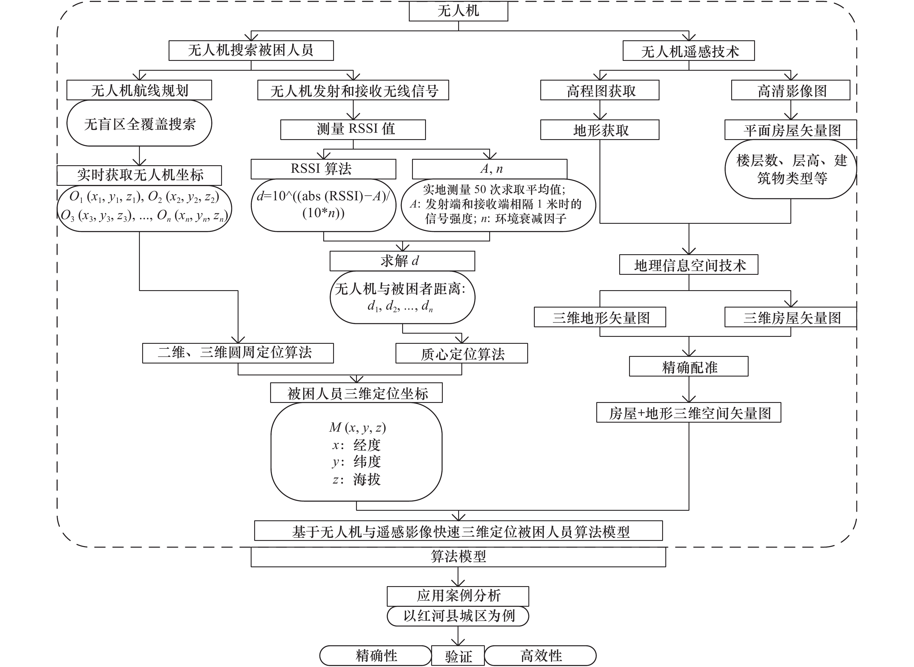
图 1 震后基于无人机快速三维定位被困人员模型流程图
Figure 1. The flow chart of the model of the trapped people based on the uav fast 3D positioning after the earthquake
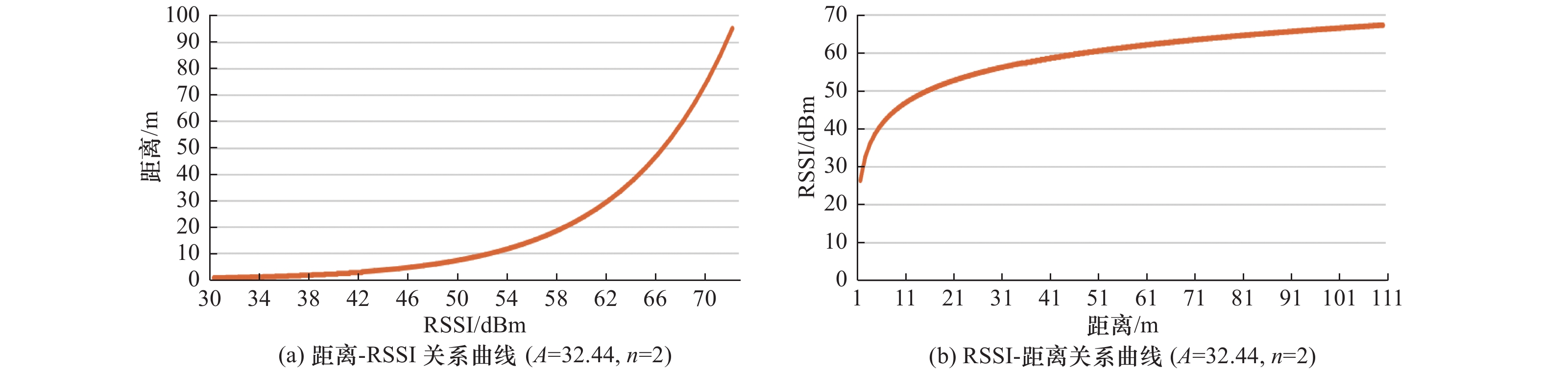
图 2 理想状态下RSSI与距离对应关系
Figure 2. The correspondence between RSSI and distance value under ideal state
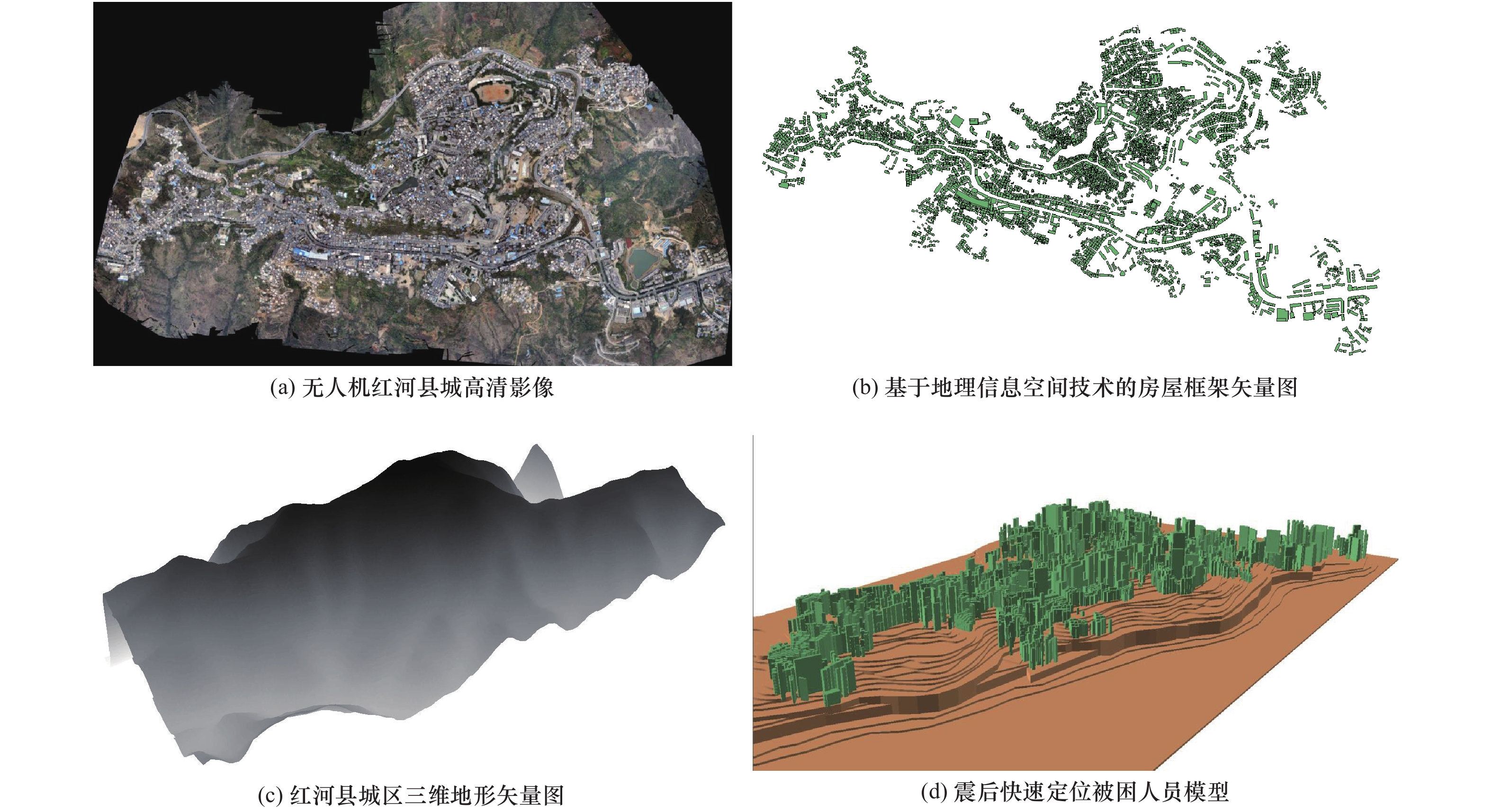
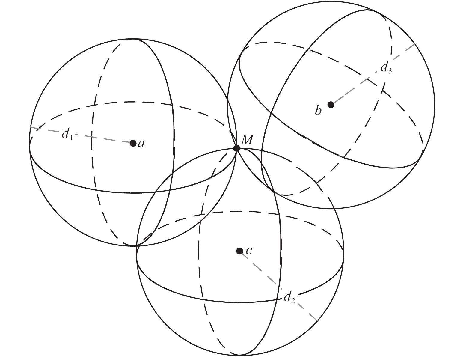
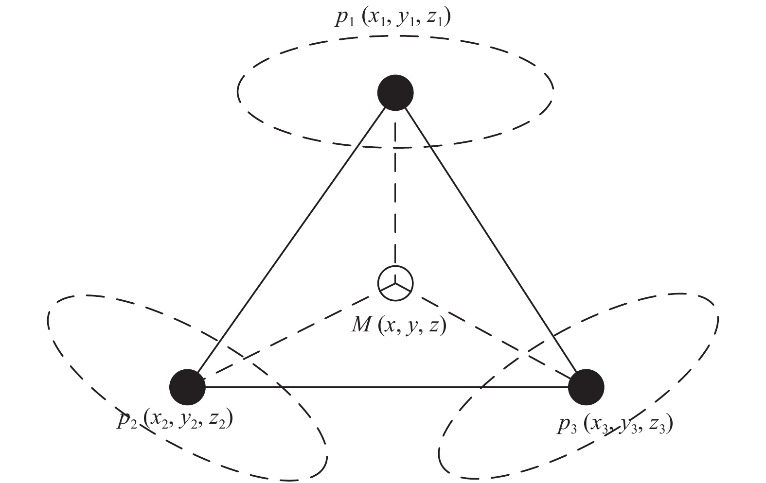
图 5 基础模型
Figure 5. The fundamental model (a)、The vector diagram of house frame based on geographic information space technology (b)、The 3D vector topography of Honghe county (c)、The model of fast location of trapped people after earthquake (d)
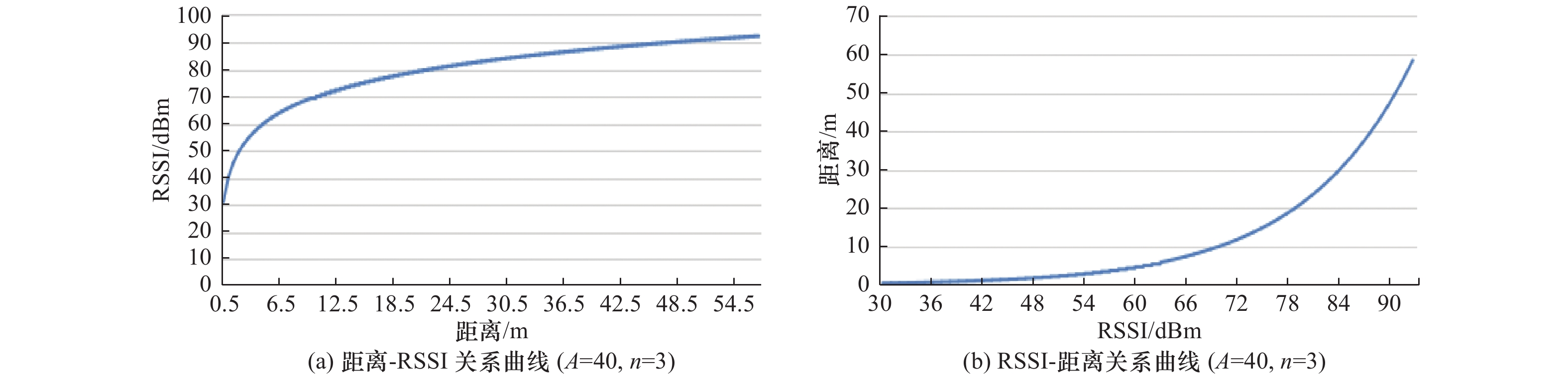
图 7 本研究RSSI与距离对应关系
Figure 7. The correspondence between RSSI and distance value in this study
表 1 模型结果
Table 1. The results of model algorithm
序号 MAC地址 物理层协议 RSSI 信号质量 平均信号质量 频率 通道 信息数 最大速度/
Mbps带宽/
MHz第一次
检测最后一次
检测是否连接 经度/° 纬度/° 海拔/m 1 68-A0-3E-D8-39-68 802.11g/n/ac −70.6357 65 63 2.462 11 16 390 20 09:23:09 09:23:15 否 102.418763 23.373135 989.23 2 98-E7-F5-88-9A-53 802.11g/n −79.6666 58 57 2.462 11 13 450 20 09:26:14 09:26:30 是 102.421803 23.375657 978.75 3 B8-94-36-1C-17-B6 802.11g/n −83.6453 51 49 2.437 6 13 144 20 09:29:40 09:30:01 否 102.424242 23.373963 971.17 4 B8-94-36-49-97-38 802.11g/n −88.2236 49 47 2.462 11 13 144 20 09:33:08 09:33:21 否 102.403974 23.372365 966.57 5 E6-8F-F4-93-F0-80 802.11g/n −88.8517 49 48 2.462 11 16 144 20 09:36:25 09:36:31 否 102.405390 23.373218 952.45 6 96-E5-DE-7C-56-C6 802.11g/n −86.8687 47 45 2.462 11 15 144 20 09:39:35 09:39:45 否 102.406310 23.371309 959.84 7 88-11-96-3A-C3-8A 802.11g/n −82.6973 39 38 2.437 6 12 72 20 09:42:43 09:42:59 否 102.408521 23.370730 957.34 8 AE-26-9B-CA-D1-96 802.11g/n −83.1799 41 40 2.437 6 17 144 20 09:45:21 09:45:35 否 102.409911 23.372194 963.18 9 78-44-FD-C4-AC-C7 802.11g/n −78.0151 60 58 2.462 11 19 300 40 09:48:31 09:48:45 否 102.412029 23.372019 973.19 10 14-3C-C3-6E-35-CE 802.11g/n/ac −70.6356 65 64 2.462 11 16 390 20 09:51:16 09:51:42 否 102.414051 23.370901 972.57 11 80-8A-8B-FD-6A-9F 802.11g/n/ac −70.0237 63 62 2.417 2 16 780 20 09:54:20 09:54:33 否 102.417008 23.372129 981.41 12 82-89-17-C4-A2-47 802.11g/n −79.3526 57 56 2.437 6 12 300 40 09:57:27 09:57:46 否 102.418084 23.372371 989.17 13 C6-8B-BD-37-4C-7B 802.11g/n −81.1323 40 38 2.437 6 16 144 20 10:00:02 10:00:10 否 102.418932 23.371930 989.87 14 20-54-FA-58-35-DA 802.11g/n −85.5554 48 46 2.412 1 15 72 20 10:03:09 10:03:15 否 102.417509 23.371243 979.23 15 88-F8-72-98-3F-A1 802.11g/n/ac −90.0235 34 33 2.437 6 15 390 20 10:06:45 10:06:58 否 102.416266 23.371261 976.01 16 60-83-34-92-AC-F5 802.11g/n −88.2236 38 37 2.437 6 16 300 40 10:09:19 10:09:28 否 102.411133 23.370793 966.73 17 88-11-96-3A-C3-8A 802.11g/n −84.9493 40 39 2.437 6 12 72 20 10:12:27 10:12:35 否 102.409092 23.369330 953.21 18 EC-8C-9A-BD-D1-4C 802.11g/n −88.8516 49 47 2.412 1 16 300 40 10:17:15 10:17:37 否 102.412496 23.368698 959.53 19 24-31-54-3B-C3-D1 802.11g/n −85.3565 40 39 2.437 6 13 300 40 10:19:09 10:19:27 否 102.423898 23.368756 968.45 20 60-83-34-AE-51-DC 802.11g/n −84.5289 40 39 2.412 1 17 300 40 10:57:03 10:57:33 否 102.413991 23.367852 957.33 21 80-8A-8B-FD-6A-9B 802.11g/n/ac −86.8683 38 37 2.412 1 16 780 20 11:00:07 11:00:35 否 102.416923 23.367627 967.76 22 20-DA-22-3B-0E-60 802.11g/n/ac −89.1547 36 35 2.437 6 16 390 20 11:03:30 11:03:44 否 102.419275 23.366158 969.59 23 D6-CB-D1-9D-A7-A6 802.11g/n −88.8617 36 34 2.462 11 16 144 20 11:06:59 11:07:11 否 102.422893 23.366153 963.65 24 46-BD-E9-8A-A8-4C 802.11g/n −91.3542 35 32 2.437 6 14 144 20 11:10:05 11:10:23 否 102.419093 23.365337 956.22 25 F2-79-60-E9-B0-E9 802.11g/n −70.6357 64 63 2.437 6 17 144 20 11:13:53 11:14:11 否 102.424897 23.365382 957.51 26 FC-AB-90-24-E0-D3 802.11g/n/ac −79.6666 53 51 2.462 11 16 390 20 11:16:33 11:17:23 否 102.426891 23.365028 948.37  下载: 导出CSV
表 2 模型定位被困人员位置与实际位置对比结果
Table 2. Comparison results of position of trapped people located by model and real position
序号 无人机定位模型结果 实际坐标位置 误差率P[i,j]/% 经度X[i] 纬度Y[i] 海拔Z[i] R[i] 经度X[j] 纬度Y[j] 海拔Z[j] R[j] 1 102.418763 23.373135 989.23 994.7923901 102.418441 23.373315 989.18 994.7426407 0.500 00 2 102.421803 23.375657 978.75 984.3719874 102.421325 23.375567 977.94 983.5665654 8.180 00 3 102.424242 23.373963 971.17 976.8358288 102.424489 23.373317 972.15 977.8101607 9.960 00 4 102.403974 23.372365 966.57 972.2604621 102.403999 23.372234 967.16 972.8470105 6.020 00 5 102.405390 23.373218 952.45 958.2244903 102.405418 23.373256 953.00 958.7711816 5.700 00 6 102.406310 23.371309 959.84 965.5703475 102.407621 23.371267 959.84 965.5704855 0.001 00 7 102.408521 23.370730 957.34 963.0854437 102.408168 23.370213 956.98 962.727542 3.710 00 8 102.409911 23.372194 963.18 968.8909958 102.409925 23.372314 964.21 969.9149354 10.550 00 9 102.412029 23.372019 973.19 978.8428122 102.412834 23.372526 973.54 979.190888 0 3.550 00 10 102.414051 23.370901 972.57 978.226580 0 102.414712 23.370974 973.03 978.6839922 4.670 00 11 102.417008 23.372129 981.41 987.0162552 102.417332 23.372826 980.89 986.4992605 5.240 00 12 102.418084 23.372371 989.17 994.7326377 102.418471 23.372490 988.99 994.5536871 1.790 00 13 102.418932 23.371930 989.87 995.4288029 102.418597 23.371661 989.14 994.7028416 7.290 00 14 102.417509 23.371243 979.23 984.848696 0 102.417615 23.371329 979.78 985.395573 0 5.540 00 15 102.416266 23.371261 976.01 981.6469974 102.416398 23.371891 976.31 981.945304 0 3.030 00 16 102.411133 23.370793 966.73 972.420242 0 102.411361 23.370335 966.55 972.2413085 1.840 00 17 102.409092 23.369330 953.21 958.9802145 102.409441 23.369287 954.33 960.0935194 11.590 00 18 102.412496 23.368698 959.53 965.2627809 102.412183 23.368859 958.97 964.7060794 5.770 00 19 102.423898 23.368756 968.45 974.1314881 102.423374 23.368153 968.45 974.1314186 0.00071 20 102.413991 23.367852 957.33 963.0760152 102.413509 23.367290 957.78 963.5232667 4.640 00 21 102.416923 23.367627 967.76 973.4447543 102.416226 23.367312 967.23 972.9177702 5.410 00 22 102.419275 23.366158 969.59 975.2642992 102.419777 23.366435 969.88 975.5526718 2.950 00 23 102.422893 23.366153 963.65 969.3594527 102.422337 23.366123 964.12 969.8266264 4.810 00 24 102.419093 23.365337 956.22 961.9731275 102.419999 23.365376 955.77 961.5259174 4.650 00 25 102.424897 23.365382 957.51 963.2560411 102.424413 23.365891 957.12 962.8683293 4.020 00 26 102.426891 23.365028 948.37 954.1712894 102.426731 23.365581 949.13 954.9266686 7.910 00 27 — — — — 102.418431 23.372410 958.96 930640.0862 100.000 00 28 — — — — 102.418521 23.371634 979.18 969829.2591 100.000 00 29 — — — — 102.417634 23.371334 969.73 951411.8639 100.000 00 30 — — — — 102.416367 23.371877 976.32 964 236.0993 100.000 00 平均误差率/% 4.970 00
下载: 导出CSV
-
[1] 曹辉, 王绪本, 简兴祥等, 2007. 声波/振动生命搜索与定位系统的定位方法研究. 成都理工大学学报(自然科学版), 34(3): 336—339.Cao H., Wang X. B., Jian X. X., et al., 2007. Research on the position technology of the acoustic/seismic life detection and position system. Journal of Chengdu University of Technology (Science & Technology Edition), 34(3): 336—339. (in Chinese) [2] 邓飞, 窦爱霞, 袁小祥, 2017. 轻小型无人机在房屋建筑结构类型调查中的应用. 震灾防御技术, 12(4): 786—796. doi: 10.11899/zzfy20170407Deng F., Dou A. X., Yuan X. X., 2017. Application of light-small unmanned aerial vehicle in investigating structural types of buildings. Technology for Earthquake Disaster Prevention, 12(4): 786—796. (in Chinese) doi: 10.11899/zzfy20170407 [3] 杜浩国, 张方浩, 邓树荣等, 2018. 震后极灾区无人机最优航拍区域选择. 地震研究, 41(2): 209—215. doi: 10.3969/j.issn.1000-0666.2018.02.008Du H. G., Zhang F. H., Deng S. R., et al., 2018. Selection of UAV optimal aerial areas in the extremely-affected region after an earthquake event. Journal of Seismological Research, 41(2): 209—215. (in Chinese) doi: 10.3969/j.issn.1000-0666.2018.02.008 [4] 杜浩国, 陈亮, 林旭川等, 2019. 云南红河县城区房屋地震灾害三维仿真模拟方法. 地震研究, 42(2): 218—229. doi: 10.3969/j.issn.1000-0666.2019.02.010Du H. G., Chen L., Lin X. C., et al., 2019. 3D simulation method of housing earthquake disaster in Honghe Country, Yunnan. Journal of Seismological Research, 42(2): 218—229. (in Chinese) doi: 10.3969/j.issn.1000-0666.2019.02.010 [5] 杜浩国, 林旭川, 张方浩等, 2021. 基于蚁群优化算法的应急避难场所选址模型研究. 自然灾害学报, 30(2): 89—101.Du H. G., Lin X. C., Zhang F. H., et al., 2021. Study on emergency shelter location model based on ant colony optimization algorithm. Journal of Natural Disasters, 30(2): 89—101. (in Chinese) [6] 胡宇航, 张峰, 2018. 基于视觉图像的震区人员搜救方法研究. 地震工程学报, 40(6): 1356—1361. doi: 10.3969/j.issn.1000-0844.2018.06.1356Hu Y. H., Zhang F., 2018. Research on personnel search-and-rescue method in earthquake area based on visual imagery. China Earthquake Engineering Journal, 40(6): 1356—1361. (in Chinese) doi: 10.3969/j.issn.1000-0844.2018.06.1356 [7] 李金香, 温和平, 张治广等, 2018. 三维影像技术在承灾体基础数据调查中的应用——以吐鲁番市主城区为例. 震灾防御技术, 13(2): 424—438. doi: 10.11899/zzfy20180217Li J. X., Wen H. P., Zhang Z. G., et al., 2018. Application of 3D imaging technique in basic data investigation of disaster bearing body—a case of Turpan City, Xinjiang Uygur Autonomous Region. Technology for Earthquake Disaster Prevention, 13(2): 424—438. (in Chinese) doi: 10.11899/zzfy20180217 [8] 李永强, 龚强, 王景来, 2006. 基于GIS的数字等震线模型. 地震研究, 29(4): 401—406. doi: 10.3969/j.issn.1000-0666.2006.04.015Li Y. Q., Gong Q., Wang J. L., 2006. Digital Isoseisms model based on GIS. Journal of Seismological Research, 29(4): 401—406. (in Chinese) doi: 10.3969/j.issn.1000-0666.2006.04.015 [9] 潘雪琛, 姜挺, 余岸竹等, 2019. 基准影像数据辅助遥感影像几何定位. 遥感学报, 23(4): 673—684.Pan X. C., Jiang T., Yu A. Z., et al., 2019. Geo-positioning of remote sensing images with reference image. Journal of Remote Sensing, 23(4): 673—684. (in Chinese) [10] 孙公德, 郭勇, 沈建等, 2017. 分布式超宽带雷达地震被困人员协同探测技术. 震灾防御技术, 12(4): 966—977. doi: 10.11899/zzfy20170424Sun G. D., Guo Y., Shen J., et al., 2017. Collaborative detection technology for detecting trapped personnel by distributed UWB radar earthquake. Technology for Earthquake Disaster Prevention, 12(4): 966—977. (in Chinese) doi: 10.11899/zzfy20170424 [11] 孙黎明, 2012. 基于红外成像的生命探测仪设计与研究. 秦皇岛: 燕山大学.Sun L. M., 2012. Design and research of life detection based on infrared imaging. Qinhuangdao: Yanshan University. (in Chinese) [12] 谢益溪, 2008. 无线电波传播—原理与应用. 北京: 人民邮电出版社. [13] 许建华, 李伟华, 杜晓霞等, 2016. 人员伤亡规模不同的特别重大地震灾害专业救援对比分析. 震灾防御技术, 11(4): 781—790. doi: 10.11899/zzfy20160408Xu J. H., Li W. H., Du X. X., et al., 2016. Comparative analysis of professional rescues for catastrophic earthquakes with different death levels. Technology for Earthquake Disaster Prevention, 11(4): 781—790. (in Chinese) doi: 10.11899/zzfy20160408 [14] 徐秀杰, 贾荣光, 杨玉永等, 2018. 系留式无人机中继通信系统在地震应急现场的应用试验研究. 震灾防御技术, 13(3): 718—726. doi: 10.11899/zzfy20180323Xu X. J., Jia R. G., Yang Y. Y., et al., 2018. Technical application of the tethered UAV relay system in earthquake emergency site. Technology for Earthquake Disaster Prevention, 13(3): 718—726. (in Chinese) doi: 10.11899/zzfy20180323 [15] Wu C. S., Yang Z., Liu Y. H., et al., 2013. WILL: wireless indoor localization without site survey. IEEE Transactions on Parallel and Distributed Systems, 24(4): 839—848. doi: 10.1109/TPDS.2012.179 -


 点击查看大图
计量
- 文章访问数: 233
- HTML全文浏览量: 109
- PDF下载量: 5
- 被引次数: 0
