
Study on Seismic Hazard Assessment Algorithm Considering Seismogenic Sources of Subduction Zones and Its Application on Chinese Marine Territory
-
摘要:
本文研究了俯冲带潜在震源区离散化方法及考虑俯冲带高震级地震震源破裂面和震源深度的场点地震动计算方法,推导了俯冲带潜在震源区地震危险性计算公式,并使用中国海域及邻区地震危险性模型进行地震危险性试算。结果表明,本文建立的考虑俯冲带潜在震源区的地震危险性算法能够实现场点地震危险性计算时对俯冲带高震级地震震源破裂面和震源深度的考虑。
Abstract:This paper studies the discretization method of the seismogenic sources of the subduction zone and the ground motion calculation method considering the source rupture surface and focal depth of the high-magnitude earthquakes in the subduction zone. The calculation formula for the seismic hazard of the seismogenic sources of the subduction zone is derived, and the preliminary seismic hazard calculation for Chinese marine territory is tested. The main conclusions are: the seismic hazard algorithm established in this paper considering the seismogenic sources of the subduction zone can realize the consideration of the source rupture surface and focal depth of the high-magnitude earthquake in the subduction zone in the seismic hazard calculation of the site.
-
Key words:
- Seismic hazard /
- Seismic hazard mapping /
- Marine earthquake /
- Subduction zone /
- 3D seismogenic sources
-
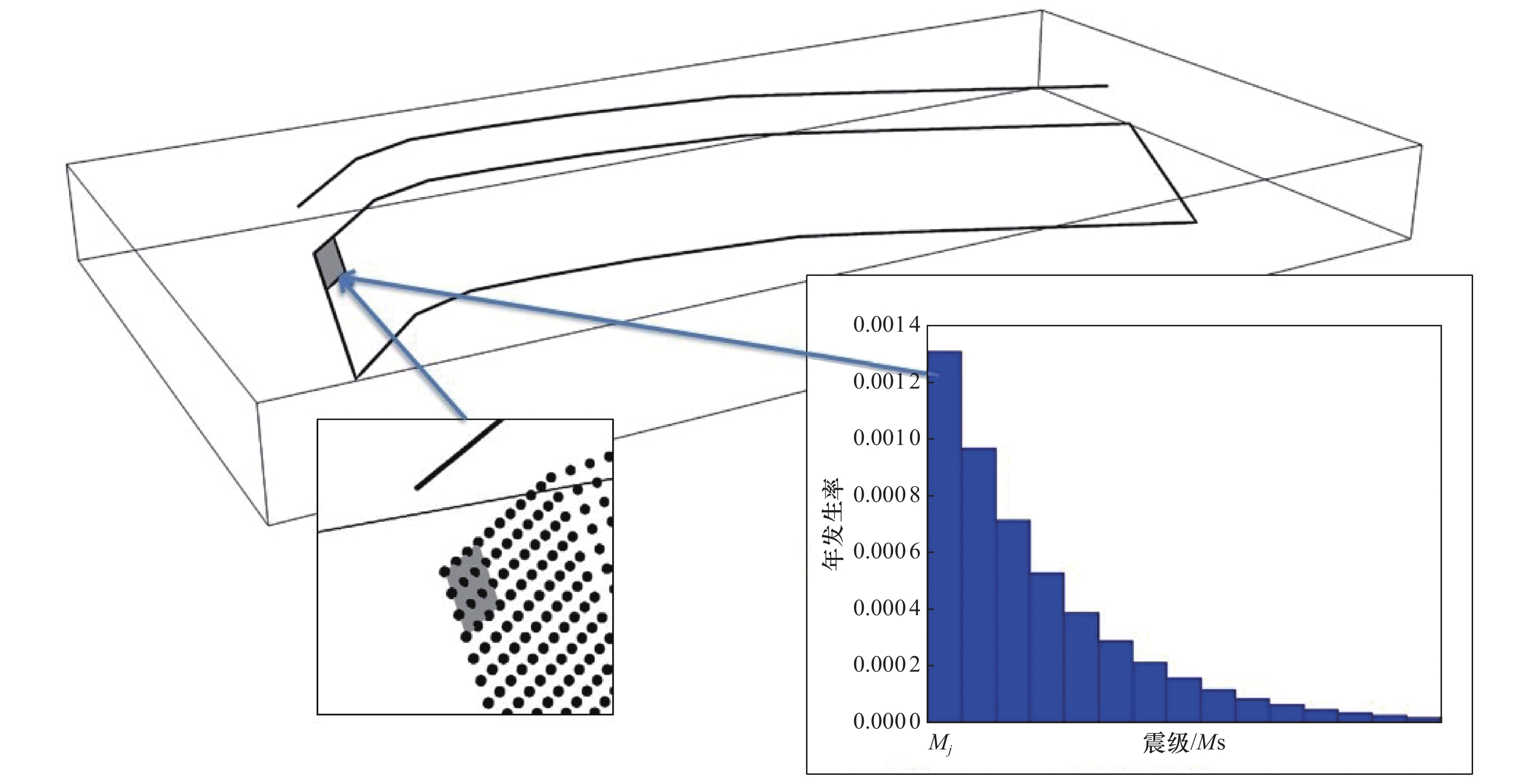
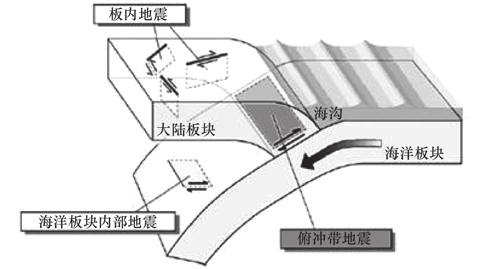
图 3 俯冲带潜源1个子源的Mj级地震产生的破裂面空间范围示意图
Figure 3. Spatial range of a rupture surface by a magnitude Mj earthquake on a subduction zone
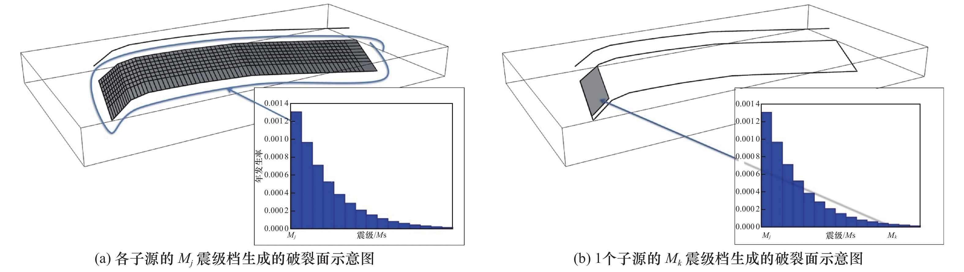
图 4 各子源生成破裂面原理示意图
Figure 4. Theory of rupture surfaces generating for each sub-sources of a source
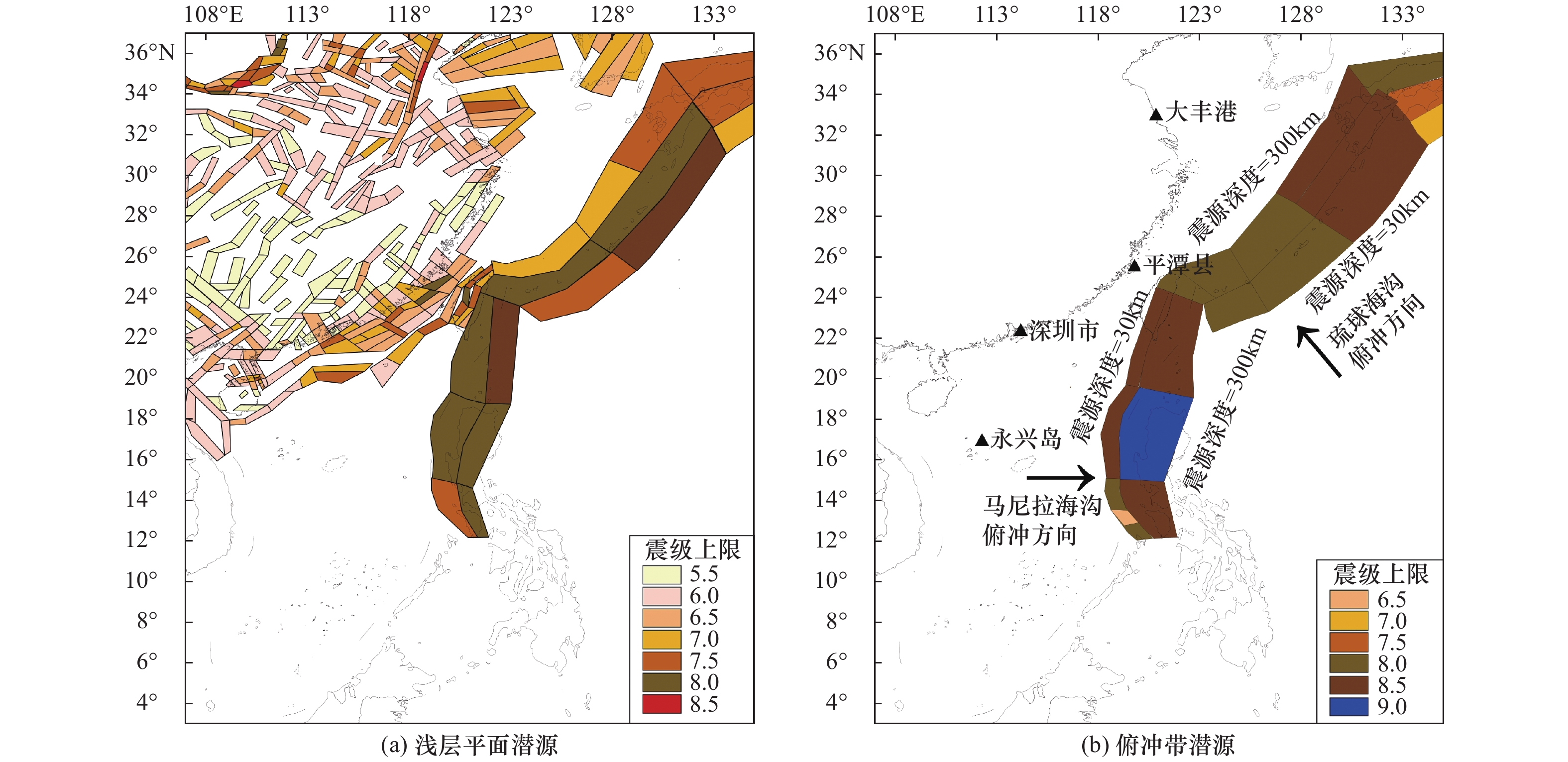
图 5 中国海域及邻区潜在震源区划分图
Figure 5. Seismogenic sources in Chinese oceanic area and surrounding areas
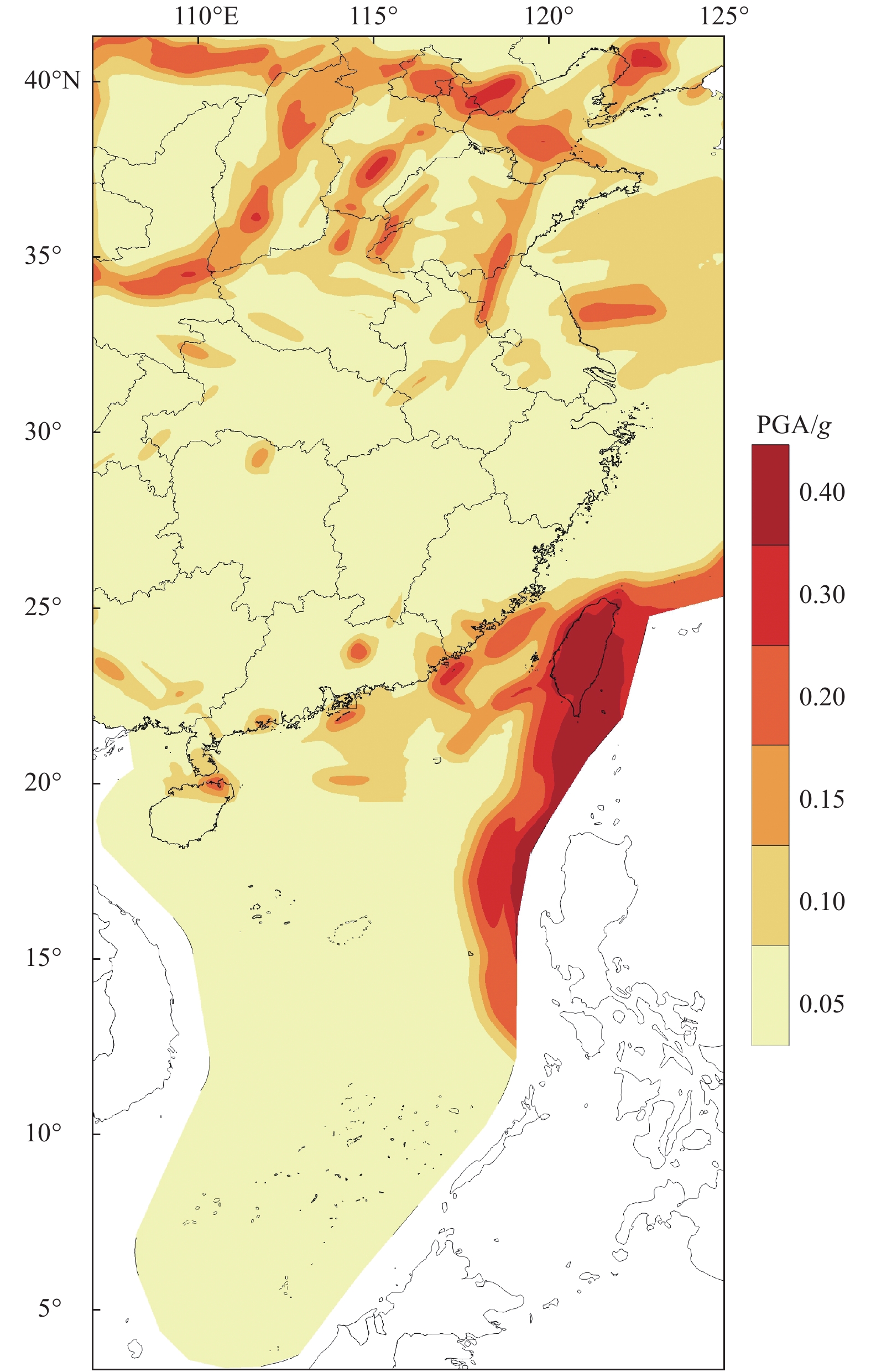
图 6 中国海域及邻区50年超越概率10%的PGA分布图
Figure 6. Map of PGA with 10% probability of exceedance in 50 years for Chinese oceanic area and surrounding areas
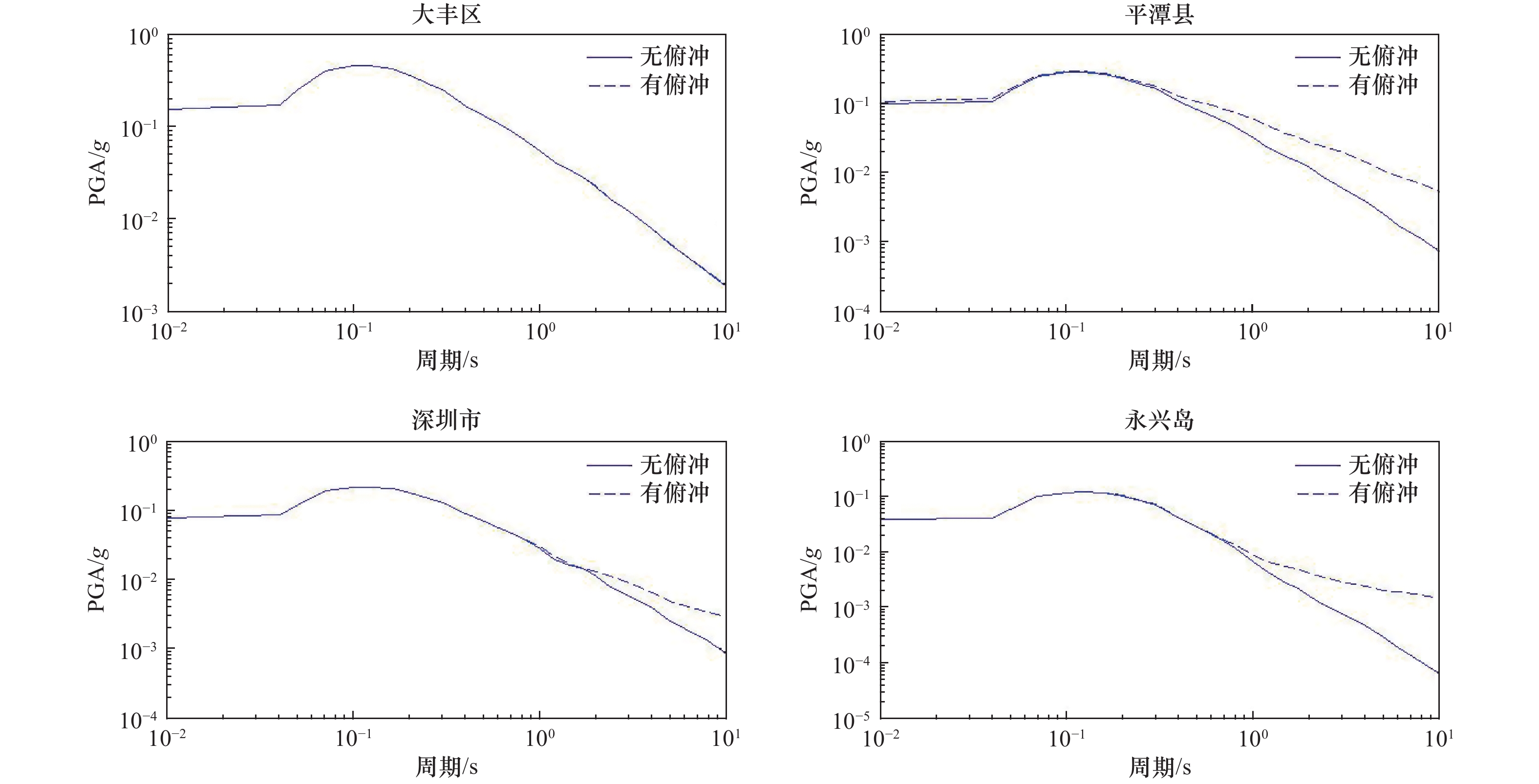
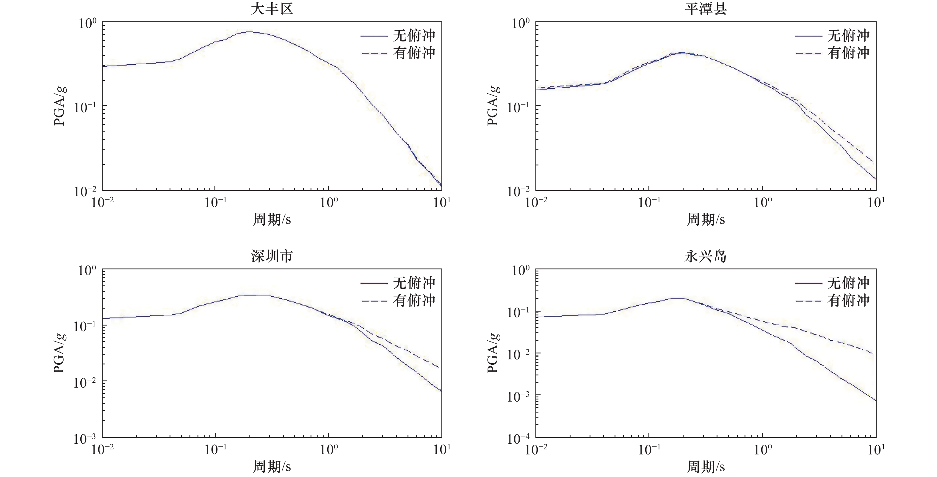
图 7 4个场点考虑和不考虑俯冲带潜在震源区的50年超越概率10%的地震动反应谱
Figure 7. Earthquake response spectrum with 10% probability of exceedance in 50 years considering and without subduction sources for the 4 sites
-
邓起东, 张裕明, 环文林等, 1980. 中国地震烈度区划图编制的原则和方法. 地震学报, 2(1): 90—110.Deng Q. D., Zhang Y. M., Huan W. L., et al., 1980. Principles and methods of composing the seismic zoning map of China. Acta Seismologica Sinica, 2(1): 90—110. (in Chinese) 地震调查研究推进本部地震委员会, 2018. 全国地震动预测地图2018年版. 东京: 地震调查研究推进本部事务局. 高孟潭, 2003. 新的国家地震区划图. 地震学报, 25(6): 630—636. doi: 10.3321/j.issn:0253-3782.2003.06.009Gao M. T., 2003. New national seismic zoning map of China. Acta Seismologica Sinica, 25(6): 630—636. (in Chinese) doi: 10.3321/j.issn:0253-3782.2003.06.009 李善邦, 1957. 中国地震区域划分圖及其說明Ⅰ. 总的說明. 地球物理学报, 6(2): 127—158.Li S. B., 1957. The map of seismicity of China. Chinese Journal of Geophysics, 6(2): 127—158. (in Chinese) 李小军, 胡进军, 陈苏等, 2020. 海域地震动传播规律及场地影响模型研究报告, 16—28. 北京: 中国地震局地球物理研究所. 吕悦军, 冉洪流, 徐伟进等, 2020. 海域地震活动性模型及其评价方法研究报告, 23—31. 北京: 应急管理部国家自然灾害防治研究院. 潘华, 高孟潭, 谢富仁, 2013. 新版地震区划图地震活动性模型与参数确定. 震灾防御技术, 8(1): 11—23. doi: 10.3969/j.issn.1673-5722.2013.01.002Pan H., Gao M. T., Xie F. R., 2013. The earthquake activity model and seismicity parameters in the new seismic hazard map of China. Technology for Earthquake Disaster Prevention, 8(1): 11—23. (in Chinese) doi: 10.3969/j.issn.1673-5722.2013.01.002 任治坤, 高战武, 李正芳等, 2020. 海域活动构造框架和地震构造模型研究报告, 18-24. 北京: 中国地震局地质研究所. 陶夏新, 1992. 我国新的地震区划编图和中国地震烈度区划图(1990). 自然灾害学报, 1(1): 99—109.Tao X. X., 1992. On the new national seismic zonation and the seismic intensity zoning map of China (1990). Journal of Natural Disasters, 1(1): 99—109. (in Chinese) 肖亮, 2019. 海域地震动预测方程模型研究报告, 8-12. 北京: 中国地震局地球物理研究所. 肖亮, 2020. 海域地震动传播规律及场地影响模型研究报告, 1—13. 北京: 中国地震局地球物理研究所. 俞言祥, 李山有, 肖亮, 2013. 为新区划图编制所建立的地震动衰减关系. 震灾防御技术, 8(1): 24—33. doi: 10.3969/j.issn.1673-5722.2013.01.003Yu Y. X., Li S. Y., Xiao L., 2013. Development of ground motion attenuation relations for the new seismic hazard map of China. Technology for Earthquake Disaster Prevention, 8(1): 24—33. (in Chinese) doi: 10.3969/j.issn.1673-5722.2013.01.003 中国地震烈度区划图编委会, 1992. 中国地震烈度区划图(1990)及其说明. 中国地震, 8(4): 1—11.The Compiling Committee of Seismic Zoning Map in China, 1992. Seismic intensity zoning map of China (1990) and its explanations. Earthquake Research in China, 8(4): 1—11. (in Chinese) 中华人民共和国国家质量监督检验检疫总局, 中国国家标准化管理委员会, 2016. GB 18306—2015 中国地震动参数区划图. 北京: 中国标准出版社.General Administration of Quality Supervision, Inspection and Quarantine of the People’s Republic of China, Standardization Administration, 2016. GB 18306-2015 Seismic ground motion parameters zonation map of China. Beijing: Standards Press of China. (in Chinese) 周本刚, 陈国星, 高战武, 等, 2013. 新地震区划图潜在震源区划分的主要技术特色. 震灾防御技术, 8(2): 113—124. doi: 10.3969/j.issn.1673-5722.2013.02.001Zhou B. G., Chen G. X., Gao Z. W., et al., 2013. The technical highlights in identifying the potential seismic sources for the update of national seismic zoning map of China. Technology for Earthquake Disaster Prevention, 8(2): 113—124. (in Chinese) doi: 10.3969/j.issn.1673-5722.2013.02.001 Cheng J., Rong Y. F., Magistrale H., et al., 2017. An mw-based historical earthquake catalog for mainland China. Bulletin of the Seismological Society of America, 107(5): 2490—2500. doi: 10.1785/0120170102 Cornell C. A., 1968. Engineering seismic risk analysis. Bulletin of the Seismological Society of America, 58(5): 1583—1606. Danciu L., Şeşetyan K., Demircioglu M., et al., 2018. The 2014 earthquake model of the middle east: seismogenic sources. Bulletin of Earthquake Engineering, 16(8): 3465—3496. doi: 10.1007/s10518-017-0096-8 Giardini D., Wössner J., Danciu L., 2014. Mapping Europe’s seismic hazard. EOS, Transactions, American Geophysical Union, 95(29): 261—262. Gutenberg B., Richter C. F., 1944. Frequency of earthquakes in California. Bulletin of the Seismological Society of America, 34(4): 185—188. McGuire R. K., 1995. Probabilistic seismic hazard analysis and design earthquakes: closing the loop. Bulletin of the Seismological Society of America, 85(5): 1275—1284. Petersen M. D., Moschetti M. P., Powers P. M., et al., 2015. The 2014 United States national seismic hazard model. Earthquake Spectra, 31(1S): S1—S30. Wells D. L., Coppersmith K. J., 1994. New empirical relationships among magnitude, rupture length, rupture width, rupture area, and surface displacement. Bulletin of the Seismological Society of America, 84(4): 974—1002. Woessner J., Laurentiu D., Giardini D., et al., 2015. The 2013 European seismic hazard model: key components and results. Bulletin of Earthquake Engineering, 13(12): 3553—3596. doi: 10.1007/s10518-015-9795-1 -

 下载:
下载:

 点击查看大图
计量
- 文章访问数: 126
- HTML全文浏览量: 70
- PDF下载量: 8
- 被引次数: 0
