
Research Progress of Seismogenic Zonation Model and Discussion on Seismogenic Zonation of Our and Nearby Sea Areas
-
摘要: 对于陆域地区,我国已进行5次全国范围大面积地震区划研究工作,获得了丰富研究成果。但对于海域地区地震区划的研究较薄弱,较少涉及海域潜源划分模型。随着经济发展,涉及海域地区的经济活动日益频繁,对海域地区潜源划分研究及进一步地震区划研究工作的需求越来越强烈。为此,详细介绍代表性国家在潜源划分方面采取的原则和方法,总结我国海域地区地震地质背景及相应的研究现状,并在此基础上提出我国海域地区潜源划分可考虑的原则和基本思路,为后续我国海域地区区划研究提供方案。Abstract: Currently, our China has finished 5 versions of national wide seismic zonation maps and obtained fruitful achievement. But the seismic zonation research on sea areas is very weak and little is involved in seismogenic zonation model. Along with the development of Chinese economy, economic activity in sea areas is more and more frequent, which leads increasingly strong requirement on seismogenic zonation research and further seismic zonation research. This research introduces the current principles and methods adopted by typical countries and regions in the world, such as China, America, Europe, New Zealand and Southeast Asia area, Then seismic geologic background and corresponding research situation of sea areas in China have been summarized and analyzed, and on the base of that, we further propose a considerable principle and method of sea area in China, which provides a scheme for subsequent seismic zonation research on sea area in China.
-
Key words:
- Seismogenic source model /
- Sea area /
- Current research situation /
- Zonation principle
-
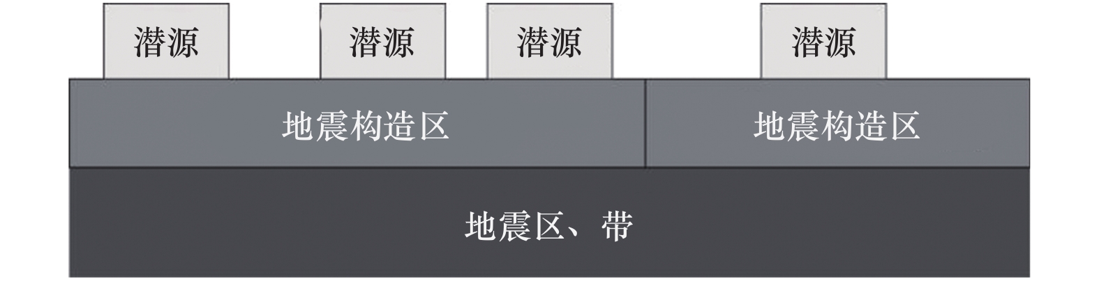
图 1 五代图三级潜源空间关系示意图
Figure 1. Spatial relationship sketch map of three levels of potential seismic sources in 5th Version Seismic zonation map
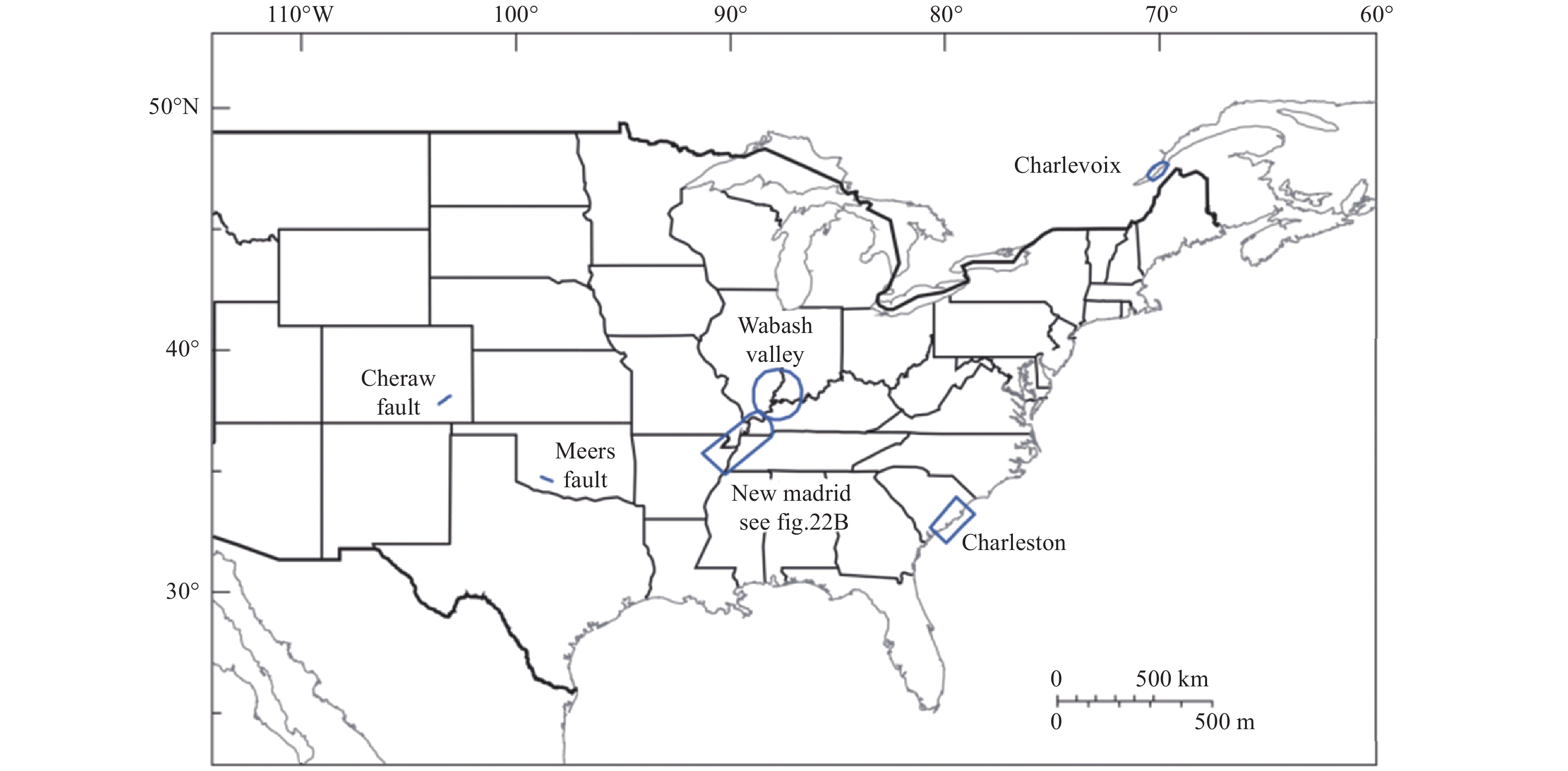
图 2 美国中东部地区基于断裂的潜源分布(Petersen等,2014)
Figure 2. Potential Seismic sources distribution map on the base of faults in Middle and East America(Petersen et al,2014)
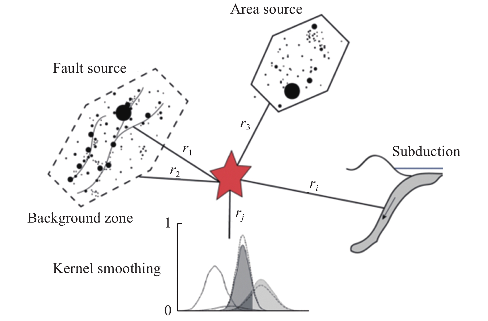
图 3 2013年版欧洲地区地震危险性模型采用的潜源数据示意图
Figure 3. Sketch diagram of four potential seismic sources
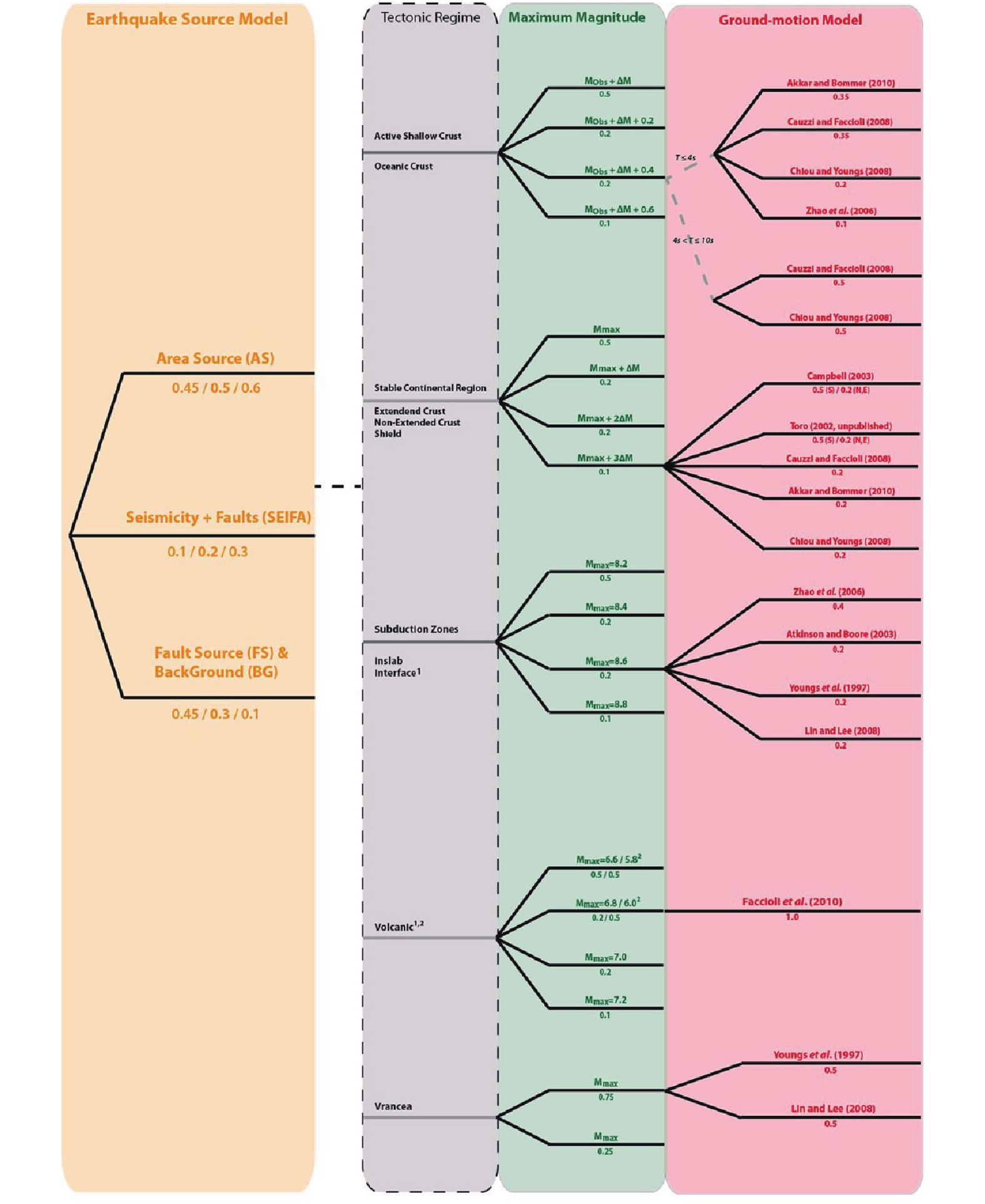
图 4 欧洲地区地震危险性统一化工程(SHARE)逻辑树
Figure 4. The logic tree of Seismic Hazard Harmonization in Europe (SHARE)
-
[1] 李小军, 2006. 海域工程场地地震安全性评价的特殊问题. 震灾防御技术, 1(2): 97-104. doi: 10.3969/j.issn.1673-5722.2006.02.002Li X. J., 2006. Special problems on evaluation of seismic safety for offshore engineering site. Technology for Earthquake Disaster Prevention, 1(2): 97-104. (in Chinese) doi: 10.3969/j.issn.1673-5722.2006.02.002 [2] 李小军, 陈苏, 任治坤等, 2020. 海域地震区划关键技术研究项目及研究进展. 地震科学进展, 50(1): 2-19. doi: 10.3969/j.issn.2096-7780.2020.01.001Li X. J., Chen S., Ren Z. K., et al., 2020. Project plan and research progress on key technologies of seismic zoning in sea areas. Progress in Earthquake Sciences, 50(1): 2-19. (in Chinese) doi: 10.3969/j.issn.2096-7780.2020.01.001 [3] 刘光鼎, 1990. 中国海大地构造演化. 石油与天然气地质, 11(1): 23-29. doi: 10.11743/ogg19900103Liu G. D., 1990. Tectonic evolution of China seas. Oil & Gas Geology, 11(1): 23-29. (in Chinese) doi: 10.11743/ogg19900103 [4] 罗华春, 任志林, 刘影, 2016. 中国地震区划图发展历程简介. 城市与减灾, (3), 12-17. doi: 10.3969/j.issn.1671-0495.2016.03.005 [5] 孟祥君, 张训华, 2009. 中国东部海区及邻域磁场特征. 见: 中国地球物理·2009. 合肥, 中国: 中国科学技术大学出版社. [6] 潘华, 高孟潭, 李金臣, 2009. 新版美国地震区划图源及其参数模型的分析与评述. 震灾防御技术, 4(2): 131-140. doi: 10.3969/j.issn.1673-5722.2009.02.001Pan H., Gao M. T., Li J. C., 2009. Comments on the models of seismic source and parameters used in the new edition of United States national seismic hazard maps. Technology for Earthquake Disaster Prevention, 4(2): 131-140. (in Chinese) doi: 10.3969/j.issn.1673-5722.2009.02.001 [7] 潘华, 高孟潭, 谢富仁, 2013. 新版地震区划图地震活动性模型与参数确定. 震灾防御技术, 8(1): 11-23. doi: 10.3969/j.issn.1673-5722.2013.01.002Pan H., Gao M. T., Xie F. R., 2013. The earthquake activity model and seismicity parameters in the new seismic hazard map of China. Technology for Earthquake Disaster Prevention, 8(1): 11-23. (in Chinese) doi: 10.3969/j.issn.1673-5722.2013.01.002 [8] 潘华, 张萌, 李金臣, 2017. 美国地震区划图的发展--地震危险性图与抗震设计图. 震灾防御技术, 12(3): 511-522. doi: 10.11899/zzfy20170307Pan H., Zhang M., Li J. C., 2017. Review of seismic zonation in United States, Seismic hazard maps and seismic design maps. Technology for Earthquake Disaster Prevention, 12(3): 511-522. (in Chinese) doi: 10.11899/zzfy20170307 [9] 塔金璐, 2014. 渤黄海粘土粒级沉积物地球化学记录对物源和沉积环境的释读. 青岛: 中国海洋大学.Ta J. L., 2014. Geochemical records of clay-grain size sediments and their implications for the provenance and sedimentary environments in Bohai Sea and Yellow Sea. Qingdao: Ocean University of China. (in Chinese) [10] 陶夏新, 1992. 我国新的地震区划编图和中国地震烈度区划图(1990). 自然灾害学报, 1(1): 99-109.Tao X. X., 1992. On the new national seismic zonation and the seismic intensity zoning map of China (1990). Journal of Natural Disasters, 1(1): 99-109. (in Chinese) [11] 吴果, 2014. 基于多模型的概率地震危险性分析方法实例研究. 北京: 中国地震局地质研究所.Wu G., 2014. Case study of probabilistic seismic hazard analysis method based on multi-model. Beijing: Institute of Geology, China Earthquake Administration. (in Chinese) [12] 周本刚, 陈国星, 高战武等, 2013. 新地震区划图潜在震源区划分的主要技术特色. 震灾防御技术, 8(2): 113-124. doi: 10.3969/j.issn.1673-5722.2013.02.001Zhou B. G., Chen G. X., Gao Z. W., et al., 2013. The technical highlights in identifying the potential seismic sources for the update of national seismic zoning map of China. Technology for Earthquake Disaster Prevention, 8(2): 113-124. (in Chinese) doi: 10.3969/j.issn.1673-5722.2013.02.001 [13] Basili R., Tiberti M. M., Kastelic V, et al., 2013. Integrating geologic fault data into tsunami hazard studies. Natural Hazards and Earth System Sciences, 13(4): 1025-1050. doi: 10.5194/nhess-13-1025-2013 [14] Coppersmith K. J., Salomone L. A., Fuller C. W., et al., 2012. Central and Eastern United States (CEUS) Seismic Source Characterization (SSC) for nuclear facilities project. Charlotte: Electric Power Research Institute. [15] Cornell C. A., 1968. Engineering seismic risk analysis. Bulletin of the Seismological Society of America, 58(5): 1583-1606. [16] Engdahl E. R., van der Hilst R., Buland R., 1998. Global teleseismic earthquake relocation with improved travel times and procedures for depth determination. Bulletin of the Seismological Society of America, 88(3): 722-743. [17] Engdahl E. R., Villaseñor A., 2002. Global seismicity: 1900-1999. International Geophysics, 81: 665-690, cp1-cp2. [18] Frankel A., Mueller C., Barnhard T., et al., 1996. National seismic-hazard maps: documentation June 1996. Denver, CO: U.S. Geological Survey. [19] Frankel A. D., Petersen M. D., Mueller C. S., et al., 2002. Documentation for the 2002 update of the national seismic hazard maps. Denver: U.S. Geological Survey. [20] Grützner C., Carson E., Walker R. T., et al., 2017. Assessing the activity of faults in continental interiors: palaeoseismic insights from SE Kazakhstan. Earth and Planetary Science Letters, 459: 93-104. doi: 10.1016/j.jpgl.2016.11.025 [21] Gutenberg B., Richter C. F., 1944. Frequency of earthquakes in California. Bulletin of the Seismological Society of America, 34(4): 185-188. doi: 10.1785/BSSA0340040185 [22] Petersen M., Harmsen S., Mueller C., et al., 2007. Documentation for the Southeast Asia seismic hazard maps. Reston: U.S. Geological Survey. [23] Petersen M. D., Harmsen S., Mueller C., et al., 2008a. Probabilistic seismic hazard for southeast Asia. In: International Conference of Earthquake Engineering and Disaster Mitigation. Jakarta. [24] Petersen M. D., Frankel A. D., Harmsen S. C., et al., 2008b. Documentation for the 2008 update of the United States national seismic hazard maps. Reston: U.S. Geological Survey. [25] Petersen M. D., Moschetti M. P., Powers P. M., et al., 2014. Documentation for the 2014 update of the United States national seismic hazard maps. Reston: U.S. Geological Survey. [26] Petersen M. D., Shumway A. M., Powers P. M., et al., 2020. The 2018 update of the US national seismic hazard model: overview of model and implications. Earthquake Spectra, 36(1): 5-41. doi: 10.1177/8755293019878199 [27] Rangin C., Le Pichon X., Mazzotti S., et al., 1999. Plate convergence measured by GPS across the Sundaland/Philippine Sea plate deformed boundary: the Philippines and eastern Indonesia. Geophysical Journal International, 139(2): 296-316. doi: 10.1046/j.1365-246x.1999.00969.x [28] Rikitake T., 1976. Recurrence of great earthquakes at subduction zones. Tectonophysics, 35(4): 335-362. doi: 10.1016/0040-1951(76)90075-5 [29] Stein S., Okal E. A., 2005. Seismology: speed and size of the Sumatra earthquake. Nature, 434(7033): 581-582. doi: 10.1038/434581a [30] Stirling M., McVerry G., Gerstenberger M., et al., 2012. National seismic hazard model for New Zealand: 2010 update. Bulletin of the Seismological Society of America, 102(4): 1514-1542. doi: 10.1785/0120110170 [31] Stirling M. W., Verry G. H. M., Berryman K. R., 2002. A new seismic hazard model for New Zealand. Bulletin of the Seismological Society of America, 92(5): 1878-1903. doi: 10.1785/0120010156 [32] Stock C., Smith E. G. C., 2002. Adaptive kernel estimation and continuous probability representation of historical earthquake catalogs. Bulletin of the Seismological Society of America, 92(3): 904-912. doi: 10.1785/0120000233 [33] Wells D. L., Coppersmith K. J., 1994. New empirical relationships among magnitude, rupture length, rupture width, rupture area, and surface displacement. Bulletin of the Seismological Society of America, 84(4): 974-1002. [34] Werner M. J., Helmstetter A., Jackson D. D., et al., 2011. High-resolution long-term and short-term earthquake forecasts for California. Bulletin of the Seismological Society of America, 101(4): 1630-1648. doi: 10.1785/0120090340 [35] Woessner J., Laurentiu D., Giardini D., et al., 2015. The 2013 European seismic hazard model: key components and results. Bulletin of Earthquake Engineering, 13(12): 3553-3596. doi: 10.1007/s10518-015-9795-1 [36] Zhao D. P., Fujisawa M. Toyokuni G., 2017. Tomography of the subducting Pacific slab and the 2015 Bonin deepest earthquake (Mw 7.9). Scientific Reports, 7: 44487. doi: 10.1038/srep44487 -

 下载:
下载:
 点击查看大图
计量
- 文章访问数: 364
- HTML全文浏览量: 61
- PDF下载量: 41
- 被引次数: 0
