
Quaternary Activity Characteristics of the Coastal Fault Zone in Eastern Guangdong
-
摘要: 我国东南沿海滨海断裂带是1条活动强烈的地震构造带,位于珠江口盆地北缘的粤东滨海断裂带是其重要组成部分,确定该断裂带的几何展布位置与最新活动特征对科学评价华南沿海地区地震危险性、地震构造和地球动力学具有重要科学意义。通过综合分析近年来南海东北部海域地质地貌、地震反射剖面、深部探测、地震活动等方面的研究成果,总结了粤东滨海断裂带几何结构与分段活动性,研究成果已应用于粤东沿海重大工程选址和地震区划工作中。Abstract: The Coastal Fault Zone along the southeast coast of China is a strong active seismic tectonic zone, and the Coastal Fault Zone in eastern Guangdong, located in the northern margin of the Pearl River Mouth Basin, is the basin’s important components. The determination of its geometric distribution and the latest active characteristics is of great scientific significance for the correct evaluation of seismic risk, seismic tectonics and geodynamics along the coast of South China. Based on the comprehensive analysis of the research results of geological geomorphology, seismic reflection profile, deep exploration and seismicity in the northern South China Sea in recent years, combined with the characteristics of deep structure, the geometric structure and segmented activity of the coastal fault zone in eastern Guangdong are determined. The results have been applied to the coastal site selection and seismic regionalization of major projects in eastern Guangdong.
-
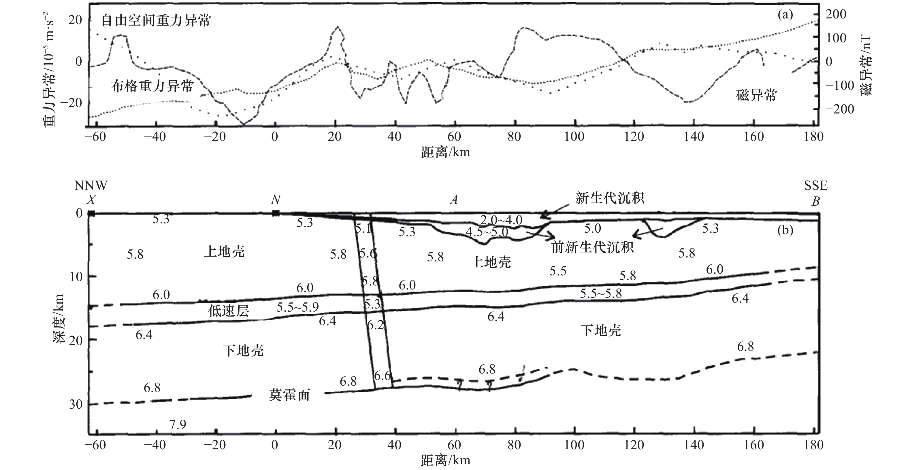
图 1 南海东北部海陆联测滨海断裂带地球物理特征剖面及地壳结构剖面
Figure 1. Geophysical profile (upper) and crustal structure profile (lowwer) of the coastal fault zone from land Sea joint survey in the northeast of the South China Sea
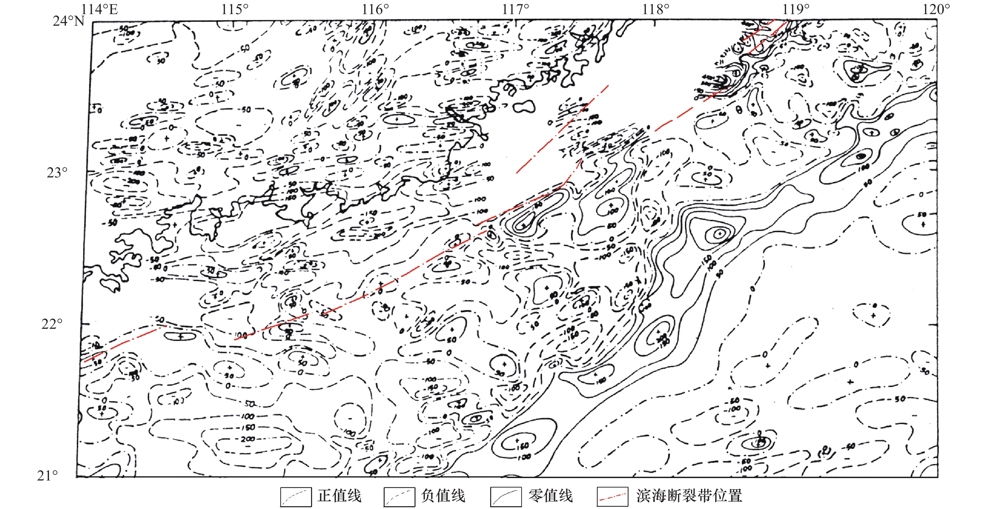
图 2 南海东北部磁异常平面图
Figure 2. Plane map of magnetic anomaly (Δ T) in northeastern South China Sea (isoline unit: NT)
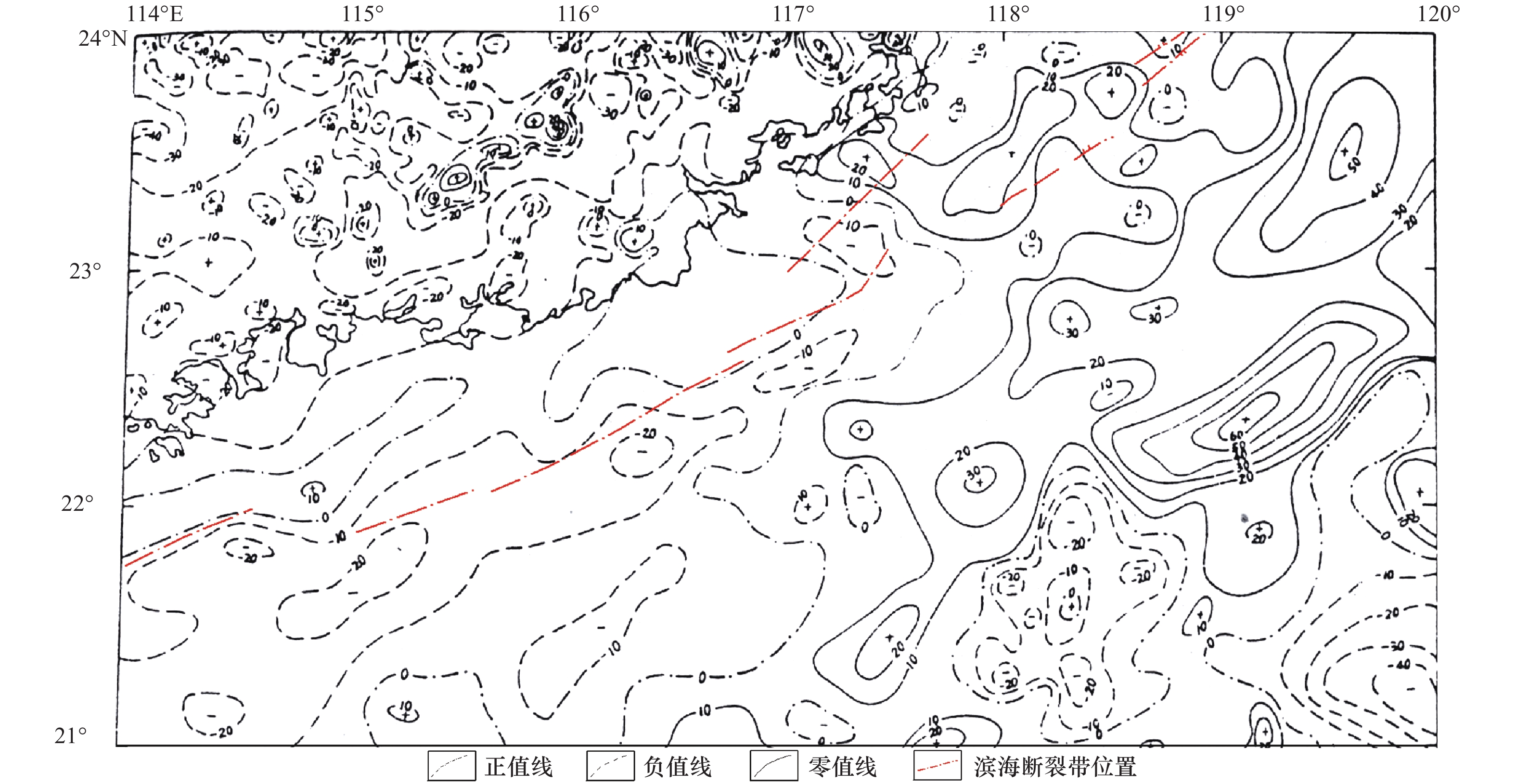
图 3 南海东北部空间重力异常图
Figure 3. Spatial gravity anomaly map of northeast South China Sea (isoline unit: MgAl)
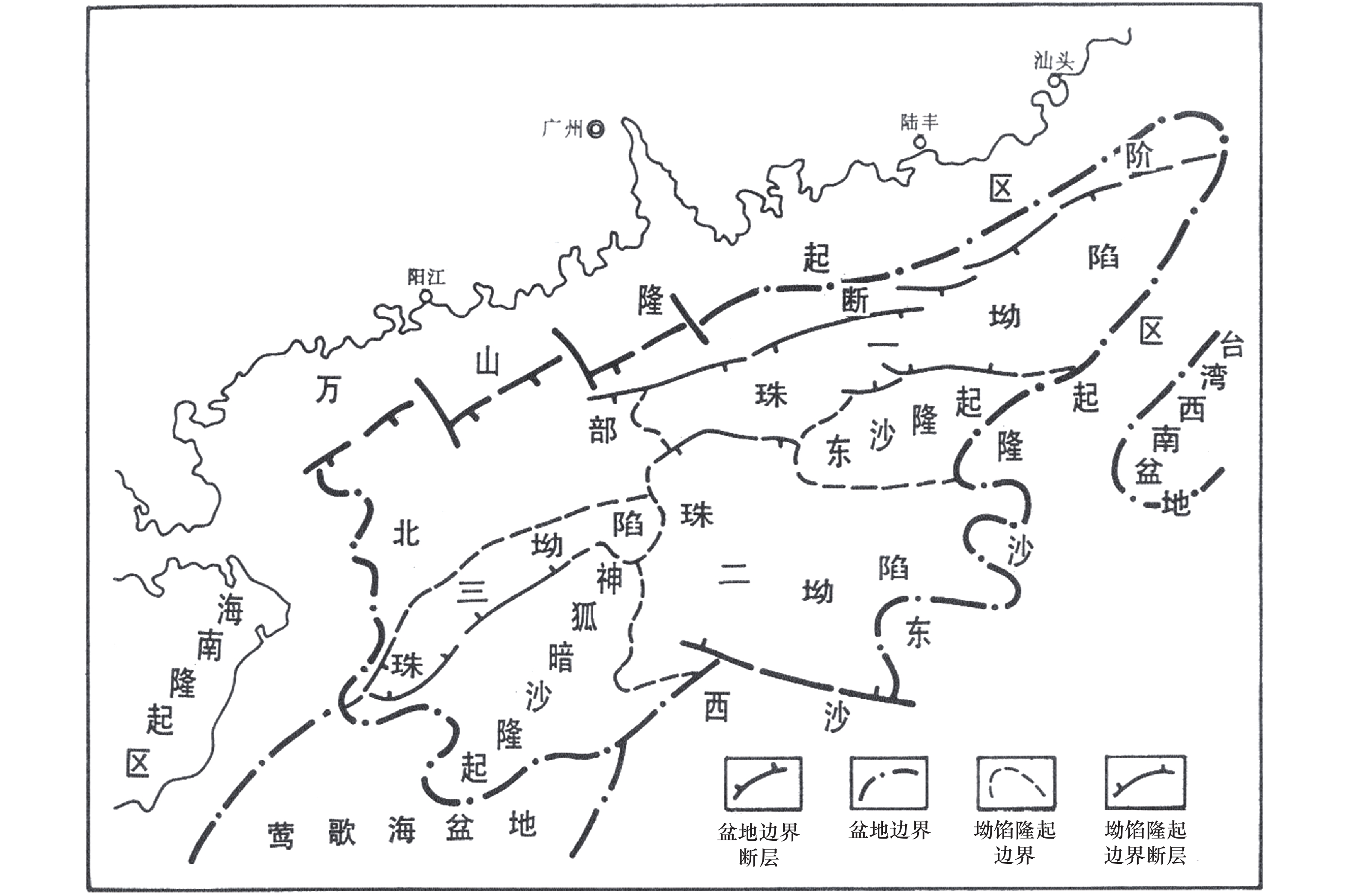
图 4 珠江口盆地新构造单元划分示意图
Figure 4. Division of Neotectonic units in the Pearl River Mouth Basin
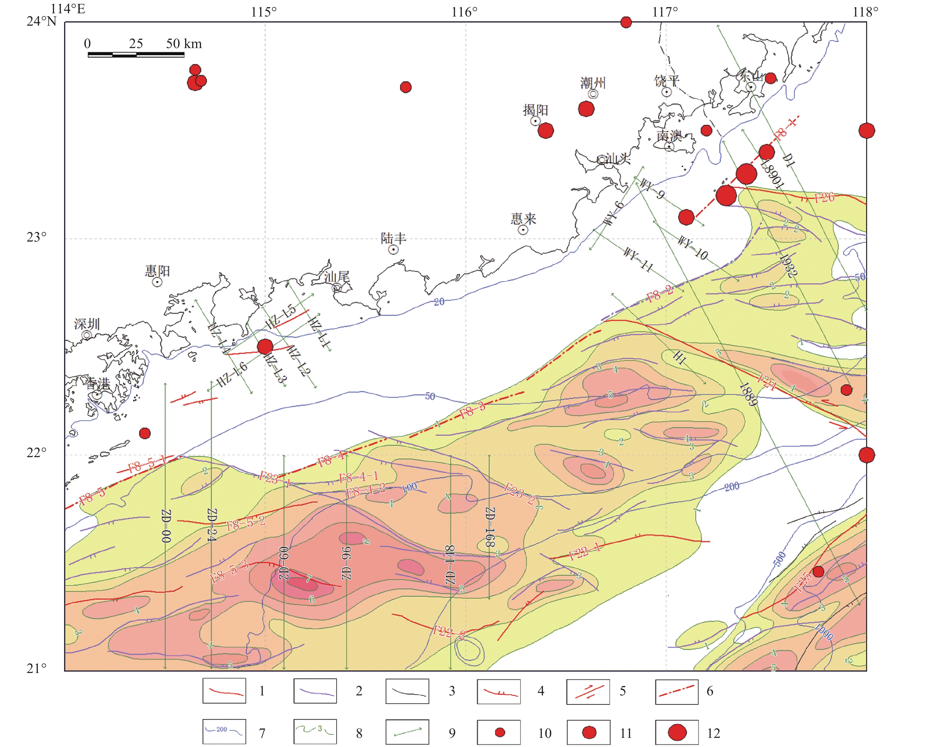
图 5 粤东滨海断裂带及地震勘探剖面位置示意图
1—晚第四纪活动断裂;2—早第四纪断裂;3—前第四纪断裂;4—正断层;5—走滑断层;6—滨海深断裂位置;7—海水等深线(m);8—新生界等厚线(km);9—地震勘探剖面位置;10—M=5~5.9;11—M=6~6.9;12—M=7~7.9;F8-1—滨海断裂带南澳海外段;F8-2—滨海断裂带汕头海外段;F8-3—滨海断裂带陆丰海外段;F8-4—滨海断裂带汕尾海外段;F22—珠一坳陷南缘断裂带;F23—珠一坳陷中部断裂带;F24—台湾浅滩西南断裂带;F25—东沙东南断裂带;F26—南澎岛外断裂
Figure 5. Location of coastal fault zone and seismic exploration section in eastern Guangdong
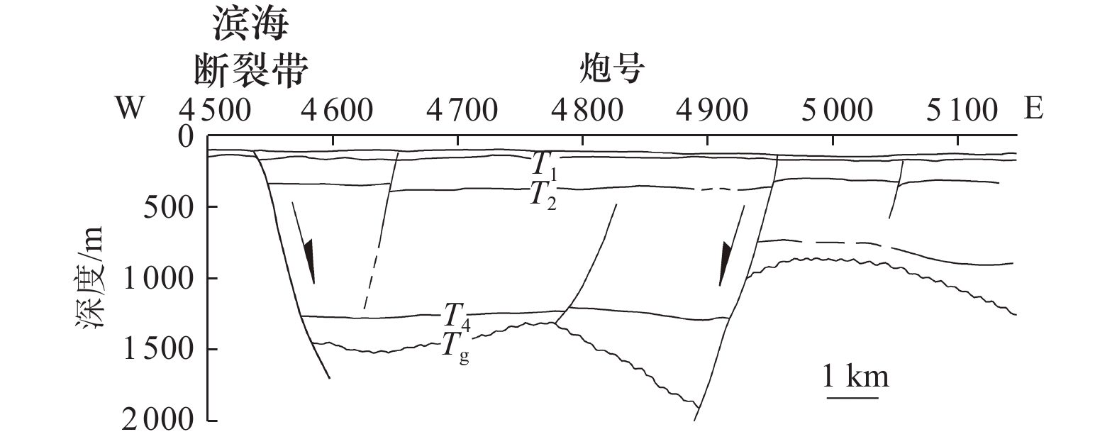
图 6 粤东韩江口外1932号人工地震反射剖面
反射界面:T1-N2至N13地层,T2-N13至N12地层,T4-N12至N11地层,Tg-E1至前第三纪地层或岩体
Figure 6. No. 1932 artificial seismic reflection profile outside hanjiangkou, eastern Guangdong
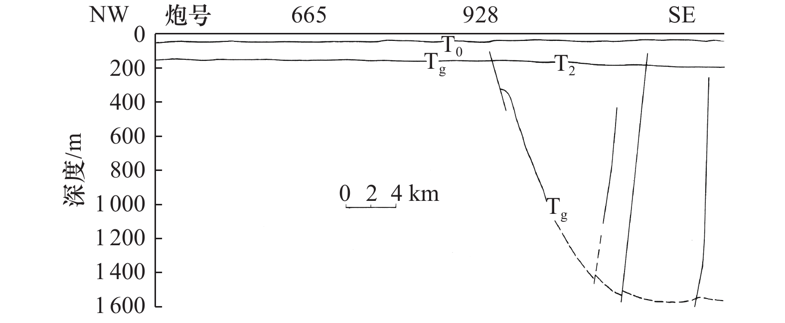
图 7 L8901号人工地震反射剖面
反射界面:T2-Q4至N2地层,Tg-E32至N1地层或岩体
Figure 7. No. L8901 artificial seismic reflection profile

图 8 汕头海外1889号人工地震反射剖面(局部)
反射界面:T1-N2至N13地层,T2-N13至N12地层,Tg-E1至前第三纪地层或岩体
Figure 8. No. 1889 artificial seismic reflection profile of Shantou overseas (local)
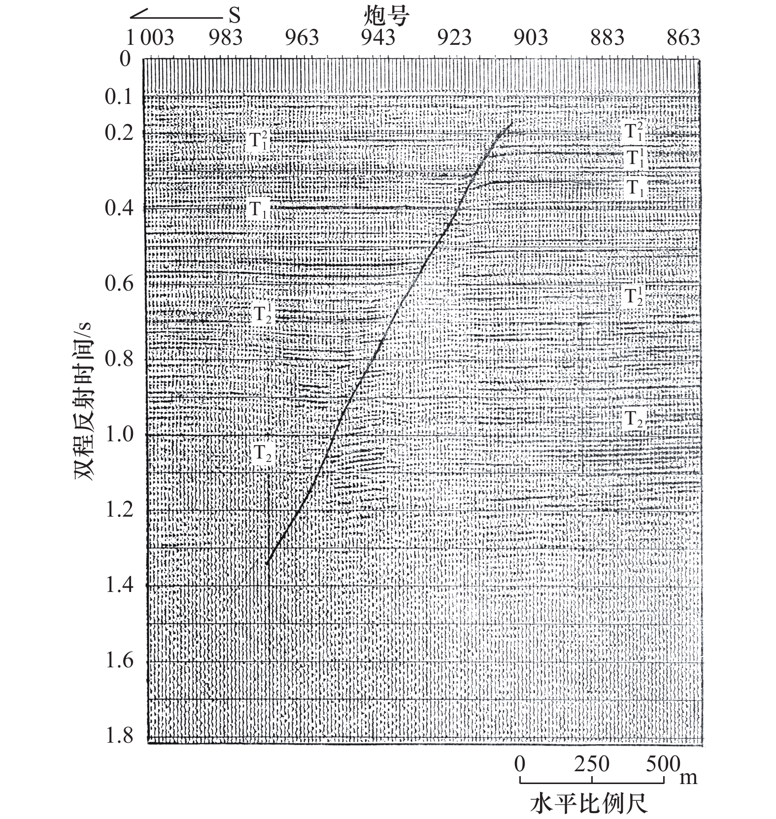
图 9 多道地震测线ZD-60显示的F8-4-1断裂
Figure 9. F8-4-1fault revealed by multi-channel seismic line zd-60

图 10 ZD-60测线单道、多道地震解释剖面
Figure 10. Single channel and multi channel seismic interpretation profiles of the zd-60 line
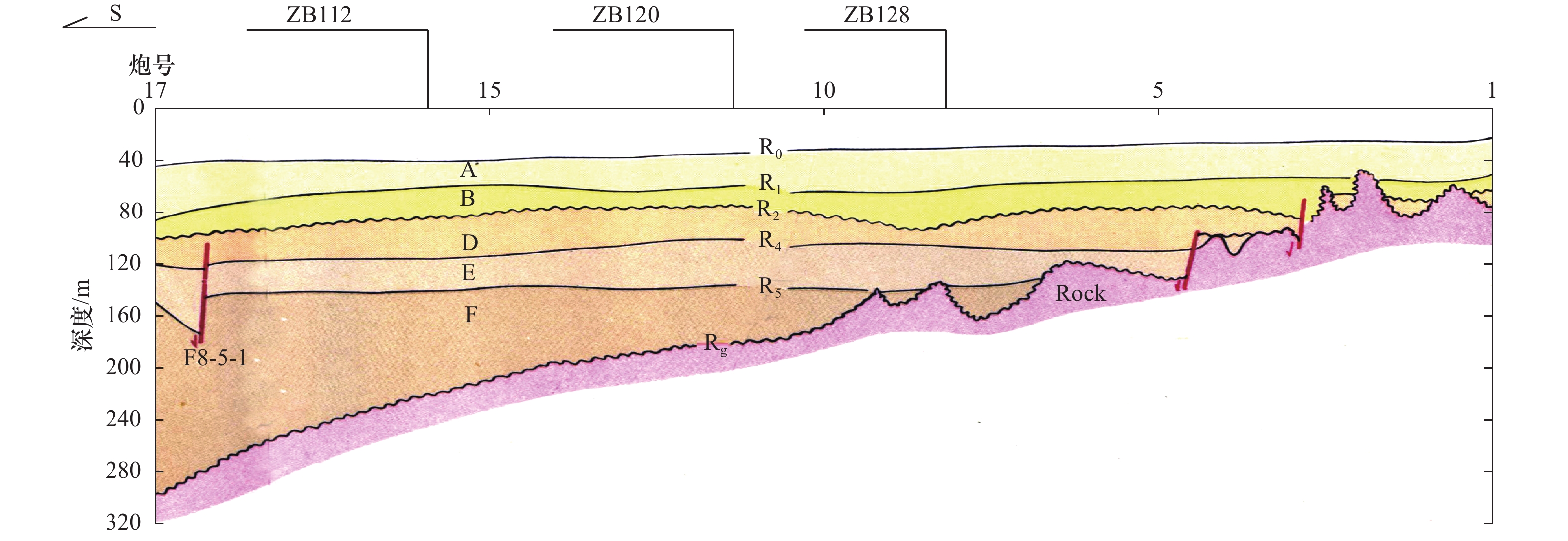
图 11 ZD00测线单道地震解释剖面
Figure 11. Single channel seismic interpretation profile of the zd-00 line
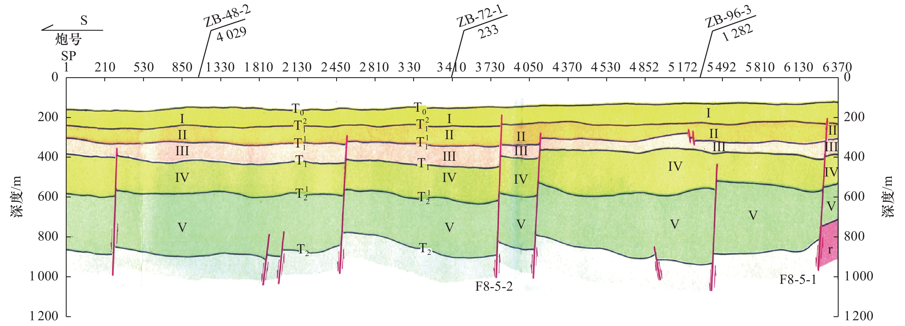
图 12 ZD00测线多道地震解释剖面
Figure 12. Multi -channel seismic interpretation profile of the zd-00 line
表 1 珠江口盆地第四纪层序划分与地震反射界面对比表
Table 1. Quaternary sequence division and seismic reflection interface correlation in the Pearl River Mouth Basin

 下载: 导出CSV
-
[1] 陈恩民, 黄咏茵, 1984. 华南十九次强震暨南海北部陆缘地震带概述. 华南地震, 4(1): 11—32. [2] 丁原章, 黄新辉, 1995. 华南滨海断裂带地震危险性的数学模拟. 华南地震, 15(1): 12—20.Ding Y. Z., Huang X. H., 1995. Mathemetial simulation after the seismic risk on the Coastal Fault Zone in the South China Sea. South China Journal of Seismology, 15(1): 12—20. (in Chinese) [3] 地质矿产部第二海洋地质调查大队, 1990. 南海珠江口盆地海洋工程地质调查报告(1∶20万).The Second Marine Geology Group of the Ministry of Geology and Mineral Resources, 1990. Marine engineering geological survey report (1∶ 200000) of the Pearl River Mouth Basin, South China Sea. [4] 国土资源部广州海洋地质调查局, 1999. 汕头幅(1∶ 100万)海洋区域地质调查与编图报告.Guangzhou Marine Geological Survey, 1999. Marine regional geological survey of the Shantou sheet (1∶1000000). [5] 郝天珧, 徐亚, 孙福利等, 2011. 南海共轭大陆边缘构造属性的综合地球物理研究. 地球物理学报, 54(12): 3098—3116. doi: 10.3969/j.issn.0001-5733.2011.12.011Hao T. Y., Xu Y., Sun F. L., et al., 2011. Integrated geophysical research on the tectonic attribute of conjugate continental margin of South China Sea. Chinese Journal of Geophysics, 54(12): 3098—3116. (in Chinese) doi: 10.3969/j.issn.0001-5733.2011.12.011 [6] 李唐根等, 1992. 南海大地构造特征. 见: 刘光鼎主编, 中国海区及邻域地质地球物理特征. 北京: 科学出版社, 248—271. [7] 梁德华, 1982. 试论南海系. 海洋地质研究, 2(4): 34—41.Liang D. H., 1982. On the Nanhai system. Marine Geological Research, 2(4): 34—41. (in Chinese) [8] 刘光鼎, 1992. 中国海区及邻域地质地球物理特征. 北京: 科学出版社.Liu G. D., ed., 1992. Geologic-geophysic features of China seas and adjacent regions. Beijing: Science Press. (in Chinese) [9] 刘以宣, 1981. 华南沿海区域断裂构造分析. 北京: 地震出版社. [10] 栾锡武, 刘鸿, 彭学超, 2011. 南海北部东沙古隆起的综合地球物理解释. 地球物理学报, 54(12): 3217—3232. doi: 10.3969/j.issn.0001-5733.2011.12.021Luan X. W., Liu H., Peng X. C., 2011. The geophysical interpretation of a Dongsha ancient uplift on the northern margin of South China Sea. Chinese Journal of Geophysics, 54(12): 3217—3232. (in Chinese) doi: 10.3969/j.issn.0001-5733.2011.12.021 [11] Nissen S. S., Hayes D. E., Buhl P., et al., 1995. Deep penetration seismic soundings across the northern margin of the South China Sea. Journal of Geophysical Research: Solid Earth, 100(B11): 22407—22433. doi: 10.1029/95JB01866 [12] 丘学林, 赵明辉, 叶春明等, 2003. 南海东北部海陆联测与海底地震仪探测. 大地构造与成矿学, 27(4): 295—300. doi: 10.3969/j.issn.1001-1552.2003.04.001Qiu X. L., Zhao M. H., Ye C. M., et al., 2003. Ocean bottom seismometer and onshore-offshore seismic experiment in northeastern South China Sea. Geotectonica et Metallogenia, 27(4): 295—300. (in Chinese) doi: 10.3969/j.issn.1001-1552.2003.04.001 [13] 魏柏林, 2000. 广东省地震构造图集. 北京: 地震出版社.Wei B. L., 2000. The seismotectonic atlas of Guangdong province. Beijing: Seismological Press. (in Chinese) [14] 魏柏林, 2001. 东南沿海地震活动特征. 北京: 地震出版社. [15] 龚再升, 王善书主编, 1992. 中国石油地质志(十六卷)——沿海大陆架及毗邻海域油气区(下册). 北京: 石油工业出版社.Gong Z.S., Wang S. S., eds., 1992. Petroleum geology of China Vol. 16-Oil and gas bearing areas on continental shelf and its neighboring regions. Beijing: Petroleum Industry Press. (in Chinese) [16] 詹文欢, 钟建强, 1996. 华南滨海断裂带活动区段的划分及其对沿海经济开发区的影响. 南海研究与开发, (3): 1—7. [17] 赵明辉, 丘学林, 夏戡原等, 2003. 南海东北部滨海断裂带的研究现状与展望. 华南地震, 23(1): 20—27. doi: 10.3969/j.issn.1001-8662.2003.01.004Zhao M. H., Qiu X. L., Xia K. Y., et al., 2003. The situation and prospect of the research on the Binhai fault of NE South China Sea. South China Journal of Seismology, 23(1): 20—27. (in Chinese) doi: 10.3969/j.issn.1001-8662.2003.01.004 [18] 赵明辉, 丘学林, 叶春明等, 2004. 南海东北部海陆深地震联测与滨海断裂带两侧地壳结构分析. 地球物理学报, 47(5): 845—852. doi: 10.3321/j.issn:0001-5733.2004.05.016Zhao M. H., Qiu X. L., Ye C. M., et al., 2004. Analysis on deep crustal structure along the onshore-offshore seismic profile across the Binhai (Littoral) fault zone in northeastern South China Sea. Chinese Journal of Geophysics, 47(5): 845—852. (in Chinese) doi: 10.3321/j.issn:0001-5733.2004.05.016 [19] 中国科学院南海海洋研究所, 福建海洋研究所, 1989. 台湾海峡西部石油地质地球物理调查研究. 北京: 海洋出版社.South China Sea Institute of Oceanology, Chinese Academy of Sciences, Fujian Institute of Oceanography, 1989. The investigation and study on petroleum geology and geophysics in the Western Taiwan Strait. Beijing: China Ocean Press. (in Chinese) [20] Chen A. T., Nakamura Y., 1998. Velocity structure beneath eastern off shore of southern Taiwan based on OBS data and its tectonic significance. TAO, 9(3): 409—424. -

 点击查看大图
计量
- 文章访问数: 1059
- HTML全文浏览量: 140
- PDF下载量: 95
- 被引次数: 0
