
Application of Ground Penetrating Radar in Fault Detection of the Wulashan Piedmont Fault
-
摘要: 地质雷达是利用电磁波对地下不同电性介质进行探测的地球物理仪器,其探测速率快、分辨率高,可弥补探槽和其他地球物理方法存在探测盲区的缺陷,正在越来越多地应用于活动断层探测领域。本文以乌拉山山前断裂为例开展地质雷达探测工作,使用无人机正射影像技术对测线进行地形校正,获得断层浅部地质雷达图像。研究结果表明,本文研究方法能有效反映探槽揭露的地层单元和断层分布。本次探测中,雷达波形图像特征为:浅地表的土壤层反射波总体较弱;粗粒沉积为主的砾石层反射波总体较强,同相轴连续性好;细粒沉积为主的砂层反射波弱于砾石层,波形以中、高频为主,同相轴具有弱连续性;对于洪冲积地区,地质雷达能分辨具有一定特征的地层单元,这为剖面图像的断层识别提供了标志;通过无人机正射影像技术对地质雷达测线进行地形校正,有利于获得更为准确的探测结果。Abstract: Ground Penetrating Radar(GPR) detection is a geophysical method which uses electromagnetic wave to detect different electrical media underground. Because of its fast detection rate and high resolution, it can make up the blind spot between the exploration trough and other geophysical methods, and is increasingly applied in the field of active fault detection. This paper takes the Wulashan Piedmont Fault as an example to carry out the detection test. We use the uav orthophotography technology to conduct terrain correction on the survey line, and obtains the shallow fault GPR image. Finally, the detection results were compared with existing trenches. After comparison, we find the radar image can effectively reflect the faults and stratigraphic units that exposed by the trenches.The GPR image shows the following characteristics:the reflection in the soil layer is generally weak; in the sand and gravel layer, the overall reflection is strong, the low-frequency component is prominent, and the in-phase axis continuity is good. The reflection in sand layer is weaker than that in gravel layer, and the waveforms are mainly medium and high frequency. Therefore, for the flood alluvial area, the GPR can distinguish the stratigraphic units with certain characteristics, which provides a marker for the fault identification of profile image. At the same time, the uav orthophoto image technology can realize terrain correction of GPR survey line.
-
Key words:
- Ground Penetrating Radar(GPR) /
- Active fault /
- Wulashan piedmont fault /
- GPR image /
- Trench
-
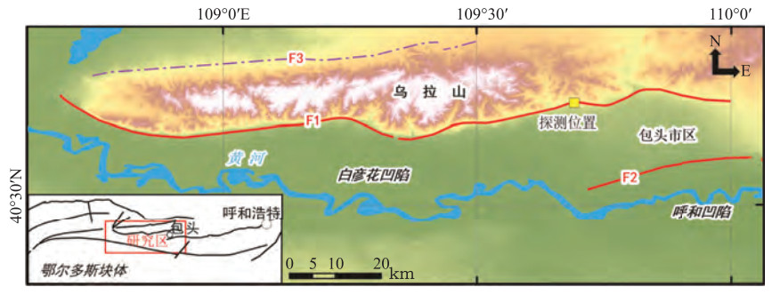
图 1 研究区断层分布图
F1:乌拉山山前断裂;F2:大青山山前断裂;F3:乌拉山北缘断裂
Figure 1. Fault distribution map of study area
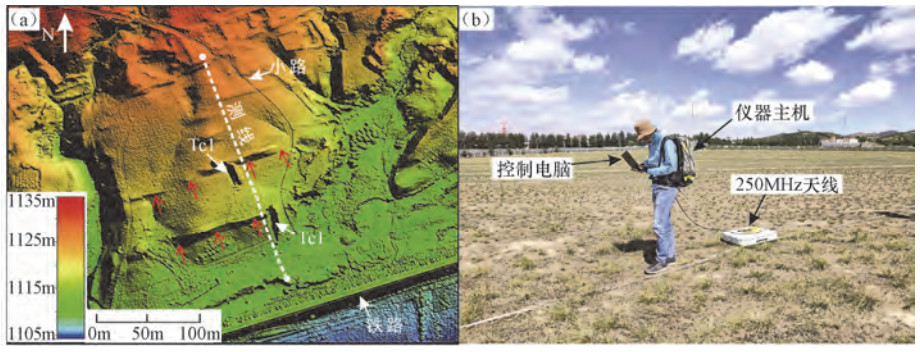
图 3 测线区域地形图和地质雷达数据采集系统图
Figure 3. Topographic map of survey line area and field data acquisition system of GPR
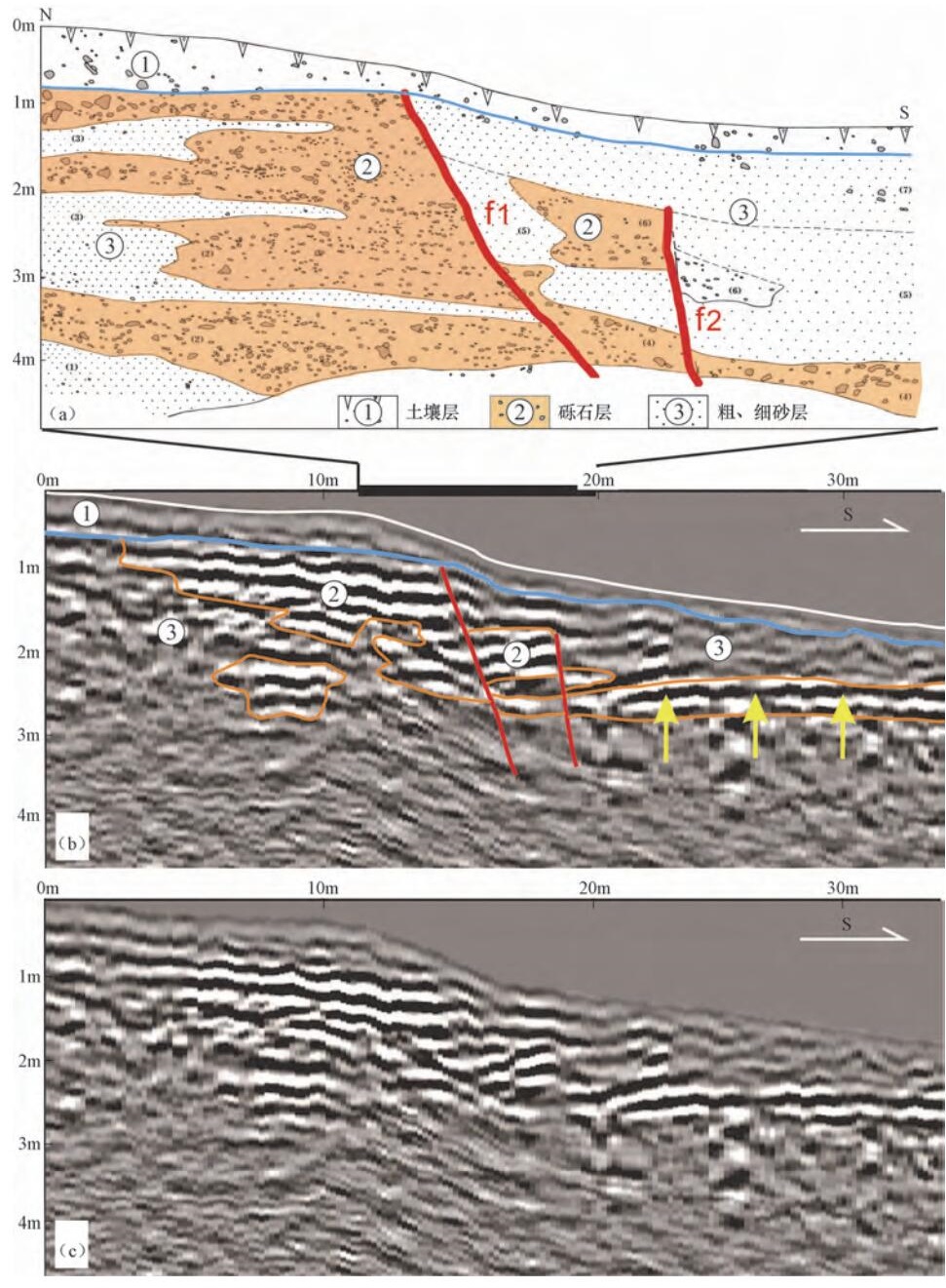
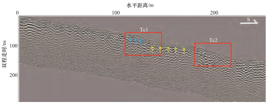
图 6 测线局部剖面与探槽Tc1剖面对照图
(a)Tc1剖面图;(b)局部雷达剖面解释图(黄色箭头对应为图 5强反射波组);(c)雷达剖面图
Figure 6. Comparison of local profile of survey line and the profile of trench Tc1

图 7 测线局部剖面与探槽Tc2剖面对比图
(a)Tc2剖面图;(b)局部雷达剖面解释图;(c)局部雷达剖面图
Figure 7. Comparison of local profile of survey line and the profile of trench Tc2
表 1 不同频率天线在土壤中的理论探测深度、分辨率表
Table 1. Theoretical detection depth of different frequency antennas in soil
天线中心频率/MHz 探测深度/m 垂向分辨率/m 50 15—20 0.50—1.00 100 8—12 0.25—0.50 250 3—7 0.10—0.25  下载: 导出CSV
-
陈立春, 2002.河套断陷带的古地震、强震复发规律和未来可能强震地点.北京:中国地震局地质研究所. 崔国柱, 李恩泽, 曾昭发, 2003.活动断层与地球物理方法.世界地质, 22(2):185-193. http://www.wanfangdata.com.cn/details/detail.do?_type=perio&id=sjdz200302016 邓起东, 陈立春, 冉勇康, 2004.活动构造定量研究与应用.地学前缘, 11(4):383-392. http://www.wanfangdata.com.cn/details/detail.do?_type=perio&id=dxqy200404005 邓起东, 程绍平, 闵伟等, 1999.鄂尔多斯块体新生代构造活动和动力学的讨论.地质力学学报, 5(3):13-21, 88. http://www.wanfangdata.com.cn/details/detail.do?_type=perio&id=dzlxxb199903003 何仲太, 2013.低频地质雷达在活断层探测的应用.地壳构造与地壳应力文集. 李大心, 1994.探地雷达方法与应用.北京:地质出版社. 李建军, 张军龙, 2015.探地雷达在探测隐伏活动断层中的应用.地震, 35(4):83-89. http://www.wanfangdata.com.cn/details/detail.do?_type=perio&id=diz201504009 李双飞, 李家存, 张迪, 2016.差分GPS实现探地雷达图像地形校正方法研究.地质力学学报, 22(3):771-777. http://www.wanfangdata.com.cn/details/detail.do?_type=perio&id=dzlxxb201603030 李彦宝, 冉勇康, 陈立春等, 2015.河套断陷带主要活动断裂最新地表破裂事件与历史大地震.地震地质, 37(1):110-125. http://www.wanfangdata.com.cn/details/detail.do?_type=perio&id=dzdz201501009 刘志成, 高战武, 徐伟等, 2019.河套断陷带包头凸起的构造特征.地震地质, 41(5):1105-1122. http://www.wanfangdata.com.cn/details/detail.do?_type=perio&id=dzdz201905003 马保起, 盛小青, 张守仁等, 1998.乌拉山山前断裂晚第四纪活动研究.地壳构造与地壳应力文集. 冉勇康, 邓起东, 1999.古地震学研究的历史、现状和发展趋势.科学通报, 44(1):12-20. http://www.wanfangdata.com.cn/details/detail.do?_type=perio&id=kxtb199901003 任丽丽, 李家存, 张迪等, 2014.激光点云实现探地雷达图像地形校正的研究.激光与红外, 44(8):870-873. http://www.wanfangdata.com.cn/details/detail.do?_type=perio&id=jgyhw201408008 薛建, 贾建秀, 黄航等, 2008.应用探地雷达探测活动断层.吉林大学学报(地球科学版), 38(2):347-350. http://www.wanfangdata.com.cn/details/detail.do?_type=perio&id=cckjdxxb200802028 俞祁浩, 屈建军, 郑本兴等, 2004.探地雷达在沙漠研究中的应用.中国沙漠, 24(3):371-375. http://www.wanfangdata.com.cn/details/detail.do?_type=perio&id=zgsm200403020 张迪, 李家存, 吴中海等, 2015.探地雷达在探测玉树走滑断裂带活动性中的初步应用.地质通报, 34(1):204-216. http://www.wanfangdata.com.cn/details/detail.do?_type=perio&id=zgqydz201501016 Audru J. C., Bano M., Begg J., et al., 2001. GPR investigations on active faults in urban areas:The Georisc-NZ project in Wellington, New Zealand.Comptes Rendus De Lacademie Des ences, 333 (8):447-454. http://www.sciencedirect.com/science/article/pii/S1251805001016639 Beauprêtre S., Garambois S., Manighetti I., et al., 2012. Finding the buried record of past earthquakes with GPR-based palaeoseismology:A case study on the Hope fault, New Zealand. Geophysical Journal International, 189:73-100. doi: 10.1111/j.1365-246X.2012.05366.x Beauprêtre S., Manighetti I., Garambois S., et al., 2013. Stratigraphic architecture and fault offsets of alluvial terraces at Te Marua, Wellington fault, New Zealand, revealed by pseudo-3D GPR investigation. Journal of Geophysical Research Solid Earth, 118(8):4564-4585. doi: 10.1002/jgrb.50317 Carpentier S. F. A., Green A. G., Doetsch J., et al., 2012. Recent deformation of Quaternary sediments as inferred from GPR images and shallow P-wave velocity tomograms:Northwest Canterbury Plains, New Zealand. Journal of Applied Geophysics, 81:2-15. doi: 10.1016/j.jappgeo.2011.09.007 Neal A., 2004. Ground-penetrating radar and its use in sedimentology:Principles, problems and progress. Earth-Science Reviews, 66 (3):261-330. http://www.sciencedirect.com/science/article/pii/S0012825204000054 Slater L., Niemi T. M., 2003. Ground-penetrating radar investigation of active faults along the Dead Sea Transform and implications for seismic hazards within the city of Aqaba, Jordan. Tectonophysics, 368(1):33-50. http://www.wanfangdata.com.cn/details/detail.do?_type=perio&id=39750056d57a7c8242f071ad575e9824 Zhao W. K., Forte E., Levi S. T., et al., 2015. Improved high-resolution GPR imaging and characterization of prehistoric archaeological features by means of attribute analysis. Journal of Archaeological Science, 54:77-85. doi: 10.1016/j.jas.2014.11.033 -


 点击查看大图
计量
- 文章访问数: 188
- HTML全文浏览量: 83
- PDF下载量: 21
- 被引次数: 0
