
Geomorphic Features and Tectonic Significance of the Middle and North Section of Longmenshan
-
摘要: 龙门山中北段位于青藏高原东缘,该区作为高原向东扩展的前缘部位,其地形与河流水系的演化记录了高原隆升与挤压扩展及其气候环境效应的各种信息。龙门山中北段构造活动有明显差异,从中段逆冲为主转化为北段的走滑为主,本文采用定量化地貌参数从构造地貌的角度揭示了区域构造活动的差异。龙门山中北段地貌因子(坡度、地形起伏度和条带状剖面)的阶梯状分布特点,显示了高原扩展的逆冲推覆特征,在中央断裂处构造抬升作用最强,同时显示出了南北向构造活动减弱的趋势,由中段的逆冲转换为北段逆冲兼走滑的形式。北川-映秀断裂两侧流域的HI值也显示了断裂上盘高、下盘低、沿走向减弱的趋势。综合分析认为,本区构造活动是地貌演化的主控因素,龙门山中北段地形存在差异,北川-映秀断裂两侧的小流域地貌指数分析显示,构造抬升活动自南向北减弱,中段以逆冲为主,北段为逆冲兼走滑。Abstract: The study of Quantitative geomorphological parameters is a common means of tectonic geomorphology for regional tectonic activities and their evolution. The middle and northern sections of the Longmenshan are located on the eastern margin of the Qinghai-Tibet plateau as the frontier part of the plateau expanding eastward. The evolution of the topography and river system in this area records abundant information about plateau uplift and extrusion expansion and its climatic environmental effects. The stepped distribution characteristics of the geomorphic factors (slope, topographic relief, swath profiles) in the middle and northern sections of the Longmenshan suggest the thrusting characteristics of the plateau expansion. The tectonic uplift is the strongest at the central fault and shows the tendency of the tectonic activity to weaken from north and south which is converted from the thrust of the middle section to the form of the thrust and strike slip of the northern section. The HI value of the basin on both sides of the Beichuan-Yingxiu fault also shows that the hanging wall of the fracture is relatively high. Based on the comprehensive analysis, the tectonic activities in this area are the main controlling factors of geomorphological evolution. There are differences in the topography of the middle and northern sections of Longmenshan. The geomorphological index analysis of the small watersheds on both sides of the Beichuan-Yingxiu fault shows that the tectonic uplifting activity is weakened from south to north, and the middle section is reversed. Mainly, the northern section is thrust with strike-slip component.
-
Key words:
- Slope /
- Relief /
- HI value /
- Tectonic activity
-
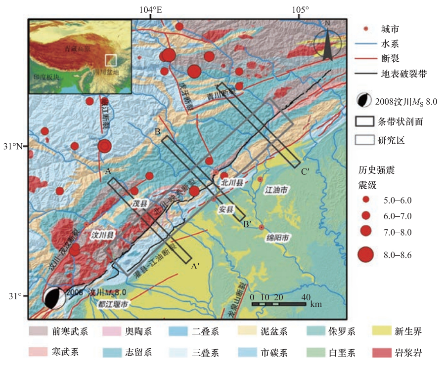
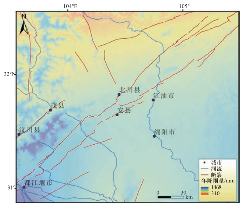
图 1 龙门山中北段区域构造及地质图
Figure 1. Simplified geological map of the central and northern sections of Longmenshan
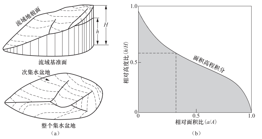
图 2 面积-高程积分曲线示意图(Singh等,2008)
Figure 2. Schematic diagram of area-elevation integral curve (fromh Singh et. al., 2008)
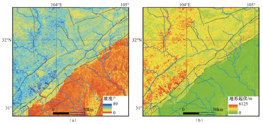
图 3 龙门山中北段坡度(a)与地形起伏度分布图(b)
Figure 3. Distribution of slope and topographic relief of the middle and north sections of Longmenshan
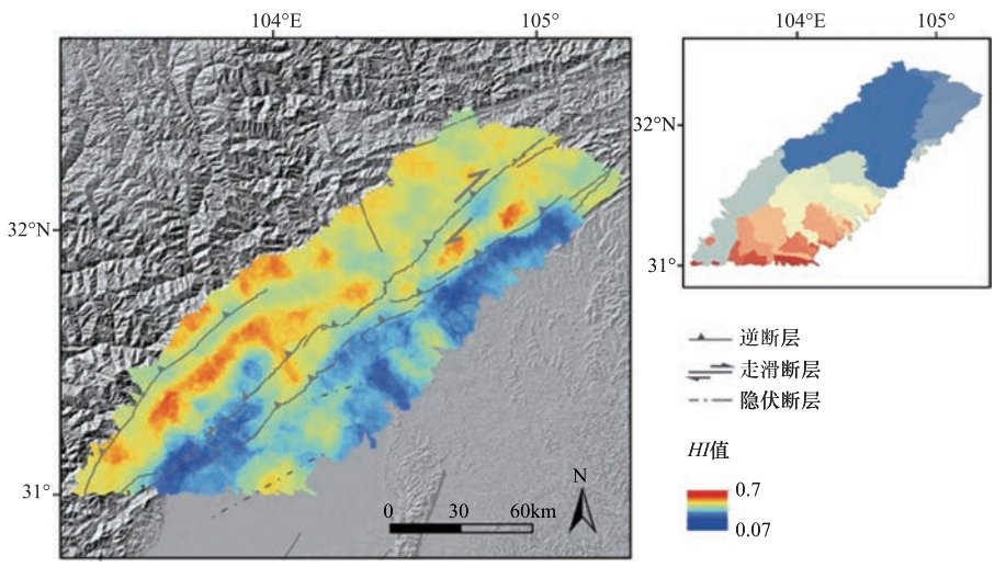
图 5 龙门山中北段流域分布图和HI值分布
Figure 5. The HI value distribution of the middle and north sections of Longmenshan
-
常直杨, 王建, 白世彪等. 2014.基于DEM的岷江上游流域构造活动强度分析.地球信息科学学报, 16(4):568-574. http://d.old.wanfangdata.com.cn/Periodical/dqxxkx201404009 常直杨, 孙伟红, 王建等. 2015.数字高程模型在构造地貌形态分析中的应用现状及展望.南京师大学报(自然科学版), 38(4):129-136. doi: 10.3969/j.issn.1001-4616.2015.04.023 陈社发, 邓起东, 赵小麟等. 1994.龙门山中段推覆构造带及相关构造的演化历史和变形机制(二).地震地质, 16(4):413-421. http://www.cnki.com.cn/Article/CJFDTotal-DZDZ404.015.htm 陈彦杰, 郑光佑, 宋国城. 2005.面积尺度与空间分布对流域面积高程积分及其地质意义的影响(英文).地理学报, 39:53-59. 樊春, 王二七, 王刚等. 2008.龙门山断裂带北段晚新近纪以来的右行走滑运动及其构造变换研究——以青川断裂为例.地质科学, 43(3):417-433. doi: 10.3321/j.issn:0563-5020.2008.03.001 何祥丽, 张绪教, 何泽新. 2014.基于构造地貌参数的新构造运动研究进展与思考.现代地质, 28(1):119-130. doi: 10.3969/j.issn.1000-8527.2014.01.011 贾营营, 付碧宏, 王岩等. 2010.青藏高原东缘龙门山断裂带晚新生代构造地貌生长及水系响应.第四纪研究, 30(4):825-836. doi: 10.3969/j.issn.1001-7410.2010.04.17 姜大伟, 张世民, 李伟等. 2018.龙门山南段前陆区晚第四纪构造变形样式.地球物理学报, 61(5):1949-1969. http://d.old.wanfangdata.com.cn/Periodical/dqwlxb201805024 李传友, 宋方敏, 冉勇康. 2004.龙门山断裂带北段晚第四纪活动性讨论.地震地质, 26(2):248-258. doi: 10.3969/j.issn.0253-4967.2004.02.007 李奋生, 赵国华, 李勇等. 2015.龙门山地区水系发育特征及其对青藏高原东缘隆升的指示.地质论评, 61(2):345-355. http://d.old.wanfangdata.com.cn/Periodical/dzlp201502009 李勇, 周荣军, Densmore A.L.等. 2006.青藏高原东缘龙门山晚新生代走滑-逆冲作用的地貌标志.第四纪研究, 26(1):40-51. doi: 10.3321/j.issn:1001-7410.2006.01.006 梁明剑, 郭红梅, 李大虎等. 2013.2013年四川芦山7.0级地震发震构造机理及青衣江上游流域地貌的响应.地学前缘, 20(6):21-28. http://d.old.wanfangdata.com.cn/Periodical/dqwlxb201306011 梁明剑, 周荣军, 闫亮等. 2014.青海达日断裂中段构造活动与地貌发育的响应关系探讨.地震地质, 36(1):28-38. doi: 10.3969/j.issn.0253-4967.2014.01.003 梁欧博, 任俊杰, 吕延武. 2018.涪江流域河流地貌特征对虎牙断裂带活动性的响应.地震地质, 40(1):42-56. doi: 10.3969/j.issn.0253-4967.2018.01.004 林茂炳, 吴山. 1991.龙门山推覆构造变形特征.成都地质学院学报, 18(1):46-55. http://d.old.wanfangdata.com.cn/Periodical/cdlgxyxb200103003 刘静, 张智慧, 文力等. 2008.汶川8级大地震同震破裂的特殊性及构造意义——多条平行断裂同时活动的反序型逆冲地震事件.地质学报, 82(12):1707-1722. doi: 10.3321/j.issn:0001-5717.2008.12.007 马保起, 苏刚, 侯治华等. 2005.利用岷江阶地的变形估算龙门山断裂带中段晚第四纪滑动速率.地震地质, 27(2):234-242. doi: 10.3969/j.issn.0253-4967.2005.02.006 南希, 李爱农, 景金城. 2017.中国山地起伏度计算中地形自适应滑动窗口获取与验证.地理与地理信息科学, 33(4):34-39. doi: 10.3969/j.issn.1672-0504.2017.04.006 邵崇建, 李勇, 赵国华等. 2015.基于面积-高程积分对龙门山南段山前河流的构造地貌研究.现代地质, 29(4):727-737. doi: 10.3969/j.issn.1000-8527.2015.04.002 苏琦, 袁道阳, 谢虹. 2016.祁连山-河西走廊黑河流域地貌特征及其构造意义.地震地质, 38(3):560-581. doi: 10.3969/j.issn.0253-4967.2016.03.005 苏琦, 袁道阳, 谢虹. 2017.祁连山东段石羊河流域及邻区地貌特征及其构造意义.地质论评, 63(1):7-20. http://d.old.wanfangdata.com.cn/Periodical/dzlp201701002 徐锡伟, 闻学泽, 叶建青等. 2008.汶川MS 8.0地震地表破裂带及其发震构造.地震地质, 30(3):597-629. http://d.old.wanfangdata.com.cn/Periodical/dzdz200803003 杨晓平, 蒋溥, 宋方敏等. 1999.龙门山断裂带南段错断晚更新世以来地层的证据.地震地质, 21(4):341-345. doi: 10.3969/j.issn.0253-4967.1999.04.007 姚琪, 邢会林, 徐锡伟等. 2012.断裂两盘岩性差异对汶川地震的影响.地球物理学报, 55(11):3634-3647. doi: 10.6038/j.issn.0001-5733.2012.11.012 张会平, 杨农, 刘少峰等. 2006a.数字高程模型(DEM)在构造地貌研究中的应用新进展.地质通报, 25(6):660-669. http://d.old.wanfangdata.com.cn/Periodical/zgqydz200606002 张会平, 杨农, 张岳桥等. 2006b.岷江水系流域地貌特征及其构造指示意义.第四纪研究, 26(1):126-135. http://d.old.wanfangdata.com.cn/Periodical/dsjyj200601016 赵洪壮, 李有利, 杨景春. 2010.北天山流域河长坡降指标与Hack剖面的新构造意义.北京大学学报(自然科学版), 46(2):237-244. http://www.wanfangdata.com.cn/details/detail.do?_type=perio&id=bjdxxb201002012 郑光佑. 2002.台湾西部麓山带前缘流域面积高度积分之构造意义研究.台南:国立高雄师范大学. 周荣军, 李勇, Densmore A.L.等. 2006.青藏高原东缘活动构造.矿物岩石, 26(2):40-51. doi: 10.3969/j.issn.1001-6872.2006.02.007 Alipoor R., Poorkermani M., Zare M., et al.. 2011. Active tectonic assessment around Rudbar Lorestan dam site, High Zagros Belt (SW of Iran). Geomorphology, 128(1-2):1-14. doi: 10.1016/j.geomorph.2010.10.014 Burchiel B. C., Royden L. H., van der Hilst R. D., et al.. 2008. A geological and geophysical context for the Wenchuan earthquake of 12 May 2008, Sichuan. People's Republic of China, GSA Today, 18(7):4-11. doi: 10.1080-00952990903060119/ Densmore A. L., Ellis M. A., Li Y., et al.. 2007. Active tectonics of the Beichuan and Pengguan faults at the eastern margin of the Tibetan Plateau. Tectonics, 26(4):TC4005. doi: 10.1029-2006TC001987/ England P., Molnar P.. 1990. Surface uplift, uplift of rocks, and exhumation of rocks. Geology, 18(12):1173-1177. doi: 10.1130/0091-7613(1990)018<1173:SUUORA>2.3.CO;2 Gao M. X., Zeilinger G., Xu X. W., et al.. 2013. DEM and GIS analysis of geomorphic indices for evaluating recent uplift of the northeastern margin of the Tibetan Plateau, China. Geomorphology, 190:61-72. doi: 10.1016/j.geomorph.2013.02.008 Hack J. T.. 1973. Stream-profile analysis and stream-gradient index. Journal of Research of the U.S. Geological Survey, 1(4):421-429. http://cn.bing.com/academic/profile?id=ebc62280da7aebf0286d5ab2e8e1845c&encoded=0&v=paper_preview&mkt=zh-cn Hartshorn K., Hovius N., Dade W. B., et al.. 2002. Climate-Driven bedrock incision in an active mountain belt. Science, 297(5589):2036-2038. doi: 10.1126/science.1075078 Hijmans R. J., Cameron S. E., Parra J. L., et al.. 2005. Very high resolution interpolated climate surfaces for global land areas. International Journal of Climatology, 25(15):1965-1978. doi: 10.1002/joc.1276 Kirby E., Whipple K. X., Tang W. Q., et al.. 2003. Distribution of active rock uplift along the eastern margin of the Tibetan Plateau:inferences from bedrock channel longitudinal profiles. Journal of Geophysical Research:Solid Earth, 108(B4):2217. doi: 10.1029-2001JB000861/ Kirby E., Whipple K., Harkins N.. 2008. Topography reveals seismic hazard. Nature Geoscience, 1(8):485-487. doi: 10.1038/ngeo265 Kirby E., Whipple K. X.. 2012. Expression of active tectonics in erosional landscapes. Journal of Structural Geology, 44:54-75. doi: 10.1016/j.jsg.2012.07.009 Pike R. J., Wilson S. E.. 1971. Elevation-relief ratio, hypsometric integral, and geomorphic area-altitude analysis. GSA Bulletin, 82(4):1079-1084. doi: 10.1130/0016-7606(1971)82[1079:ERHIAG]2.0.CO;2 Scherler D., Bookhagen B., Strecker M. R.. 2014. Tectonic control on 10Be-derived erosion rates in the Garhwal Himalaya, India. Journal of Geophysical Research:Earth Surface, 119(2):83-105. doi: 10.1002/2013JF002955 Schmidt K. M., Montgomery D. R.. 1995. Limits to relief. Science, 270(5236):617-620. doi: 10.1126/science.270.5236.617 Singh O., Sarangi A., Sharma M. C.. 2008. Hypsometric integral estimation methods and its relevance on erosion status of North-Western Lesser Himalayan Watersheds. Water Resources Management, 22(11):1545-1560. doi: 10.1007/s11269-008-9242-z Strahler A. N.. 1952. Hypsometric (area-altitude) analysis of erosional topography. GSA Bulletin, 63(11):1117-1142. doi: 10.1130/0016-7606(1952)63[1117:HAAOET]2.0.CO;2 Tan X. B., Liu Y. D., Lee Y. H., et al.. 2019. Parallelism between the maximum exhumation belt and the Moho ramp along the eastern Tibetan Plateau margin: coincidence or consequence? Earth and Planetary Science Letters, 507: 73-84. Tian Y. T., Kohn B. P., Gleadow A. J. W., et al.. 2013. Constructing the Longmen Shan eastern Tibetan Plateau margin:insights from low-temperature thermochronology. Tectonics, 32(3):576-592. doi: 10.1002/tect.20043 Willett, S. D., Brandon M. T.. 2002. On steady states in mountain belts. Geology, 30(2):175-178. doi: 10.1130-0091-7613(2002)030-0175-OSSIMB-2.0.CO%3b2/ Zhang H. P., Liu S. F., Yang N., et al.. 2006. Geomorphic characteristics of the Minjiang drainage basin (eastern Tibetan Plateau) and its tectonic implications:new insights from a digital elevation model study. Island Arc, 15(2):239-250. doi: 10.1111/j.1440-1738.2006.00524.x Zhang H. P., Zhang P. Z., Kirby E., et al.. 2011. Along-strike topographic variation of the Longmen Shan and its significance for landscape evolution along the eastern Tibetan Plateau. Journal of Asian Earth Sciences, 40(4):855-864. doi: 10.1016/j.jseaes.2010.05.015 -

 下载:
下载:
 点击查看大图
计量
- 文章访问数: 201
- HTML全文浏览量: 96
- PDF下载量: 14
- 被引次数: 0
