Slip Rate of Lijiang-Xiaojinhe Fault in the Holocene
-
摘要: 丽江-小金河断裂与锦屏山断裂共同控制着青藏高原东南边界,研究该断裂的滑动速率有助于理解青藏高原东南缘区域变形模式。本文通过高分辨率遥感影像解译与野外地质调查,发现该断裂错断了一系列河流阶地与洪积扇,且以左旋走滑为主兼具倾滑分量。通过无人机断错地貌测量与碳同位素断代,获得红星-尖山营断裂段全新世左旋走滑速率为(3.32±0.22)mm/a,垂直滑动速率为(0.35±0.02)mm/a;汝南-南溪断裂段北支全新世左旋走滑速率为(2.37±0.20)mm/a。Abstract: The Lijiang-Xiaojinhe fault jointed with the Jinpingshan fault control the southeastern boundary of the Qinghai-Tibet Plateau. The study on the activity of the Lijiang-Xiaojinhe fault is of great significance for understanding the deformation mode of the southeastern margin of the Qinghai-Tibet Plateau. Interpretation of high-resolution remote sensing images and field geological surveys revealed that the faults have offset a series of river terraces and alluvial fans,with a left-lateral strike-slip and a small amount of tilt-slip. Through the fault geomorphology measurement by UAV and the age determination by carbon isotope dating,we estimated that the left-lateral strike-slip rate of in the Hongxing-Jianshanying fault segment since the Holocene is about 3.32±0.22 mm/a,and the vertical slip rate is about 0.35±0.02 mm/a,and the left-lateral strike-slip rate of the northern branch of the Runan-Nanxi fault segment since the Holocene is about 2.37±0.15 mm/a.
-
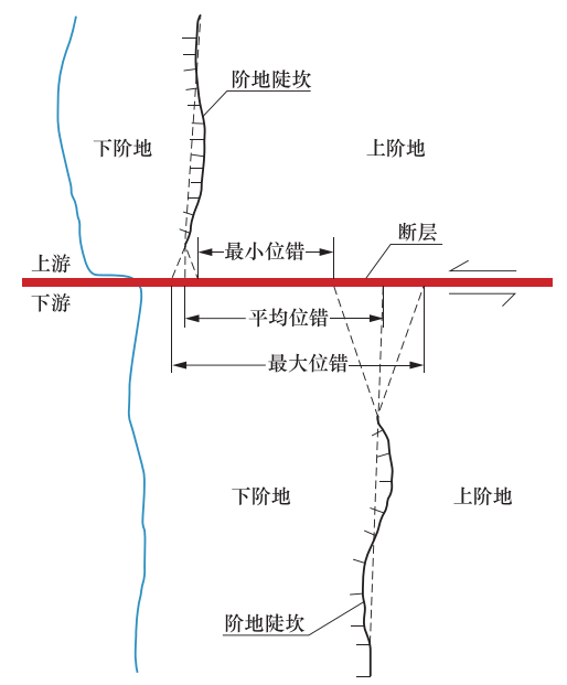
图 4 断错位移量测量误差示意(Gold等, 2011)
Figure 4. Schematic diagram of measurement error of fault
表 1 无人机现场作业参数
Table 1. UAV field operation parameters
编号 位置 飞行高度/m 照片数 图像面积/km2 点云密度/m3 图像分辨率/cm 航向重叠率/% 旁向重叠率/% 1 旦读 90 214 1.05 8.91 6.61 80 65 2 尖山营 70 50 0.21 20.3 5.13 80 65 -
程佳,徐锡伟,甘卫军等. 2012.青藏高原东南缘地震活动与地壳运动所反映的块体特征及其动力来源.地球物理学报,55(4):1198-1212. http://d.old.wanfangdata.com.cn/Periodical/dqwlxb201204016 丁锐,任俊杰,张世民等. 2018.丽江-小金河断裂中段晚第四纪古地震历史.地震地质,40(3):622-640. http://d.old.wanfangdata.com.cn/Periodical/dzdz201803009 罗浩,何文贵,王定伟等. 2013.祁连山昌马断裂晚更新世滑动速率.地震地质,35(4):765-777. http://d.old.wanfangdata.com.cn/Periodical/dzdz201304007 向宏发,徐锡伟,虢顺民等. 2002.丽江-小金河断裂第四纪以来的左旋逆推运动及其构造地质意义——陆内活动地块横向构造的屏蔽作用.地震地质,24(2):188-198. http://www.wanfangdata.com.cn/details/detail.do?_type=perio&id=dzdz200202006 徐锡伟,闻学泽,郑荣章等. 2003.川滇地区活动块体最新构造变动样式及其动力来源.中国科学(D辑),33(S1):151-162. http://www.wanfangdata.com.cn/details/detail.do?_type=perio&id=zgkx-cd2003z1017 许志琴,李化启,侯立炜等. 2007.青藏高原东缘龙门-锦屏造山带的崛起——大型拆离断层和挤出机制.地质通报,26(10):1262-1276. http://www.wanfangdata.com.cn/details/detail.do?_type=perio&id=zgqydz200710005 张培震,李传友,毛凤英. 2008.河流阶地演化与走滑断裂滑动速率.地震地质,30(1):44-57. http://d.old.wanfangdata.com.cn/Periodical/dzdz200801004 Bai M. K., Chevalier M. L., Pan J. W., et al.. 2018. Southeastward increase of the late Quaternary slip-rate of the Xianshuihe fault, eastern Tibet. Geodynamic and seismic hazard implications. Earth and Planetary Science Letters, 485:19-31. http://www.wanfangdata.com.cn/details/detail.do?_type=perio&id=52c4e98960ea37262ccfe7f0c5b74cbc Behr, W. M., Rood, D. H., Fletcher, K. E., et al.. 2010. Uncertainties in slip-rate estimates for the Mission Creek strand of the southern San Andreas fault at Biskra Palms Oasis, southern California. GSA Bulletin, 122(9-10):1360-1377. doi: 10.1130/B30020.1 Burbank D. W., Anderson R. S.. 2012. Tectonic geomorphology. 2nd ed. Chichester:Wiley. Burchfiel B. C., Chen Z. L., Liu Y., et al.. 1995. Tectonics of the Longmen Shan and adjacent regions, central China. International Geology Review, 37(8):661-735. doi: 10.1080/00206819509465424 Burchfiel B. C., Chen Z.. 2013. Tectonics of the southeastern Tibetan Plateau and its adjacent foreland. Boulder:Geological Society of America. Cowgill E.. 2007. Impact of riser reconstructions on estimation of secular variation in rates of strike-slip faulting:Revisiting the Cherchen River site along the Altyn Tagh Fault, NW China. Earth and Planetary Science Letters, 254(3-4):239-255. doi: 10.1016/j.epsl.2006.09.015 Gold R. D., Cowgill E., Arrowsmith J. R., et al.. 2011. Faulted terrace risers place new constraints on the late Quaternary slip rate for the central Altyn Tagh fault, northwest Tibet. GSA Bulletin, 123(5-6):958-978. doi: 10.1130/B30207.1 Hetzel R., Hampel A., Gebbeken P., et al.. 2019. A constant slip rate for the western Qilian Shan frontal thrust during the last 200 ka consistent with GPS-derived and geological shortening rates. Earth and Planetary Science Letters, 509:100-113. doi: 10.1016/j.epsl.2018.12.032 Shen Z K, Lü J, Wang M, et al.. 2005. Contemporary crustal deformation around the southeast borderland of the Tibetan Plateau. J Geophys Res, 110:B11409. doi: 10.1029-2004JB003421/ Wells D. L., Coppersmith K. J.. 1994. New empirical relationships among magnitude, rupture length, rupture width, rupture area, and surface displacement. Bulletin of the Seismological Society of America, 84(4):974-1002. http://cn.bing.com/academic/profile?id=150c7e5c280a023d24460e3ba759c397&encoded=0&v=paper_preview&mkt=zh-cn Zhang P. Z., Molnar P., Xu X. W.. 2007. Late Quaternary and present-day rates of slip along the Altyn Tagh Fault, northern margin of the Tibetan Plateau. Tectonics, 26(5):TC5010. http://www.wanfangdata.com.cn/details/detail.do?_type=perio&id=d97ba2abed03cee284c3d9206a85a690 -


 下载:
下载:
