Comparative Analysis of Life Loss Assessment Caused by 2017 MS 5.5 Taxkorgan Earthquake in Xinjiang, China
-
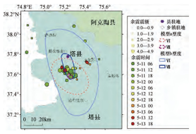
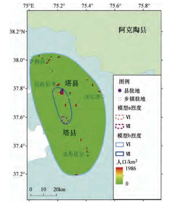
摘要: 2017年5月11日,新疆喀什地区塔什库尔干县发生5.5级地震。地震造成8人死亡、31人受伤以及财产损失,属于典型的“小震大灾”。按照一般的地震灾害损失快速评估方法,得到的评估结果与实际结果差别较大。为探讨评估结果偏离的原因,本文对不同地震损失评估方案进行比较分析,探讨了地震致灾性(地震影响场分布)、承灾体(人口)分布等因素对地震损失评估结果的影响。结果表明在此次地震快速评估中,基于宏观震中确定的地震影响场较微观震中更接近实际分布;地震烈度衰减的平均估计模型给出的地震烈度区面积明显小于实际面积;极震区存在抗震能力相对低的土木、砖木结构房屋,是造成该地震震级相对小而生命损失相对大的“小震大灾”的重要原因。对比分析结果表明,提高人口、房屋建筑等风险暴露数据的空间精准性,改善地震震中定位与地震影响场估计的准确性,将有助于提高地震应急损失评估的准确性。Abstract: An MS 5.5 earthquake struck Taxkorgan county, Xinjiang, China on May 11, 2017. The earthquake caused 8 death, 31injured, and all kinds of property losses, is the typical event so-called "disasters by small earthquake". The rapid assessed earthquake losses according to the general method, are quite different from the actual ones. Therefore, it is of great significance to carry out the comparative analysis of the assessments of the earthquake losses and to understand the reasons of the deviation of the evaluation results in order to improve the assessment method. This paper analyzes the effect of earthquake disaster (seismic intensity distribution) and the population distribution etc. on the evaluation of earthquake life loss. The results show that seismic intensity distribution estimated according to elliptical seismic intensity attenuation model centered with macro-epicenter is of better estimation to the practical seismic intensity distribution than that with micro-epicenter. Another reason is that the area of seismic intensity region is significantly smaller than that of the practical one. We believe that because of the relatively high population density and relatively low anti-seismic capability of adobe and brick-wood structure buildings in the extreme disaster area, the unexpected high life loss was caused by such a earthquake of small magnitude. The comparative analysis results demonstrate that it will be helpful to improve the accuracy of emergency earthquake loss assessment through improvement of the high quality data of population, building and other risk related, as well as the accuracy of fast estimated earthquake location and seismic intensity distribution.
-
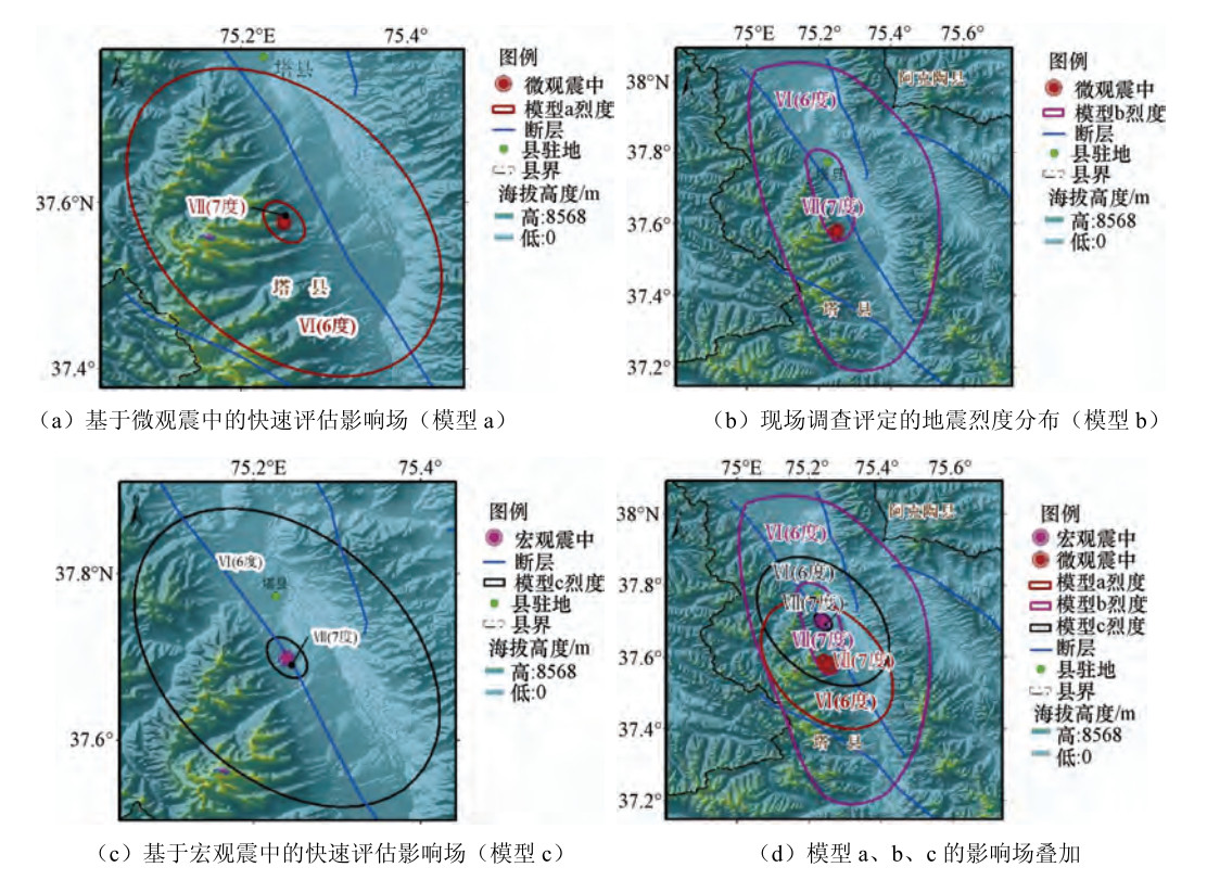
表 1 地震影响场评估模型
Table 1. Assessment models of seismic intensity distribution
模型编号 模型名称 模型来源 震中位置 a 新疆烈度衰减模型 俞言祥等(2013) 微观震中 b 现场调查烈度图 新疆地震局(2017) c 新疆烈度衰减模型 俞言祥等(2013) 现场评定烈度图极震区中心点 表 2 不同影响场评估方案的地震损失评估结果对比
Table 2. Comparison of casualty between estimated number to the real number
评估模型 最高烈度 Ⅶ度区面积/km2 Ⅵ度区面积/km2 评估死亡人数 a Ⅶ 17 930 0 b Ⅶ 227 3061 6 c Ⅶ 17 930 2 -
丁玲, 王晓青, 王书民等, 2017.面向地震风险评估的中国大陆区县级人口总量时空预测方法研究.地震, 37(4):58-68. doi: 10.3969/j.issn.1000-3274.2017.04.006 窦爱霞, 丁玲, 2019.建筑物时空分布研究.见: 《2016-2025年中国大陆地震危险区与地震灾害损失预测研究》项目组主编, 《2016-2025年中国大陆地震危险区与地震灾害损失预测研究》.北京: 中国地图出版社. 傅征祥, 李革平, 1993.地震生命损失研究.北京:地震出版社, 194. 国家地震局, 国家统计局, 1996.中国大陆地震灾害损失评估汇编(1990-1995).北京:地震出版社, 210. 王晓青, 丁香, 2019.2016-2025年中国大陆地震损失预测研究.见: 《2016-2025年中国大陆地震危险区与地震灾害损失预测研究》项目组主编, 《2016-2025年中国大陆地震危险区与地震灾害损失预测研究》.北京: 中国地图出版社. 新疆地震局, 2017.新疆塔什库尔干5.5级地震烈度图.乌鲁木齐: 新疆地震局.http://www.cea.gov.cn/publish/dizhenj/468/553/102562/102564/20170513144218567209462/index.html 俞言祥, 李山有, 肖亮, 2013.为新区划图编制所建立的地震动衰减关系.震灾防御技术, 8(1):24-33. doi: 10.3969/j.issn.1673-5722.2013.01.003 袁小祥, 丁玲, 2019.人口经济时空预测研究.见: 《2016-2025年中国大陆地震危险区与地震灾害损失预测研究》项目组主编, 《2016-2025年中国大陆地震危险区与地震灾害损失预测研究》.北京: 中国地图出版社. 张桂欣, 孙柏涛, 陈相兆, 2017.分区分类的生命线工程地震直接经济损失研究.地震, 37(4):69-79. doi: 10.3969/j.issn.1000-3274.2017.04.007 中国地震局监测预报司, 2001.中国大陆地震灾害损失评估汇编(1996-2000).北京:地震出版社, 390. 中国地震局震灾应急救援司, 2010.2001-2005年中国大陆地震灾害损失评估汇编.北京:地震出版社, 210. -


 下载:
下载:


