
Investigation and Implication of the Seismic Disasters Caused by the 2016 Kaikoura MW 7.8 Earthquake, New Zealand
-
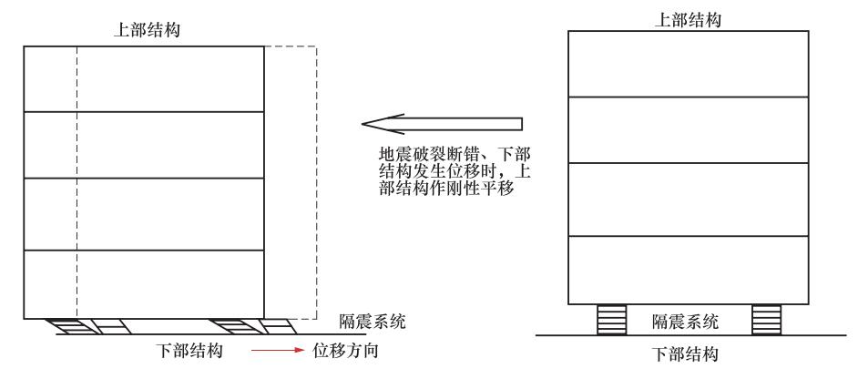
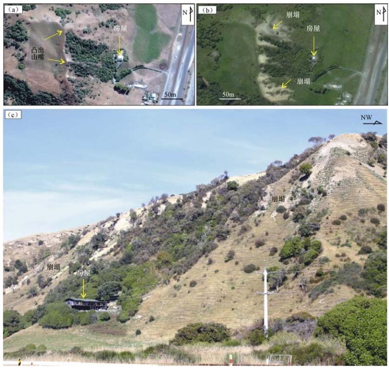
摘要: 在2016年新西兰凯库拉MW 7.8地震中,北东—北东东向科科仁古断裂水平右旋位移量最大,为10—12m;北北西—近南北向帕帕提断裂垂直位移量最大,达到5—6m。对直接坐落在这2条地震地表破裂带或变形带之上的建筑物的破坏现场调查表明,尽管房屋出现歪斜,但上部主体部分基本完整,没有出现倒塌或部分倒塌现象,避免了人员伤亡。在无法回避活动断裂及其大震危险性的情况下,隔震系统的广泛采用可以有效地提高建筑物抵御地震灾害的能力。此次地震触发了数万个滑坡体,最大滑坡体可达数百万立方米。对沃罗村北边2处边坡失稳地带的考察结果表明,针对该地至少从2个方面进行了考虑和处置:一是在选址上,避开了突出山嘴等高陡坡地带;二是在房屋正对的山坡地带,种植或保护了茂密的树木,这既增加了山体的稳定性,又可以在地震中有效地减缓崩塌的石块对房屋的冲击。对比中国中东部一些大震,如1976年唐山7.8级地震和2008年汶川8.0级地震中触目惊心的巨大人员伤亡和财产损失,即使在人口密度与滑坡规模上存在明显不同,对新西兰凯库拉地震灾害现场的考察结果,还是在如何有效抵御地震灾害方面给我们提供了很好的启示。Abstract: The 2016 Kaikoura MW 7.8 earthquake in New Zealand occurred at the Kekerengu fault with the strike of N-NNE and generated the horizontal displacement of 10-12m. Whereas the largest vertical displacement up to 5-6m was observed on the Papatea fault trending NNW-SN. In the field two houses are directly on these two faults. Although the houses are skewed by the ruptures along faults, the structures of the houses is basically intact, and no collapse or partial collapse was found. Such achievement of the goal of "Not collapse during the strong earthquake" successfully avoid the casualties. Generally, since the active faults and large earthquakes cannot be avoided in practice, the widespread adoption of earthquake isolation systems can effectively improve the ability of buildings to withstand earthquake disasters. The 2016 Kaikoura MW 7.8 earthquake triggered a large number of landslides, and many landslides are with huge volumes. Although the earthquake-triggered landslides caused serious damage to traffic, there were no reports of casualties or house damage caused by landslides. Investigation of two houses on the slope region at the north of the Oaro village showed that it is not a coincidence for the "good luck" of houses and their residents during the earthquake, but is closely related to the purposive prevention in advance. In the construction of the two "lucky" houses, some aspects have been considered to increase the anti-earthquake capability. For example, the site has been selected carefully to avoid the high steep slope, and trees have been planted on the slopes to increase the stability of slope and to reduce the impact of avalanches and fall stones on the houses effectively during the earthquake. In contrast, the landslides induced by the 2008 Wenchuan earthquake have caused heavy casualties and property losses in Sichan province of China. Considering the strong earthquakes in the east of China, such as the 1976 MS 7.8 Tangshan earthquake and the 2008 MS 8.0 Wenchuan earthquake, there is a complex corresponding relationship between the surface ruptures induced by these earthquakes and the distribution pattern of known active faults. Finally, the population density and landslide size in China is greater than that in New Zealand, some important implications from the investigation results of the 2016 Kaikoura MW 7.8 earthquake are very valuable for the earthquake prevention and disaster reduction planning in China.
-
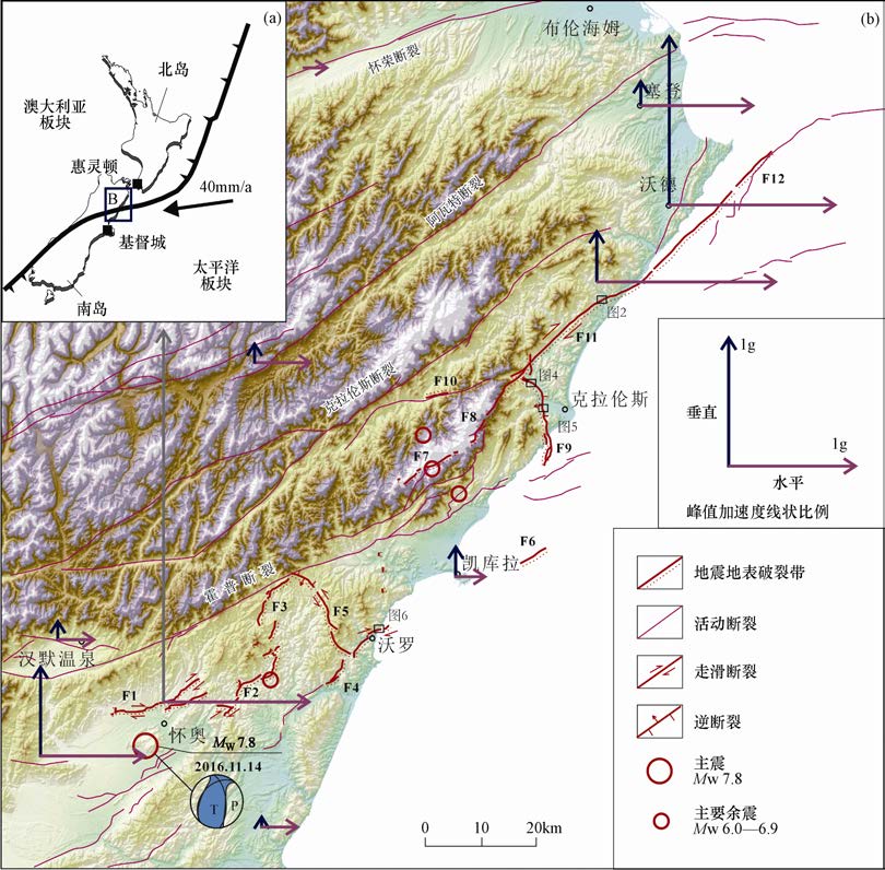
图 1 新西兰凯库拉MW 7.8地震地表破裂带与峰值加速度分布图1
F1:贺姆普斯(The Humps)断裂;F2:南里德尔(South Leader)断裂;F3:北里德尔(North Leader)断裂;F4:珲达里(Hundalee)断裂;F5:查威(Charwell)断裂;F6:鄱恩特肯(Point Kean)断裂;F7:上蔻海(Upper Kowhai)断裂;F8:约顿(Jordan)断裂;F9:帕帕提(Papatea)断裂;F10:菲德葛特(Fidget)断裂;F11:科科仁古(Kekerengu)断裂;F12:尼德斯(Needles)断裂
Figure 1. Distribution of the fault surface ruptures and peak acceleration of the Kaikoura MW 7.8 earthquake, New Zealand
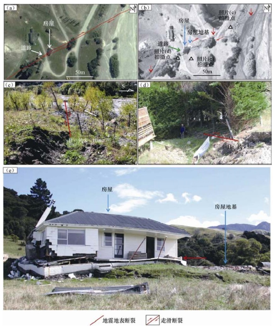
图 2 科科仁古断裂上地震地表破裂带与建筑物破坏状况
(a)地震地表破裂分布图,底图为震前遥感影像,据Google Earth 2016年2月14日图像;(b)震后遥感影像,据Google Earth 2016年11月15日图像,红色箭头指示地震地表破裂分布位置;(c)、(d)、(e)为现场调查照片,拍摄地点参见图(b)
Figure 2. The building damage along earthquake fault surface rupture at the Kekerengu fault
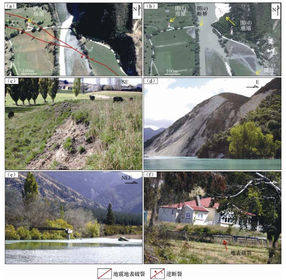
图 4 帕帕提断裂北段地震地质灾害与房屋破坏状况
(a)地震地表破裂带分布图,底图为震前遥感影像,据Google Earth 2016年3月26日图像;(b)震后遥感影像,据Google Earth 2016年11月15日图像;(c)、(d)、(e)、(f)为现场调查照片,拍摄地点参见图(b)
Figure 4. The earthquake geological disasters and the building damage at the north section of the Papatea fault
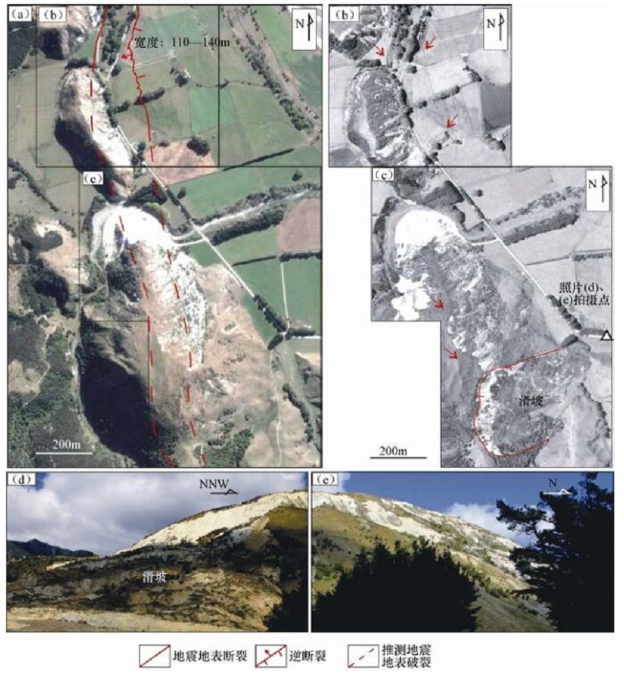
图 5 帕帕提断裂中段地震地表破裂带与地震滑坡
(a)地震地表破裂带分布图,底图为震前遥感影像,据Google Earth2016年3月26日图像;(b)、(c)为震后遥感影像,据Google Earth2016年11月15日图像;(d)、(e)为现场调查照片,拍摄地点参见图(c)
Figure 5. The earthquake fault surface rupture and earthquake landslides at the central section of the Papatea fault
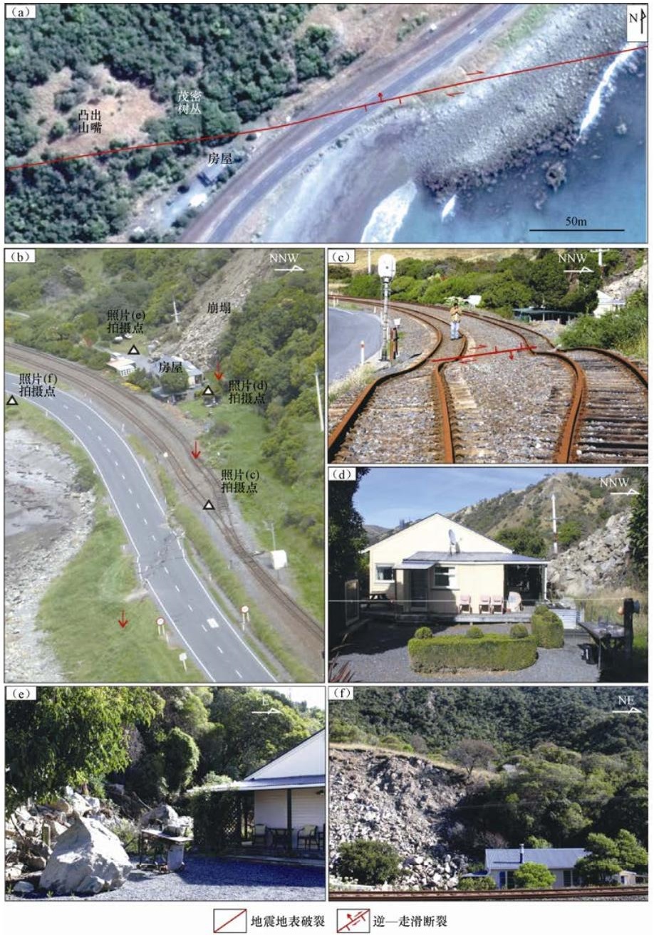
图 6 珲达里断裂与1号公路交汇处地震地表破裂带、崩塌与房屋破坏状况
(a)地震地表破裂带分布图,底图为震前遥感影像,据Google Earth2015年2月18日图像;(b)震后航空照片,据GNS;(c)、(d)、(e)、(f)为现场调查照片,拍摄地点参见图(b)
Figure 6. The earthquake fault surface ruptures, land-collapse and building damage at the intersection of Hundalee fault and Highway No.1
-
邓起东, 王挺梅, 李建国等, 1976.关于海城地震震源模式的讨论.地质科学, 11(3):195-204. http://www.cnki.com.cn/Article/CJFDTOTAL-ZGZD502.004.htm 邓起东, 2008.关于四川汶川8.0级地震的思考.地震地质, 30(4):811-827. http://mall.cnki.net/magazine/article/DZDZ200804003.htm 傅育安, 1988.新西兰的桥梁隔震技术.世界地震工程, 4(4):22-27, 21. https://www.wenkuxiazai.com/doc/f782981a10a6f524ccbf856e-2.html 国家地震局震害防御司, 1995.中国历史强震目录.北京:地震出版社, 514. 虢顺民, 李志义, 程绍平等, 1977.唐山地震区域构造背景和发震模式的讨论.地质科学, 12(4):305-321. http://www.cnki.com.cn/Article/CJFDTOTAL-DZDZ198403004.htm 韩竹军, Litchfield N., 冉洪流等, 2017.新西兰2016年凯库拉MW 7.8地震地表破裂带特征初析.地震地质, 39(4):675-688. http://kns.cnki.net/KCMS/detail/detail.aspx?filename=dzdz201704004&dbname=CJFD&dbcode=CJFQ 徐锡伟, 闻学泽, 叶建青, 2008.汶川MS 8.0地震地表破裂带及其发震构造.地震地质, 30(3):597-629. doi: 10.1007/s11430-015-5170-y-44?slug=full%20text 徐锡伟, 郭婷婷, 刘少卓等, 2016.活动断层避让相关问题的讨论.地震地质, 38(3):477-502. http://www.cnki.com.cn/Article/CJFDTotal-DZDZ201603001.htm 杨晓平, 李安, 刘保金等, 2009.成都平原内汶川MS 8.0级地震的地表变形.地球物理学报, 52(10):2527-2537. doi: 10.3969/j.issn.0001-5733.2009.10.011 殷跃平, 2008.汶川八级地震地质灾害研究.工程地质学报, 16(4):433-444. http://mall.cnki.net/magazine/Article/GCDZ200804000.htm 袁仁茂, 谭锡斌, 陈桂华等, 2010.地震破裂带特殊部位大型滑坡及其基于构造地貌发生模型的机制解释:以东河口抛射型滑坡为例.地学前缘, 17(5):243-253. http://www.cqvip.com/QK/98600X/2010005/35548988.html 中国地震局赴土耳其地震现场考察专家组, 2000.伊兹米特地震的几点启示.国际地震动态, (1):24-27. http://www.cnki.com.cn/Article/CJFDTOTAL-GJZT200001005.htm Hamling I. J., Hreinsdóttir S., Clark K., et al., 2017. Complex multifault rupture during the 2016 MW 7.8 Karkōura earthquake, New Zealand. Science, 356(6334):eaam7194. doi: 10.1126/science.aam7194 Han Z. J., 2003. Possible reduction of earthquake hazard on the Wellington Fault, New Zealand, after the nearby 1855, M 8.2 Wairarapa Earthquake and implication for interpreting paleoearthquake intervals. Annals of Geophysics, 46(5):1141-1154. https://www.annalsofgeophysics.eu/index.php/annals/article/view/3450 Kaiser A., Balfour N., Fry B., et al., 2017. The 2016 Kaikōura, New Zealand, earthquake:preliminary seismological report. Seismological Research Letters, 88 (3):727-739. doi: 10.1785/0220170018 Langridge R. M., Ries W. F., Litchfield N. J., et al., 2016. The New Zealand active faults database. New Zealand Journal of Geology and Geophysics, 59 (1):86-96. doi: 10.1080/00288306.2015.1112818 -

 下载:
下载:
 点击查看大图
计量
- 文章访问数: 199
- HTML全文浏览量: 37
- PDF下载量: 58
- 被引次数: 0
