
Data Collection and Dynamic Update System for Hazard-affect Buildings in Southwestern China
-
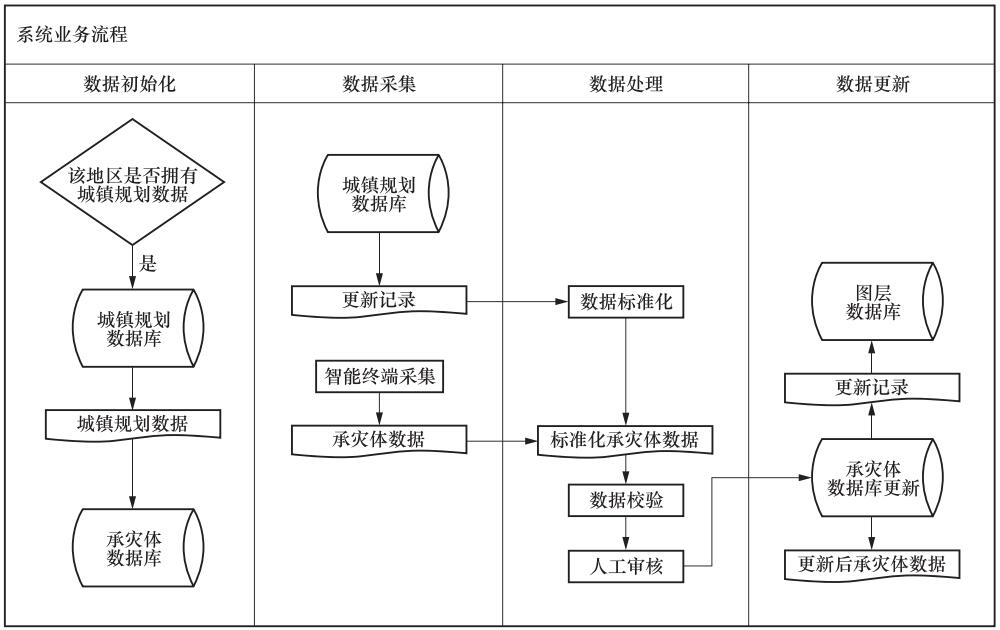
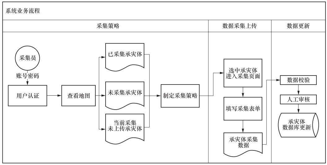
摘要: 在我国各地区承灾体特征差异性明显,且西南地区经历多次灾后重建,承灾体种类及其脆弱性呈多元化趋势的情况下,传统的通用数据标准已不再适用。此外,传统手工填写的数据采集方式导致数据汇总耗时耗力,且无法保障数据的准确性、一致性和时效性,严重影响了震害预测和灾后应急响应等工作的开展。本文以城镇规划数据为基础,依托智能移动终端,构建数据采集与动态更新一体化系统。系统通过对数据采集条目与流程进行定制优化,使其适应西南地区县城情境,实现了数据的标准化采集和实时录入。同时系统与城镇规划数据有机结合,利用实时采集的承灾体数据对城镇规划数据进行动态更新。其次引入智能化的承灾体数据交叉自动检验模块,确保数据准确。四川省丹棱县的应用示范表明,本系统显著改进了承灾体数据采集的准确性、一致性与更新速度,极大地减轻了工作人员的工作负担,为灾情获取和评估打下坚实基础,有效提高了西南县市震害防御和应急救援能力。Abstract: Hazard-affect buildings in different regions of China have various features. After many times of post-earthquake reconstruction, hazard-affect buildings in southwestern China, together with their vulnerabilities, have a diversification tendency, which results in unworkable of convolutional common-used data standard in southwestern China. Additionally, traditional manually-form-entry method is a quite time-consuming and labor-intensive way for data collection, let alone the impossible guarantee of data accuracy, consistency, and timeliness, which finally leads to a serious effect on earthquake damage prediction and post-disaster response. Based on the urban planning data and the intelligent mobile terminal technology, this paper builds an integrated system of data collection and dynamic updating. First, the system optimizes the items and process of data collection, so that it can adapt to the situation of counties in southwest region and achieve the standard data collection and real-time entering. The system also combines and leverages urban planning data and is able to dynamic updating urban planning data with the help of collected hazard-affect buildings data. Second, the intelligent cross-checking module ensures the accuracy and effectiveness of data. The application demonstration in Danling county shows that the system significantly improves the accuracy, consistency and update speed of the data, which greatly reduces the workload of the staff. The system lays a solid foundation for disaster acquisition and evaluation. Moreover, it effectively improves the capabilities of disaster prevention and emergency rescue for many counties in southwestern China.
-
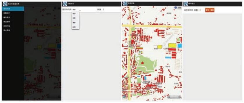
图 6 采集统计与缓存提交界面
Figure 6. Interface of collection statistics and cache data submission
表 1 建筑物信息采集内容
Table 1. Information collected for buildings
序号 采集字段 字段取值 1 名称 手动输入 2 层数 手动输入 3 结构类型 砖混结构、框架结构、框剪(框筒)结构、砖木结构、土木结构、钢结构、混凝土小砌块结构、木结构、穿斗木结构、生土结构、石结构、其它 4 平立面 规整,不规整 5 建设年代 1979年以前、1980年至1989年、1990年至2000年、2001年至2008年、2009至2013年、2013年以后 6 设防标准 未设防、Ⅵ度设防、Ⅶ度设防、Ⅷ度设防、Ⅸ度设防 7 结构现状 完好、开裂、腐蚀、不均匀沉陷 8 用途 住宅、办公、商住、商业、其它、已拆 9 重要建筑 政府部门、学校、医院、公安(消防、武警)、大型公共场所  下载: 导出CSV
-
安基文, 徐敬海, 聂高众等, 2015.高精度承灾体数据支撑的地震灾情快速评估.地震地质, 37(4):1225-1241. http://d.old.wanfangdata.com.cn/Periodical/dzdz201504022 陈洪富, 2012. HAZ-China地震灾害损失评估系统设计及初步实现. 哈尔滨: 中国地震局工程力学研究所. http://www.wanfangdata.com.cn/details/detail.do?_type=degree&id=Y2131947 国家地震社会服务工程震害防御规范编写组, 2011. 震害防御信息服务数据采集规范(试行稿). 黄经国, 李正媛, 陶冶等, 2017.基于SFTP的GNSS数据采集软件的设计与实现.震灾防御技术, 12(2):409-414. doi: 10.11899/zzfy20170218 龙立, 孙龙飞, 郑山锁等, 2016.基于Android的城市建筑物信息外业采集系统研究.震灾防御技术, 11(3):682-691. doi: 10.11899/zzfy20160325 史培军, 孔锋, 叶谦等, 2014.灾害风险科学发展与科技减灾.地球科学进展, 29(11):1205-1211. doi: 10.11867/j.issn.1001-8166.2014.11.1205 王铮, 2015. 基于承灾体的区域灾害风险及其评估研究. 大连: 大连理工大学. http://www.wanfangdata.com.cn/details/detail.do?_type=degree&id=Y2822294 徐柳华, 陈捷, 陈少勤, 2012.基于iPad的移动外业信息采集系统研究与试验.测绘通报, (12):75-78. http://www.cnki.com.cn/Article/CJFDTotal-GTDK201410026.htm 张斌, 赵前胜, 姜瑜君, 2010.区域承灾体脆弱性指标体系与精细量化模型研究.灾害学, 25(2):36-40. http://www.doc88.com/p-012708479647.html 张培震, 邓起东, 张竹琪等, 2013.中国大陆的活动断裂、地震灾害及其动力过程.中国科学:地球科学, 43(10):1607-1620. http://www.wenkuxiazai.com/doc/81d94fc776c66137ee0619f7.html 张翼, 郭红梅, 胡斌等, 2014.基于PDA的四川灾情速报系统.华南地震, 34(4):55-60. http://mall.cnki.net/magazine/Article/DZGJ2013Z2042.htm 张云龙, 2006. 小城镇总体规划空间数据标准研究. 南京: 南京师范大学. http://cdmd.cnki.com.cn/Article/CDMD-10319-2006153575.htm Annunziato A., Gadenz S., Galliano D. A., et al., 2010. Field tracking tool: a collaborative framework from the field to the decision makers. In: Konecny M., Zlatanova S., Bandrova T., eds., Geographic Information and Cartography for Risk and Crisis Management. Berlin Heidelberg: Springer, 287-303 doi: 10.1007/978-3-642-03442-8_20 Coburn A., Spence R., 2002. Earthquake protection. 2nd ed. West Sussex: John Wiley. Federal Emergency Management Agency (FEMA), 2002. Rapid visual screening of buildings for potential seismic hazards: a handbook. 2nd ed. Redwood City, California: FEMA. Sahar L., Muthukumar S., French S. P., 2010. Using aerial imagery and GIS in automated building footprint extraction and shape recognition for earthquake risk assessment of urban inventories. IEEE Transactions on Geoscience and Remote Sensing, 48(9):3511-3520. doi: 10.1109/TGRS.2010.2047260 Saito K., Spence R., 2011. Mapping urban building stocks for vulnerability assessment-preliminary results. International Journal of Digital Earth, 4(S1):117-130. http://adsabs.harvard.edu/abs/2011IJDE....4S.117S Wieland M., Pittore M., Parolai S., 2012.Estimating building inventory for rapid seismic vulnerability assessment:Towards an integrated approach based on multi-source imaging. Soil Dynamics and Earthquake Engineering, 36:70-83 doi: 10.1016/j.soildyn.2012.01.003 -


 点击查看大图
图(9) / 表(1)
计量
- 文章访问数: 168
- HTML全文浏览量: 132
- PDF下载量: 2
- 被引次数: 0
