
Preliminary Application of Hyperspectral Remote Sensing Technology in Earthquake Damage Assessment
-
摘要: 高光谱遥感作为20世纪空间对地观测技术重大进步的产物,通过其较高的光谱分辨率,为人们提供了丰富的地球表面信息,在各个研究领域得到了快速发展和广泛应用,并取得了卓越的成果。尽管高光谱遥感具有独特的优势,但是针对其在震害评估领域中应用的相关研究较少。本文在总结高光谱遥感的特征、优势及不同领域应用现状的基础上,开展了其在震害评估领域的应用研究。基于ASD地物波谱仪获取的建(构)筑物光谱曲线构建可用于震害分析所需的光谱特征库,对比光谱库中地物曲线之间的差异后,发现高光谱遥感在震害评估领域中的应用是可行的,因不同震害地物之间的光谱特征曲线存在差异,依据这种差异可区分不同的震害信息,从而对震害遥感图像进行精细分类。Abstract: As the development and major progress of the space to earth observation technology in the twentieth century, hyper spectral remote sensing has been extensively applied in various fields of research with its high spectral resolution, which provides rich information of earth surface. Although hyper spectral remote sensing is of unique superiority, no much effort has been put on seismic damage. assessment so far. Based on the summary of the characteristic advantages and application situation, earthguake damage assessment is carried out by using hyper spectral remote sensing. A typical damaged feature spectral library is constructed through collecting the spectral characteristic curves of different structures. The difference between the different spectral curves was identified, and the relationship between spectral curve and seismic damage information was explored. Our results suggest that it is feasible to apply hyper spectral remote sensing in earthquake disaster assessment. Different damage features have different spectral characteristic curves. And then, earthguake damage information can be well classified based on the spectral differences.
-
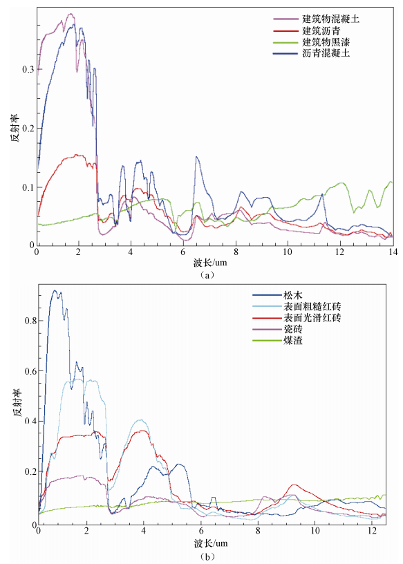
图 1 不同建筑物材料光谱特征曲线
Figure 1. Spectral characteristic curves of different building materials
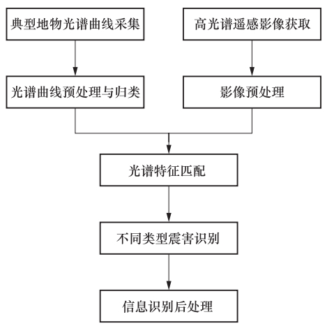
图 2 高光谱遥感影像震害信息识别技术流程图
Figure 2. Flowchart of seismic disaster information identification technique for hyperspectral remote sensing image
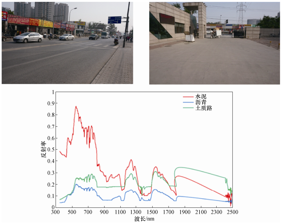
图 3 实验采集地点及光谱特征曲线
Figure 3. Experimental data collection sites and corresponding spectral characteristic curves
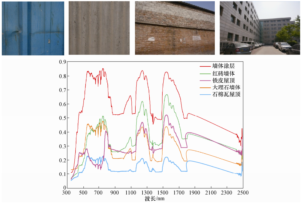
图 4 实验采集地点及光谱特征曲线
Figure 4. Experimental data collection sites and corresponding spectral characteristic curves
-
崔丽华, 2009.汶川地震前的遥感信息异常及其机理研究.唐山:河北理工大学. 崔月菊, 杜建国, 2011. 地震有关的卫星高光谱气体地球化学异常. 见: 中国地球物理学会编. 中国地球物理学会第二十七届年会论文集. 郭广猛, 曹云刚, 龚建明, 2006.使用MODIS和MOPITT卫星数据监测震前异常.地球科学进展, 2(7):695-698. http://www.cnki.com.cn/Article/CJFDTOTAL-DXJZ200607005.htm 宫鹏, 蒲瑞良, 郁彬, 1998.不同季相针叶树种高光谱数据识别分析.遥感学报, 2(3):211-217. doi: 10.11834/jrs.19980310 胡秀清, 刘京晶, 邱康睦等, 2009.神舟三号飞船中分辨率成像光谱仪场地替代定标新方法研究.光谱学与光谱分析, 29(5):1153-1159. http://www.cnki.com.cn/Article/CJFDTOTAL-GUAN200905000.htm 路威, 2005.面向目标探测的高光谱影像特征提取与分类技术研究.郑州:中国人民解放军信息工程大学. 刘伟东, 2002.高光谱遥感土壤信息提取与挖掘研究.北京:中国科学院研究生院 (遥感应用研究所). 童庆禧, 2008.我国高光谱遥感的发展.中国测绘报, (3):1-3. http://cdmd.cnki.com.cn/Article/CDMD-10616-1013288450.htm 杨国鹏, 2007.基于核方法的高光谱影像分类与特征提取.郑州:中国人民解放军信息工程大学. 杨哲海, 韩建峰, 宫大鹏等, 2003.高光谱遥感技术的发展与应用.海洋测绘, 23(6):55-58. http://www.cnki.com.cn/Article/CJFDTOTAL-HYCH200306018.htm 姚清林, 强祖基, 王弋平, 2005.青藏高原地震前CO的排放与卫星热红外增温异常.地球科学进展, 20(5):505-510. http://www.cnki.com.cn/Article/CJFDTOTAL-DXJZ200505004.htm 张成业, 秦其明, 陈理等, 2015.高光谱遥感岩矿识别的研究进展.光学精密工程, 23(8):2407-2418. http://www.cnki.com.cn/Article/CJFDTOTAL-GXJM201508036.htm 赵志芳, 谈树成, 王锋德, 2012.ASTER数据矿化蚀变异常信息提取方法研究.国土资源科技管理, 29(6):44-50. http://www.cnki.com.cn/Article/CJFDTOTAL-DZKG201206008.htm 周子勇, 2014.高光谱遥感油气勘探进展.遥感技术与应用, 29(2):352-361. http://www.cnki.com.cn/Article/CJFDTOTAL-YGJS201402025.htm Bergeron M., Hollinger A., Staenz K., et al., 2008. Hyperspectral Environment and Resource Oberver (HERO) Mission.Canadian Journal of Remote Sensing, 34(S1):S1-S11. Beck R., 2003. EO-1 User Guide Version 2.3. Street Sioux Falls:Satellite Systems Branch, USGS Earth Resources Observation System Data Center (EDC). Ganguly N. D., 2011. The impact of transported ozone-rich air on the atmospheric ozone content following the 26 January 2001 and 7 March 2006 Gujarat earthquakes. Remote Sensing Letters, 2(3):195-202. doi: 10.1080/01431161.2010.508798 Kruse F. A., Taranik J. V., Coolbaugh M., et al., 2011.Effect of reduced spatial resolution on mineral mapping using imaging spectrometry-examples using hyper spectral infrared imager (hyspiri)-simulated data. Reomte Sensing, 3(8):1584-1602. Mielke C., Boescche N. K., Rogass C., et al., 2014.Spaceborne mine waste mineralogy monitoring in south Africa, applications for modern push-broom missions:Hyperion/OLI and EnMAP/Sentinel-2.Remote Sensing, 6(8):6790-6816. doi: 10.3390/rs6086790 Okada Y., Mukai S., Singh R. P., 2004.Changes in atmospheric aerosol parameters after Gujarat earthquake of January 26, 2001. Advances in Space Research, 33(3):254-258. https://www.researchgate.net/publication/222399420_Changes_in_atmospheric_aerosol_parameters_after_Gujarat_earthquake_of_January_26_2001 Pulinets S. A., Dunajecka M. A., 2007. Specific variations of air temperature and relative humidity around the time of Michoacan earthquake MS 8.1 Sept.19, 1985 as a possible indicator of interaction between tectonic plates. Tectonophysics, 431(1-4):221-230. doi: 10.1016/j.tecto.2006.05.044 Rogge D., Rivard B., Segl K., et al., 2014.Mapping of NiCu-PGE ore hosting ultramafic rocks using airborne and simulated EnMAP hyper spectral imagery, Nunavik, Canada. Remote Sensing of Environment, 152:302-317. doi: 10.1016/j.rse.2014.06.024 Singh R. P., Cervone G., Singh V. P., et al., 2007. Generic precursors to coastal earthquakes:Inferences from Denali fault earthquake. Tectonophysics, 431(1-4):231-240. doi: 10.1016/j.tecto.2006.05.040 Singh R. P., Kumar J. S., Zlotnicki J., et al., 2010a. Satellite detection of carbon monoxide emission prior to the Gujarat earthquake of 26 January 2001. Applied Geochemistry, 25(4):580-585. doi: 10.1016/j.apgeochem.2010.01.014 Singh R. P., Mehdi W., Sharma M., 2010b. Complementary nature of surface and atmospheric parameters associated with Haiti earthquake of 12 January 2010. Natural Hazards and Earth System Science, 10(6):1299-1305. doi: 10.5194/nhess-10-1299-2010 -

 下载:
下载:
 点击查看大图
计量
- 文章访问数: 195
- HTML全文浏览量: 174
- PDF下载量: 13
- 被引次数: 0
